INVEST 96L
Moderator: S2k Moderators
Forum rules

The posts in this forum are NOT official forecasts and should not be used as such. They are just the opinion of the poster and may or may not be backed by sound meteorological data. They are NOT endorsed by any professional institution or STORM2K. For official information, please refer to products from the National Hurricane Center and National Weather Service.
-
Frank P
- S2K Supporter

- Posts: 2779
- Joined: Fri Aug 29, 2003 10:52 am
- Location: Biloxi Beach, Ms
- Contact:
Yeah but check out the IR loops on this wave, almost seems like it moving NW, if that is the case that would bode well for the islands.. where it ends up down the road remains to be seen... also a tiny bit of convection has sorta flared up in the eastern Caribbean, don't expect much of anything to develop but something to watch if it persists..
0 likes
-
Matt-hurricanewatcher
The hurricane models shows this heading northward. The Gfdl shows a northward fellowed by a northwest track. The Gfs shows a northwest fellowed by a west-northwest.
So yes this will likely be a fish by the trough build down. Also the latest visible shows what maybe a center under the convection near 14 north/44. This system is getting organized. Should be interesting to watch. The Gfdl likes this system alot!
So yes this will likely be a fish by the trough build down. Also the latest visible shows what maybe a center under the convection near 14 north/44. This system is getting organized. Should be interesting to watch. The Gfdl likes this system alot!
0 likes
-
cycloneye

- Admin

- Posts: 148790
- Age: 69
- Joined: Thu Oct 10, 2002 10:54 am
- Location: San Juan, Puerto Rico
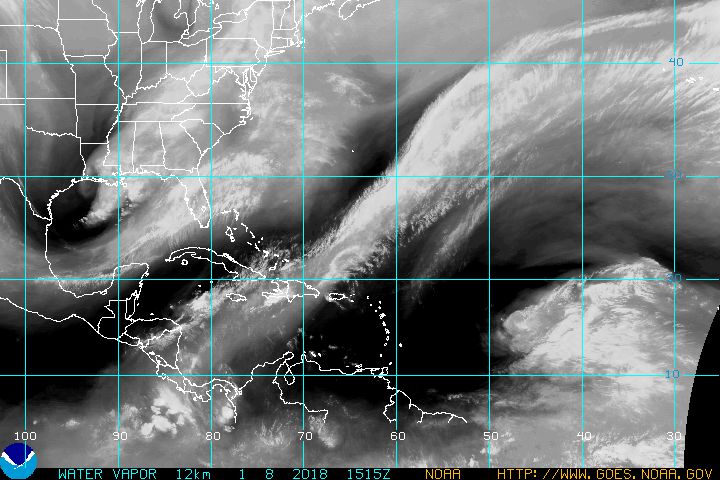
I am going out on a limb to say that the Leeward Islands will not see this system as already it's moving NW and being the longitud where it is around 44w a monster subtropical ridge has to build to then force 96 west but the saving grace for the NE CAribbean Islands has been a well defined trough that has dipped into the deep tropics as seen at pic below.
0 likes
-
Hyperstorm

- Category 5

- Posts: 1500
- Joined: Sun Sep 07, 2003 3:48 am
- Location: Ocala, FL
This morning, I think we can safely assure that this system will totally miss the Lesser Antilles.
Satellite images indicate that thunderstorm activity is increasing in association with the area of low pressure east of the Lesser Antilles. This was the ingredient needed for improved organization. This also means that the system is becoming just slightly more deeper, which should allow it to recurve to the NW. If it had stayed with more of a shallow convection, it could have kept going more WNW. However, I think the development of convection this morning has more to do with it approaching the trough (and therefore being in the favorable area for thunderstorm development), than forcing occuring out of the low pressure itself.
Dry air (SAL) has definitely kept this system in check and it appears that shear will do so next. During the next 24 hours, this system will be approaching some faster moving UL SW shear (in fact, outflow is becoming SW ahead of the storm as I type) and development, thereafter, will be slow, if any. As I had suspected earlier, due to the environment that awaits the system, the SHIPS model has backed off from bringing the storm to hurricane status, and that looks very reasonable.
Watch the powerful wave about to emerge Africa within the next 24-48 hours...
0 likes
-
Matt-hurricanewatcher
This system will likely fellow the front side of the trough. In which it will run with the shearing enviroment. In two the LLC is firing convection over it. So this maybe a tropical storm already. Its possible that the southeast quad of the jet max off the trough is forming the convection but thats a good thing for the cyclone. Remember Lisa of last year.
Also I do not know where you get some of your thinking. Because it is forming it over the LLC which is spinning the system up=Cyclone. It makes really no difference.
Also I do not know where you get some of your thinking. Because it is forming it over the LLC which is spinning the system up=Cyclone. It makes really no difference.
Last edited by Matt-hurricanewatcher on Sat Aug 13, 2005 6:31 am, edited 1 time in total.
0 likes
-
WindRunner

- Category 5
- Posts: 5806
- Age: 35
- Joined: Fri Jul 29, 2005 8:07 pm
- Location: Warrenton, VA, but Albany, NY for school
- Contact:
-
Matt-hurricanewatcher
Take a look at this. That convection is clearly forming around the LLC. Yes there is shear but should Alison,Arlene or many of the other systems have not been upgraded because of it?
This system looks good.
http://www.cira.colostate.edu/ramm/rmsd ... PICAL.html
Also SAL is no longer as strong as it was even 24 hours ago. It is starting to brake up. So if Irene moved through deep SAL for days this should do just find with 15 to 20 knot shear.
A deep SAL is alot worst then 15 to 20 knot shear. At least thats what I heard.
0 likes
-
Hyperstorm
- Category 5
- Posts: 1500
- Joined: Sun Sep 07, 2003 3:48 am
- Location: Ocala, FL
Matt-hurricanewatcher wrote:Take a look at this. That convection is clearly forming around the LLC. Yes there is shear but should Alison,Arlene or many of the other systems have not been upgraded because of it?
This system looks good.
http://www.cira.colostate.edu/ramm/rmsd ... PICAL.html
Also SAL is no longer as strong as it was even 24 hours ago. It is starting to brake up. So if Irene moved through deep SAL for days this should do just find with 15 to 20 knot shear.
A deep SAL is alot worst then 15 to 20 knot shear. At least thats what I heard.
Matt,
I never said anything regarding the development of convection not being over the LLC. I just said that environment just ahead of it, is showing signs of UL SW winds very soon impinging on the storm. It has not happened, yet.
I agree that SAL is not as strong, but until the system mixes it out with persistent deep convection, it will remain a problem. We could be starting to see that this morning.
0 likes
-
Matt-hurricanewatcher
-
linkerweather

- Professional-Met

- Posts: 261
- Joined: Sat Jul 23, 2005 5:59 am
- Location: tampa bay area
-
Hyperstorm
- Category 5
- Posts: 1500
- Joined: Sun Sep 07, 2003 3:48 am
- Location: Ocala, FL
Matt-hurricanewatcher wrote:I agree, but it is looking like it will likely become at least a 40 knot tropical storm. Yes theres shear with some SAL. I don't expect this to become a strong system because of what you stated. But don't be suprized when ew have another name on the list. In could be soon.
Sure, it will likely become a tropical depression either later today or tonight. Thereafter, it will all depend on the rate of continued organization. I believe we won't see this go higher than a moderate tropical storm during the next couple of days due to the environment ahead of it. If the trough closes off, we could see more development once it goes north of the latitude of the islands.
0 likes
-
cycloneye
- Admin
- Posts: 148790
- Age: 69
- Joined: Thu Oct 10, 2002 10:54 am
- Location: San Juan, Puerto Rico
TROPICAL DEPRESSION INVEST (AL962005) ON 20050813 1200 UTC
...00 HRS... ...12 HRS... ...24 HRS... ...36 HRS...
050813 1200 050814 0000 050814 1200 050815 0000
LAT LON LAT LON LAT LON LAT LON
BAMD 13.6N 43.7W 14.8N 44.8W 16.0N 45.5W 17.2N 46.1W
BAMM 13.6N 43.7W 14.6N 44.8W 15.5N 45.7W 16.4N 46.4W
A98E 13.6N 43.7W 14.7N 44.7W 15.8N 45.9W 17.4N 47.0W
LBAR 13.6N 43.7W 14.9N 44.6W 16.5N 45.4W 17.8N 46.2W
SHIP 25KTS 28KTS 31KTS 34KTS
DSHP 25KTS 28KTS 31KTS 34KTS
...48 HRS... ...72 HRS... ...96 HRS... ..120 HRS...
050815 1200 050816 1200 050817 1200 050818 1200
LAT LON LAT LON LAT LON LAT LON
BAMD 18.4N 46.9W 21.3N 48.8W 24.8N 50.8W 27.7N 51.3W
BAMM 17.1N 47.3W 18.8N 49.8W 20.9N 53.0W 23.7N 56.3W
A98E 19.3N 47.8W 24.5N 49.5W 28.5N 50.3W 30.7N 47.7W
LBAR 19.0N 47.4W 22.7N 50.8W 26.8N 54.3W 31.1N 53.7W
SHIP 38KTS 44KTS 50KTS 55KTS
DSHP 38KTS 44KTS 50KTS 55KTS
...INITIAL CONDITIONS...
LATCUR = 13.6N LONCUR = 43.7W DIRCUR = 320DEG SPDCUR = 7KT
LATM12 = 12.4N LONM12 = 42.8W DIRM12 = 313DEG SPDM12 = 7KT
LATM24 = 11.8N LONM24 = 41.3W
WNDCUR = 25KT RMAXWD = 30NM WNDM12 = 25KT
CENPRS = 1009MB OUTPRS = 1013MB OUTRAD = 175NM SDEPTH = D
RD34NE = 0NM RD34SE = 0NM RD34SW = 0NM RD34NW = 0NM
No TD this morning.
0 likes
Visit the Caribbean-Central America Weather Thread where you can find at first post web cams,radars
and observations from Caribbean basin members Click Here
and observations from Caribbean basin members Click Here

-
Matt-hurricanewatcher
-
Hyperstorm
- Category 5
- Posts: 1500
- Joined: Sun Sep 07, 2003 3:48 am
- Location: Ocala, FL
Matt-hurricanewatcher wrote:That blows me away. The system by that visible looks to be wraping its self into a ball with banding all around. But who knows.
Be patient, Matt. It is definitely becoming better organized. The Dvorak satellite agencies are now calling it a 1.5, which is close to being called a depression. Either at 5 or 11, if convection continues to increase...
0 likes
-
cycloneye
- Admin
- Posts: 148790
- Age: 69
- Joined: Thu Oct 10, 2002 10:54 am
- Location: San Juan, Puerto Rico
13/1145 UTC 13.4N 43.9W T1.5/1.5 96 -- Atlantic Ocean
T numbers crepping up now to 1.5.This afternoon or tonight if trend of organization continues we will see TD#10.
T numbers crepping up now to 1.5.This afternoon or tonight if trend of organization continues we will see TD#10.
0 likes
Visit the Caribbean-Central America Weather Thread where you can find at first post web cams,radars
and observations from Caribbean basin members Click Here
and observations from Caribbean basin members Click Here

I expect TD 10 at 11AM. Looking more and more organized this morning.
WE shall see.
WE shall see.
0 likes
The following post is NOT an official forecast and should not be used as such. It is just the opinion of the poster and may or may not be backed by sound meteorological data. It is NOT endorsed by any professional institution including storm2k.org For Official Information please refer to the NHC and NWS products.
-
Hyperstorm
- Category 5
- Posts: 1500
- Joined: Sun Sep 07, 2003 3:48 am
- Location: Ocala, FL
KatDaddy wrote:I expect TD 10 at 11AM. Looking more and more organized this morning.
WE shall see.
As you said, we shall see. T-numbers support a 30 mph tropical depression. It will all depend on the forecaster on duty, if they want to name it a tropical depression with 30 mph winds at 11am. It has happened in the past, for example with Irene, that it was upgraded with 30 mph winds in the first advisory.
I really would like to see some persistence of convection before upgrading it...
0 likes
-
Matt-hurricanewatcher
Who is online
Users browsing this forum: wwizard and 120 guests