Here's more images of Isabel. Just click away...
http://www5.ncdc.noaa.gov/cgi-bin/hsei/hsei.pl
What Was The Most Impressive Hurricane on Imagery?
Moderator: S2k Moderators
Forum rules

The posts in this forum are NOT official forecasts and should not be used as such. They are just the opinion of the poster and may or may not be backed by sound meteorological data. They are NOT endorsed by any professional institution or STORM2K. For official information, please refer to products from the National Hurricane Center and National Weather Service.


-
Jim Cantore
-
HurricaneBill
- Category 5

- Posts: 3419
- Joined: Sun Apr 11, 2004 5:51 pm
- Location: East Longmeadow, MA, USA
-
wxmann_91

- Category 5
- Posts: 8007
- Age: 34
- Joined: Fri Jul 15, 2005 2:49 pm
- Location: Southern California
- Contact:
CapeVerdeWave wrote:Here's more images of Isabel. Just click away...
http://www5.ncdc.noaa.gov/cgi-bin/hsei/hsei.pl
It ain't workin, this is what it says:
Notice! The URL you are attempting to access is not valid....
0 likes
-
Lowpressure

- S2K Supporter

- Posts: 2032
- Age: 59
- Joined: Sun Sep 14, 2003 9:17 am
- Location: Charlotte, North Carolina
-
docjoe

- S2K Supporter
- Posts: 261
- Joined: Thu Sep 09, 2004 10:42 pm
- Location: SE Alabama..formerly the land of ivan and dennis
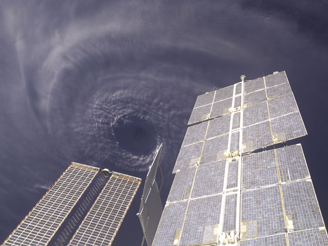
http://antwrp.gsfc.nasa.gov/apod/image/0409/ivan_iss.jpg
this picture of ivan, from astronomy picture of the day, is one of my favorite hurricane pics ever. I think it is classic.
docjoe
this picture of ivan, from astronomy picture of the day, is one of my favorite hurricane pics ever. I think it is classic.
docjoe
0 likes

-
ts_kakolina

- Tropical Depression

- Posts: 58
- Joined: Wed Jul 13, 2005 8:27 am
- Location: Carolina, Puerto Rico
Maybe because in Puerto Rico we had a "close encounter" with him, I remember Georges (1998) as a very impressive one. Georges is not even in your list. 
http://www1.ncdc.noaa.gov/pub/data/imag ... 9-g8ir.gif
http://www1.ncdc.noaa.gov/pub/data/imag ... 2-g8ir.gif
PD. When you are in a 100 x 35 miles (aprox.) island you see hurricanes near you from another perspective
http://www1.ncdc.noaa.gov/pub/data/imag ... 9-g8ir.gif
http://www1.ncdc.noaa.gov/pub/data/imag ... 2-g8ir.gif
PD. When you are in a 100 x 35 miles (aprox.) island you see hurricanes near you from another perspective
0 likes
-
wxmann_91
- Category 5
- Posts: 8007
- Age: 34
- Joined: Fri Jul 15, 2005 2:49 pm
- Location: Southern California
- Contact:
Nice visible loop of Mitch on Oct 26 (from Unisys):
http://weather.unisys.com/hurricane/atlantic/1998H/MITCH/Mit_v.gif
http://weather.unisys.com/hurricane/atlantic/1998H/MITCH/Mit_v.gif
0 likes
-
wxmann_91
- Category 5
- Posts: 8007
- Age: 34
- Joined: Fri Jul 15, 2005 2:49 pm
- Location: Southern California
- Contact:
ts_kakolina wrote:Maybe because in Puerto Rico we had a "close encounter" with him, I remember Georges (1998) as a very impressive one. Georges is not even in your list.
http://www1.ncdc.noaa.gov/pub/data/imag ... 9-g8ir.gif
http://www1.ncdc.noaa.gov/pub/data/imag ... 2-g8ir.gif
PD. When you are in a 100 x 35 miles (aprox.) island you see hurricanes near you from another perspective
This is a great image of Georges:
http://rsd.gsfc.nasa.gov/goes/pub/goes/980919.georges.jpeg
But of course if the person who created this thread listed every extremely impressive hurricane that occurred even within the last 25 years, the list would be too long.
Other recent examples of impressive canes would be Edouard (1996), Iris (2001), Isaac (2000), Bob (1991), Elena (1985), Michelle (2001), Isidore (2002), and Lili (2002).
Please keep these pics of impressive 'canes coming. Really enjoy them.
0 likes
-
Matt-hurricanewatcher
I'm suprized Emily did not get a few votes. It happen this year. In had for a short time became a cat5 based on the 153 knot flight level wind the Nhc recon found. That the nhc said there selfs that it might of been a cat5 for a short time around 03z. More powerful then Frances or Jeanne or Keith you got on your list. Also more powerful then Charley,Karl,Donna,"Floyd"(Offically a tie).
0 likes
-
wxmann_91
- Category 5
- Posts: 8007
- Age: 34
- Joined: Fri Jul 15, 2005 2:49 pm
- Location: Southern California
- Contact:
Matt-hurricanewatcher wrote:I'm suprized Emily did not get a few votes. It happen this year. In had for a short time became a cat5 based on the 153 knot flight level wind the Nhc recon found. That the nhc said there selfs that it might of been a cat5 for a short time around 03z. More powerful then Frances or Jeanne or Keith you got on your list. Also more powerful then Charley,Donna,Floyd.
Not strength but beauty. Emily got a cool eye but IMHO b/c of impedement of outflow on the southern side it looked pretty ugly also. Keith was pretty, just take a look:
http://www.osei.noaa.gov/Events/Tropical/Atlantic/2000/TRCkeith276A_G8.jpg
And Floyd was beautiful too, and it had a lower central pressure than Emily.
0 likes
-
Matt-hurricanewatcher
Look pretty good(Emily)
http://www.osei.noaa.gov/Events/Tropica ... 97_G12.jpg
Pic of Dennis at landfall.
http://www.osei.noaa.gov/Events/Tropica ... 189_N7.jpg
Ivan 2004
http://www.osei.noaa.gov/Events/Tropica ... 52_G12.jpg
http://www.osei.noaa.gov/Events/Tropica ... 56_G12.jpg
Ivan as a cat5...Notice the cloud filled eye?
http://www.osei.noaa.gov/Events/Tropica ... 57_G12.jpg
http://www.osei.noaa.gov/Events/Tropica ... 55_G12.jpg
Jeanne Impressive!
http://www.osei.noaa.gov/Events/Tropica ... 67_G12.jpg
http://www.osei.noaa.gov/Events/Tropica ... 69_G12.jpg
http://www.osei.noaa.gov/Events/Tropica ... 269_N6.jpg
http://www.osei.noaa.gov/Events/Tropica ... 0B_G12.jpg
Alex
http://www.osei.noaa.gov/Events/Tropica ... 18_G12.jpg
http://www.osei.noaa.gov/Events/Tropica ... 217_N5.jpg
Charley
http://www.osei.noaa.gov/Events/Tropica ... 26_G12.jpg
0 likes
-
Anonymous


What about 'ol Andy? He had a very unique look in that he was almost all symmetrical "donut" for most of his westward trek, and certainly as the eye passed over South Dade. There wasn't much of that spiral arm structure, if any. It had the satellite appearance of a buzzsaw.
I envision the 1935 Labor Day storm to have been fairly similar in appearance to Andrew.
I envision the 1935 Labor Day storm to have been fairly similar in appearance to Andrew.
0 likes
-
jax

Who is online
Users browsing this forum: No registered users and 318 guests