Tropical Wave WSW of the Cabo Verde Islands (40/80)

This is the general tropical discussion area. Anyone can take their shot at predicting a storms path.

Moderator: S2k Moderators

Forum rules

The posts in this forum are NOT official forecasts and should not be used as such. They are just the opinion of the poster and may or may not be backed by sound meteorological data. They are NOT endorsed by any professional institution or STORM2K. For official information, please refer to products from the National Hurricane Center and National Weather Service.

Help Support Storm2K
Message
Author
BobHarlem
Category 5
Category 5
Posts: 2380
Joined: Thu Oct 20, 2005 6:11 pm

Re: Tropical Wave WSW of the Cabo Verde Islands (40/80)

#221 Postby BobHarlem » Wed Sep 03, 2025 1:54 pm

12z GFS Ensembles, not even close to the operational.
Image
deep mind
Image
2 likes   

Weathertracker96
Tropical Storm
Tropical Storm
Posts: 116
Joined: Mon Oct 16, 2023 3:41 pm

Re: Tropical Wave WSW of the Cabo Verde Islands (40/80)

#222 Postby Weathertracker96 » Wed Sep 03, 2025 1:57 pm

Hopefully we get an invest soon. That could start to help the ensembles & operational a little bit.
2 likes   

User avatar
chaser1
S2K Supporter
S2K Supporter
Posts: 5531
Age: 64
Joined: Sat Oct 15, 2005 5:59 pm
Location: Longwood, Fl

Re: Tropical Wave WSW of the Cabo Verde Islands (40/80)

#223 Postby chaser1 » Wed Sep 03, 2025 2:04 pm

My own speculation of a potential (but low confidence) point of consolidation at this time is around:
12.0 N and 33.0 W

Still, not identifiable enough of a feature to warrant calling it an Invest. The fact that this is slowly congealing rather than rapidly developing around an already identifiable MLC spin, suggests to me that this system could be fairly large in size.
4 likes   
Andy D

(For official information, please refer to the NHC and NWS products.)

User avatar
chaser1
S2K Supporter
S2K Supporter
Posts: 5531
Age: 64
Joined: Sat Oct 15, 2005 5:59 pm
Location: Longwood, Fl

Re: Tropical Wave WSW of the Cabo Verde Islands (40/80)

#224 Postby chaser1 » Wed Sep 03, 2025 2:27 pm

Until this organizes enough to attain some vertical depth, model projections are pointless. Best near term guess for motion would probably be BAML. Once organized enough to get a good initialization, then it's location, size, and relationship to steering flow & upper level conditions can be better number-crunched by models to give us better guidance. The way it looks, I'm thinking perhaps late tomorrow or Friday as an Invest (add a couple days for T.D.).
2 likes   
Andy D

(For official information, please refer to the NHC and NWS products.)

User avatar
Nimbus
Category 5
Category 5
Posts: 5361
Joined: Mon Jul 19, 2004 10:54 am

Re: Tropical Wave WSW of the Cabo Verde Islands (40/80)

#225 Postby Nimbus » Wed Sep 03, 2025 3:06 pm

Since it is still attached to the monsoonal trough the 12Z GFS initialized it further south than yesterdays 12Z GFS resulting in a Hugo scenario. 12Z ECM built a stronger ridge to the north driving it into the Caribbean as a weaker storm. No short wave to produce a recurve with these model runs but the GFS seems unrealistically slow.

Fair amount of moisture along the current projected track so a 20% chance that it won't develop in 7 days seems a little high.
1 likes   

MEANINGLESS_NUMBERS
Category 1
Category 1
Posts: 358
Joined: Mon Nov 02, 2020 1:43 pm

Re: Tropical Wave WSW of the Cabo Verde Islands (40/80)

#226 Postby MEANINGLESS_NUMBERS » Wed Sep 03, 2025 3:11 pm

BobHarlem wrote:12z GFS Ensembles, not even close to the operational.
https://i.imgur.com/fSRFOUS.png
deep mind
https://i.imgur.com/hFqFOXz.png


It's all about the timing of that trough which dictates recurve vs CONUS. At this range you might as well flip a coin.
0 likes   
Emily '87, Felix '95, Gert '99, Fabian '03, Humberto '19, Paulette '20, Teddy '20, Fiona '22, Lee '23, Ernesto '24

jlauderdal
S2K Supporter
S2K Supporter
Posts: 7213
Joined: Wed May 19, 2004 5:46 am
Location: NE Fort Lauderdale
Contact:

Re: Tropical Wave WSW of the Cabo Verde Islands (40/80)

#227 Postby jlauderdal » Wed Sep 03, 2025 3:16 pm

MEANINGLESS_NUMBERS wrote:
BobHarlem wrote:12z GFS Ensembles, not even close to the operational.
https://i.imgur.com/fSRFOUS.png
deep mind
https://i.imgur.com/hFqFOXz.png


It's all about the timing of that trough which dictates recurve vs CONUS. At this range you might as well flip a coin.
The AI models in a couple of years will eat this uncertainty for lunch but for now, default is recurve.

Sent from my Pixel 9 using Tapatalk
1 likes   

User avatar
Zonacane
Category 1
Category 1
Posts: 369
Joined: Tue Aug 03, 2021 2:23 pm

Re: Tropical Wave WSW of the Cabo Verde Islands (40/80)

#228 Postby Zonacane » Wed Sep 03, 2025 3:20 pm

jlauderdal wrote:
MEANINGLESS_NUMBERS wrote:
BobHarlem wrote:12z GFS Ensembles, not even close to the operational.
https://i.imgur.com/fSRFOUS.png
deep mind
https://i.imgur.com/hFqFOXz.png


It's all about the timing of that trough which dictates recurve vs CONUS. At this range you might as well flip a coin.
The AI models in a couple of years will eat this uncertainty for lunch but for now, default is recurve.

Sent from my Pixel 9 using Tapatalk

Way too early to say. We just have to wait
3 likes   

MEANINGLESS_NUMBERS
Category 1
Category 1
Posts: 358
Joined: Mon Nov 02, 2020 1:43 pm

Re: Tropical Wave WSW of the Cabo Verde Islands (40/80)

#229 Postby MEANINGLESS_NUMBERS » Wed Sep 03, 2025 3:21 pm

jlauderdal wrote:
MEANINGLESS_NUMBERS wrote:
BobHarlem wrote:12z GFS Ensembles, not even close to the operational.
https://i.imgur.com/fSRFOUS.png
deep mind
https://i.imgur.com/hFqFOXz.png


It's all about the timing of that trough which dictates recurve vs CONUS. At this range you might as well flip a coin.
The AI models in a couple of years will eat this uncertainty for lunch but for now, default is recurve.

Sent from my Pixel 9 using Tapatalk


Yeah maybe. In my field (medicine) they've been saying AI will consume us in 5 years for the last 5 years. Use cases remain very narrow. I'm not buying the hype. At some point it is a data-input issue.
0 likes   
Emily '87, Felix '95, Gert '99, Fabian '03, Humberto '19, Paulette '20, Teddy '20, Fiona '22, Lee '23, Ernesto '24

Stratton23
Category 5
Category 5
Posts: 2695
Joined: Fri Jul 21, 2023 10:59 pm
Location: Katy, Tx

Re: Tropical Wave WSW of the Cabo Verde Islands (40/80)

#230 Postby Stratton23 » Wed Sep 03, 2025 5:14 pm

18z GFS through hour 132 is more SW and weaker, looks like the SW trend continues
0 likes   

User avatar
Teban54
Category 5
Category 5
Posts: 3279
Joined: Sat May 19, 2018 1:19 pm

Re: Tropical Wave WSW of the Cabo Verde Islands (40/80)

#231 Postby Teban54 » Wed Sep 03, 2025 5:20 pm

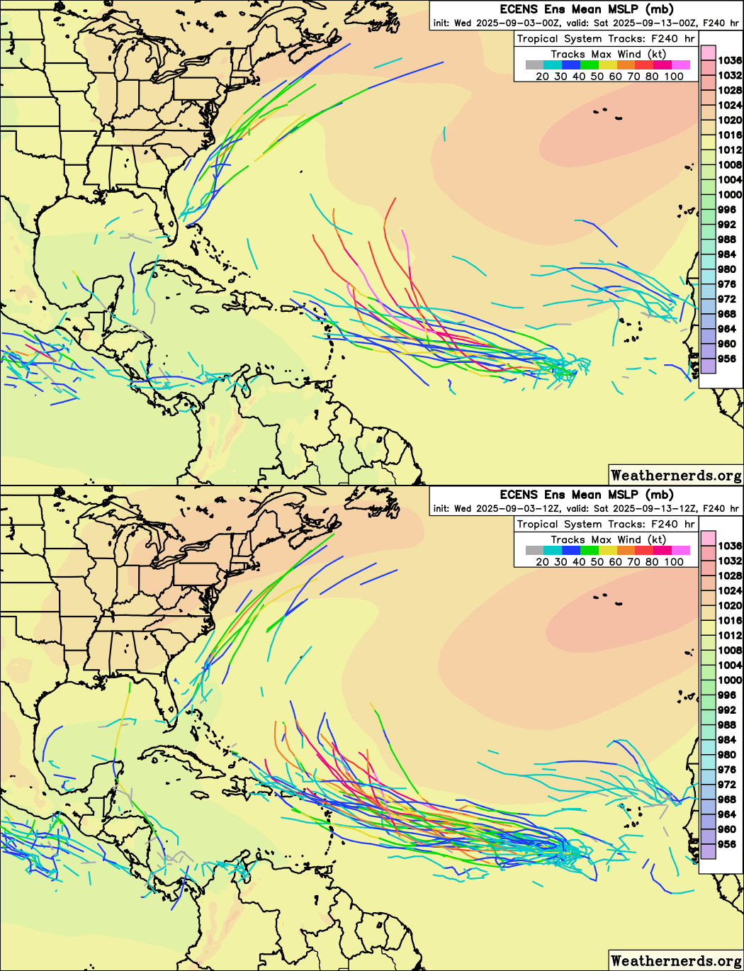
12z Euro ensembles shifted west, with seemingly greater support for development.

Image
1 likes   

AutoPenalti
Category 5
Category 5
Posts: 4065
Age: 29
Joined: Mon Aug 17, 2015 4:16 pm
Location: Ft. Lauderdale, Florida

Re: Tropical Wave WSW of the Cabo Verde Islands (40/80)

#232 Postby AutoPenalti » Wed Sep 03, 2025 5:40 pm

Gfs 18z doesn’t cut off the trough which leaves it wide open to be swept away.
0 likes   
The posts in this forum are NOT official forecasts and should not be used as such. They are just the opinion of the poster and may or may not be backed by sound meteorological data. They are NOT endorsed by any professional institution or STORM2K. For official information, please refer to products from the NHC and NWS.


Model Runs Cheat Sheet:
GFS (5:30 AM/PM, 11:30 AM/PM)
HWRF, GFDL, UKMET, NAVGEM (6:30-8:00 AM/PM, 12:30-2:00 AM/PM)
ECMWF (1:45 AM/PM)

TCVN
is a weighted averaged

Stratton23
Category 5
Category 5
Posts: 2695
Joined: Fri Jul 21, 2023 10:59 pm
Location: Katy, Tx

Re: Tropical Wave WSW of the Cabo Verde Islands (40/80)

#233 Postby Stratton23 » Wed Sep 03, 2025 6:03 pm

18z GFS says hold youre horses, north atlantic trough kicks out quickly, ridging builds in and traps this system, starts moving west towards the eastern US coast
0 likes   

Pelicane
Tropical Storm
Tropical Storm
Posts: 131
Joined: Tue Sep 13, 2022 1:52 pm
Location: Lafayette, Louisiana

Re: Tropical Wave WSW of the Cabo Verde Islands (40/80)

#234 Postby Pelicane » Wed Sep 03, 2025 6:10 pm

Downtrend on the GEFS this cycle. Still not really supporting these operational runs yet. Very large spread of possibilities in just a 5 day timeframe.
0 likes   

Stratton23
Category 5
Category 5
Posts: 2695
Joined: Fri Jul 21, 2023 10:59 pm
Location: Katy, Tx

Re: Tropical Wave WSW of the Cabo Verde Islands (40/80)

#235 Postby Stratton23 » Wed Sep 03, 2025 6:16 pm

GFS barely misses NC but absolutely pounds the NE US on this run
0 likes   


Return to “Talkin' Tropics”

Who is online

Users browsing this forum: Google [Bot], Gums, hipshot, HurricaneFan, Kazmit, MarioProtVI, ouragans, Pelicane, pepecool20, Stratton23, StrongWind, TheBurn, Ulf, WaveBreaking and 234 guests