Teban54 wrote:Landfall, weakening, and (possible) recovery:
https://i.imgur.com/CfuLpxo.gif
Wow they really hate land
Moderators: hurricanetrack, S2k Moderators


Teban54 wrote:Landfall, weakening, and (possible) recovery:
https://i.imgur.com/CfuLpxo.gif

Teban54 wrote:I didn't see the high altitude of the plane earlier when reporting FL winds. Sorry if that misled anyone.
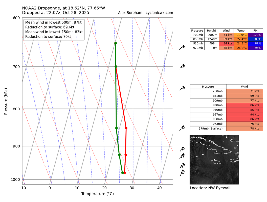
This drop is from the weaker NW eyewall, which still seems to show relatively good mixing down to the surface (as well as high FL/surface ratios).
https://i.postimg.cc/XYXN4c3k/MELISSA-NOAA2-2513A-dropsonde-202510282207.png


StormWeather wrote:Anyone know what happened to Mission 26? They did a U-turn and went back to the island they took off from.
Teban54 wrote:Teban54 wrote:I didn't see the high altitude of the plane earlier when reporting FL winds. Sorry if that misled anyone.
This drop is from the weaker NW eyewall, which still seems to show relatively good mixing down to the surface (as well as high FL/surface ratios).
https://i.postimg.cc/XYXN4c3k/MELISSA-NOAA2-2513A-dropsonde-202510282207.png
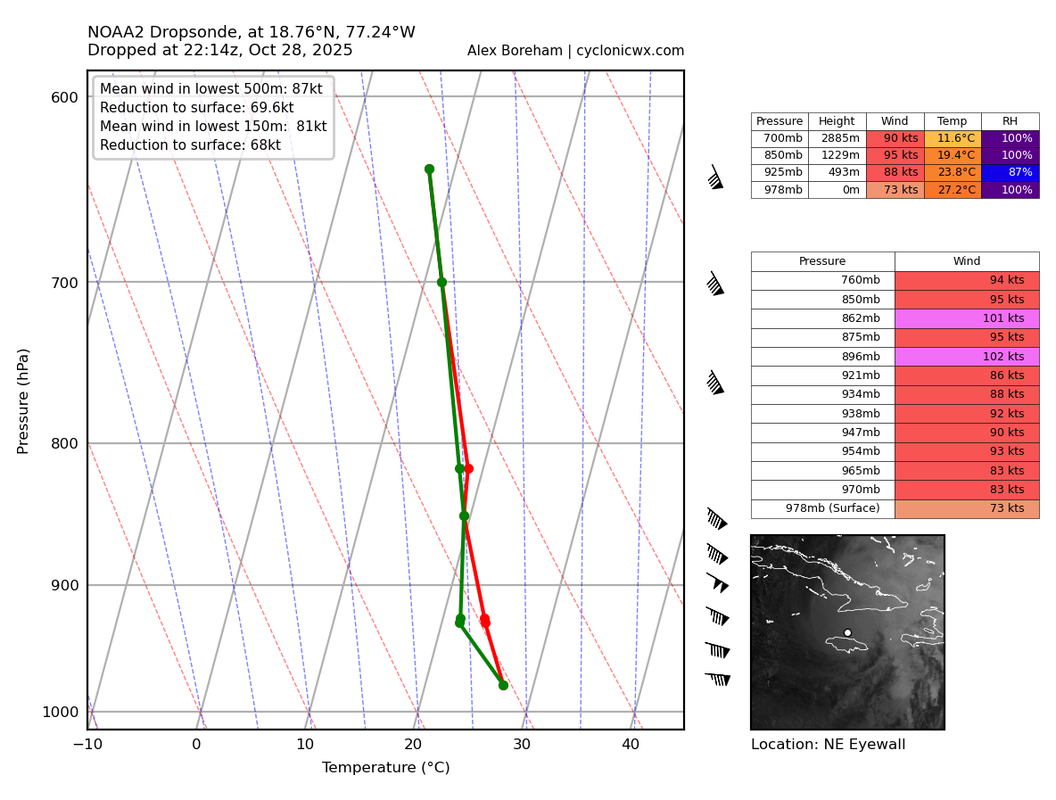
Here's the NE eyewall. While definitely not a major anymore, it probably doesn't change anything I said above fundamentally.
https://i.postimg.cc/k5dHfqjc/MELISSA-NOAA2-2513A-dropsonde-202510282214.png
syfr wrote:The level of intensity that Jamaica took from Melissa is surprising. Are "perfect" storms like Melissa, particularly vulnerable to severe attenuation , in comparison to your normal run of the mill big blob Cat III or the like?
syfr wrote:The level of intensity that Jamaica took from Melissa is surprising. Are "perfect" storms like Melissa, particularly vulnerable to severe attenuation , in comparison to your normal run of the mill big blob Cat III or the like?
ljmac75 wrote:It looks to me like the NHC went with the standard inland decay rate for Melissa's weakening after landfall (presumably because they have nothing else to go by, this is the first hurricane to take a northward track over the western side of Jamaica in almost 100 years). Works pretty well for the gulf coast, not so well for a rather rugged island.
syfr wrote:The level of intensity that Jamaica took from Melissa is surprising. Are "perfect" storms like Melissa, particularly vulnerable to severe attenuation , in comparison to your normal run of the mill big blob Cat III or the like?
AJC3 wrote:syfr wrote:The level of intensity that Jamaica took from Melissa is surprising. Are "perfect" storms like Melissa, particularly vulnerable to severe attenuation , in comparison to your normal run of the mill big blob Cat III or the like?
In spite of its strength and intensity landfall, I think the Melissa's relatively small RMW made it more easily disrupted by the high terrain of Jamaica (even though the higher peaks are on the central-east part of the island).
Nimbus wrote:Teban54 wrote:Teban54 wrote:I didn't see the high altitude of the plane earlier when reporting FL winds. Sorry if that misled anyone.
This drop is from the weaker NW eyewall, which still seems to show relatively good mixing down to the surface (as well as high FL/surface ratios).
https://i.postimg.cc/XYXN4c3k/MELISSA-NOAA2-2513A-dropsonde-202510282207.png
Here's the NE eyewall. While definitely not a major anymore, it probably doesn't change anything I said above fundamentally.
https://i.postimg.cc/k5dHfqjc/MELISSA-NOAA2-2513A-dropsonde-202510282214.png
Gusts to 60 knots currently being reported for Montego bay so this sounds reasonable.
They can't work on restoring the power lines till the wind subsides.
Cuba may luck out if we can get a little dry air entrained before landfall.
ljmac75 wrote:Nimbus wrote:Teban54 wrote:Here's the NE eyewall. While definitely not a major anymore, it probably doesn't change anything I said above fundamentally.
https://i.postimg.cc/k5dHfqjc/MELISSA-NOAA2-2513A-dropsonde-202510282214.png
Gusts to 60 knots currently being reported for Montego bay so this sounds reasonable.
They can't work on restoring the power lines till the wind subsides.
Cuba may luck out if we can get a little dry air entrained before landfall.
Where are you getting these obs for Montego bay?

Nimbus wrote:ljmac75 wrote:Nimbus wrote:
Gusts to 60 knots currently being reported for Montego bay so this sounds reasonable.
They can't work on restoring the power lines till the wind subsides.
Cuba may luck out if we can get a little dry air entrained before landfall.
Where are you getting these obs for Montego bay?
Weather Underground link updates every few minutes I've seen wind speeds as high as 75 knots in squalls.
https://www.wunderground.com/weather/jm/montego-bay
MarioProtVI wrote:Good news for Cuba but man the core got destroyed. We’re gonna be getting Erin post-ERC ratios now aren’t we. Also cuts down on the remaining ACE forecasted so it doesn’t seem like Melissa will beat Erin in terms of ACE as I don’t think it’ll regain major, and in fact the mountains of Cuba probably screw with it to the point it comes out the other side a sloppy Cat 1 or low-end 2, not the major NHC currently has tracking through there.
Return to “Active Storms/Invests - Atlantic/EastPAC/CentralPAC/MED”
Users browsing this forum: No registered users and 114 guests


