NATL: MELISSA - Aftermath - Discussion: Josh Morgerman video of Melissa is up

Moderator: S2k Moderators

Message
Author
CrazyC83
Professional-Met
Professional-Met
Posts: 34308
Joined: Tue Mar 07, 2006 11:57 pm
Location: Deep South, for the first time!

Re: NATL: MELISSA - Hurricane - Discussion

#2721 Postby CrazyC83 » Tue Oct 28, 2025 5:24 pm

aspen wrote:
Teban54 wrote:NOAA is back into Melissa and has an extrap pressure of 952.8 mb. The NW quad only has 65 kt FL, but looks like it will sample the NE quad next.

I don’t think this is even a major anymore. Wonder what the NHC will do at 8pm.


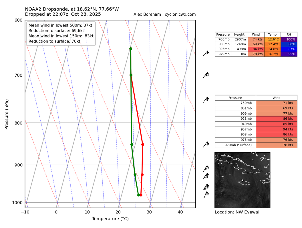
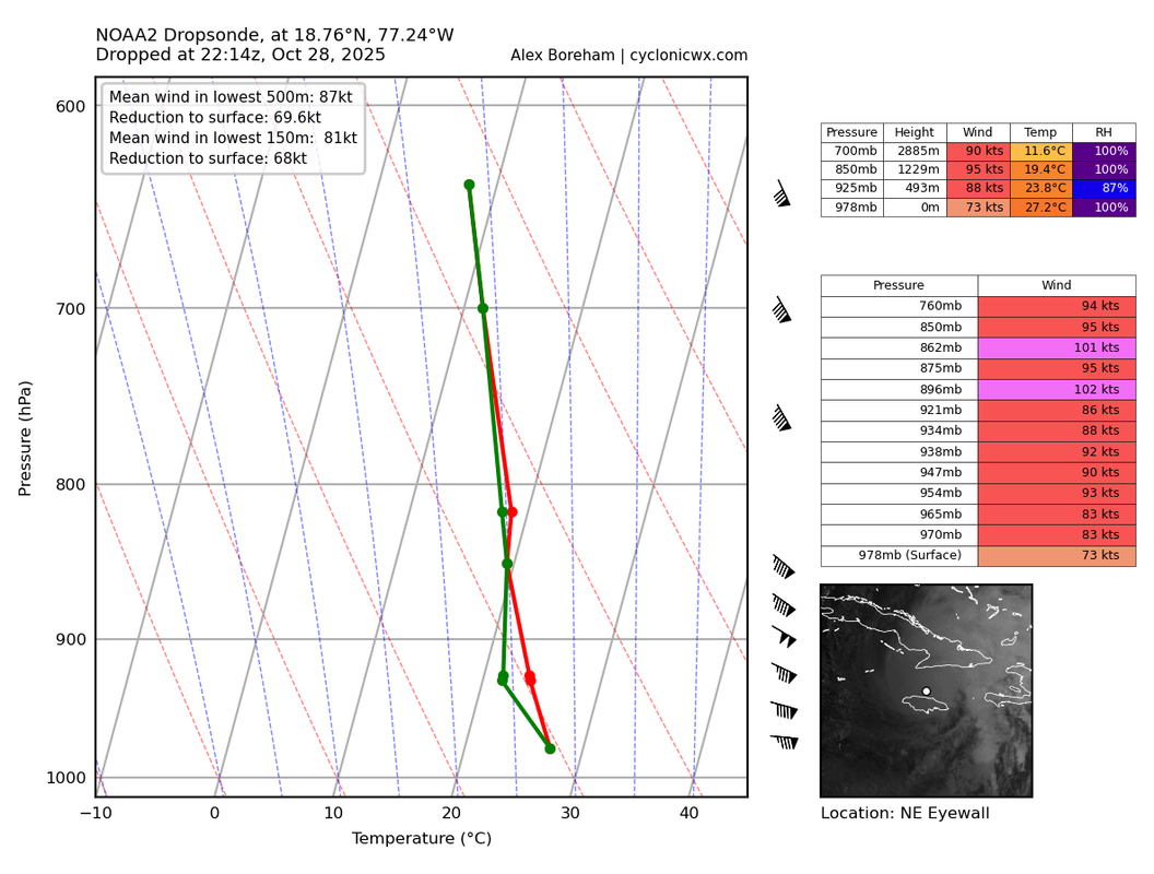
These winds are at 13,000 feet (due to the mountains nearby) which is too high to assess the winds. As a result, we aren't going to get good wind data from this plane except in dropsondes, assuming they don't land on solid ground.
6 likes   

User avatar
WaveBreaking
Category 2
Category 2
Posts: 709
Joined: Sun Jun 30, 2024 11:33 am
Location: US

Re: NATL: MELISSA - Hurricane - Discussion

#2722 Postby WaveBreaking » Tue Oct 28, 2025 5:26 pm

VHTs already firing in the eye in mesoscale imagery
1 likes   
I am NOT a professional meteorologist, so take all of my posts with a grain of salt. My opinions are mine and mine alone.

MarioProtVI
Category 5
Category 5
Posts: 1032
Age: 24
Joined: Sun Sep 29, 2019 7:33 pm
Location: New Jersey

Re: NATL: MELISSA - Hurricane - Discussion

#2723 Postby MarioProtVI » Tue Oct 28, 2025 5:26 pm

Good news for Cuba but man the core got destroyed. We’re gonna be getting Erin post-ERC ratios now aren’t we. Also cuts down on the remaining ACE forecasted so it doesn’t seem like Melissa will beat Erin in terms of ACE as I don’t think it’ll regain major, and in fact the mountains of Cuba probably screw with it to the point it comes out the other side a sloppy Cat 1 or low-end 2, not the major NHC currently has tracking through there.
0 likes   

Sciencerocks
Category 5
Category 5
Posts: 10180
Age: 39
Joined: Thu Jul 06, 2017 1:51 am

Re: NATL: MELISSA - Hurricane - Discussion

#2724 Postby Sciencerocks » Tue Oct 28, 2025 5:26 pm

aspen wrote:
Teban54 wrote:NOAA is back into Melissa and has an extrap pressure of 952.8 mb. The NW quad only has 65 kt FL, but looks like it will sample the NE quad next.

I don’t think this is even a major anymore. Wonder what the NHC will do at 8pm.


Jamaica hurt this storm bad. Such a powerful storm has all its power within a fragile eyewall and when it takes a hit like this it has a hard time.

Looks like it is around 952-953 mbs or 60 mbs higher then it made landfall at.
2 likes   

CrazyC83
Professional-Met
Professional-Met
Posts: 34308
Joined: Tue Mar 07, 2006 11:57 pm
Location: Deep South, for the first time!

Re: NATL: MELISSA - Hurricane - Discussion

#2725 Postby CrazyC83 » Tue Oct 28, 2025 5:27 pm

I'd go with 95 kt for the intensity and a pressure of 950 mb. The eye likely is a bit south of the turn point and emerged in the last 30 minutes so it's barely off the beach.
3 likes   

User avatar
mrbagyo
Category 5
Category 5
Posts: 3962
Age: 33
Joined: Thu Apr 12, 2012 9:18 am
Location: 14.13N 120.98E
Contact:

Re: NATL: MELISSA - Hurricane - Discussion

#2726 Postby mrbagyo » Tue Oct 28, 2025 5:27 pm

It's trying to wrap the eye again
Image
11 likes   
The posts in this forum are NOT official forecast and should not be used as such. They are just the opinion of the poster and may or may not be backed by sound meteorological data. They are NOT endorsed by any professional institution or storm2k.org. For official information, please refer to RSMC, NHC and NWS products.

User avatar
Woofde
Category 2
Category 2
Posts: 558
Joined: Tue Jul 06, 2021 11:33 am

Re: NATL: MELISSA - Hurricane - Discussion

#2727 Postby Woofde » Tue Oct 28, 2025 5:28 pm

Teban54 wrote:NOAA is back into Melissa and has an extrap pressure of 952.8 mb. The NW quad only has 65 kt FL, but looks like it will sample the NE quad next.
It'll probably be a case where the pressure continues to increase for 6 - 12 hours until winds recover and it begins sucking ocean warmth from the surface again. The core structure didn't fall apart though.
3 likes   

rwfromkansas
Category 5
Category 5
Posts: 2769
Joined: Sat Aug 27, 2005 12:47 am
Location: North Fort Worth

Re: NATL: MELISSA - Hurricane - Discussion

#2728 Postby rwfromkansas » Tue Oct 28, 2025 5:30 pm

MEANINGLESS_NUMBERS wrote:
rwfromkansas wrote:they should have stayed until landfall.


Easy there, hotshot. Those g-force limits are for their safety.


Oh good point, I forgot they had to leave for safety reasons.
1 likes   

User avatar
Teban54
Category 5
Category 5
Posts: 3787
Joined: Sat May 19, 2018 1:19 pm

Re: NATL: MELISSA - Hurricane - Discussion

#2729 Postby Teban54 » Tue Oct 28, 2025 5:31 pm

I didn't see the high altitude of the plane earlier when reporting FL winds. Sorry if that misled anyone.

This drop is from the weaker NW eyewall, which still seems to show relatively good mixing down to the surface (as well as high FL/surface ratios).

Image
0 likes   

JBCycloneStan
Tropical Depression
Tropical Depression
Posts: 55
Joined: Wed Sep 06, 2017 3:55 pm

Re: NATL: MELISSA - Hurricane - Discussion

#2730 Postby JBCycloneStan » Tue Oct 28, 2025 5:32 pm

MarioProtVI wrote:Good news for Cuba but man the core got destroyed. We’re gonna be getting Erin post-ERC ratios now aren’t we. Also cuts down on the remaining ACE forecasted so it doesn’t seem like Melissa will beat Erin in terms of ACE as I don’t think it’ll regain major, and in fact the mountains of Cuba probably screw with it to the point it comes out the other side a sloppy Cat 1 or low-end 2, not the major NHC currently has tracking through there.


The core was not destroyed?? lol. It’s looking to regain eye structure on IR imminently
4 likes   

User avatar
AJC3
Admin
Admin
Posts: 4150
Age: 62
Joined: Tue Aug 31, 2004 7:04 pm
Location: Ballston Spa, New York
Contact:

Re: NATL: MELISSA - Hurricane - Discussion

#2731 Postby AJC3 » Tue Oct 28, 2025 5:32 pm

GCANE wrote:What happened to AF301?


Bird strike on takeoff. Immediately returned to base.
4 likes   

User avatar
storm_in_a_teacup
Category 1
Category 1
Posts: 493
Age: 33
Joined: Wed Aug 16, 2017 5:01 pm
Location: Huntsville, Alabama (originally from Houston)
Contact:

Re: NATL: MELISSA - Hurricane - Discussion

#2732 Postby storm_in_a_teacup » Tue Oct 28, 2025 5:34 pm

Teban54 wrote:Landfall, weakening, and (possible) recovery:
https://i.imgur.com/CfuLpxo.gif


Wow they really hate land
2 likes   
I know I can't straddle the atmosphere...just a tiny storm in your teacup, girl.

CrazyC83
Professional-Met
Professional-Met
Posts: 34308
Joined: Tue Mar 07, 2006 11:57 pm
Location: Deep South, for the first time!

Re: NATL: MELISSA - Hurricane - Discussion

#2733 Postby CrazyC83 » Tue Oct 28, 2025 5:34 pm

The easiest hint to see if it is strengthening is if the pressure drops between passes. Until they drop to 10,000 feet, the P-W relationship and dropsondes are the best indicators.
0 likes   

User avatar
Teban54
Category 5
Category 5
Posts: 3787
Joined: Sat May 19, 2018 1:19 pm

Re: NATL: MELISSA - Hurricane - Discussion

#2734 Postby Teban54 » Tue Oct 28, 2025 5:34 pm

Teban54 wrote:I didn't see the high altitude of the plane earlier when reporting FL winds. Sorry if that misled anyone.

This drop is from the weaker NW eyewall, which still seems to show relatively good mixing down to the surface (as well as high FL/surface ratios).

https://i.postimg.cc/XYXN4c3k/MELISSA-NOAA2-2513A-dropsonde-202510282207.png

Here's the NE eyewall. While definitely not a major anymore, it probably doesn't change anything I said above fundamentally.

Image
0 likes   

User avatar
Hypercane_Kyle
Category 5
Category 5
Posts: 3465
Joined: Sat Mar 07, 2015 7:58 pm
Location: Cape Canaveral, FL

Re: NATL: MELISSA - Hurricane - Discussion

#2735 Postby Hypercane_Kyle » Tue Oct 28, 2025 5:39 pm

I am not surprised to see Melissa is probably a Category 3 now. Jamaica is pretty mountainous and Melissa wasn't exactly trucking it. If there's any silver lining to the horror that just got unleashed today, it's that Cuba probably isn't facing a Category 5 (hopefully not).
2 likes   
My posts are my own personal opinion, defer to the National Hurricane Center (NHC) and other NOAA products for decision making during hurricane season.

User avatar
AJC3
Admin
Admin
Posts: 4150
Age: 62
Joined: Tue Aug 31, 2004 7:04 pm
Location: Ballston Spa, New York
Contact:

Re: NATL: MELISSA - Hurricane - Discussion

#2736 Postby AJC3 » Tue Oct 28, 2025 5:40 pm

StormWeather wrote:Anyone know what happened to Mission 26? They did a U-turn and went back to the island they took off from.


Bird strike on takeoff.
1 likes   

User avatar
Nimbus
Category 5
Category 5
Posts: 5444
Joined: Mon Jul 19, 2004 10:54 am

Re: NATL: MELISSA - Hurricane - Discussion

#2737 Postby Nimbus » Tue Oct 28, 2025 5:41 pm

Teban54 wrote:
Teban54 wrote:I didn't see the high altitude of the plane earlier when reporting FL winds. Sorry if that misled anyone.

This drop is from the weaker NW eyewall, which still seems to show relatively good mixing down to the surface (as well as high FL/surface ratios).

https://i.postimg.cc/XYXN4c3k/MELISSA-NOAA2-2513A-dropsonde-202510282207.png

Here's the NE eyewall. While definitely not a major anymore, it probably doesn't change anything I said above fundamentally.

https://i.postimg.cc/k5dHfqjc/MELISSA-NOAA2-2513A-dropsonde-202510282214.png


Gusts to 60 knots currently being reported for Montego bay so this sounds reasonable.
They can't work on restoring the power lines till the wind subsides.

Cuba may luck out if we can get a little dry air entrained before landfall.
0 likes   

User avatar
syfr
S2K Supporter
S2K Supporter
Posts: 223
Age: 106
Joined: Fri Oct 26, 2012 7:33 pm
Location: East Central NC

Re: NATL: MELISSA - Hurricane - Discussion

#2738 Postby syfr » Tue Oct 28, 2025 5:43 pm

The level of intensity that Jamaica took from Melissa is surprising. Are "perfect" storms like Melissa, particularly vulnerable to severe attenuation , in comparison to your normal run of the mill big blob Cat III or the like?
2 likes   
I'm not a meteorologist, I'm an electronics engineer. While I can probably fix your toaster oven, you're not going to learn about storms from me!

New Mexico had no hurricanes. Then I moved to NC right before Fran.....

User avatar
Teban54
Category 5
Category 5
Posts: 3787
Joined: Sat May 19, 2018 1:19 pm

Re: NATL: MELISSA - Hurricane - Discussion

#2739 Postby Teban54 » Tue Oct 28, 2025 5:44 pm

:double:

Image
12 likes   

User avatar
AJC3
Admin
Admin
Posts: 4150
Age: 62
Joined: Tue Aug 31, 2004 7:04 pm
Location: Ballston Spa, New York
Contact:

Re: NATL: MELISSA - Hurricane - Discussion

#2740 Postby AJC3 » Tue Oct 28, 2025 5:48 pm

syfr wrote:The level of intensity that Jamaica took from Melissa is surprising. Are "perfect" storms like Melissa, particularly vulnerable to severe attenuation , in comparison to your normal run of the mill big blob Cat III or the like?


In spite of its strength and intensity landfall, I think the Melissa's relatively small RMW made it more easily disrupted by the high terrain of Jamaica (even though the higher peaks are on the central-east part of the island).
12 likes   


Return to “2025”

Who is online

Users browsing this forum: Google Adsense [Bot] and 22 guests