
Same Ship Report at 12z:
MANE 12 21.5 -74.4 250 19.0 - - - 29.87
Location at 21.5N 74.4W reports WSW wind at 19kts. There's your closed surface circulation indicated!
You can see a map here where the ship is. It appears what ever LLC there is, it's on NW side of that convection:
http://twister.sbs.ohio-state.edu/
TD 10...Back Again
Moderator: S2k Moderators
Forum rules

The posts in this forum are NOT official forecasts and should not be used as such. They are just the opinion of the poster and may or may not be backed by sound meteorological data. They are NOT endorsed by any professional institution or STORM2K. For official information, please refer to products from the National Hurricane Center and National Weather Service.
-
WeatherEmperor
- S2K Supporter

- Posts: 4806
- Age: 42
- Joined: Thu Sep 04, 2003 2:54 pm
- Location: South Florida
-
WeatherEmperor
- S2K Supporter
- Posts: 4806
- Age: 42
- Joined: Thu Sep 04, 2003 2:54 pm
- Location: South Florida
Thunder44 wrote:Same Ship Report at 12z:
MANE 12 21.5 -74.4 250 19.0 - - - 29.87
Location at 21.5N 74.4W reports WSW wind at 19kts. There's your closed surface circulation indicated!
so they did find WSW winds. But dont they need just a W wind not a WSW wind to close off a circulation or am I wrong?
<RICKY>
0 likes
WeatherEmperor wrote:Thunder44 wrote:Same Ship Report at 12z:
MANE 12 21.5 -74.4 250 19.0 - - - 29.87
Location at 21.5N 74.4W reports WSW wind at 19kts. There's your closed surface circulation indicated!
so they did find WSW winds. But dont they need just a W wind not a WSW wind to close off a circulation or am I wrong?
<RICKY>
You're not necesarly closing off a surface circulation, but it indicates you have more than a wave axis. The wind flow is generally out of the East or SE in waves. Also latest visible images indicated low-level turning there as well.
Last edited by Thunder44 on Tue Aug 23, 2005 8:12 am, edited 2 times in total.
0 likes


Re: BREAKING NEWS
Thank YouThunder44 wrote:Marilyn wrote:What does these numbers mean ??wxwatcher91 wrote:23/1145 UTC 21.3N 74.1W T1.0/1.0 10
Thks
25kt winds
0 likes
-
HouTXmetro

- Category 5

- Posts: 3949
- Joined: Sun Jun 13, 2004 6:00 pm
- Location: District of Columbia, USA
-
cycloneye

- Admin

- Posts: 149537
- Age: 69
- Joined: Thu Oct 10, 2002 10:54 am
- Location: San Juan, Puerto Rico
NCEP COUPLED GFDL HURRICANE MODEL FORECAST MADE FOR
TROPICAL DEPRESSION TEN 10L
INITIAL TIME 6Z AUG 23
DISCLAIMER ... THIS INFORMATION IS PROVIDED AS GUIDANCE. IT
REQUIRES INTERPRETATION BY HURRICANE SPECIALISTS AND SHOULD
NOT BE CONSIDERED AS A FINAL PRODUCT. PLEASE SEE THE TPC/NHC
OFFICIAL FORECAST.
FORECAST STORM POSITION
HOUR LATITUDE LONGITUDE HEADING/SPEED(KT)
0 21.6 74.5 290./ 7.0
6 21.8 75.3 286./ 7.9
12 22.4 75.3 4./ 6.1
18 23.1 75.8 322./ 8.0
24 23.8 76.2 330./ 8.2
30 24.6 77.0 319./10.8
36 25.2 77.3 332./ 6.7
42 25.7 77.7 320./ 5.9
48 26.2 78.2 315./ 7.0
54 26.6 78.6 312./ 5.7
60 26.9 79.0 299./ 4.2
66 26.9 79.4 268./ 3.4
72 26.9 79.9 277./ 4.1
78 27.1 80.3 292./ 3.9
84 27.0 80.9 265./ 5.9
90 26.9 81.7 261./ 6.4
96 26.8 82.4 259./ 7.0
102 26.9 83.0 280./ 5.5
108 27.3 83.1 356./ 4.2
114 27.6 83.8 297./ 7.1
120 28.1 84.6 296./ 8.8
126 28.5 85.3 300./ 7.5
6z GFDL.
0 likes
Visit the Caribbean-Central America Weather Thread where you can find at first post web cams,radars
and observations from Caribbean basin members Click Here
and observations from Caribbean basin members Click Here
-
Stratosphere747
- Category 5
- Posts: 3772
- Joined: Thu Sep 11, 2003 8:34 pm
- Location: Surfside Beach/Freeport Tx
- Contact:
HouTXmetro wrote:Why is the Bamm Models the Southern outlier? What is the trend with most models at this point?
Depends on where it is initialized at HouTx....
Being that there is no center to actually fix, you can bet if there ever is one you will see changes in all the models.
Still looks like the trend out of most is to take it into the GOM, after that who knows...
0 likes

-
HouTXmetro
- Category 5
- Posts: 3949
- Joined: Sun Jun 13, 2004 6:00 pm
- Location: District of Columbia, USA
Stratosphere747 wrote:HouTXmetro wrote:Why is the Bamm Models the Southern outlier? What is the trend with most models at this point?
Depends on where it is initialized at HouTx....
Being that there is no center to actually fix, you can bet if there ever is one you will see changes in all the models.
Still looks like the trend out of most is to take it into the GOM, after that who knows...
Thanks, I just wondering if this is a threat to TX/LA area.
0 likes
[Disclaimer: My Amateur Opinion, please defer to your local authorities or the NHC for Guidance.]
-
Rainband
Consensus guidance is pretty consistent with the global guidance we’ve seen lately…as well as the latest GFDL model. This system should be very close to SE Florida as a very slow mover between 60-84 hours…then get on a more wnwesterly heading beyond that time. Interesting the models were only initialized at 20 knots…
Step one is to see if the system gains a degree of latitude in the next 12 hours…this seems feasible as the center may be just a tad north of that estimate…going to be an interesting morning.
MW
Code: Select all
AL, 10, 2005082312, 03, CONU,   0, 218N,  750W
AL, 10, 2005082312, 03, CONU,  12, 229N,  760W
AL, 10, 2005082312, 03, CONU,  24, 243N,  771W
AL, 10, 2005082312, 03, CONU,  36, 254N,  780W
AL, 10, 2005082312, 03, CONU,  48, 261N,  788W
AL, 10, 2005082312, 03, CONU,  60, 263N,  795W
AL, 10, 2005082312, 03, CONU,  72, 263N,  804W
AL, 10, 2005082312, 03, CONU,  84, 263N,  814W
AL, 10, 2005082312, 03, CONU,  96, 265N,  824W
AL, 10, 2005082312, 03, CONU, 108, 270N,  834W
AL, 10, 2005082312, 03, CONU, 120, 277N,  842W
Step one is to see if the system gains a degree of latitude in the next 12 hours…this seems feasible as the center may be just a tad north of that estimate…going to be an interesting morning.
MW
0 likes
Updating on the twitter now: http://www.twitter.com/@watkinstrack
-
Weatherboy1

- Category 5
- Posts: 1190
- Age: 50
- Joined: Mon Jul 05, 2004 1:50 pm
- Location: Jupiter/Sarasota, FL
TS Jerry/Hurricane Erin (1995) -type scenario?
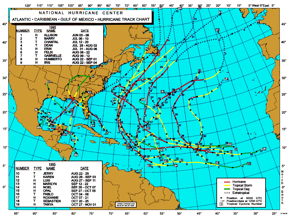
Looks like this might be a candidate for a TS Jerry/Hurricane Erin-type scenario from (drum roll please) 1995 -- the season a lot of people have said 2005 could resemble. Not sure of the exact strength this thing may get to, nor its exact path. But a strong tropical storm crossing the FL peninsula on its way to the Gulf is entirely possible.
http://www.nhc.noaa.gov/tracks/1995atl.gif
http://www.nhc.noaa.gov/tracks/1995atl.gif
0 likes
-
Stormcenter
- S2K Supporter
- Posts: 6689
- Joined: Wed Sep 03, 2003 11:27 am
- Location: Houston, TX
Rainband wrote:It's possible. This is the tropics. Looks more like an eastern GOM threat at this point. As you know things change in the tropics.
Until this "whatever" is in the GOM it is no ones problem along GOM coastline. Now when and if it makes it into the GOM then it's becomes everyones problem along the GOM coastline. I would not put too much faith in the models at all this far out so to say it's an eastern GOM threat or any threat is really premature in my opinion.
0 likes
-
WeatherEmperor
- S2K Supporter
- Posts: 4806
- Age: 42
- Joined: Thu Sep 04, 2003 2:54 pm
- Location: South Florida
-
Rainband
I will eat my crow if need be. Just my opinion. I agree weatherboy.Stormcenter wrote:Rainband wrote:It's possible. This is the tropics. Looks more like an eastern GOM threat at this point. As you know things change in the tropics.
Until this "whatever" is in the GOM it is no ones problem along GOM coastline. Now when and if it makes it into the GOM then it's becomes everyones problem along the GOM coastline. I would not put too much faith in the models at all this far out so to say it's an eastern GOM threat or any threat is really premature in my opinion.
0 likes
-
mvtrucking

- S2K Supporter
- Posts: 698
- Age: 67
- Joined: Sat Jul 09, 2005 10:01 am
- Location: Monroe,La
Uk Met 144 hr brings a low over the southern tip of Florida on Friday & Saturday and then into the central gulf Monday(With a 990 mb pressure)Click play.(Long way out though?)
http://meteocentre.com/animate.php?lang ... 00Z%20ANIM
http://meteocentre.com/animate.php?lang ... 00Z%20ANIM
Last edited by mvtrucking on Tue Aug 23, 2005 8:37 am, edited 1 time in total.
0 likes
-
storms in NC

- S2K Supporter
- Posts: 2338
- Joined: Thu Jul 28, 2005 2:58 pm
- Location: Wallace,NC 40 miles NE of Wilm
- Contact:
Who is online
Users browsing this forum: No registered users and 236 guests