 The posts in this forum are NOT official forecast and should not be used as such. They are just the opinion of the poster and may or may not be backed by sound meteorological data. They are NOT endorsed by any professional institution or

Baltimore: +6.4°; 0.02”
Boston: +3.0°; 0.91”
New York City: +5.8°; 0.39”
Newark: +5.3°; 0.43”
Norfolk: +4.9°; 0.26”
Philadelphia: +5.7°; 0.35”
Providence: +3.8°; 1.01”
Richmond: +8.1°; 0.10”
Washington, DC: +5.6°; 0.06”
However, this period of exceptional warmth and low precipitation is now coming to an end. Today’s passage of a sharp cold front with possible severe weather in parts of the East should mark the beginning of the transition.
At this point in time, there is sufficient and growing evidence that a colder and possible stormier regime could be taking hold.
MJO Phases:
Currently, the MJO is in Phase 6. It is weak. Nonetheless, the brief sharp drop in the SOI to -18.70 may have hinted that it could be of sufficient strength so that the typical correlations with regard to Phases 8, 1 and 2 may hold.
Phase 8, which will likely begin within 5-10 days typically sees blocking develop and a trough in the eastern United States:

NAO:
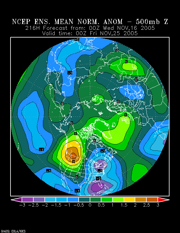
The NCEP ensemble mean 500 mb anomalies point to the development of a strong block within the timeframe suggested by the MJO:
Moreover, the ensemble forecasts for both the Arctic Oscillation and NAO suggest that the closing days of November should see negative to strongly negative readings for both indices. In general, in 70% of the cases where the Arctic Oscillation has averaged negative in November or December, the NAO was negative.
As a result, given the MJO correlation, ensemble data, and historic relationship, I have good confidence that the NAO will, in fact, be negative to close November.
NCEP Ensembles:
These depict the development of a strong trough in the East—peaking at 3 standard deviations below normal off the Southeast—by November 27-28 0z. Of perhaps even greater interest is the prolonged period of above normal height anomalies that are linked across North America for several days. Often, when such a setup has occurred, Arctic outbreaks have followed shortly thereafter. One prominent outbreak was the extreme late November cold of 1976.
Initially, one should not expect extreme cold. Probably, November will end with temperatures averaging below normal. The most recent 10-day forecast normalized anomalies for Canada depict below normal readings for northern and eastern Canada. In eastern Canada, temperatures are forecast to be approximately 0.5 to 0.75 standard deviations (each unit on the map is 0.43 standard deviations) below normal. So, a decent cold shot would be possible even before November ends.
All said, here’s what I expect over the next 10-20 days:
∙ A return to storminess in the East.
∙ First freeze, perhaps as far south as Washington, DC, in the November 20-30 timeframe. Boston and Providence might see at least one low below 30° before the end of the month.
∙ November 20-30 averages somewhat below normal from Philadelphia to Boston.
∙ December 1-10 averages below normal to perhaps much below normal from Richmond to Boston.
∙ Possible major storm in the period beginning near Thanksgiving Day to around December 5. Per Heather Archambeault’s research, there may be an ensemble signal for such an event.
∙ At least one event prior to November 30 where rain ends as snow in coastal sections of the East, particularly from Philadelphia north and eastward. If December were to see 10” or more snow in Central Park following some November snowfall, that could be a strong signal that NYC would be headed for another winter with 30” or more snowfall. Philadelphia to Boston should receive at least a trace of snow before November is finished.
∙ Growing risk of a significant Arctic outbreak during the first week of December.


