Pattern Change Appears Imminent

Winter Weather Discussion

Moderator: S2k Moderators

Forum rules

The posts in this forum are NOT official forecast and should not be used as such. They are just the opinion of the poster and may or may not be backed by sound meteorological data. They are NOT endorsed by any professional institution or STORM2K.

Help Support Storm2K
Message
Author
donsutherland1
S2K Analyst
S2K Analyst
Posts: 2718
Joined: Mon Sep 15, 2003 8:49 pm
Location: New York

Pattern Change Appears Imminent

#1 Postby donsutherland1 » Wed Nov 16, 2005 9:39 am

To date, November has been unseasonably warm and dry in the Mid-Atlantic and Northeastern United States. Select temperature anomalies and precipitation for the November 1-15 period follow:

Baltimore: +6.4°; 0.02”
Boston: +3.0°; 0.91”
New York City: +5.8°; 0.39”
Newark: +5.3°; 0.43”
Norfolk: +4.9°; 0.26”
Philadelphia: +5.7°; 0.35”
Providence: +3.8°; 1.01”
Richmond: +8.1°; 0.10”
Washington, DC: +5.6°; 0.06”

However, this period of exceptional warmth and low precipitation is now coming to an end. Today’s passage of a sharp cold front with possible severe weather in parts of the East should mark the beginning of the transition.

At this point in time, there is sufficient and growing evidence that a colder and possible stormier regime could be taking hold.

MJO Phases:
Currently, the MJO is in Phase 6. It is weak. Nonetheless, the brief sharp drop in the SOI to -18.70 may have hinted that it could be of sufficient strength so that the typical correlations with regard to Phases 8, 1 and 2 may hold.

Phase 8, which will likely begin within 5-10 days typically sees blocking develop and a trough in the eastern United States:

Image

NAO:
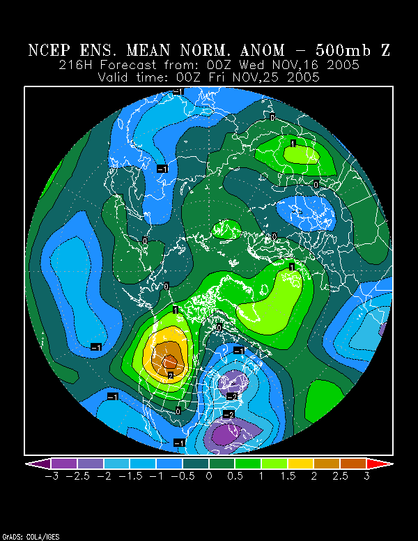
The NCEP ensemble mean 500 mb anomalies point to the development of a strong block within the timeframe suggested by the MJO:
Image

Moreover, the ensemble forecasts for both the Arctic Oscillation and NAO suggest that the closing days of November should see negative to strongly negative readings for both indices. In general, in 70% of the cases where the Arctic Oscillation has averaged negative in November or December, the NAO was negative.

As a result, given the MJO correlation, ensemble data, and historic relationship, I have good confidence that the NAO will, in fact, be negative to close November.

NCEP Ensembles:
These depict the development of a strong trough in the East—peaking at 3 standard deviations below normal off the Southeast—by November 27-28 0z. Of perhaps even greater interest is the prolonged period of above normal height anomalies that are linked across North America for several days. Often, when such a setup has occurred, Arctic outbreaks have followed shortly thereafter. One prominent outbreak was the extreme late November cold of 1976.

Initially, one should not expect extreme cold. Probably, November will end with temperatures averaging below normal. The most recent 10-day forecast normalized anomalies for Canada depict below normal readings for northern and eastern Canada. In eastern Canada, temperatures are forecast to be approximately 0.5 to 0.75 standard deviations (each unit on the map is 0.43 standard deviations) below normal. So, a decent cold shot would be possible even before November ends.

All said, here’s what I expect over the next 10-20 days:

∙ A return to storminess in the East.
∙ First freeze, perhaps as far south as Washington, DC, in the November 20-30 timeframe. Boston and Providence might see at least one low below 30° before the end of the month.
∙ November 20-30 averages somewhat below normal from Philadelphia to Boston.
∙ December 1-10 averages below normal to perhaps much below normal from Richmond to Boston.
∙ Possible major storm in the period beginning near Thanksgiving Day to around December 5. Per Heather Archambeault’s research, there may be an ensemble signal for such an event.
∙ At least one event prior to November 30 where rain ends as snow in coastal sections of the East, particularly from Philadelphia north and eastward. If December were to see 10” or more snow in Central Park following some November snowfall, that could be a strong signal that NYC would be headed for another winter with 30” or more snowfall. Philadelphia to Boston should receive at least a trace of snow before November is finished.
∙ Growing risk of a significant Arctic outbreak during the first week of December.
0 likes   

User avatar
Portastorm
Storm2k Moderator
Storm2k Moderator
Posts: 9914
Age: 63
Joined: Fri Jul 11, 2003 9:16 am
Location: Round Rock, TX
Contact:

#2 Postby Portastorm » Wed Nov 16, 2005 2:07 pm

Don,

As always, I am impressed by your cogent analyses and thankful that you share them with us! So ... many thanks!

Do you have any thoughts on what this pattern change will mean for the Southern Plains?

Michael
0 likes   

User avatar
carve
Tropical Storm
Tropical Storm
Posts: 224
Joined: Sun Jan 09, 2005 5:49 pm
Location: east central ohio

#3 Postby carve » Wed Nov 16, 2005 2:25 pm

Great stuff Don...what do you see in all of this for central ohio.I have seen accuweathers 90 day outlook and they are calling for below nomal temps and normal snowfall.
0 likes   

donsutherland1
S2K Analyst
S2K Analyst
Posts: 2718
Joined: Mon Sep 15, 2003 8:49 pm
Location: New York

#4 Postby donsutherland1 » Wed Nov 16, 2005 3:05 pm

Portastorm,

Right now, I'm thinking that the November 20-December 10 period could feature changeable weather for the southern Plains with the possibility of an Arctic intrusion early in December but also some spells of above normal readings.
0 likes   

donsutherland1
S2K Analyst
S2K Analyst
Posts: 2718
Joined: Mon Sep 15, 2003 8:49 pm
Location: New York

#5 Postby donsutherland1 » Wed Nov 16, 2005 3:07 pm

Carve,

The pattern change should also hold true for central Ohio. Into early December, I believe readings should be below normal there once the pattern change has occurred.
0 likes   

User avatar
mike815
Category 5
Category 5
Posts: 1460
Joined: Fri Jul 22, 2005 8:21 am
Location: palm bay fl

#6 Postby mike815 » Wed Nov 16, 2005 4:00 pm

hmm. will it remain below average because a good chuck of the us is forecasted to be above normal in temp this winter.
0 likes   

User avatar
Stephanie
S2K Supporter
S2K Supporter
Posts: 23843
Age: 63
Joined: Thu Feb 06, 2003 9:53 am
Location: Glassboro, NJ

#7 Postby Stephanie » Wed Nov 16, 2005 4:30 pm

I'll get more in the mood for Christmas with the colder weather. It's been a jopy the last two weekends to get outside and rake in the warm air.
0 likes   

User avatar
cctxhurricanewatcher
Category 5
Category 5
Posts: 1206
Joined: Sun Sep 12, 2004 8:53 pm
Location: Corpus Christi, Texas

#8 Postby cctxhurricanewatcher » Wed Nov 16, 2005 5:11 pm

For what it's worth. Bastardi see some shades of Dec 1989 coming around and for us down here in Texas, it was one of the coldest Decembers on record which was capped by the pre Christmas record breaking cold snap. Personally I'd like to see another frozen precip record breaking event again this December. That was a ton of fun for all last Christmans. :froze:
0 likes   

User avatar
vbhoutex
Storm2k Executive
Storm2k Executive
Posts: 29112
Age: 73
Joined: Wed Oct 09, 2002 11:31 pm
Location: Cypress, TX
Contact:

#9 Postby vbhoutex » Wed Nov 16, 2005 5:25 pm

Yep, December 1989 was WAY COLD!!!!!

You guys in CC got a lot more snow than we did in Houston proper this past winter!!!!!
0 likes   

User avatar
PTrackerLA
Category 5
Category 5
Posts: 5277
Age: 41
Joined: Thu Oct 10, 2002 8:40 pm
Location: Lafayette, LA

#10 Postby PTrackerLA » Wed Nov 16, 2005 5:41 pm

It appears as if we'll be staying fairly cool until next week with another front coming through. This was an interesting forecast discussion from NWS New Orleans this morning regarding the big changes.

AREA FORECAST DISCUSSION
NATIONAL WEATHER SERVICE NEW ORLEANS LA
359 AM CST WED NOV 16 2005

.DISCUSSION...
THE ANTICIPATED COLD FRONT HAS SINCE MOVED THROUGH THE FORECAST
AREA WITH THE LEADING CONVECTION WELL EAST OF THE AREA WITH LITTLE
FANFARE. SOME OVER-RUNNING LIGHT RAIN AND CLOUDINESS WILL CONTINUE
UNTIL THE UPPER TROUGH SWINGS THROUGH LATER TODAY. GAINING
NEW FOUND RESPECT FOR THE DENSITY OF THIS COLD AIRMASS...VERY COLD
CONSIDERING ITS THE FIRST ARCTIC AIRMASS AND SO EARLY IN THE
SEASON. AN EVALUATION OF THE TELECONNECTIONS AND HEMISPHERIC
OSCILLATIONS INDICES SHOW A DISTURBING TREND OF STRONG NEGATIVE
PHASE NORTH ATLANTIC OSCILLATION TO TAKE PLACE IN THE THIS
UPCOMING WEEK. I RECALL SIMILAR HAPPENINGS IN 2003 WHEN THE NAO
DOMINATED WITH WINTER WEATHER. IF THIS IS TRUE...THEN IF FORBODES
A HARSH WINTER SEASON. THE LATEST AMPLIFYING TROUGH ON THE EASTERN
SEABOARD WILL BECOME MORE AMPLIFIED WITH FREQUENT SHORT-WAVE
PASSAGES INTO THE BASE STRAIGHT FROM CANADA. THIS WILL ONSET A
LONG PERIOD OF DRY WEATHER AND BELOW NORMAL TEMPERATURES FOR OUR
REGION.

MODEL GUIDANCE CONTINUE TO SHOW SUB-FREEZING TEMPERATURES IN THE
NORTHERN HALF OF OUR AREA FOR THURSDAY NIGHT. WILL INDICATE
TEMPERATURES RIGHT AT FREEZING AND ISSUE A FREEZE WATCH FOR ALL OF OUR
MISSISSIPPI COUNTIES AND THE ADJACENT LOUISIANA PARISHES. THIS
SHOULD BE JUST A LIGHT FREEZE THIS GO-ROUND BUT THE PATTERN WOULD
SUGGEST A HARDER FREEZE MAY BE IN THE WORKS LATER IN THE MONTH OR
VERY EARLY DECEMBER.
0 likes   

User avatar
WhiteShirt
Tropical Storm
Tropical Storm
Posts: 121
Joined: Fri Sep 10, 2004 10:34 pm
Location: upper Texas coast

#11 Postby WhiteShirt » Wed Nov 16, 2005 6:06 pm

cctxhurricanewatcher wrote:For what it's worth. Bastardi see some shades of Dec 1989 coming around and for us down here in Texas, it was one of the coldest Decembers on record which was capped by the pre Christmas record breaking cold snap. Personally I'd like to see another frozen precip record breaking event again this December. That was a ton of fun for all last Christmans. :froze:


Is this for December or this month?
0 likes   

User avatar
azsnowman
Category 5
Category 5
Posts: 8591
Joined: Wed Feb 05, 2003 8:56 pm
Location: Pinetop Arizona. Elevation 7102' (54 miles west of NM border)

#12 Postby azsnowman » Wed Nov 16, 2005 10:18 pm

I'm afraid to ask BUT what the heck.........how about the Southwest, same ol' same ol'? It's been SOOOOOOOOOOOooo blasted warm, ALMOST hot!

Dennis
0 likes   

User avatar
mike815
Category 5
Category 5
Posts: 1460
Joined: Fri Jul 22, 2005 8:21 am
Location: palm bay fl

#13 Postby mike815 » Wed Nov 16, 2005 11:03 pm

I know it has been its going to change now finially.
0 likes   

User avatar
ETXHAMXYL
Tropical Storm
Tropical Storm
Posts: 170
Joined: Tue Dec 14, 2004 9:31 pm
Location: East Texas
Contact:

#14 Postby ETXHAMXYL » Wed Nov 16, 2005 11:27 pm

Will this change give us some much needed rains here in NTX? The last rain we had worth measuring was when Rita came up and that was long ago. Texas is already a tenderbox as it is now, I can't imagine what it will be like if we have a COLD and DRY winter this year.
0 likes   

User avatar
MGC
S2K Supporter
S2K Supporter
Posts: 5899
Joined: Sun Mar 23, 2003 9:05 pm
Location: Pass Christian MS, or what is left.

#15 Postby MGC » Wed Nov 16, 2005 11:51 pm

Noooo, not the dreaded -NAO! Don't even mention the December 1989 freeze, I never want to experience that again.....MGC
0 likes   

User avatar
boca
Category 5
Category 5
Posts: 6367
Age: 60
Joined: Mon Dec 15, 2003 8:49 am
Location: Boca Raton,FL

#16 Postby boca » Thu Nov 17, 2005 8:47 am

MGC I remember Dec 89 when here in S FL all the trees went into shock and all the leaves came off the trees and temps were in the 20's.
0 likes   

User avatar
CaptinCrunch
S2K Supporter
S2K Supporter
Posts: 8728
Age: 57
Joined: Mon Nov 03, 2003 4:33 pm
Location: Kennedale, TX (Tarrant Co.)

#17 Postby CaptinCrunch » Thu Nov 17, 2005 9:26 am

The last sub-zero reading here in D/FW was December 23, 1989 when we hit -1 on a clear dry night. It is tied for 3rd on the coldest reading recorded since 1899, and Dec 22, 1989 is 9th on that list with a recorded low of 3 degrees. As a matter of fact that whole week leading up to Christmas we had lows in the lower teens and single digits readings with highs between 27 & 32 degrees. The coldest December on record is a tie between December 89, and 63 with 21 recorded freezes.

How ever January 1990 avg above normal and February was just avg.

FYI. The top two coldest readings recorded in D/FW since records have been kept (1899)

1. -8 on Feb 12, 1899, Clear, 1" snow cover
2. -2 on Jan 31, 1949, Heavy Fog, 3" snow cover
0 likes   

Steve H.
Category 5
Category 5
Posts: 2146
Joined: Sat Oct 19, 2002 9:06 am
Location: Palm Bay, Florida

#18 Postby Steve H. » Thu Nov 17, 2005 12:09 pm

Hey, is anyone famliar with Vermont winters? I'm going up to Smuggler's Notch VT, about an hour outside of Burlington, to go skiing there. The trip is planned for Jan. 4th - Jan. 11th. Is there a deecent chance I'll have snow on the ground there during that period? New England can get funny sometimes and rain at higher elevations too. Not like out west. Anyone been there before? Thoughts appreciated. 8-)
0 likes   

donsutherland1
S2K Analyst
S2K Analyst
Posts: 2718
Joined: Mon Sep 15, 2003 8:49 pm
Location: New York

Re: Pattern Change Appears Imminent

#19 Postby donsutherland1 » Fri Nov 18, 2005 12:02 am

Per the 11/18 0z runs of the GFS and GGEM--without placing too much emphasis on the model details right now--I'm still liking the idea of at least one event prior to November 30 where rain ends as snow in coastal sections of the East, particularly from Philadelphia north and eastward.

Perhaps, should the heights crash as depicted on the most recent run of the GFS with cold air pouring into the storm's circulation before the precipitation cuts off, the pre-Thanksgiving event might be a reasonable candidate for such a scenario. Any accumulations in the big cities would be minor (trace to coating?) if they occur. Another candidate might be a possible system on or just after Thanksgiving Day, which the GFS blows up to 992 mb in the Gulf of Maine.

Later, the final days of November might see temporary moderation, but the cold should return during the first week in December. As that week advances, I believe that the risk of an Arctic outbreak could be growing. Right now, beyond 240 hours I place greater weight on the NCEP ensemble mean than the operational GFS, with the assumption that blocking could be developing.
0 likes   

User avatar
wxwatcher91
Category 5
Category 5
Posts: 1606
Joined: Wed Jul 06, 2005 2:43 pm
Location: Keene, NH
Contact:

#20 Postby wxwatcher91 » Fri Nov 18, 2005 7:03 am

000
FXUS61 KBOX 181010 AAA
AFDBOX

AREA FORECAST DISCUSSION..PROBABLE FINAL..
NATIONAL WEATHER SERVICE TAUNTON MA
508 AM EST FRI NOV 18 2005


.LONG TERM (SUNDAY THROUGH THURSDAY)...
FOR SUNDAY...HIGH PRESSURE SAGS SOUTH AND WEAKENS WHILE A WEAK COLD
FRONT LIFTS NORTH ACROSS NORTHERN NEW ENGLAND. SOUTHWESTERLY WINDS
TURN WESTERLY IN THE AFTERNOON CAUSING MODERATING TEMPERATURES IN
THE AFTERNOON FROM A COLD START. HIGHS RISE INTO THE UPPER 40S TO
MID 50S ACROSS THE REGION WHICH IS RIGHT WITHIN SEASONAL NORMS.

AFTER SUNDAY...MODELS STILL OFFERING DIFFERING SOLUTIONS AS TO
EVOLUTION OF COASTAL STORM OFF SE COAST EARLY NEXT WEEK. DIFFERING
TIMING AND PLACEMENT SCENARIOS CONTINUE TO ABOUND. 18/00Z GFS NOW
SHOWING AN INSIDE RUNNER...WHILE UKMET...CANADIAN AND ECMWF OFFER AN
OFFSHORE TRACK...TAKING SYSTEM OVER GULF OF MAINE LATE DAY TUESDAY.
THE MAJORITY MODEL SUITE FAVORING WHAT HPC HAD DEPICTED
EARLIER...ONLY CURRENT SUITE STRONGER WITH SYSTEM. FOR
NOW...EXTENDED FORECAST FROM MONDAY ONWARDS IS BASED ON CONTINUITY.
CHANGES WERE MADE HOWEVER TO INCREASE THE WIND SPEEDS OVER COASTAL
WATERS. SYSTEM TO BRING MAINLY RAIN TO SE SECTIONS WITH A MIXED
EVENT INTERIOR.

WITH POSITIVE PACIFIC NORTH AMERICAN IN PLACE...AND THE NORTH
ATLANTIC OSCILLATION STARTS GOING NEGATIVE 00Z WEDNESDAY AND
THEREAFTER...MEANING UPPER RIDGE BUILDS OVER GREENLAND. UPPER RIDGE
BUILDING DOWNSTREAM CAUSES LONG WAVE TROUGH TO CARVE DEEPER OVER
NATIONS EAST. SO EXPECT UNSETTLED WEATHER AND MORE COLD AIR TO
INFILTRATE THE REGION THROUGH WEEKS END.
0 likes   


Return to “Winter Weather”

Who is online

Users browsing this forum: No registered users and 21 guests