95L C Atlantic,Comments,Sat Pics,Models Thread

This is the general tropical discussion area. Anyone can take their shot at predicting a storms path.

Moderator: S2k Moderators

Forum rules

The posts in this forum are NOT official forecasts and should not be used as such. They are just the opinion of the poster and may or may not be backed by sound meteorological data. They are NOT endorsed by any professional institution or STORM2K. For official information, please refer to products from the National Hurricane Center and National Weather Service.

Help Support Storm2K
Message
Author
Coredesat

#121 Postby Coredesat » Mon Nov 21, 2005 11:21 pm

Image

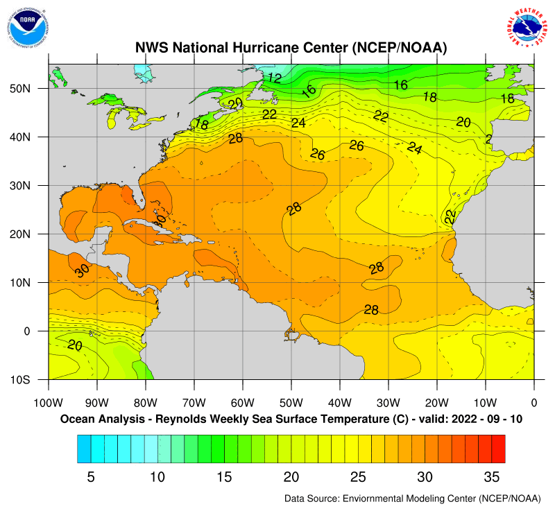
It is REALLY trying to become tropical, but it probably won't. Its window for tropical transition is starting to close. It's approaching the 24C isotherm. Unless this is another Vince, it probably has a day or so.
0 likes   

Matt-hurricanewatcher

#122 Postby Matt-hurricanewatcher » Tue Nov 22, 2005 1:16 am

The convection is starting to decrease near the center. In forming into a comma to the north/northeast of the center. This will not become Delta...
0 likes   

User avatar
JamesFromMaine2
Category 4
Category 4
Posts: 989
Joined: Tue Jul 19, 2005 1:38 am
Location: Portland Maine USA
Contact:

#123 Postby JamesFromMaine2 » Tue Nov 22, 2005 1:22 am

Matt-hurricanewatcher wrote:The convection is starting to decrease near the center. In forming into a comma to the north/northeast of the center. This will not become Delta...


You maybe right However I wouldn't say that just yet! alot can happen in just a short amount of time!
0 likes   

User avatar
JamesFromMaine2
Category 4
Category 4
Posts: 989
Joined: Tue Jul 19, 2005 1:38 am
Location: Portland Maine USA
Contact:

#124 Postby JamesFromMaine2 » Tue Nov 22, 2005 6:02 am

000
ABNT20 KNHC 221010
TWOAT
TROPICAL WEATHER OUTLOOK
NWS TPC/NATIONAL HURRICANE CENTER MIAMI FL
530 AM EST TUE NOV 22 2005

FOR THE NORTH ATLANTIC...CARIBBEAN SEA AND THE GULF OF MEXICO...

A LARGE NON-TROPICAL LOW PRESSURE SYSTEM LOCATED OVER THE CENTRAL
ATLANTIC...ABOUT 950 MILES WEST-SOUTHWEST OF THE AZORES ISLANDS...
CONTINUES TO SHOW SIGNS OF ORGANIZATION. ALTHOUGH UPPER-LEVEL
WINDS ARE NOT VERY FAVORABLE FOR DEVELOPMENT...THIS SYSTEM STILL
HAS THE POTENTIAL TO ACQUIRE TROPICAL CHARACTERISTICS DURING
THE NEXT DAY OR TWO. ADDITIONAL INFORMATION ON THIS SYSTEM CAN
BE FOUND IN HIGH SEAS FORECASTS ISSUED BY THE NATIONAL WEATHER
SERVICE...UNDER AWIPS HEADER NFDHSFAT1 AND WMO HEADER FZNT01 KWBC.

ELSEWHERE...TROPICAL STORM FORMATION IS NOT EXPECTED THROUGH
WEDNESDAY.

FORECASTER PASCH

$$
0 likes   

User avatar
HURAKAN
Professional-Met
Professional-Met
Posts: 46086
Age: 38
Joined: Thu May 20, 2004 4:34 pm
Location: Key West, FL
Contact:

#125 Postby HURAKAN » Tue Nov 22, 2005 7:29 am

Image

The storm should begin to move southward, this should help on its possible subtropical or tropical development.
0 likes   

User avatar
TS Zack
Category 4
Category 4
Posts: 925
Joined: Thu Jul 01, 2004 6:23 pm
Location: Louisiana
Contact:

#126 Postby TS Zack » Tue Nov 22, 2005 7:36 am

It probably won't move any further Southward. It will just stall out and then get picked-up by the incoming trough off the East Coast.
0 likes   

User avatar
HURAKAN
Professional-Met
Professional-Met
Posts: 46086
Age: 38
Joined: Thu May 20, 2004 4:34 pm
Location: Key West, FL
Contact:

#127 Postby HURAKAN » Tue Nov 22, 2005 8:36 am

22/1145 UTC 31.3N 39.9W ST2.5/2.5 95 -- Atlantic Ocean


NOW WE HAVE A SUBTROPICAL SYSTEM ACCORDING TO DVORAK.
0 likes   

User avatar
cjrciadt
S2K Supporter
S2K Supporter
Posts: 1616
Joined: Mon Aug 22, 2005 1:11 pm
Location: Kissimmee, FL

#128 Postby cjrciadt » Tue Nov 22, 2005 8:42 am

Image
Subtropical Delta? Huh?
Image
0 likes   

Weatherfreak000

#129 Postby Weatherfreak000 » Tue Nov 22, 2005 9:05 am

Matt-hurricanewatcher wrote:The convection is starting to decrease near the center. In forming into a comma to the north/northeast of the center. This will not become Delta...


Stop downtalking the system EVERY SINGLE TIME YOU POST.

It's getting annoying.
0 likes   

User avatar
Downdraft
S2K Supporter
S2K Supporter
Posts: 906
Joined: Wed Oct 09, 2002 8:45 pm
Location: Sanford, Florida
Contact:

#130 Postby Downdraft » Tue Nov 22, 2005 9:14 am

Weatherfreak000 wrote:
Matt-hurricanewatcher wrote:The convection is starting to decrease near the center. In forming into a comma to the north/northeast of the center. This will not become Delta...


Stop downtalking the system EVERY SINGLE TIME YOU POST.

It's getting annoying.


In this forum when your either positive or negative on a system you have a right to say so. It's one thing to debate an outlook it's another to criticize simply because you personally don't like the statement.
0 likes   

flhurricaneguy
Tropical Storm
Tropical Storm
Posts: 197
Joined: Mon Sep 26, 2005 10:21 am

#131 Postby flhurricaneguy » Tue Nov 22, 2005 9:33 am

stop arguing like little girls
0 likes   

User avatar
cjrciadt
S2K Supporter
S2K Supporter
Posts: 1616
Joined: Mon Aug 22, 2005 1:11 pm
Location: Kissimmee, FL

#132 Postby cjrciadt » Tue Nov 22, 2005 9:34 am

senorpepr,, what do you think of 95L?
0 likes   

User avatar
senorpepr
Military Met/Moderator
Posts: 12542
Age: 43
Joined: Fri Aug 22, 2003 9:22 pm
Location: Mackenbach, Germany
Contact:

#133 Postby senorpepr » Tue Nov 22, 2005 9:47 am

cjrciadt wrote:senorpepr,, what do you think of 95L?
I'm more impressed with this than I was a couple of days ago. It really seems to be getting it's act together. I would say a "fair" chance at becoming Subtropical Storm Delta within the next 48 hours. Regardless of making subtropical or tropical transition, it will still be a strong gale for shipping interests.
0 likes   

User avatar
jusforsean
Category 1
Category 1
Posts: 395
Joined: Wed Nov 09, 2005 8:22 am
Location: South Florida

#134 Postby jusforsean » Tue Nov 22, 2005 9:50 am

where exactly do the models have this thing going?
0 likes   

User avatar
senorpepr
Military Met/Moderator
Posts: 12542
Age: 43
Joined: Fri Aug 22, 2003 9:22 pm
Location: Mackenbach, Germany
Contact:

#135 Postby senorpepr » Tue Nov 22, 2005 10:01 am

jusforsean wrote:where exactly do the models have this thing going?
Looks like they want to take it slightly southward until the trough along the East Coast picks it up. At that time, it will head toward SE Europe.
0 likes   

Forecaster Colby

#136 Postby Forecaster Colby » Tue Nov 22, 2005 11:21 am

NOW they call it subtropical?

???? It's organized, but not even sort of tropical now.
0 likes   

Rainband

#137 Postby Rainband » Tue Nov 22, 2005 11:23 am

Weatherfreak000 wrote:
Matt-hurricanewatcher wrote:The convection is starting to decrease near the center. In forming into a comma to the north/northeast of the center. This will not become Delta...


Stop downtalking the system EVERY SINGLE TIME YOU POST.

It's getting annoying.
Opinions are that of the poster and they are entitled to them.
0 likes   

User avatar
HURAKAN
Professional-Met
Professional-Met
Posts: 46086
Age: 38
Joined: Thu May 20, 2004 4:34 pm
Location: Key West, FL
Contact:

#138 Postby HURAKAN » Tue Nov 22, 2005 11:24 am

11:30 AM EDT TWO:

a strong and large non-tropical low pressure system over the central
Atlantic centered about 900 miles west-southwest of the Azores
Islands is moving little. This system is gradually acquiring
tropical characteristics and could become a tropical storm at any
time. Additional information on this system can be found in high
seas forecasts issued by the National Weather Service...under AWIPS
header nfdhsfat1 and WMO header fznt01 kwbc.


TROPICAL STORM DELTA COULD FORM ANYTIME!!!
0 likes   

Forecaster Colby

#139 Postby Forecaster Colby » Tue Nov 22, 2005 11:26 am

How is that subtropical? No deep convection within a parsec of the center...
0 likes   

User avatar
cjrciadt
S2K Supporter
S2K Supporter
Posts: 1616
Joined: Mon Aug 22, 2005 1:11 pm
Location: Kissimmee, FL

#140 Postby cjrciadt » Tue Nov 22, 2005 11:27 am

Image
Lots of interesting pics on the NRL site.
0 likes   


Return to “Talkin' Tropics”

Who is online

Users browsing this forum: kevin, Ulf and 75 guests