Historic outbreak Sunday: The aftermath

U.S. & Caribbean Weather Discussions and Severe Weather Events

Moderator: S2k Moderators

Forum rules

The posts in this forum are NOT official forecast and should not be used as such. They are just the opinion of the poster and may or may not be backed by sound meteorological data. They are NOT endorsed by any professional institution or STORM2K.

Help Support Storm2K
Message
Author
jhamps10

#41 Postby jhamps10 » Sun Mar 05, 2006 12:30 am

jkt21787 wrote:All areas in particularly MS, AL, TN, KY, but also in portions of TX, LA, AR, MO, and GA, possibly IL and IN too, need to be on guard now. The first group of states now appears at most risk for a significant event based on latest data, and I see nothing unfortunately to lessen the severe threat in those areas at all at this time. No reason to change the title of this thread yet. :wink:


Completely agreeing with you on that note jkt . Besides we are STILL 4-5 days out right now, forcast models WILL change, and this still looks like a really major severe weather outbreak setting up for mid-late week.
0 likes   

jhamps10

#42 Postby jhamps10 » Sun Mar 05, 2006 12:33 am

Espically from looking at 120 Ark, MO, IL, IN, KY, TN really needs to stay on HIGH alert here.

http://www.nco.ncep.noaa.gov/pmb/nwprod ... p_120m.gif
0 likes   

User avatar
Extremeweatherguy
Category 5
Category 5
Posts: 11095
Joined: Mon Oct 10, 2005 8:13 pm
Location: Florida

#43 Postby Extremeweatherguy » Sun Mar 05, 2006 12:39 am

Things are going to get quite interesting..
0 likes   

User avatar
therock1811
Category 5
Category 5
Posts: 5163
Age: 39
Joined: Thu May 15, 2003 2:15 pm
Location: Kentucky
Contact:

#44 Postby therock1811 » Sun Mar 05, 2006 2:00 am

vbhoutex wrote:EVERYONE POSTING MAPS AND PREDICTIONS PLEASE READ MY ANNOUNCEMENT AT THE TOP OF THIS FORUM!!!


I didn't forget. It's there on mine.
0 likes   

User avatar
wxman22
Category 5
Category 5
Posts: 1493
Joined: Mon Jan 30, 2006 12:39 am
Location: Wichita Falls, TX
Contact:

#45 Postby wxman22 » Sun Mar 05, 2006 4:21 am

Heres my latest severe wx forcast:

Image
0 likes   

User avatar
wxman22
Category 5
Category 5
Posts: 1493
Joined: Mon Jan 30, 2006 12:39 am
Location: Wichita Falls, TX
Contact:

#46 Postby wxman22 » Sun Mar 05, 2006 5:46 am

Seems like each run of the GFS gets a little bit more aggresive for us in Southeast Texas:


Image


Image
0 likes   

User avatar
drezee
S2K Supporter
S2K Supporter
Posts: 3664
Joined: Mon Jun 09, 2003 12:49 pm
Location: FL

#47 Postby drezee » Sun Mar 05, 2006 10:23 am

GFS:

http://www.nco.ncep.noaa.gov/pmb/nwprod ... _114.shtml

http://www.nco.ncep.noaa.gov/pmb/nwprod ... _120.shtml

Euro:

http://www.meteo.psu.edu/~gadomski/ECMWF_0z/f120.gif

NOGAPS:

http://www.meteo.psu.edu/~gadomski/NOGAPS_0z/f120.gif

CMC:

http://www.meteo.psu.edu/~gadomski/CMC_0z/f120.gif

Check the links above for guidance:

500MB winds and up: SW
850MB winds: S
10 M winds: SE

With no convvection over S MS or S AL to still the moisture or disrupt (which has killed a number of potential outbreaks), this is looking to be a serious outbreak for someone. I am not willing to nail it down yet.

The DGEX has a 500MB max spinning through the N half of the MS/AL from 00Z to 06z 3/10. The ECMWF and NOGAPS are definitely on board! The CMC bundles the energy to the N and sends a squall line through. The GFS forecasted CAPES are very low (<500). It does have 70kts of shear from surface to 6km though(N AL). Current Thinking for SE only, biggest risk would be from New Orleans to Birmingham to Nashville to Springfiled and Texarkana and back to the NO.

The following post is NOT an official forecast and should not be used as such. It is just the opinion of the poster and may or may not be backed by sound meteorological data. It is NOT endorsed by any professional institution including storm2k.org For Official Information please refer to the NHC and NWS products.
0 likes   

User avatar
Extremeweatherguy
Category 5
Category 5
Posts: 11095
Joined: Mon Oct 10, 2005 8:13 pm
Location: Florida

#48 Postby Extremeweatherguy » Sun Mar 05, 2006 11:19 am

Image

DAY 4-8 CONVECTIVE OUTLOOK
NWS STORM PREDICTION CENTER NORMAN OK
0329 AM CST SUN MAR 05 2006

VALID 081200Z - 131200Z

...DISCUSSION...
MODELS REMAIN SIMILAR THROUGH DAY 5 OR SO REGARDING LARGE-SCALE
PATTERN EVOLUTION...WHICH INCLUDES THE TRANSITION TO A MEAN
LONG-WAVE TROUGH OVER THE WRN U.S. AND A RIDGE OVER THE ERN CONUS.

MODELS DEPICT A SHORT-WAVE TROUGH MOVING EWD ACROSS THE SRN PLAINS
LATE WEDNESDAY (DAY 4) THROUGH THURSDAY EVENING...AND THEN NEWD
ACROSS THE MS/OH/TN VALLEYS FROM THURSDAY EVENING THROUGH FRIDAY
MORNING...AS HAS BEEN DEPICTED BY THE LAST SEVERAL MODEL RUNS. WITH
AN OPEN GULF FORECAST FOR SEVERAL DAYS PRIOR TO THE PASSAGE OF THIS
FEATURE...MOIST/UNSTABLE AIRMASS WILL LIKELY BE IN PLACE. THIS
COMBINED WITH STRONG WIND FIELD ASSOCIATED WITH THE UPPER FEATURE
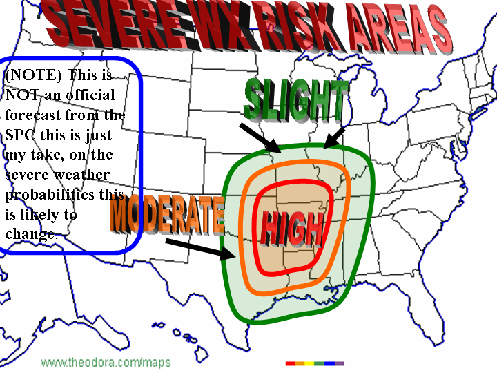
SUGGEST A SEVERE EPISODE FROM THE SRN PLAINS EWD/NEWD INTO THE TN/OH
VALLEYS FROM LATE DAY 4 THROUGH DAY 5.

THREAT BECOMES MORE UNCLEAR BEYOND DAY 5...WHEN MODELS DIVERGE
SOMEWHAT...THOUGH THEY REMAIN CONSISTENT IN DEPICTING A VERY LARGE
TROUGH EVOLVING OVER THE WRN CONUS AND PERHAPS INTO THE CENTRAL
CONUS. WITH BROAD AREA OF SWLY FLOW ALOFT AND REPEATED EPISODES OF
CYCLOGENESIS IN LEE OF THE ROCKIES...SUFFICIENT MOISTURE/INSTABILITY
AND FAVORABLY STRONG FLOW SHOULD PERSIST FROM ROUGHLY THE PLAINS EWD
TO THE APPALACHIANS FOR ADDITIONAL -- BUT DIFFICULT TO PINPOINT --
SEVERE WEATHER EVENTS THROUGH THE END OF THE PERIOD.

..GOSS.. 03/05/2006
0 likes   

User avatar
Extremeweatherguy
Category 5
Category 5
Posts: 11095
Joined: Mon Oct 10, 2005 8:13 pm
Location: Florida

#49 Postby Extremeweatherguy » Sun Mar 05, 2006 11:21 am

I am predicting that the models are slightly too fast with the first system...and instead of a Wednesday night/Thursday morning and early afternoon weather maker here in Houston..I am going to predict that the worst comes during the afternoon and evening of Thursday. We'll see though...this is still 4 days out...
0 likes   

User avatar
TexasStooge
Category 5
Category 5
Posts: 38127
Joined: Tue Mar 25, 2003 1:22 pm
Location: Irving (Dallas County), TX
Contact:

#50 Postby TexasStooge » Sun Mar 05, 2006 11:21 am

I just hope the Dallas area doesn't get that "Killer tornado".
0 likes   
Weather Enthusiast since 1991.
- Facebook
- Twitter

conestogo_flood
Category 5
Category 5
Posts: 1268
Joined: Wed Sep 28, 2005 5:49 pm

#51 Postby conestogo_flood » Sun Mar 05, 2006 1:23 pm

How important might this be?

This is likely to occur during school days right? Well, aren't state wide tornado drills after this potential outbreak?

Might the schools be "unprepared" in the event of a tornado out of this?

Maybe some parents could contact their childrens schools and advise them about this?

I don't know the American set-up for these situations, all I know is Ontario schools usually do the first day of April, long before any severe weather.

I just don't want to hear about school injuries. though with or without a tornado drill, can't always be stopped.
0 likes   

User avatar
Beam
Category 1
Category 1
Posts: 292
Joined: Fri Aug 19, 2005 2:06 pm

#52 Postby Beam » Sun Mar 05, 2006 3:03 pm

The following post is NOT an official forecast and should not be used as such. It is just the opinion of the poster and may or may not be backed by sound meteorological data. It is NOT endorsed by any professional institution including storm2k.org For Official Information please refer to the SPC and NWS products.


Image
0 likes   

jhamps10

#53 Postby jhamps10 » Sun Mar 05, 2006 3:10 pm

gee, in my opinion right now, EVERYONE from IL, IA, IN south to the Gulf really NEEDS to keep a very serious eye on the weather right now, I'm getting a sick feeling that this could be a storm that we remember for years and years...... :eek: :eek: I am going to be making a map of what areas really need to keep on guard for dangerous torandoes. stay tuned for that.
0 likes   

User avatar
WaitingForSiren
Category 1
Category 1
Posts: 383
Joined: Sun Jan 08, 2006 12:58 pm
Location: Minneapolis,Minnesota
Contact:

#54 Postby WaitingForSiren » Sun Mar 05, 2006 3:22 pm

The following post is NOT an official forecast and should not be used as such. It is just the opinion of the poster and may or may not be backed by sound meteorological data. It is NOT endorsed by any professional institution including storm2k.org For Official Information please refer to the SPC and NWS products.

Okay, I have decided to go ahead and make two completely different graphics regarding the event. I have left out Friday since theres still way too much lack of confidence with Fridays threat level. So, here they are:

Image
Image

Note how Thursday might require an upgrade for high (from me at least). I have lost confidence in Thursday as the models are in disarray compared to how they were a couple of days ago. Wednesday is looking more active than earlier expected with one strong shortwave ejecting northeastward and after moisture return all day tuesday and wednesday morning a severe episode looks highly possible.
0 likes   

jhamps10

#55 Postby jhamps10 » Sun Mar 05, 2006 3:30 pm

Here is my latest risk assessment area.

Keep in mind we are still 4 days out and this very well could change. I highlight such a large area because there are so many variables to work themselves out. I am not -removed- here, and I am an ametur.

DISCLAIMER: The following post is NOT an official forecast and should not be used as such. It is just the opinion of the poster and may or may not be backed by sound meteorological data. It is NOT endorsed by any professional institution including storm2k.org For Official Information please refer to the SPC and NWS products.

Image

Any comments are welcome and are greatly appricated.
0 likes   

jhamps10

#56 Postby jhamps10 » Sun Mar 05, 2006 3:41 pm

i don't know if this has been mentioned or not, but here is a really bad timing for a radar to go down for maintence. The Kansas City radar is going to be down most of the week for repairs. Crews from Norman, OK are working on the radar this week, and it will be down.
0 likes   

User avatar
WaitingForSiren
Category 1
Category 1
Posts: 383
Joined: Sun Jan 08, 2006 12:58 pm
Location: Minneapolis,Minnesota
Contact:

#57 Postby WaitingForSiren » Sun Mar 05, 2006 3:48 pm

Yeah I read about that. That IS bad timing. Hopefully they will do something about it. Not only will it be bad for us trying to track the storms and for people who want to get an advance warning on the storms, but if theres a big supercell or something that is worth saving a radar picture of itll be bad for people who want to make an archive of past radar images or whatever.
0 likes   

User avatar
TexasStooge
Category 5
Category 5
Posts: 38127
Joined: Tue Mar 25, 2003 1:22 pm
Location: Irving (Dallas County), TX
Contact:

#58 Postby TexasStooge » Sun Mar 05, 2006 7:15 pm

jhamps10 wrote:i don't know if this has been mentioned or not, but here is a really bad timing for a radar to go down for maintence. The Kansas City radar is going to be down most of the week for repairs. Crews from Norman, OK are working on the radar this week, and it will be down.


How convenient...NOT! :roll:
0 likes   
Weather Enthusiast since 1991.
- Facebook
- Twitter

conestogo_flood
Category 5
Category 5
Posts: 1268
Joined: Wed Sep 28, 2005 5:49 pm

#59 Postby conestogo_flood » Sun Mar 05, 2006 7:19 pm

Can they turn the RADARs back on? Or will they remain offline all through this?

How many are offline? Just Kansas City and Oklahoma City?
0 likes   

User avatar
wxmann_91
Category 5
Category 5
Posts: 8013
Age: 34
Joined: Fri Jul 15, 2005 2:49 pm
Location: Southern California
Contact:

#60 Postby wxmann_91 » Sun Mar 05, 2006 7:31 pm

I personally think the severe threat is going to be mainly south and east of Kansas City.
0 likes   


Return to “USA & Caribbean Weather”

Who is online

Users browsing this forum: No registered users and 26 guests