CronkPSU wrote:caneman wrote:worried - why?
cause it starts to cut into his viewing of Argentina/Ivory Coast?

lol, kick off in 32 min.

Still at 200m.
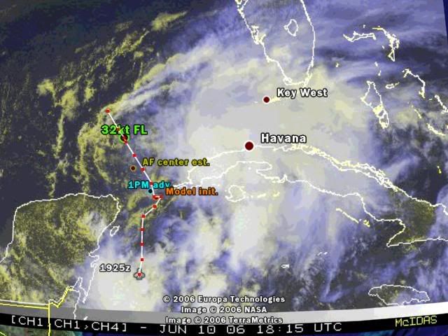
SXXX50 KNHC 101823
AF301 01AAA INVEST HDOB 17 KNHC
1816 2130N 08535W 00201 5055 141 005 250 228 005 00156 0000000000
1816. 2129N 08534W 00203 5055 170 006 250 232 007 00157 0000000000
1817 2129N 08533W 00201 5056 164 006 250 232 007 00155 0000000000
1817. 2131N 08532W 00199 5055 146 006 250 234 007 00153 0000000000
1818 2132N 08532W 00201 5055 102 006 246 234 008 00155 0000000000
1818. 2134N 08532W 00201 5056 093 007 246 232 007 00154 0000000000
1819 2135N 08532W 00201 5056 077 007 246 230 007 00155 0000000000
1819. 2137N 08532W 00202 5056 071 005 246 230 006 00155 0000000000
1820 2139N 08532W 00201 5056 068 007 242 232 007 00154 0000000000
1820. 2140N 08532W 00201 5056 081 007 246 226 007 00154 0000000000
1821 2141N 08531W 00201 5057 069 005 246 228 007 00153 0000000000
1821. 2141N 08530W 00203 5057 024 002 246 226 002 00155 0000000000
1822 2140N 08528W 00201 5057 006 002 246 228 002 00153 0000000000
1822. 2139N 08527W 00201 5057 015 001 246 228 002 00153 0000000000
1823 2138N 08526W 00202 5057 040 002 246 230 003 00154 0000000000
1823. 2137N 08525W 00201 5057 125 001 246 230 002 00153 0000000000
1824 2135N 08524W 00202 5057 140 001 246 232 002 00154 0000000000
1824. 2134N 08523W 00201 5057 206 002 246 232 002 00153 0000000000
1825 2133N 08522W 00201 5057 205 006 248 234 007 00153 0000000000
1825. 2132N 08520W 00201 5057 205 007 250 238 008 00154 0000000000