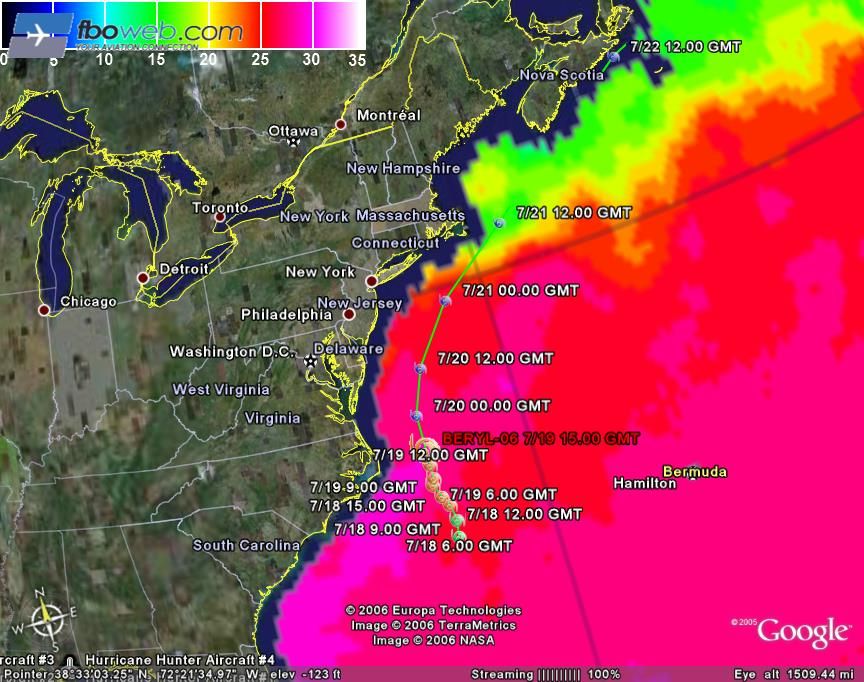
Tropical Storm Beryl
Moderator: S2k Moderators
- cheezyWXguy
- Category 5

- Posts: 6280
- Joined: Mon Feb 13, 2006 12:29 am
- Location: Dallas, TX
Latest coastal MA forecast for small craft (south of Boston)..I think they may be underdone...
COASTAL WATERS FORECAST
NATIONAL WEATHER SERVICE TAUNTON MA
1051 AM EDT WED JUL 19 2006
COASTAL WATERS FROM THE MERRIMACK RIVER MA TO WATCH HILL RI OUT TO
25 NM
ANZ235-237-200215-
/O.CON.KBOX.SW.Y.0036.060720T1400Z-060720T2200Z/
RHODE ISLAND SOUND-BLOCK ISLAND SOUND-
1051 AM EDT WED JUL 19 2006
...SMALL CRAFT ADVISORY FOR HAZARDOUS SEAS REMAINS IN EFFECT FROM
THURSDAY MORNING THROUGH THURSDAY AFTERNOON...
.THIS AFTERNOON...NE WINDS AROUND 10 KT. SEAS 2 TO 3 FT.
.TONIGHT...NE WINDS 5 TO 10 KT. SEAS 2 TO 4 FT. PATCHY FOG AFTER
MIDNIGHT WITH VSBY 1 TO 3 NM.
.THU...E WINDS 10 TO 15 KT. SEAS 3 TO 5 FT. PATCHY FOG IN THE
MORNING WITH VSBY 1 TO 3 NM.
.THU NIGHT...NE WINDS 10 TO 15 KT. SEAS 4 TO 6 FT. A CHANCE OF
SHOWERS AFTER MIDNIGHT.
.FRI...N WINDS 10 TO 15 KT...BECOMING SW IN THE LATE MORNING AND
AFTERNOON. SEAS 3 TO 5 FT...MAINLY IN S SWELLS. A CHANCE OF SHOWERS
AND TSTMS.
.FRI NIGHT...W WINDS 10 TO 15 KT...BECOMING NW 5 TO 10 KT LATE. SEAS
2 TO 4 FT. A CHANCE OF SHOWERS AND TSTMS IN THE EVENING.
.SAT...NE WINDS 5 TO 10 KT. SEAS 2 TO 4 FT. PATCHY FOG. A CHANCE OF
SHOWERS. SHOWERS LIKELY. VSBY 1 TO 3 NM AFTER MIDNIGHT.
.SUN...NE WINDS 5 TO 10 KT. SEAS 2 TO 4 FT. A CHANCE OF SHOWERS.
VSBY 1 TO 3 NM UNTIL LATE AFTERNOON.
WINDS AND SEAS HIGHER IN AND NEAR TSTMS.
0 likes
- abryant.ma
- Tropical Low

- Posts: 46
- Joined: Wed Jul 19, 2006 11:01 am
- Location: Mashpee, Cape Cod, Massachusetts
i don't really think that Beryl is going to reach hurricane status. the waters are only going to get cooler from here on.  however, the possibility is definately there!
 [/img]
 [/img]
Last edited by abryant.ma on Wed Jul 19, 2006 11:23 am, edited 1 time in total.
0 likes
-
HurricaneHunter914
- Category 5

- Posts: 4439
- Age: 32
- Joined: Fri Mar 10, 2006 7:36 pm
- Location: College Station, TX
0 likes
Personal Forecast Disclaimer:
The posts in this forum are NOT official forecast and should not be used as such. They are just the opinion of the poster and may or may not be backed by sound meteorological data. They are NOT endorsed by any professional institution or storm2k.org. For official information, please refer to the NHC and NWS products.
The posts in this forum are NOT official forecast and should not be used as such. They are just the opinion of the poster and may or may not be backed by sound meteorological data. They are NOT endorsed by any professional institution or storm2k.org. For official information, please refer to the NHC and NWS products.
-
HurricaneHunter914
- Category 5

- Posts: 4439
- Age: 32
- Joined: Fri Mar 10, 2006 7:36 pm
- Location: College Station, TX
If Beryl moved slightly to the west, she would have had a better chance of becoming a hurricane.
0 likes
Personal Forecast Disclaimer:
The posts in this forum are NOT official forecast and should not be used as such. They are just the opinion of the poster and may or may not be backed by sound meteorological data. They are NOT endorsed by any professional institution or storm2k.org. For official information, please refer to the NHC and NWS products.
The posts in this forum are NOT official forecast and should not be used as such. They are just the opinion of the poster and may or may not be backed by sound meteorological data. They are NOT endorsed by any professional institution or storm2k.org. For official information, please refer to the NHC and NWS products.
-
Matt-hurricanewatcher
-
Matt-hurricanewatcher
- cheezyWXguy
- Category 5

- Posts: 6280
- Joined: Mon Feb 13, 2006 12:29 am
- Location: Dallas, TX
- Extremeweatherguy
- Category 5

- Posts: 11095
- Joined: Mon Oct 10, 2005 8:13 pm
- Location: Florida
-
Matt-hurricanewatcher
- cheezyWXguy
- Category 5

- Posts: 6280
- Joined: Mon Feb 13, 2006 12:29 am
- Location: Dallas, TX
- Extremeweatherguy
- Category 5

- Posts: 11095
- Joined: Mon Oct 10, 2005 8:13 pm
- Location: Florida
Who is online
Users browsing this forum: No registered users and 7 guests


