MJO
Moderator: S2k Moderators
Forum rules
The posts in this forum are NOT official forecasts and should not be used as such. They are just the opinion of the poster and may or may not be backed by sound meteorological data. They are NOT endorsed by any professional institution or STORM2K. For official information, please refer to products from the National Hurricane Center and National Weather Service.
Not really sure why the comment should be deleted. It is an opinion just as most of what is posted is. There is no statement made to the effect that the MJO has not been proven to have any effect, just that in the opinion of the poster, this current edition will have little impact on the Atlantic basin, as have the last several. Delete the post ??????? Why not burn books as well.
0 likes
- 'CaneFreak
- Category 5

- Posts: 1487
- Joined: Mon Jun 05, 2006 10:50 am
- Location: New Bern, NC
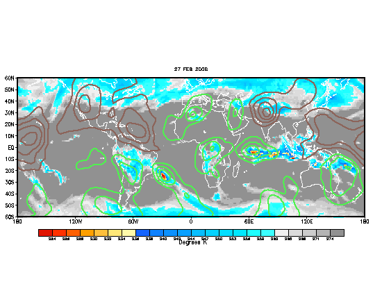
looky looky...the subsidence is gone in the atlantic...could this be a sign of things to come? We'll see.....
http://www.cpc.ncep.noaa.gov/products/p ... thly.shtml
http://www.cpc.ncep.noaa.gov/products/p ... thly.shtml
0 likes
- SouthFloridawx
- S2K Supporter

- Posts: 8346
- Age: 47
- Joined: Tue Jul 26, 2005 1:16 am
- Location: Sarasota, FL
- Contact:
'CaneFreak wrote:looky looky...the subsidence is gone in the atlantic...could this be a sign of things to come? We'll see.....
http://www.cpc.ncep.noaa.gov/products/p ... thly.shtml
Looks like your 100% right.
0 likes
- cycloneye
- Admin

- Posts: 148755
- Age: 69
- Joined: Thu Oct 10, 2002 10:54 am
- Location: San Juan, Puerto Rico

The wet phase of MJO is already in parts of the Atlantic.However the full wet phase is still in the Pacific.
0 likes
Visit the Caribbean-Central America Weather Thread where you can find at first post web cams,radars
and observations from Caribbean basin members Click Here
and observations from Caribbean basin members Click Here
- cycloneye
- Admin

- Posts: 148755
- Age: 69
- Joined: Thu Oct 10, 2002 10:54 am
- Location: San Juan, Puerto Rico
The wet phase is spreading thru the Eastern Atlantic where TD #4 is and where the central Atlantic Wave is.
0 likes
Visit the Caribbean-Central America Weather Thread where you can find at first post web cams,radars
and observations from Caribbean basin members Click Here
and observations from Caribbean basin members Click Here
- 'CaneFreak
- Category 5

- Posts: 1487
- Joined: Mon Jun 05, 2006 10:50 am
- Location: New Bern, NC
- 'CaneFreak
- Category 5

- Posts: 1487
- Joined: Mon Jun 05, 2006 10:50 am
- Location: New Bern, NC
- LAwxrgal
- S2K Supporter

- Posts: 1763
- Joined: Tue Jul 06, 2004 1:05 pm
- Location: Reserve, LA (30 mi west of NOLA)
The wet phase of the MJO and the increase in activity....Nope, don't think this is merely a coincidence either.
0 likes
Andrew 92/Isidore & Lili 02/Bill 03/Katrina & Rita 05/Gustav & Ike 08/Isaac 12 (flooded my house)/Harvey 17/Barry 19/Cristobal 20/Claudette 21/Ida 21 (In the Eye)/Francine 24
Wake me up when November ends
Wake me up when November ends
- cycloneye
- Admin

- Posts: 148755
- Age: 69
- Joined: Thu Oct 10, 2002 10:54 am
- Location: San Juan, Puerto Rico

The wet pulse of MJO is strong now in the Atlantic.
0 likes
Visit the Caribbean-Central America Weather Thread where you can find at first post web cams,radars
and observations from Caribbean basin members Click Here
and observations from Caribbean basin members Click Here
-
willjnewton
-
whereverwx
- Category 5

- Posts: 1109
- Joined: Mon May 31, 2004 10:15 pm
- wxmann_91
- Category 5

- Posts: 8013
- Age: 34
- Joined: Fri Jul 15, 2005 2:49 pm
- Location: Southern California
- Contact:
There has been a noticable lack of convection besides Ioke in the CPAC. So, yes, the dry MJO has had an effect. The entire CPAC is now very hostile due to a strong TUTT that has formed north of Hawaii.
I think the MJO may have to do more with the formation of storms rather than the intensification of storms.
I think the MJO may have to do more with the formation of storms rather than the intensification of storms.
0 likes
-
Thatsmrhurricane
- Tropical Storm

- Posts: 182
- Joined: Fri Jun 09, 2006 5:30 pm
- Location: CBNC
- Portastorm
- Storm2k Moderator

- Posts: 9915
- Age: 63
- Joined: Fri Jul 11, 2003 9:16 am
- Location: Round Rock, TX
- Contact:
According to a published article in SCIENCE, hurricane genesis is four times more likely in the WCarib and GOM when MJO winds are westerly.
Link: http://www.sciencemag.org/cgi/content/a ... /5460/2002
Link: http://www.sciencemag.org/cgi/content/a ... /5460/2002
0 likes
Who is online
Users browsing this forum: Ulf and 34 guests

