TD Ernesto Satellite,Analysis and Models Thread #8
Moderator: S2k Moderators
Forum rules

The posts in this forum are NOT official forecasts and should not be used as such. They are just the opinion of the poster and may or may not be backed by sound meteorological data. They are NOT endorsed by any professional institution or STORM2K. For official information, please refer to products from the National Hurricane Center and National Weather Service.

-
skysummit

- S2K Supporter

- Posts: 5305
- Age: 50
- Joined: Tue Aug 31, 2004 11:09 pm
- Location: Ponchatoula, LA
- Contact:
Brent wrote:tallywx wrote:Man, what winds you all are getting in the Miami metro...
E15 at MIA
E13 at Fort Lauderdale
NE 12 at Homestead
E15 at Opa Locka
How can you all manage that? Seriously, don't you normally get stronger winds after the seabreeze front passes through every afternoon?
Seriously.

LOL...I'm not even sure if a kite can stay up with those winds!
0 likes
-
Evil Jeremy

- S2K Supporter
- Posts: 5463
- Age: 32
- Joined: Mon Apr 10, 2006 2:10 pm
- Location: Los Angeles, CA
http://radar.weather.gov/ridge/radar.ph ... 1&loop=yes
look at that huge rainband off of the East Coast, its going to bring in aloooooooot of rain here!
look at that huge rainband off of the East Coast, its going to bring in aloooooooot of rain here!
0 likes
Frances 04 / Jeanne 04 / Katrina 05 / Wilma 05 / Fay 08 / Debby 12 / Andrea 13 / Colin 16 / Hermine 16 / Matthew 16 / Irma 17
-
Dean4Storms
- S2K Supporter
- Posts: 6358
- Age: 62
- Joined: Sun Aug 31, 2003 1:01 pm
- Location: Miramar Bch. FL
-
wsoutherland

- Tropical Low

- Posts: 20
- Joined: Sat Jun 10, 2006 4:14 pm
- Location: Bradenton, FL
- Contact:
Re: A question... maybe simple
Brent wrote:wsoutherland wrote:So...even though there is a near consensus on an eventual turn eastward
as Ernesto works his way up Florida, could someone (maybe someone who
understands NHC reasoning more than I do) please explain to me why
Sarasota County, Manatee County and Tampa Bay is still only under a
TS Watch, even at the 8pm advisory?
--snip --
Well a TS watch is for TS force winds. Since they are not likely to occur, that's why. They aren't for heavy rain.
Duh...sorry...you'd think I could have thought of that myself. Nonetheless,
and this will be my last rant, I just can't imagine there is enough
certainty about the eastward track to not play it at least a *little* bit more
cautiously on the West Coast. Well...I guess another Wednesday at
work won't kill me! (Sob.) At least I can count on only a small fraction
of my students actually showing up, I suppose. I worry about them, too,
though -- they are largely newbie drivers after all, hardly ready for bad
conditions even at this level. Thanks for the answer.
0 likes
-
Stormavoider
- Category 2

- Posts: 671
- Joined: Sat Jul 01, 2006 4:37 pm
- Location: Spring Hill Fl.
For a while there it looked like two centers. Then it opened up into one big one moving NW.dcuevas wrote:Stormavoider - I was looking at the animation from 8pm today. 24.8N 80.4W NW movement at 12mph - 1004 mb. Maybe something is wrong with my eyes. Let me find an updated one. I know I saw something
Here's an interesting IR view.
http://wwwghcc.msfc.nasa.gov/cgi-bin/get-goes?satellite=GOES-E%20CONUS&lat=25&lon=-81&info=ir&zoom=1&width=2800&height=2000&type=Animation&numframes=8&palette=spect.pal
0 likes
-
TreasureIslandFLGal

- S2K Supporter
- Posts: 1584
- Age: 58
- Joined: Sun Aug 15, 2004 6:16 pm
- Location: Cancun, Mexico (northeast Yucatan coast)
that is a great radar and the two of us here looking at it, we both agree that the center appears to be making landfall just to the northeast of Marathon on the keys and moving in a WNW direction. If it keeps up that motion, it will be staying over the water for quite a while longer.
Maybe our 4 combined eyes are playing tricks on us, but that is our OPINION.
Maybe our 4 combined eyes are playing tricks on us, but that is our OPINION.
0 likes
-
Evil Jeremy
- S2K Supporter
- Posts: 5463
- Age: 32
- Joined: Mon Apr 10, 2006 2:10 pm
- Location: Los Angeles, CA
-
HURAKAN

- Professional-Met

- Posts: 46086
- Age: 38
- Joined: Thu May 20, 2004 4:34 pm
- Location: Key West, FL
- Contact:

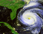
Hey, there's is a big thunderstorm complex affecting South Florida and the northern Bahamas. Oh, sorry, is Ernesto!!!
From a general image of thr Atlantic Ernesto seems to be almost nothing. The thunderstorm between Panama and Colombia and the wave in the far Atlantic looks more impressive. But Ernesto has something the other lack, a center of circulation!!!
0 likes
-
Evil Jeremy
- S2K Supporter
- Posts: 5463
- Age: 32
- Joined: Mon Apr 10, 2006 2:10 pm
- Location: Los Angeles, CA
VOrtex Message wrote:161
URNT12 KNHC 300154
VORTEX DATA MESSAGE
A. 30/01:24:20Z
B. 24 deg 52 min N
080 deg 28 min W
C. 850 mb 1455 m
D. NA kt
E. NA deg nm
F. 117 deg 040 kt
G. 040 deg 098 nm
H. 1004 mb
I. 17 C/ 1525 m
J. 18 C/ 1523 m
K. 16 C/ NA
L. NA
M. NA
N. 134 / 8
O. 0.02 / 6 nm
P. AF300 1805A ERNESTO OB 10
MAX FL WIND 46 KT SE QUAD 23:40:50 Z
FL CTR ELONGATED NE TO SW
;
0 likes
Frances 04 / Jeanne 04 / Katrina 05 / Wilma 05 / Fay 08 / Debby 12 / Andrea 13 / Colin 16 / Hermine 16 / Matthew 16 / Irma 17
Who is online
Users browsing this forum: JoshwaDone, WaveBreaking and 82 guests