Models Showing System Off African Coast 96 Hours
Moderator: S2k Moderators
Forum rules

The posts in this forum are NOT official forecasts and should not be used as such. They are just the opinion of the poster and may or may not be backed by sound meteorological data. They are NOT endorsed by any professional institution or STORM2K. For official information, please refer to products from the National Hurricane Center and National Weather Service.

-
SouthFloridawx

- S2K Supporter

- Posts: 8346
- Age: 47
- Joined: Tue Jul 26, 2005 1:16 am
- Location: Sarasota, FL
- Contact:
CMC 12Z
http://moe.met.fsu.edu/cgi-bin/cmctc2.c ... hour=144hr
GFS 12Z
http://moe.met.fsu.edu/cgi-bin/gfstc2.c ... hour=144hr
UKMET 12Z
http://moe.met.fsu.edu/cgi-bin/ukmtc2.c ... hour=144hr
Still waiting on the Nogaps and MM5FSU.
http://moe.met.fsu.edu/cgi-bin/cmctc2.c ... hour=144hr
GFS 12Z
http://moe.met.fsu.edu/cgi-bin/gfstc2.c ... hour=144hr
UKMET 12Z
http://moe.met.fsu.edu/cgi-bin/ukmtc2.c ... hour=144hr
Still waiting on the Nogaps and MM5FSU.
0 likes

-
Derek Ortt


-
SouthFloridawx
- S2K Supporter
- Posts: 8346
- Age: 47
- Joined: Tue Jul 26, 2005 1:16 am
- Location: Sarasota, FL
- Contact:

-
SouthFloridawx
- S2K Supporter
- Posts: 8346
- Age: 47
- Joined: Tue Jul 26, 2005 1:16 am
- Location: Sarasota, FL
- Contact:
http://www.ssd.noaa.gov/PS/TROP/trop-atl.html
 I really like this site that has all of the views of the Atlantic that you could want plus the floaters.
Also Probablilites are looking good for development.

Also cyclone formation is way up.
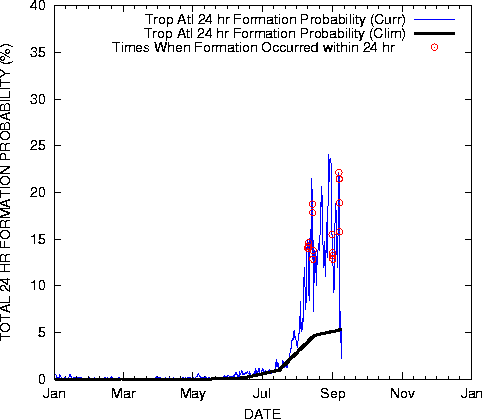
Windshear is also fairly low.
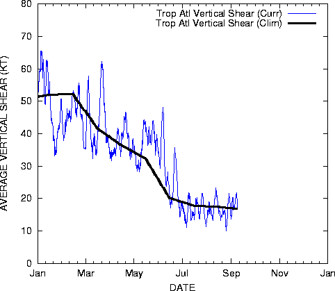
Also Probablilites are looking good for development.

Also cyclone formation is way up.
Windshear is also fairly low.
0 likes
-
Aquawind

- Category 5

- Posts: 6714
- Age: 62
- Joined: Mon Jun 16, 2003 10:41 pm
- Location: Salisbury, NC
- Contact:
Starting to look like September. We will have some invests very soon.
http://www.ssd.noaa.gov/PS/TROP/DATA/RT/EATL/IR4/20.jpg
http://www.ssd.noaa.gov/PS/TROP/DATA/RT/EATL/IR4/20.jpg
0 likes
-
SouthFloridawx
- S2K Supporter
- Posts: 8346
- Age: 47
- Joined: Tue Jul 26, 2005 1:16 am
- Location: Sarasota, FL
- Contact:
http://www.nco.ncep.noaa.gov/pmb/nwprod ... v_054m.gif
GFS 00Z still showing development off the coast of Africa.
We could be very busy in the next couple of weeks tracking some storms.
GFS 00Z still showing development off the coast of Africa.
We could be very busy in the next couple of weeks tracking some storms.
0 likes
-
SouthFloridawx
- S2K Supporter
- Posts: 8346
- Age: 47
- Joined: Tue Jul 26, 2005 1:16 am
- Location: Sarasota, FL
- Contact:
http://www.nco.ncep.noaa.gov/pmb/nwprod ... v_078m.gif
GFS showing a 1004mb low pressure in the E. Atlantic. I think we'll be seeing some development in the next week.
http://www.nco.ncep.noaa.gov/pmb/nwprod ... p_078m.gif
GFS showing a 1004mb low pressure in the E. Atlantic. I think we'll be seeing some development in the next week.
http://www.nco.ncep.noaa.gov/pmb/nwprod ... p_078m.gif
0 likes
-
SouthFloridawx
- S2K Supporter
- Posts: 8346
- Age: 47
- Joined: Tue Jul 26, 2005 1:16 am
- Location: Sarasota, FL
- Contact:
-
HenkL
- S2K Supporter
- Posts: 2401
- Joined: Fri Sep 10, 2004 5:33 pm
- Location: Groningen, The Netherlands
- Contact:
Forecast issued for the NAMMA project:
"NAMMA weather forecast Sept 2 2006
September 2nd, 2006
NAMMA forecast Sept 2
Today is a no-fly day. The convection embedded in the ITCZ is not expected to intensify until Sept 3. Heavy dust loading can be seen as far as 53W. The southern edge of the dust plume is south of CV near 15W. The dust plume we sampled yesterday is steadily moving west and reached 22W. A small-amplitude AEW is located southeast of the CV embedded in the ITCZ and moderate convection is occurring. Convection associated with the wave is near 14N17W. Due to dry and dusty air ahead, this convection is expected to weaken in the next 12 hours. Another strong convection behind the wave is located near 10N10W. Strong monsoon trough bringing moisture from the southwest may support and strengthen this convection for the next 24 hours. The wave amplitude will increase and gradually form a closed circulation by 06Z Sept 3 centered at 12N20W. Both GFS and UIUC-WRF shows the circulation is well organized and shows sign of intensification for the next 24 hours. By 12Z Sept 3, the center is at 14N22W by GFS and 18N18W by UIUC-WRF. The GFS is taking the wave to the northwest over the island through Monday. General model consensus (GFS, UIUC-WRF, ECMWF, and ARPEGE) is to develop the wave west of the island towards a tropical depression intensity through Sept 3 to 4. Tomorrow is a scheduled fly day."
Daily forecasts for the project can be found here.
0 likes
-
SouthFloridawx
- S2K Supporter
- Posts: 8346
- Age: 47
- Joined: Tue Jul 26, 2005 1:16 am
- Location: Sarasota, FL
- Contact:
-
HurricaneHunter914
- Category 5
- Posts: 4439
- Age: 32
- Joined: Fri Mar 10, 2006 7:36 pm
- Location: College Station, TX
http://www.ssd.noaa.gov/PS/TROP/DATA/RT/EATL/IR4/20.jpg
This wave behind 98L appears to have some cyclonic turning and the wave behind it doesn't look bad either.
This wave behind 98L appears to have some cyclonic turning and the wave behind it doesn't look bad either.
0 likes
Personal Forecast Disclaimer:
The posts in this forum are NOT official forecast and should not be used as such. They are just the opinion of the poster and may or may not be backed by sound meteorological data. They are NOT endorsed by any professional institution or storm2k.org. For official information, please refer to the NHC and NWS products.
The posts in this forum are NOT official forecast and should not be used as such. They are just the opinion of the poster and may or may not be backed by sound meteorological data. They are NOT endorsed by any professional institution or storm2k.org. For official information, please refer to the NHC and NWS products.
-
wxman57

- Moderator-Pro Met

- Posts: 23131
- Age: 68
- Joined: Sat Jun 21, 2003 8:06 pm
- Location: Houston, TX (southwest)
Derek Ortt wrote:watch the system near 20W. It may be the one that goes. The one the models are developing may be like Debby was to Ernesto and block the SAL
I agree, it's near 23N now. I thought THAT was 99L, as it looks like the most impressive disturbance out there. Interesting, the Atlantic TWO just came out and there's no mention of the system in the eastern Atlantic.
0 likes
Who is online
Users browsing this forum: No registered users and 64 guests