

First Advisory
Thread One
Florence on Monday? Or even tonight?
T.D. Six - Sat Pics, Comments,Models Thread #2
Moderator: S2k Moderators
Forum rules

The posts in this forum are NOT official forecasts and should not be used as such. They are just the opinion of the poster and may or may not be backed by sound meteorological data. They are NOT endorsed by any professional institution or STORM2K. For official information, please refer to products from the National Hurricane Center and National Weather Service.
-
Derek Ortt
-
JonathanBelles
- Professional-Met

- Posts: 11430
- Age: 35
- Joined: Sat Dec 24, 2005 9:00 pm
- Location: School: Florida State University (Tallahassee, FL) Home: St. Petersburg, Florida
- Contact:

-
Grease Monkey

- Category 2

- Posts: 727
- Joined: Fri Jun 09, 2006 9:25 pm
-
WindRunner

- Category 5

- Posts: 5806
- Age: 35
- Joined: Fri Jul 29, 2005 8:07 pm
- Location: Warrenton, VA, but Albany, NY for school
- Contact:
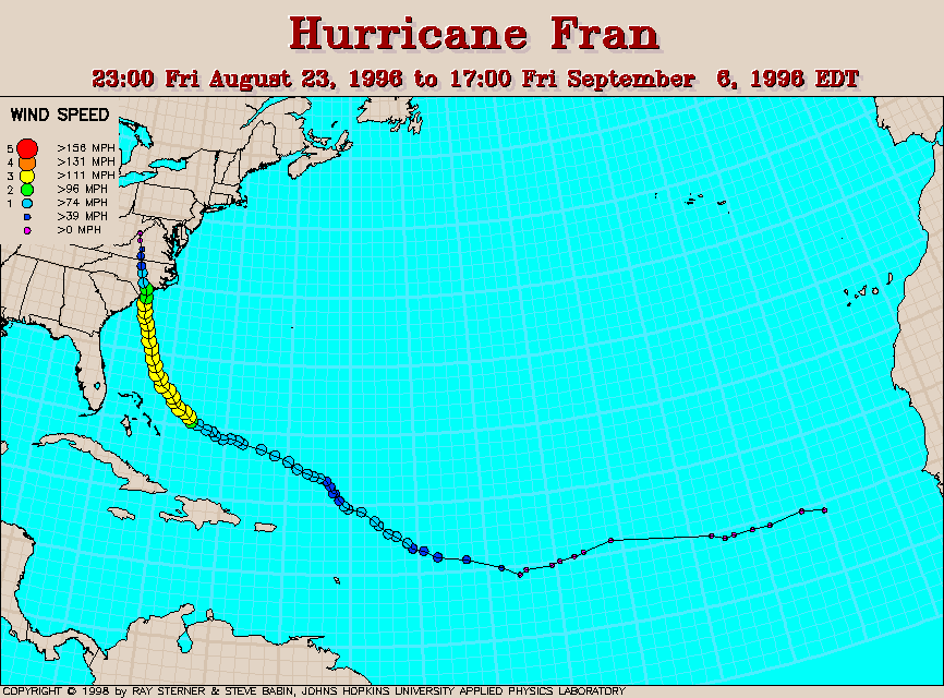
Trugunzn wrote:could be track like this:
-clipped image of Fran track from http://www.atmos.umd.edu/~stevenb/hurr/96/fran/fran_v2.gif-
Yeah, that seems very possible right now.
EDIT for link
Last edited by WindRunner on Sun Sep 03, 2006 4:02 pm, edited 1 time in total.
0 likes
-
WindRunner
- Category 5
- Posts: 5806
- Age: 35
- Joined: Fri Jul 29, 2005 8:07 pm
- Location: Warrenton, VA, but Albany, NY for school
- Contact:
-
Weatherfreak14

- Category 5
- Posts: 1383
- Joined: Sat Sep 24, 2005 3:40 pm
- Location: Beaufort, SC
- Contact:


-
SouthFloridawx

- S2K Supporter

- Posts: 8346
- Age: 47
- Joined: Tue Jul 26, 2005 1:16 am
- Location: Sarasota, FL
- Contact:
I would not be entirely suprised if the ULT picks this thing up. It is fairly evident on sat. imagery that the trough is affecting this system already.
http://hadar.cira.colostate.edu/ramsdis/on...ge_wv_ls_0.html
The trough was darting southward very quckly but, looks to be slowing up now.
There is one key factor for TD6 in the near term. If the trough sticks around longer, #6 is going out to sea a lot faster than forecasted.
If the trough pulls out quickly it's time for the east coast to start checking thier supplies. GFS is forecasting a fairly decent 500mb ridge throughout the next week.
0 likes
-
wxmann_91

- Category 5
- Posts: 8013
- Age: 34
- Joined: Fri Jul 15, 2005 2:49 pm
- Location: Southern California
- Contact:
Very important - If the center reforms to the north, both the track and intensity forecasted will have be adjusted dramatically. When I mean that, I mean that a) Florence will be Fish and b) Florence isn't going to strengthen beyond TS status. It threw off Irene in 2005, and Ernesto this year.
0 likes
-
Stratosphere747
- Category 5
- Posts: 3772
- Joined: Thu Sep 11, 2003 8:34 pm
- Location: Surfside Beach/Freeport Tx
- Contact:
-
johngaltfla

- Category 5
- Posts: 2073
- Joined: Sun Jul 10, 2005 9:17 pm
- Location: Sarasota County, FL
- Contact:
Interesting analysis SouthFloridawx. I'm not as concerned about this storm being a Florida threat as much of an East Coast threat. That's when things on this board will get interesting. I hope it's a fish, but if you're right and it does miss and the ridge builds in, it has time to develop and keep on chugging westward.
0 likes
-
huricanwatcher

- Category 3

- Posts: 893
- Age: 65
- Joined: Sat Sep 13, 2003 6:09 pm
- Location: Kirkwood NY
- Contact:
-
SouthFloridawx
- S2K Supporter
- Posts: 8346
- Age: 47
- Joined: Tue Jul 26, 2005 1:16 am
- Location: Sarasota, FL
- Contact:

-
cycloneye

- Admin

- Posts: 148755
- Age: 69
- Joined: Thu Oct 10, 2002 10:54 am
- Location: San Juan, Puerto Rico
SouthFloridawx,what do you mean by another tricky one?
0 likes
Visit the Caribbean-Central America Weather Thread where you can find at first post web cams,radars
and observations from Caribbean basin members Click Here
and observations from Caribbean basin members Click Here
-
Derek Ortt
-
SouthAlabamaWX

- Tropical Low

- Posts: 47
- Joined: Fri Aug 11, 2006 1:01 am
- Location: Coastal Alabama
The GFS didn't initialize the system (TD#6) well today. Note, that the GFS is not mentioned in the TCD this evening by Franklin. He decided not to use it. It is too early to read into any models at this point. Just last week the models had Estesto moving to Texas and the GOM. The models will change many times over the next several days. It is too early to know for sure where TD#6 will go.
0 likes
-
SouthFloridawx
- S2K Supporter
- Posts: 8346
- Age: 47
- Joined: Tue Jul 26, 2005 1:16 am
- Location: Sarasota, FL
- Contact:
cycloneye wrote:SouthFloridawx,what do you mean by another tricky one?
I mean there is no clear cut answer to the track. I know there are always variables into the track a storm takes but, this one is highly dependant on the through to it's north and a subsequent ridge building on top of it. I was reading at another forum and they noted that the ECM breaks down the ridge and has an opposite forecast of the GFS. Here is the image that was posted at another forum.. (giving them credit easternwx)

0 likes
Who is online
Users browsing this forum: No registered users and 84 guests