I agree. at this point I would just be happy to see some flakes in the air.Johnny wrote:15 minutes worth of flurries is good enough for me! lol
Texas Winter Weather Thread #3 - GFS showing cold christmas
Moderator: S2k Moderators
Forum rules
 The posts in this forum are NOT official forecast and should not be used as such. They are just the opinion of the poster and may or may not be backed by sound meteorological data. They are NOT endorsed by any professional institution or STORM2K.

The posts in this forum are NOT official forecast and should not be used as such. They are just the opinion of the poster and may or may not be backed by sound meteorological data. They are NOT endorsed by any professional institution or STORM2K.
-
Extremeweatherguy

- Category 5

- Posts: 11095
- Joined: Mon Oct 10, 2005 8:13 pm
- Location: Florida
-
Extremeweatherguy
- Category 5
- Posts: 11095
- Joined: Mon Oct 10, 2005 8:13 pm
- Location: Florida
Take a look at the radar! I see no way that Houston can miss this sheild of precip...
http://wwwa.accuweather.com/radar-large ... te&large=1
Seems to have an aim toward the ENE or NE...right toward us.
http://wwwa.accuweather.com/radar-large ... te&large=1
Seems to have an aim toward the ENE or NE...right toward us.
0 likes
-
PTrackerLA

- Category 5
- Posts: 5281
- Age: 42
- Joined: Thu Oct 10, 2002 8:40 pm
- Location: Lafayette, LA
Here's a good shot of it coming out of San Antonio.
http://www.mysanantonio.com/multimedia/ ... ler_lg.gif
http://www.mysanantonio.com/multimedia/ ... ler_lg.gif
0 likes
-
jasons2k

- Storm2k Executive

- Posts: 8290
- Age: 52
- Joined: Wed Jul 06, 2005 12:32 pm
- Location: The Woodlands, TX
Extremeweatherguy wrote:Take a look at the radar! I see no way that Houston can miss this sheild of precip...
http://wwwa.accuweather.com/radar-large ... te&large=1
Seems to have an aim toward the ENE or NE...right toward us.
There is a way and it's called incredibly dry air.
Yes, it's moving in the right direction, but look at the radar out of San Antonio - hi-res if possible - and watch what happens to the intensity & coverage of the shield as it moves ENE.
Believe me - I'd LOVE for it to make it this time - I just don't see it - yet
0 likes
-
Extremeweatherguy
- Category 5
- Posts: 11095
- Joined: Mon Oct 10, 2005 8:13 pm
- Location: Florida
If it moves over us, then the precipitation (as virga) will likely be enough to moisten up our air a bit. If that can occur, I think it is very possible we see something out of this.jschlitz wrote:Extremeweatherguy wrote:Take a look at the radar! I see no way that Houston can miss this sheild of precip...
http://wwwa.accuweather.com/radar-large ... te&large=1
Seems to have an aim toward the ENE or NE...right toward us.
There is a way and it's called incredibly dry air.
Yes, it's moving in the right direction, but look at the radar out of San Antonio - hi-res if possible - and watch what happens to the intensity & coverage of the shield as it moved ENE.
Believe me - I'd LOVE for it to make it this time - I just don't see it - yet
Also, it does look like the heavy precip. cores are holding their own as they move NE this afternoon (based on Johnny's radar link):
http://www.mysanantonio.com/multimedia/ ... ler_lg.gif
At this moment I am just trying to have hope it reaches us and brings us a nice surprise!
Last edited by Extremeweatherguy on Fri Dec 08, 2006 4:01 pm, edited 1 time in total.
0 likes
-
Yankeegirl

- Category 5
- Posts: 3417
- Age: 50
- Joined: Sun May 23, 2004 11:59 pm
- Location: Cy-Fair, Northwest Houston
- Contact:
-
Yankeegirl
- Category 5
- Posts: 3417
- Age: 50
- Joined: Sun May 23, 2004 11:59 pm
- Location: Cy-Fair, Northwest Houston
- Contact:
-
Extremeweatherguy
- Category 5
- Posts: 11095
- Joined: Mon Oct 10, 2005 8:13 pm
- Location: Florida
pretty cool image from weather.com this afternoon:
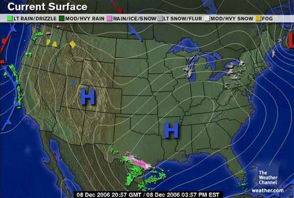
It's not often that you see something like this!
It's not often that you see something like this!
Last edited by Extremeweatherguy on Fri Dec 08, 2006 4:06 pm, edited 1 time in total.
0 likes
-
weatherrabbit_tx

- Category 1

- Posts: 270
- Joined: Wed Dec 21, 2005 3:13 pm
- Location: Kingwood,Tx
- Contact:
-
Yankeegirl
- Category 5
- Posts: 3417
- Age: 50
- Joined: Sun May 23, 2004 11:59 pm
- Location: Cy-Fair, Northwest Houston
- Contact:

-
weatherrabbit_tx
- Category 1
- Posts: 270
- Joined: Wed Dec 21, 2005 3:13 pm
- Location: Kingwood,Tx
- Contact:
Yankeegirl wrote:Let me get out my web cam and ill do it again, not!! lol.....
haha!
Last edited by weatherrabbit_tx on Fri Dec 08, 2006 4:11 pm, edited 1 time in total.
0 likes

-
jasons2k
- Storm2k Executive
- Posts: 8290
- Age: 52
- Joined: Wed Jul 06, 2005 12:32 pm
- Location: The Woodlands, TX
Extremeweatherguy wrote:
Also, it does look like the heavy precip. cores are holding their own as they move NE this afternoon (based on Johnny's radar link):
http://www.mysanantonio.com/multimedia/ ... ler_lg.gif
At this moment I am just trying to have hope it reaches us and brings us a nice surprise!
Saw the link. Look at a Level 2 or Level 3 radar - that tells the story - the dry air is eating it away - like I said - it would take a LOT of intense Virga to moisten the column all the way to the surface. Plus the low itself is opening up, not closing off.
Not that it absolutely can't happen, but I wouldn't stay up waiting for anything this time around.
0 likes
-
Extremeweatherguy
- Category 5
- Posts: 11095
- Joined: Mon Oct 10, 2005 8:13 pm
- Location: Florida
http://www.weather.com/weather/map/7737 ... ated&day=1
Well, regardless of what happens, the above link is still fun to look at. Let's just hope SOMETHING (even a single flurry) can result from this. Though it is unlikely, I will still have hope until the threat is completely over with.
Well, regardless of what happens, the above link is still fun to look at. Let's just hope SOMETHING (even a single flurry) can result from this. Though it is unlikely, I will still have hope until the threat is completely over with.
0 likes
-
Yankeegirl
- Category 5
- Posts: 3417
- Age: 50
- Joined: Sun May 23, 2004 11:59 pm
- Location: Cy-Fair, Northwest Houston
- Contact:
Still the temps here are holding pretty good, its 48 here right now, and the sun is back out... I also have little hope for any type of wintery mix, but it was fun to look at .... unless the temp nosedives and the moisture flows in at the same time, I think the snow this time is a no go.... Winter just started, we have a few more months to get all hyped up again... and I think there is a definate chance that we are going to see something this winter... just not tonight... or tomorrow...
0 likes
-
Portastorm

- Storm2k Moderator

- Posts: 9954
- Age: 63
- Joined: Fri Jul 11, 2003 9:16 am
- Location: Round Rock, TX
- Contact:
cctxhurricanewatcher wrote:Wow, this looks awfully familar to a certain snow event in 2004.Low 40's during the day like it is right now, with freezing precip of some sort falling to the north and west of Corpus. I rememeber sitting on my computer looking at the radars at this time during the day and seeing the precip in the same areas and monitoring the temps.
And then, wham at night the snow fell. I doubt this event will be similar, but no one in their right minds back then expected that event also.
So I say to my bud Portastorm in Austin. I'll see you a snow ball via FedEx.
Gggrrrrr ....
Once again I get cloudy and cold. CC ... you dirty dawg!
0 likes
-
Extremeweatherguy
- Category 5
- Posts: 11095
- Joined: Mon Oct 10, 2005 8:13 pm
- Location: Florida
check out the forecast for VICTORIA (whithin the corpus christi NWS area):
And then take a look at the zone forecast a few miles away (from the Houston NWS area):
Something doesn't quite add up here. I don't see how it would snow/sleet in Vicotoria (50% chance), and then a few miles away there is just a 20% chance of only rain. Seems like the two NWS offices do not agree on the situation in the same way right now.
This Afternoon: A chance of rain, snow and sleet. Cloudy, with a steady temperature around 43. North wind between 3 and 5 mph. Chance of precipitation is 50%.
Tonight: A chance of rain, snow and sleet. Cloudy, with a low around 34. North northeast wind between 3 and 7 mph. Chance of precipitation is 50%.
Saturday: A chance of rain, snow and sleet before 9am, then a chance of rain. Cloudy, with a high near 50. East northeast wind between 5 and 8 mph. Chance of precipitation is 50%.
And then take a look at the zone forecast a few miles away (from the Houston NWS area):
This Afternoon: Mostly cloudy, with a high near 51. South wind around 5 mph becoming calm.
Tonight: A 20 percent chance of rain. Mostly cloudy, with a low around 36. Northeast wind around 5 mph.
Saturday: A 30 percent chance of rain. Mostly cloudy, with a high near 60. East wind between 5 and 10 mph.
Something doesn't quite add up here. I don't see how it would snow/sleet in Vicotoria (50% chance), and then a few miles away there is just a 20% chance of only rain. Seems like the two NWS offices do not agree on the situation in the same way right now.
0 likes
Who is online
Users browsing this forum: No registered users and 131 guests