 The posts in this forum are NOT official forecast and should not be used as such. They are just the opinion of the poster and may or may not be backed by sound meteorological data. They are NOT endorsed by any professional institution or

Two points are in order:
- The Northern Hemisphere has continued to warm in recent years (cold anomalies tending to be less expansive and less severe, on average).
- December 2006 saw only a small portion of the Northern Hemisphere average below normal, which is in stark contrast to past seasons in which long-duration, much below normal readings covered a large part of the CONUS.
These two points will likely argue for some modification from historic figures. However, the area of cold anomalies has been improving and this development may enhance prospects for a colder than normal February if the pattern cooperates. Nevertheless, I still don't expect a large part of the CONUS to be severely cold for the month as a whole along the lines of February 1978.
Northern Hemisphere Anomalies (using 2° increments) for December 1-31, 2006:

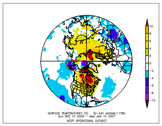
Northern Hemisphere Anomalies (using 2° increments) for December 10, 2006-January 10, 2007:
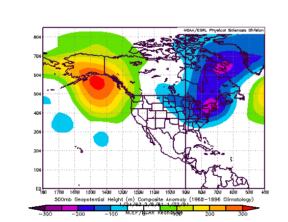
The NCEP Ensemble 500 mb anomalies forecast for 240 hours reasonably resemble those seen on January 24, 1963, February 5, 1981, and January 22, 1991, particularly with respect to North America.
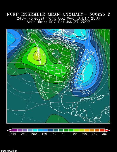
NCEP 500 mb Anomalies (240 hours): North America:
Composite Analog 500 mb Anomalies: North America:
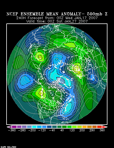
Reasonable similarity also exists across the Northern Hemisphere.
NCEP 500 mb Anomalies (240 hours): Northern Hemisphere:
Composite Analog 500 mb Anomalies: Northern Hemisphere:

The NCEP Ensemble forecast for 240 hours shows a sizable area of cold air:

Lowest temperature during the past cold outbreaks referenced above for select cities:
January 21-29, 1963:
Atlanta: -3°
Boston: 4°
Burlington: -17°
Detroit: -13°
New York City: 4°
Philadelphia: -2°
Richmond: 9°
Washington, DC (DCA): 3°
February 3-6, 1981:
Atlanta: 15°
Boston: 13°
Burlington: 3°
Detroit: 1°
New York City: 8°
Philadelphia: 9°
Richmond: 12°
Washington, DC (DCA): 18°
January 21-26, 1991:
Atlanta: 20°
Boston: 4°
Burlington: -9°
Detroit: 2°
New York City: 10°
Philadelphia: 13°
Richmond: 16°
Washington, DC (DCA): 18°
Given the earlier caveats, I do not expect an air mass that rivals that of January 1963. The latter two are probably more representative of the peak magnitude of cold that one might see during the January 23-31 timeframe.
Therefore, based on a combination of the historic information adjusted to consider the two points made near the beginning of this post and consistent runs of the NCEP ensemble suite over the past few days, I believe the lowest readings of the January 23-31 timeframe will be as follows:
Subzero cold in Burlington; Single digits in Boston; Lows near or below 15° in Philadelphia and New York City; Teens in Washington, DC, Richmond, and Atlanta. A single-digit low in either New York City or Philadelphia could not be completely ruled out. Subzero cold in either of these cities is very unlikely.
Note: My cutting off the analysis of the cold period at 1/31 does not mean that I expect the pattern to break down at the end of the month. It was done to narrow the timeframe for which the information would be verified. The synoptic pattern could, by month's end, be evolving differently e.g., I expect a stormier pattern for a larger part of the East to begin to develop sometime in the closing days of January or opening days of February.


