**The SEC has internal problems so the sec.gov part at the beginning of the URL might need to be changed to sel.gov depending upon when you read this thread. They are correct today but they flip flop all the time.**
The development of TD 27 should not surprise to many people considering how active the 2005' Atlantic hurricane season has already been. But the big question still remains, what is causing the overall increase this year?
Some people blame global warming while some others blame the cyclical nature of the Atlantic. Otherwise known as the Atlantic Multidecadal Oscillation (AMO)
Many people within Storm2K already know I am a big supporter of the possible influence that space weather is having upon our weather/climate patterns. I believe this solar cycle has been very unique compared to the past few sunspot cycles and it's behavior has been contributing to allot of what we are witnessing, climate change wise.
But I am going to stay away from this relationship at the beginning of this discussion and stick to the conventional side of meteorology and climatology. I will occasionally add a URL to a research paper in the below discussion that may lend credence to the space weather relationship but I will do my best to stay away from it in the beginning.
The overall intensity of the Atlantic hurricane season has picked up considerably since 1995. Well known hurricane forecaster Dr William Gray had warned all of us well in advance that this intensity change was coming and that there was cyclical pattern in the AMO and it had changed many times before.
I must admit that I am a little surprised that we still have so many doubters about it's possible influence even with Dr. Gray's prior outlook. I will not argue, at this time, as to whether or not global warming is contributing to this increase.
To many people have preconceived opinions on both sides. This discussion will deal with what has been happening the past decade and why all of this is possibly occurring.
I will lay all the cards on the table and explain the feedbacks of the atmospheric, stratosphere, and the oceanic teleconnections. Bear with me though because I am a little rusty. I use to know these feedbacks quite well before the birth of our twins in October 2000. But my 3-4 year hiatus away from these subject matters has clouded my thinking somewhat.
I believe that I might be able to shed some light on the overall increase since 1995 if you look at all the graphs and correlations. I also hope that you read this all the way through before venturing on your own. I will try and keep it as simple as possible and only add minor tidbits as to what credence the research papers/ URL's have to my way of thinking....space weather wise.
I know from talking to many people within the meteorological field, (years back mind you) that what was going on in the upper levels of the atmosphere seemed unimportant to them. I am talking about the stratosphere here. I use to try and monitor certain levels of the stratosphere all the time years ago. Especially during the winter time.
I believe most people would be very surprised at how much this would help you forecast weather/climate events if you understood the feedbacks. Or at least what these stratospheric changes are telling you.
I came across a good research article late last winter that dealt with the historical winter time (November-April ) temperatures of the stratosphere, at the 30 hPa level , since the early 1950's. I immediately sent out an e-mail discussion about the possible space weather relationship to these temperature variations but I will stay away from those e-mail subject matters in this discussion.
This research article, by Labitzke and Naujokat, can be seen at this URL.
http://www.atmosp.physics.utoronto.ca/S ... itzke.html
This research article showed that the variations in the stratosphere were much like our own winter weather. One year could be completely different from the next and and some months were extremely different than other months. Even during the same winter.
What most feel to realize is that what goes on above, temperature wise, is almost the exact opposite of what is going on down below. At least that is what the golden rule is. And I know from my past forecasting methodology that this holds pretty true for where I use to live, right outside of Washington DC. (Montgomery County MD.)
This is related to the stratosphere's relationship with both the North Atlantic Oscillation (NAO) and the Artic Oscillation (AO). They are both major players in the overall winter weather/climate patterns in the northern hemisphere.
The important thing to look at in this research article deals with the timing of the springtime changeover. This is a term used for when the Final Warming occurs. This is the time when the wind pattern changes and the easterlies of the summer arrive along with the warm anti cyclone around the north pole. During the winter we tend to see a cold cyclonic vortex along with westerly winds.
Labitzke and Naujokat have listed in the last column , all the way to the right of the first table graph (Fig 1) , of the timing of the springtime changeover. They have two categories. Early and late.
http://www.atmosp.physics.utoronto.ca/S ... itzke.html
You can see quite clearly that a different pattern started to develop around the winter of 1994-95. The changeover started occurring late. Early changeovers had been predominant from 1971-72 up until 94-95 . The changeover pattern prior to 1971-72 were similar to what has occurred since 94-95, late.
These final warming changes correlate with the timing of the Atlantic Multidecadal Oscillation (AMO) changes. The increased Atlantic hurricane activity before 1995 , had been preceded by quieter times during the previous couple of decades.
I have heard or read many times about how the AMO changed in the early 70's to a quieter pattern compared to the more active period that had preceded it. This also goes along with the timing of the late final warmings.
If you take a look at th graph in figure 10 , of this other research article, that deals with different levels of the stratosphere, and their temperature patterns, you can learn more about the overall relationship of the stratosphere and the AMO.
http://strat-www.met.fu-berlin.de/produ ... ction2-1-1
Figure 10 shows a time series of days of the springtime changeover at the 30 hpa level by way of temperature gradients between 50N and 80N.
The favorable AMO (Positive) is present when both the red and black lines are above the aqua line. The AMO turned to negative (Less hurricane activity) when the red and line dipped below the aqua line between the mid 70's and mid 90's.
A graph of the AMO since 1895 can be seen in this research article. I find this research paper intriguing but the graph is what is important here since the article deals with the possible influence that the the PDO and AMO have upon USA droughts. (1st Graph , Bottom level is AMO)
http://wwwpaztcn.wr.usgs.gov/rsch_highl ... 00404.html
Now what I have failed to touch base on is ozone levels and this is VERY IMPORTANT . The amount of Ozone in the stratosphere goes hand and hand with it's temperature fluctuations. More ozone means warmer temperatures. Less ozone means colder temperatures.
http://earthobservatory.nasa.gov/Study/ ... ango2.html
Mind you I know very well that colder stratospheric temperatures during the winter, at the poles, can destroy ozone.
http://www.gsfc.nasa.gov/topstory/20010917article.html
I am just trying to get you to visualize what is occurring in tandem and what this all means. We all know the ozone hole was growing larger at the poles throughout the 90's.
The level at the poles has not gotten all that much worse but the ozone levels seem to be continually diminishing at the lower latitudes. This thinning of the ozone means that the lower stratosphere is getting colder at the tropics. (Hence warmer below)
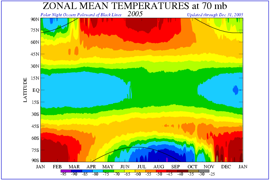
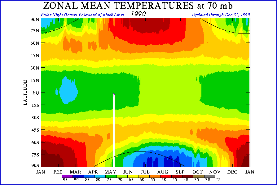
This trend can be seen around the tropics at the 50 and 70 hPa levels at this website. Take a look at the changes that have taken place since the mid 90's compared to earlier years at the 9th section down.
"Time vs. latitude of the zonal mean temperature on the 50 mb pressure surface"
http://www.cpc.ncep.noaa.gov/products/s ... olar.shtml
The dark green and light blue is now staying around more consistently through the summer at the 70 hPa level.
2005 -
http://www.cpc.ncep.noaa.gov/products/s ... 0_2005.gif
1990 -
http://www.cpc.ncep.noaa.gov/products/s ... 0_1990.gif
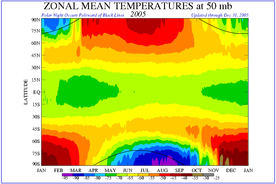
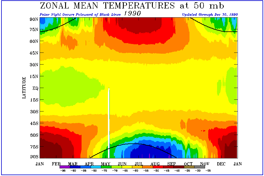
The light and dark greens, which represent colder temperatures, are also showing up much more frequently in the 50 hPA level around the tropics.
2005 -
http://www.cpc.ncep.noaa.gov/products/s ... 0_2005.gif
1990
http://www.cpc.ncep.noaa.gov/products/s ... 0_1990.gif
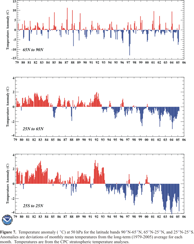
A very good graphical time series of the temperature anomalies, since 1978 , at the 50 hPa level between 25N- 25S can be seen at this URL from the CPC's 2004-05 winter bulletin.
http://www.cpc.ncep.noaa.gov/products/s ... ure_07.gif
(Climate Prediction Center's Winter bulletin Archive)
http://www.cpc.ncep.noaa.gov/products/s ... hives.html
You can see when you look at the above graph , 25S -25N, and even the 25N -65N, that the temperature anomaly changes, at the 50 hPa level, almost coincided exactly with the change in the AMO.
The continual presence of the stratosphere's positive temperature anomalies changed just prior to the AMO's favorable positive change around 1995. The coolest stratospheric temperature anomalies have occurred during the past two years and we have seen the highest level of tropical activity during the past two seasons. ( As well as a rise in the sea surface temperatures also. See more below)
These changes also coincide with the 30 hPa's late Final Warming (Springtime changeover) at the north pole that I mentioned in the beginning of this discussion. Plus lets not forget as well about the developing late trend seen since around 1995 occurring in the springtime changeover at 30 hPa level between 50N - & 80N...temperature gradient related ( Figure 10 graph above, aqua, red and black lines, moving linear trend)
These coupled changes are not a coincidence by any stretch of the imagination. Many research articles have been written about the feedback between the North Atlantic Oscillation (NAO) and the seas surface temperatures in the Atlantic. The Artic Oscillation (AO) is basically the same as the NAO almost and they pretty much go hand and hand. The AO is an important influential player with the Aleutian Low in regards to it's placement and intensity level. Most major teleconnections all intermingle with each other and these URL's talk about some of this.
http://www.nwra.com/resumes/baldwin/pub ... 99_JGR.pdf
http://www.pmel.noaa.gov/foci/ecotrends ... or2001.pdf
http://www.met.rdg.ac.uk/cag/publicatio ... broenn.pdf
So we know there were a some pattern changes going on in both the stratosphere and the Atlantic prior to the last two AMO flip flops. (71 & 95)
Another pattern change was also occurring and this discussion, which may be part of a lengthier one, shows two important graphs in section 5.3.2
The graphs I am referring to are 5.4a and 5.4b
http://www.clivar.com/publications/othe ... ip/pd1.htm
These show the total number of North Atlantic low pressure systems, 950 mb and lower, from November through March, between the winters of 1955-56 and 95-96. They also show the NAO trend during these same years right below the first graph.
One can clearly see that the number of storms had started to bottom out in the late sixties and it bottomed out in 1969. This lower number of strong low pressure systems preceded the AMO change to negative (Less hurricane activity) right before 1971 and the number of intense winter storms increased right before the AMO changeover to positive (More hurricane activity) right before 1995.
So we have another pattern change that coincided with the stratosphere's temperature changes and the AMO.
One has to read up extensively between all of the northern hemisphere's's teleconnection feedbacks/correlations to understand what is possibly occurring here.
NAO, and the AO phases have a constant feedback relationship with the Pacific's oceanic and atmospheric teleconnections. The strength of the NAO and the AO is related to the state and strength of the Aleutian Low. The latter's placement is extremely important and it is influenced by events like the El Nino and La Nina. It has a tendency to move more south and east during El nino's and the opposite occurs during a La Nina.
This can then have a feedback with the NAO & AO intensity. The NPI (North Pacific Index ) is also involved in these relationships along with the PNA (Pacific North American) and let's not forget the PDO. (Pacific Decadal Oscillation)
The two different ENSO phases, El Nino and La Nina ,are somewhat influenced by the negative /positive state of the PDO. The PDO loads the dice , decadal wise , on the amount of times each one may occur over an approximate 20 year period. So one can see how complicated all the interactions are.
A good research discussion on the feedbacks between the Pacific and the Atlantic can be seen at this URL.
"Seesaw fluctuation in ozone between the North Pacific and North Atlantic"
http://fmiarc.fmi.fi/candidoz/docs/seesaw_Orsolini.pdf
The winter time state of both the Aleutian low and the NAO have an effect upon Canadian Warming (CW) or vice versa. The CW was talked about in both stratosphere research papers above but not the Aleutian Low connection. Both the NAO and the QBO were mentioned.
The frequency of CW's in early winter, November & December ( Which is when they only can occur) along with some Major Warmings in January, occurred just prior to the group of changes around 1971. So both the frequency of CW's and the early arrival of the Final Warming seem to have a role in the AMO wanting to be in a negative state while the absence of CW's during early winter along with the late Final Warming changeover seems to load the dice towards a positive AMO.
I believe these wintertime events along with some other changes pushed the AMO into the negative state. The exact opposite, colder wintertime temperatures, coincided with the AMO changeover to positive. Other variables like the strength and timing of the directional changes/peaks (East/West) of both 30 & 50 mb QBO's play a major role also.
30 mb QBO URL
ftp://ftp.ncep.noaa.gov/pub/cpc/wd52dg/ ... .u30.index
50 mb QBO
ftp://ftp.ncep.noaa.gov/pub/cpc/wd52dg/ ... .u50.index
Now I think I have done a pretty good job staying away from the space weather effect into all of this but I want to touch base on this matter now since it is so influential before I end this discussion . I also am going to post some tidbits/formulas to use when trying to forecast weather/climate events.
I believe the sunspot cycle's , Hale Cycle, which takes approximately 22 years to occur, is a dominant force behind the cyclical nature of PDO phases. This is why it's phases tend to be longer then it's brethren in the tropics, the ENSO (El Nino /La Nina)
The latter seems to be influenced more by the 11 year sunspot cycle. (Which is only half of the Hale Cycle)
The relationship between the ENSO and the 11 year sunspot sunspot cycle seems to be magnetically controlled and this seems to have an influence upon the manner in which the atmosphere responds to the forcing that occurs between the QBO phases and stratosphere or the vice versa.
Many research papers are out there in reference to the space weather effect upon the QBO and how it's directional phases matter. Here are just a few URL's
http://www1.ig.cas.cz/Rocenka93-4/pychai.htm
http://www.copernicus.org/EGS/egsga/nic ... ai1024.pdf
http://lasp.colorado.edu/sorce/2004Scie ... Hameed.pdf
The polarity of the sun's poles also play a role in the amount of GCR (Galatic Cosmic Rays) levels that reach the earth. GCR's are very energetic and their possible relationship can not be taken lightly.
Ed Mecurio has a simplistic discussion that touches base with , solar polarities (Parallel and anitparallel) and GCR levels. He explains things rather well , shows diagrams , graphs etc.. I posted a URL to a similar discussion of his in the Global Weather Forum a while back.
http://www.hartnell.cc.ca.us/faculty/mercurio/gcr2.html
Some other possible contributing factors involve particle levels and how they might interact with the earth's electrical environment by way of magnetic field vectors.
I have previously given out some of these URL's to research papers by individuals like , Tinsley and Baranyi, in reference to the solar wind and the interplanetary magnetic field and how magnetic field vectors seem to play a role in determining where on earth these space weather -atmospheric relationships might occur.
http://www.utdallas.edu/dept/physics/Fa ... in_rev.pdf
http://www.utdallas.edu/dept/physics/Fa ... mtrans.pdf
http://fenyi.sci.klte.hu/publ/Birmingham2000.pdf
http://fenyi.sci.klte.hu/solspa2000.html
http://fenyi.solarobs.unideb.hu/publ/Praga2002.pdf
The 30 & 50 hPa QBO's seem to be the atmosphere's influential players, short term wise, as far as the ENSO phases. At least from the standpoint of using them as indices. While the 30 hPa seems to have more control over the stratosphere's warming/cooling (This occurs during directional changes) the direction of 50 hPa seems to be the determining factor as to whether or not a La Nina or El Nino is going to develop. (Influences SOI more)
Of course the temperature of the 30 hPa must also be crossed referenced with this to complete the formula. (Formula at end of discussion below.)
One can watch either the QBO's behavior, or the stratosphere's, to get an idea of what the other one is doing. The ability to know well in advance of what the QBO's phases will be or what the space weather will be like can give you a good idea of how the Southern Oscillation is going to behave down the road ...short term wise. Or any weather pattern for the most part.
The 11 year behavior of the sunspot cycle and it's relationship with the QBO/stratosphere/ENSO can explain why the PDO can be extended sometimes beyond the approximate 22 year Hale Cycle. A strong ENSO can cause temporary changes in the both the Cold Tongue around the tropics and the PDO. So a forecasted PDO changeover may not really take hold until after certain space weather conditions have come and gone.
The PDO will eventually then enter it's proper state, in regards to the solar Hale Cycle, there by statistically limiting the chances of a non conforming ENSO phase.
Earlier on I mentioned the importance of the stratospheric temperatures at the 50 hPa level between 25S -25N and it's possible forcing of the AMO changes. Well the overall SST's in the tropics worldwide between 10S-10N also seem to have a relationship with these stratosphere temperature anomalies.
Here is a URL that shows the Global temperature anomalies for the above areas. They are in the far right column.
http://www.cpc.ncep.noaa.gov/data/indic ... tl.indices
One can clearly see that the SST temperature are inverted to the stratosphere anomalies. Bottom graph.
http://www.cpc.ncep.noaa.gov/products/s ... ure_07.gif
I know I have covered a large amount of material but I hope this might possibly shed some light on some of the possible causes to the recent increased hurricane activity this year as well as the past decade.
Just remember this solar cycle is much different then previous ones. The interplanetary magnetic field (IMF) changes throughout the solar cycle and the earth's electrical environment reacts differently to these changes because of the way it receives it.
Strong solar eruptions, like the ones that occurred throughout this past summer and fall, brought along strong electron and proton particle rises to the earth's environment.
Important Particle Factors:
The differential electron flux in the 38-53 range is very important. Strengthening of storms seem to occur if it rises above the 0.00e+03 level.
ACE EPAM data for July -Sept show the high levels. It's the column under ELECTRONS 38-53 ....left side
http://www.sec.noaa.gov/ftpdir/lists/ac ... pam_1h.txt
http://www.sec.noaa.gov/ftpdir/lists/ac ... pam_1h.txt
http://www.sec.noaa.gov/ftpdir/lists/ac ... pam_1h.txt
The other electron fluence that is important is the > 2 MeV level. This is related to the overall state of the earth's magnetic field and what type of geomagnetic activity has been occurring. ( DST Index also)
The threshold of 0.0e+07 seems to be very important from what I have observed over the years. Storm intensification seems to increase during the days when the peaks are considerably above this.
This explains why we can see certain kinds of increased storminess during the times when solar eruptional activity is limited.
The solar wind/IMF is always interacting with the earth's magnetic field. This interaction can be seen here at HARP. A very disturbed H- Component will guarantee rises in the > 2 MeV electron level.
Daily > 2 MeV averages can be seen here from October 1st on
Column all the way to the right.
http://www.sec.noaa.gov/ftpdir/indices/ ... Q4_DPD.txt
July-Sept
http://www.sec.noaa.gov/ftpdir/indices/ ... Q3_DPD.txt
April-June
http://www.sec.noaa.gov/ftpdir/indices/ ... Q2_DPD.txt
All yearly data since 1994 can be seen here under Daily Particle Indices
http://www.sec.noaa.gov/ftpmenu/indices ... dices.html
Energetic proton particles seem to sometimes quiet hurricane activity and their overall strength seems to determine whether or not the SOI will go positive or negative.
Extremely strong proton readings, above the 3.0e+08 (>1 MeV proton Fluence) , along with strong geomagnetic storms (Forbush decreases/less GCR"s) seem to enhance La Nina conditions while energetic values between 3.0e+06 - 3.0+08, and low geomagnetic activity (Increased GCR's) seem to enhance El Nino conditions.
The effect has a lag time that seems to depend upon the strength of the geomagnetic activity and quite possibly the current phase of the Madden Julian Oscillation (MJO) .
Under Daily Particle Indices
http://www.sec.noaa.gov/ftpmenu/indices ... dices.html
I believe these strong particle values, which were brought upon by the increased solar eruptions throughout this summer and fall , have played a major role in the intensification of all of these tropical systems this year.
The extremeness of these particle levels definitely increased ionization within the ionosphere. This would have coupled with the lower atmosphere, there by possibly influencing storm intensification.
These increased particle levels may also be playing a role in the diminishing ozone levels. Many research studies have linked this to ozone losses.
http://oea.larc.nasa.gov/news_rels/2000/00-091.pdf
http://www.spacedaily.com/news/carbon-01f.html
http://www.crawford2000.co.uk/ozone.htm
These changes may also be influencing hurricanes in ways that we do not quite understand yet. One could speculate about an atmospheric coupling with the stratosphere/ionosphere via ozone/electron levels.
http://www.livescience.com/forcesofnatu ... ozone.html
Space weather is very important and if you believe that it can have an effect upon the stratosphere, during the winter months, at the higher latitudes , then you may want to think about the delayed feedbacks between the poles and the tropics via the stratosphere and the troposphere.
Formulas for El Nino / La Nina Phases and other Info :
SOI Data:
Monthly values since 1887 can be seen under last files heading
"Monthly SOI Phase 1887-1989 Base"
They also have some daily SOI data here.
http://www.longpaddock.qld.gov.au/Seaso ... DataFiles/
Stratosphere Data:
Current Stratosphere temperatures at different latitudes and hPa
http://www.cpc.ncep.noaa.gov/products/s ... mperature/
Many different kinds of historical stratospheric data can been found at this
data base URL. But you have to check the boxes and time frames for the data you want.
http://code916.gsfc.nasa.gov./Data_serv ... _data.html
50 hPa QBO relation (direction matters)
30 hPa stratosphere (Temperatures anomalies between 60-90N matter)
Approximate 11 year cycle ( Solar maximum to maximum, Magnetic Polar cycle)
2000- until next solar maximum.
50 hPa QBO (West Phase)
30 hPa Stratosphere temperatures 60-90N
Warm = La Nina
Cold = El Nino
50 hPa QBO (East Phase which is the current phase)
30 hPa Stratosphere Temperatures 60-90N
Warm = El Nino
Cold = La Nina
The exact opposite formula should be used between the maximums of 12/1989 - 5/2000 (Although one must consider that the poles do not change their polarity exactly around solar maximum. More later)
The current formula used now would have been used between 12/79 -12/89.
Weather Note: The development of the EL Nino this cycle should bring cold weather to the Northeast and possibly other areas as well. This is most likely related to the feedbacks between the above elements and the NAO/AO
Remember the East QBO phase and warm stratosphere (30 hPa 60-90N)supports El Nino conditions (I am basically referring to negative SOI here). The Washington DC area has usually experienced opposite temperature anomalies during this time.
During the west phase everything is the opposite and the temperature pattern down below goes hand in hand with the stratosphere's temperature. So a cold stratosphere will equal cold temperatures for the Washington DC area.
The exact opposite happened last sunspot cycle. Extremely warm conditions preceded the 1997-98 El Nino during the winter of 1996-97. The development of the La Nina during May 1998 is rather tricky and it developed very late in the season....space weather related.
The two strongest El Ninos, of 1982-83 and 1997-98, meet the criteria of the above methodology and so do the other ENSO phases.
QBO Note: East 30 hPa usually bring along a warming trend in this level of the stratosphere as it weakens and the western QBO brings along colder temperatures.
One must also take into consideration what the 50 hPa QBO, can have upon the stratosphere's temperature trend right after it peaks or while it is changing direction .
The 50 hPa influence can be seen around the time of the 1998 La Nina and also around the time of the development of the 2002-03 weak to moderate El Nino.
The previous winter seems to set the table for the ENSO phase. An El nino started to develop in early 2002 after a 30 hPa warming trend (60-90N ) occurred during the winter of 2001-2002 while we were under the influence of an eastern QBO (50 hPa).
The negative SOI trend weakened somewhat as the 50 hPa QBO went westward but certain space weather parameters (Low geomagnetic activity, certain particle levels) held it mildly together.
Space Weather Note:
Take a look at this URL that shows smoothed geomagnetic activity numbers. All the way to the right.
http://www.sec.noaa.gov/ftpdir/weekly/RecentIdices.txt
You can clearly see how the rise and fall of the smoothed monthly geomagnetic activity averages (13 months) coincides with SOI changes.
The El Nino developed in early 1997 as the activity levels were bottoming out. It weakened and the La Nina developed when the activity started to rise in early 1998. The positive SOI waxed and waned for the next couple of years in tandem with these ups and downs.
The El Nino of 2002 developed during the geomagnetic lull and it weakend as the activity picked up. The El Nino pattern that developed last fall/winter (California rains, strong negative SOI) developed while the geomagnetic activity dipped again and the most recent change, to weak La Nina conditions, has occurred during the time of the increased geomagnetic activity /Strong Proton flares.
The geomagnetic activity changes cause fluctuations in the GCR levels and electron levels. These can have an effect upon the QBO and other elements in the atmosphere. Tinker around with the dates of two consecutive QBO phases or some other atmospheric parameters and see how the ups and downs of the GCR levels effect the peaks and valleys.
Cosmic Ray Monitor
http://cosmicrays.oulu.fi
The current state of the QBO's , 30 hPa and the 50 hPa, are going to make it a liitle hard for a strong ENSO development at this stage of the solar cycle. The 30 hPa is changing direction more around January while the 50 hPa is making a directional change in late spring to early summer.
This tends to lean towards strong winter time ENSO phase influences, like last winter, but weak summertime influences. Hence the possibility of stronger Atlantic hurricane activity.
The directional change of the QBO 50 hPa during May & June seems to have an influence upon the tropics. An increase in almost all areas, storm totals, hurricanes , major hurricanes, landfalls, etc... seem to increase during the years of a late spring to early summer directional change since 1979. (Probably AMO related)
I posted some statistics about a week ago in reference to these years. 1985, 1989, 1990, 1996,1997, 1998, 2003, 2004, 2005.
I eliminated the 1997 year because of the strength of the EL Nino.
http://www.storm2k.org/phpbb2/viewtopic.php?t=78147
This is my last subject matter and I have written about it many times before and part of this was in local newsprint last March. Many individuals in both the science and meteorological community received an e-mail discussion from me last winter in reference to this. Some of TWC's OCM's and experts also received this.
I know they probably scoffed at this but it HAS ONCE AGAIN proven to be true. All of the above discussions are interrelated to how the earth's environment , and the solar system for that matter, responds to the Solar magnetic field changes.
Research has shown that the sun has many different cyclical lengths, regarding it's magnetic field strength. The strength of the sun's poles is extremely important to both it's own activity level and to the earth's weather/climate patterns.
When the sun is most active, sunspot wise, X-ray flaring, eruptions etc... it's poles are actually weaker or close together in strength value. This is why we see increased solar activity around solar maximum. The poles are changing polarity and the lower latitudes are showing the effects...hence increased activity.
But what the solar community has failed to realize, until maybe recently, after my continual comments over the years within forums like this or e-mail discussions, and calls out to the Space Environment Center. Wilcox Observatory etc.. is that you can STILL HAVE major activity well after solar maximum (Like we have been witnessing) when the polar values are very low and at similar values.
The date of solar maximum is MEANINGLESS if the poles are behaving in a different manner compared to previous cycles. Now I know this theory of mine will appear in some science journals in the near future but I dare anyone to find this anywhere on the Internet or in any science journal that talks about this particular relationship.
Why bring this up in this forum? Well the waxing and waning of the polar strength, in both hemisphere's seems to control almost everything within the earth environment by basically loading the dice for certain space weather events to occur. This then loads the dice here on earth for certain events to occur more frequently here on earth. Or probably any other planet for that matter.
If you look at the waxing and waning of the polar strength values here at the Wilcox Observatory you can see patterns with the SOI and several other things also. Look at when they change dominance over each other or when they change polarity about every 10-11 years. (QBO phases matter)
I am referring to the 20 nhz low passed filtered values all the way to the right.
http://soi.stanford.edu/~wso/Polar.ascii
You can see how close the values have been the past few years and when they have gotten very close (1-3 digits) we have seen atmospheric responses and all types of space weather/solar parameters have increased dramatically around these close polar values.
You can view space weather data here.
http://www.sec.noaa.gov/ftpmenu/indices.html
You can see how solar flaring increases (X-class is strongest, then M-Class) under Daily Solar Data
Proton particle extreme's , like last January 2005, which was the strongest proton flare since October 1989, under the
Daily Particle Data. January-March 2005.
And the increase in strong geomagnetic storms under Daily Geomagnetic Data.
All of these extremes influence us and if you can forecast the polar changes, and their strength values, then you can forecast certain events well in advance within a certain realm of accuracy.
Solar Forecast:
Right now the southern hemisphere is going to be dominant, sunspots flaring etc... until the southern hemisphere's pole strengthens. It would not surprise me to see almost no magnetically complexed sunspot groups in the northern hemisphere, or even a frequent spotless days in the northen hemisphere , for quite a while, until the south pole starts to strengthen.
We should see a fairly large , magnetically complexed sunspot region , in the Southern Hemisphere, near the central meridian, around December 6th. So increased solar flaring will probably occur.
The nature of the overall space weather intensity level will continue in an approximate 130-170 day cycle until the north pole becomes much stronger than the south. OTOH if the south poles keeps weakening and it gets closer to the "0" filtered value than all bets are off. I have no idea what will occur than. This could be very bad.
We would have then have two poles with the same magnetic polarity, like we can see at solar maximum some times. But this would be different now since we are so far way from solar maximum. This is different due to the current state of the IMF.
This would mean that the potential energy would never be dissipated like it usually does around maximum because of the overall increased sunspot group activity. That spreads all of the energy out over an extended period of time.
So everything would most likely come to a head in this particular scenario and we would see intense cyclical activity (Every 130-170 days). So extremely strong flaring/particle events/eruptions may be seen. I would guess that this could lead to some strong wave action/feedbacks in the atmosphere.
Jim
Stratosphere , Ozone, and how this effects the AMO cycle
Moderator: S2k Moderators
Forum rules

The posts in this forum are NOT official forecasts and should not be used as such. They are just the opinion of the poster and may or may not be backed by sound meteorological data. They are NOT endorsed by any professional institution or STORM2K. For official information, please refer to products from the National Hurricane Center and National Weather Service.
-
Jim Hughes
- Category 3

- Posts: 825
- Joined: Sun Jul 24, 2005 1:52 pm
- Location: Martinsburg West Virginia
Stratosphere , Ozone, and how this effects the AMO cycle
Last edited by Jim Hughes on Wed Nov 16, 2005 7:20 pm, edited 1 time in total.
0 likes
-
Tampa Bay Hurricane

- Category 5

- Posts: 5598
- Age: 38
- Joined: Fri Jul 22, 2005 7:54 pm
- Location: St. Petersburg, FL
-
Jim Hughes
- Category 3
- Posts: 825
- Joined: Sun Jul 24, 2005 1:52 pm
- Location: Martinsburg West Virginia
Tampa Bay Hurricane wrote:After reading your article, I feel your information about looking at the stratosphere as an important component to forecasting could be a very powerful method of forecasting. Excellent
Thanks Tampa Bay. I thought you would be one of the ones who would find this compelling. I sort of acted like a politician, who adds on some pork spending for his home state by throwing in the space weather stuff but I felt like sharing this also.
It may not be exactly right but I feel that allot of what I wrote about , space weather wise, is on the right track. I am basically building a foundation so that a younger generation , like your own, can build on it.
I have always believed that we needed to monitor the stratosphere more closely and the recent surge in Atlantic hurricane activity suggests to me that this is even more important then I had previously thought.
Jim
0 likes


Wow, what an interesting read on how everything is interconnected! This has definitely changed my opinion on how much global warming is to blame. After you study all these other factors it makes me realize something more powerful is at work.
I was wondering if you could post some good links about space weather for beginners like me? Preferably a bit laymen but with basic physics included on the energy particles and solar polarity. I've been studying the synoptic-scale of things lately trying to understand what's behind the "hyperactive" tropical season. Also been searching for the reason behind the drought in the West and how do all these oscillations play into that. I'm not one to listen to these environmentalists claiming Westerners have depleted the water resources as the cause. All the hype and no clear-cut answers.
You've made me realize that we humans are just minute specks on the Earth that can't change the weather only the local environment. You put new meaning as to how much the Sun affects everything. Thanks for letting us understand the bigger picture.
0 likes
-
terstorm1012

- S2K Supporter

- Posts: 1314
- Age: 44
- Joined: Fri Sep 10, 2004 5:36 pm
- Location: Millersburg, PA
-
Jim Hughes
- Category 3
- Posts: 825
- Joined: Sun Jul 24, 2005 1:52 pm
- Location: Martinsburg West Virginia
cgstorm5 wrote:Wow, what an interesting read on how everything is interconnected! This has definitely changed my opinion on how much global warming is to blame. After you study all these other factors it makes me realize something more powerful is at work.
I was wondering if you could post some good links about space weather for beginners like me? Preferably a bit laymen but with basic physics included on the energy particles and solar polarity. I've been studying the synoptic-scale of things lately trying to understand what's behind the "hyperactive" tropical season. Also been searching for the reason behind the drought in the West and how do all these oscillations play into that. I'm not one to listen to these environmentalists claiming Westerners have depleted the water resources as the cause. All the hype and no clear-cut answers.
You've made me realize that we humans are just minute specks on the Earth that can't change the weather only the local environment. You put new meaning as to how much the Sun affects everything. Thanks for letting us understand the bigger picture.
Sorry for the late response cgstorm5. This URL leads you to and Educational Outreach from the Space Environment Center. It should help you understand things slightly better.
http://www.sec.noaa.gov/Education/index.html
I will be doing a follow up during the week sometime on two additional variables that seem to be having an effect. I came to the conclusion a few weeks ago , while I was gathering some data /thoughts, that there could be three main things to this season, variable/teleconnection wise.
One is the AMO which has many different contributing parts . The other two may be related to why the ratio's seemed to have increased. I am referring to the number of hurricanes/majors and all of these GOM landfalls. Especially the majors.
Jim
0 likes
-
Jim Hughes
- Category 3
- Posts: 825
- Joined: Sun Jul 24, 2005 1:52 pm
- Location: Martinsburg West Virginia
-
Jim Hughes
- Category 3
- Posts: 825
- Joined: Sun Jul 24, 2005 1:52 pm
- Location: Martinsburg West Virginia
Re: Stratosphere , Ozone, and how this effects the AMO cycle
Jim Hughes wrote:
Formulas for El Nino / La Nina Phases and other Info :
SOI Data:
Monthly values since 1887 can be seen under last files heading
"Monthly SOI Phase 1887-1989 Base"
They also have some daily SOI data here.
http://www.longpaddock.qld.gov.au/Seaso ... DataFiles/
Stratosphere Data:
Current Stratosphere temperatures at different latitudes and hPa
http://www.cpc.ncep.noaa.gov/products/s ... mperature/
Many different kinds of historical stratospheric data can been found at this
data base URL. But you have to check the boxes and time frames for the data you want.
http://code916.gsfc.nasa.gov./Data_serv ... _data.html
50 hPa QBO relation (direction matters)
30 hPa stratosphere (Temperatures anomalies between 60-90N matter)
Approximate 11 year cycle ( Solar maximum to maximum, Magnetic Polar cycle)
2000- until next solar maximum.
50 hPa QBO (West Phase)
30 hPa Stratosphere temperatures 60-90N
Warm = La Nina
Cold = El Nino
50 hPa QBO (East Phase which is the current phase)
30 hPa Stratosphere Temperatures 60-90N
Warm = El Nino
Cold = La Nina
The exact opposite formula should be used between the maximums of 12/1989 - 5/2000 (Although one must consider that the poles do not change their polarity exactly around solar maximum. More later)
The current formula used now would have been used between 12/79 -12/89.
Jim
This is a portion of my longer discussion from last November. I think it is located almost halfway through.
I know there has been many talks about whether there is an EL Nino actually forming or even how strong it is going to end up being but most people do not understand that the recipe for this EL Nino was already in the making back in January of this very same year.
Most MET's should know about the strong stratospheric warming that occurred this past winter. It was mentioned and discussed around most weather forums last winter and even the NWS talked about it. (I used it to forecast a snowstorm last February. )
Well this warming meant that the La Nina would go poof and that the EL Nino conditions would start to show up.
I wrote about this very stuff last November in this discussion and I gave out a specific formula in regards to the QBO direction and the stratosphere temperature anomaly and the solar cycle.
(I said East QBO and warm = El Nino conditions
So this was not some lucky stab that I have been putting out there in regards to this developing El nino. And this was no just post analysis either in regards to the subsurface warming or the extreme SOI readings.
We can all argue about the relationship and how does this exactly effect the ENSO but nobody can deny that I did not forecast this EL Nino by use of this forecasting methodology / guidelines.
Some of you are going to have to consider this stuff if we are ever going to properly get a grip on long term forecasting.
Ernesto and Florence have followed my forecasting rules regarding possible space weather influences .
I also briefly talk about these important variables in this discussion and in many other discussions that I wrote last year at Storm2k. Most regulars and MET's know of them and some thought they were controversial.
I will admit that they are controversial but they also seem to have merit. And continual denial does not help the public at large. There is a science here and it has some foundation. The exact physics behind it are missing though. So a huge wall keeps some from recognizing it's possible potential here.
I just wish these internal politics would go wayside. Preconceived belief systems are what's really keeping this from gaining a foothold.
Jim
0 likes

-
MetSul Weather Center
- Tropical Storm

- Posts: 103
- Joined: Wed Dec 06, 2006 9:08 pm
- Location: São Leopoldo, Brazil
-
Jim Hughes
- Category 3
- Posts: 825
- Joined: Sun Jul 24, 2005 1:52 pm
- Location: Martinsburg West Virginia
Thank you for the kind words MetSul Weather Center. I have always tried to think outside the box and to look into other ways to long term forecast . I believe the behavior of the stratosphere, and the cyclical timing of certain things, is very important in the overall scheme of things. I also believe in the possible space weather forcing upon alot of oceanic and atmospheric teleconnections.
All of this is basically an unknown field in many ways. So things can only get better as more and more research goes into this type of forecasting.
All of this is basically an unknown field in many ways. So things can only get better as more and more research goes into this type of forecasting.
0 likes

Good post Jim! I always felt there were many factors for hurricanes. I have found a positive AMO favors more hurricanes than a negative AMO. I never thought of the stratosphere playing a role. I always wondered why the 1977 hurricane season was quiet. It was below average in all the basins and in some cases, one of the quietest, especially in the ATL and EPAC. Is it possible that what you mentioned could explain the inactiveness of 1977?
0 likes
-
wxmann_91

- Category 5
- Posts: 8013
- Age: 34
- Joined: Fri Jul 15, 2005 2:49 pm
- Location: Southern California
- Contact:
Great post Jim... did you post this in "the other board"?
I really haven't had a chance to digest all of this, but I know you mentioned how the Atlantic indexes influence the Pacific ones. I'm not sure if you touched base with this or not, but I did notice that there is a lag time between the AMO switching and the PDO switching. The correlation isn't all that strong but it's there: these two indexes don't want to be in the same phase.
I really haven't had a chance to digest all of this, but I know you mentioned how the Atlantic indexes influence the Pacific ones. I'm not sure if you touched base with this or not, but I did notice that there is a lag time between the AMO switching and the PDO switching. The correlation isn't all that strong but it's there: these two indexes don't want to be in the same phase.
0 likes
-
Jim Hughes
- Category 3
- Posts: 825
- Joined: Sun Jul 24, 2005 1:52 pm
- Location: Martinsburg West Virginia
wxmann_91 wrote:Great post Jim... did you post this in "the other board"?
I really haven't had a chance to digest all of this, but I know you mentioned how the Atlantic indexes influence the Pacific ones. I'm not sure if you touched base with this or not, but I did notice that there is a lag time between the AMO switching and the PDO switching. The correlation isn't all that strong but it's there: these two indexes don't want to be in the same phase.
Thanks wxmann_91. No I did not post it over at eastern. But I did post a link to this shortly after I joined there. I did get some minor feedbacks via PM's from over there. Even by some MET's. Some of the regulars over there are banned from here so they never got a chance to read it.
I wish all the links still worked since it's rather long and confusing. Them not working is only going to make harder to follow my thoughts.
0 likes
-
MetSul Weather Center
- Tropical Storm
- Posts: 103
- Joined: Wed Dec 06, 2006 9:08 pm
- Location: São Leopoldo, Brazil
Jim Hughes wrote:Thank you for the kind words MetSul Weather Center. I have always tried to think outside the box and to look into other ways to long term forecast . I believe the behavior of the stratosphere, and the cyclical timing of certain things, is very important in the overall scheme of things. I also believe in the possible space weather forcing upon alot of oceanic and atmospheric teleconnections.
All of this is basically an unknown field in many ways. So things can only get better as more and more research goes into this type of forecasting.
Jim
We use to say during our lectures to clientes. "You do not believe in space forcing in climate ? Just think on the influence of the tiny moon we have in the sea tides. Now think the influence of the sun - huge - in our atmosphere.
A very interesting paper:
ABSTRACT:
The precisely dated isotopic composition of a stalagmite from Spannagel Cave in the Central Alps is translated into a highly resolved record of temperature at high elevation during the past 2000 yr. Temperature maxima during the Medieval Warm Period between 800 and 1300 AD are in average about 1.7°C higher than the minima in the Little Ice Age and similar to present-day values. The high correlation of this record to d14C suggests that solar variability was a major driver of climate in Central Europe during the past 2 millennia.
Mangini, A., C. Spötl, and P. Verdes. 2005.
Reconstruction of temperature in the Central Alps during the past 2000 yr
from a d18O stalagmite record.
Earth and Planetary Science Letters, Vol. 235, Issues 3-4, Pages 741-751,
15 July 2005. doi:10.1016/j.epsl.2005.05.010
Data from this paper available at NCDC's NOAA website:
ftp://ftp.ncdc.noaa.gov/pub/data/pal...nnagel2005.txt
0 likes
-
Jim Hughes
- Category 3
- Posts: 825
- Joined: Sun Jul 24, 2005 1:52 pm
- Location: Martinsburg West Virginia
MetSul Weather Center wrote:Jim Hughes wrote:Thank you for the kind words MetSul Weather Center. I have always tried to think outside the box and to look into other ways to long term forecast . I believe the behavior of the stratosphere, and the cyclical timing of certain things, is very important in the overall scheme of things. I also believe in the possible space weather forcing upon alot of oceanic and atmospheric teleconnections.
All of this is basically an unknown field in many ways. So things can only get better as more and more research goes into this type of forecasting.
Jim
We use to say during our lectures to clientes. "You do not believe in space forcing in climate ? Just think on the influence of the tiny moon we have in the sea tides. Now think the influence of the sun - huge - in our atmosphere.
A very interesting paper:
ABSTRACT:
The precisely dated isotopic composition of a stalagmite from Spannagel Cave in the Central Alps is translated into a highly resolved record of temperature at high elevation during the past 2000 yr. Temperature maxima during the Medieval Warm Period between 800 and 1300 AD are in average about 1.7°C higher than the minima in the Little Ice Age and similar to present-day values. The high correlation of this record to d14C suggests that solar variability was a major driver of climate in Central Europe during the past 2 millennia.
Mangini, A., C. Spötl, and P. Verdes. 2005.
Reconstruction of temperature in the Central Alps during the past 2000 yr
from a d18O stalagmite record.
Earth and Planetary Science Letters, Vol. 235, Issues 3-4, Pages 741-751,
15 July 2005. doi:10.1016/j.epsl.2005.05.010
Data from this paper available at NCDC's NOAA website:
ftp://ftp.ncdc.noaa.gov/pub/data/pal...nnagel2005.txt
I am a very big believer in the space weather forcing upon our climate or possibly even certain weather patterns and many people around here have read some of my previous discussions about this.
I did a search for your company and some space weather items came up so I am glad to see that you follow this subject matter.
I think there may be something else of mine that you might want to read about. I wrote the discussion this past August over in another weather forum. I called it the PET Cycle.
It dealt with the cyclical nature of the Polar Eurasian teleconnection. I based this theory on the possible forcing of strong forbush decreases that occur during the rise toward solar maximum. The solar cycle polarity seems to matter within the whole scheme of things.
I show how the negative and positive anomalies of the Polar Eurasian teleconnection seem to have a preferred state during certain cycles and how it has flip flop during the past 50 plus years.
I also show how the North Pole ozone levels have fluctuated with this cycle and so have some of the hPa height anomalies. Also some stratopsheric timing changes in regards to when the ozone hole shrinks below a certain criteria...etc...
Your knowledge of space weather would help immnensely in understanding this theory. Several MET's replied to the post but most were not knowledgeable about the space weather variables.
I will PM you with the URL link since we are not allowed to post links to other forums here.
Jim
0 likes
Who is online
Users browsing this forum: No registered users and 81 guests