


Moderator: S2k Moderators


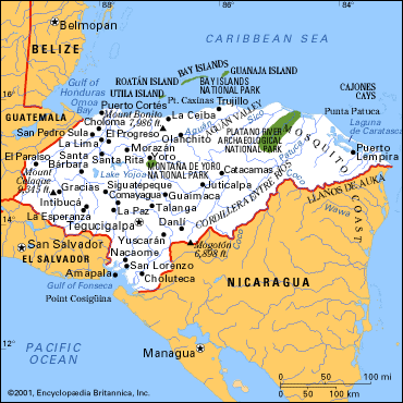
Aric Dunn wrote:I have two small problems with the low center being where they say it is ...... and not farther south.. two reports in belize here http://weather.noaa.gov/weather/current/TLPC.html and here http://weather.noaa.gov/weather/current/TLPL.html both have An east component to the winds .. thats a problem ..... if the center is north of belize than they would not have E and even eSe as in those reports
now given that there are probably some issues with the reporting stations there in belize one should not completly rely on these observations alone.. but its somehthing i m looking into .. because... position of this thing is key .. to far north shear .. south upper ridging and more favorable ..
Thunder44 wrote:Aric Dunn wrote:I have two small problems with the low center being where they say it is ...... and not farther south.. two reports in belize here http://weather.noaa.gov/weather/current/TLPC.html and here http://weather.noaa.gov/weather/current/TLPL.html both have An east component to the winds .. thats a problem ..... if the center is north of belize than they would not have E and even eSe as in those reports
now given that there are probably some issues with the reporting stations there in belize one should not completly rely on these observations alone.. but its somehthing i m looking into .. because... position of this thing is key .. to far north shear .. south upper ridging and more favorable ..
That's because you don't have actual closed LLC yet. If you look at visible imagery you can see more low-level cyclonic turning in clouds obs over NE tip of Yucatan now. That is the low, then you have a surface trof along the coast, extending down to the Honduras. It's more of an inverted surface trof or elongated area of low pressure. On the west of the side of the trof you
boca wrote:Where exactly is the low level turning, down by Roatan Island off Honduras?
Aric Dunn wrote:Thunder44 wrote:Aric Dunn wrote:I have two small problems with the low center being where they say it is ...... and not farther south.. two reports in belize here http://weather.noaa.gov/weather/current/TLPC.html and here http://weather.noaa.gov/weather/current/TLPL.html both have An east component to the winds .. thats a problem ..... if the center is north of belize than they would not have E and even eSe as in those reports
now given that there are probably some issues with the reporting stations there in belize one should not completly rely on these observations alone.. but its somehthing i m looking into .. because... position of this thing is key .. to far north shear .. south upper ridging and more favorable ..
That's because you don't have actual closed LLC yet. If you look at visible imagery you can see more low-level cyclonic turning in clouds obs over NE tip of Yucatan now. That is the low, then you have a surface trof along the coast, extending down to the Honduras. It's more of an inverted surface trof or elongated area of low pressure. On the west of the side of the trof you
your seeing mid level turning !
Thunder44 wrote:Aric Dunn wrote:Thunder44 wrote:Aric Dunn wrote:I have two small problems with the low center being where they say it is ...... and not farther south.. two reports in belize here http://weather.noaa.gov/weather/current/TLPC.html and here http://weather.noaa.gov/weather/current/TLPL.html both have An east component to the winds .. thats a problem ..... if the center is north of belize than they would not have E and even eSe as in those reports
now given that there are probably some issues with the reporting stations there in belize one should not completly rely on these observations alone.. but its somehthing i m looking into .. because... position of this thing is key .. to far north shear .. south upper ridging and more favorable ..
That's because you don't have actual closed LLC yet. If you look at visible imagery you can see more low-level cyclonic turning in clouds obs over NE tip of Yucatan now. That is the low, then you have a surface trof along the coast, extending down to the Honduras. It's more of an inverted surface trof or elongated area of low pressure. On the west of the side of the trof you
your seeing mid level turning !
It looks low-level to me as well.
Aric Dunn wrote:boca wrote:Where exactly is the low level turning, down by Roatan Island off Honduras?
maybe just north of there .... still checking all available data... and i need more visible images .. i will have a better analysis in about an hour.. surface obs support... low further south .. where as visible imagery supports a low south of the western tip of cuba.... need a little longer to make a better analysis
i wish the cuban radar was working.. the last image was from the 12 of may


Users browsing this forum: No registered users and 49 guests


