Gulf Of Mexico Disturbance (RECON SET)

This is the general tropical discussion area. Anyone can take their shot at predicting a storms path.

Moderator: S2k Moderators

Forum rules

The posts in this forum are NOT official forecasts and should not be used as such. They are just the opinion of the poster and may or may not be backed by sound meteorological data. They are NOT endorsed by any professional institution or STORM2K. For official information, please refer to products from the National Hurricane Center and National Weather Service.

Help Support Storm2K
Message
Author
Stormcenter
S2K Supporter
S2K Supporter
Posts: 6684
Joined: Wed Sep 03, 2003 11:27 am
Location: Houston, TX

Re:

#341 Postby Stormcenter » Wed Aug 01, 2007 9:51 pm

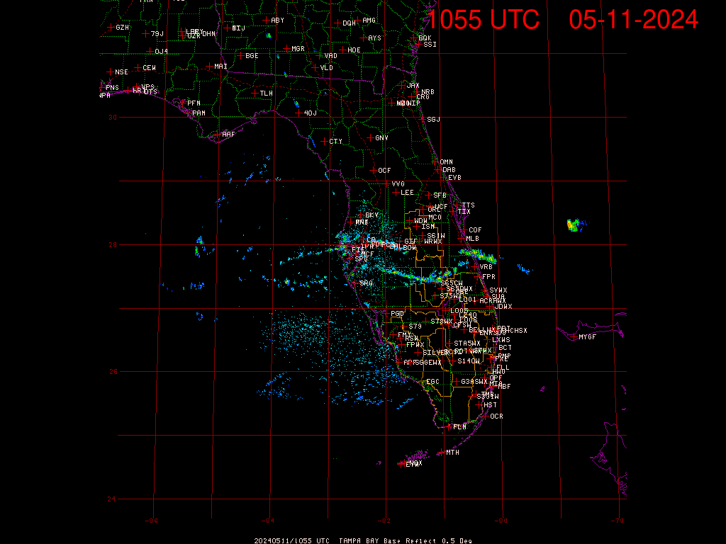
skysummit wrote:Bob Breck (LOL) just said he thinks the low nearest the mouth of the Mississippi River will win out, slowly organize and drift north toward the MGC.


Why the laughter?
0 likes   

User avatar
T-man
Tropical Storm
Tropical Storm
Posts: 240
Joined: Mon Jul 04, 2005 10:57 am
Location: Lafitte, LA

Re: Gulf Of Mexico Disturbance (RECON SET)

#342 Postby T-man » Wed Aug 01, 2007 9:58 pm

I think he might be right, if that's what he said. I don't watch BB much anymore. His credibility is shot in these parts, hence the laughter.
0 likes   

Kennethb
Category 2
Category 2
Posts: 506
Joined: Thu Aug 14, 2003 7:15 am
Location: Baton Rouge

#343 Postby Kennethb » Wed Aug 01, 2007 10:02 pm

I don't know why recon did not just fly out this evening. By the time they took off and got to cruising altitude, they would be near the low. They could fly out after supper and return in time to watch the early news.
0 likes   

User avatar
senorpepr
Military Met/Moderator
Posts: 12542
Age: 43
Joined: Fri Aug 22, 2003 9:22 pm
Location: Mackenbach, Germany
Contact:

Re:

#344 Postby senorpepr » Wed Aug 01, 2007 10:08 pm

Kennethb wrote:I don't know why recon did not just fly out this evening. By the time they took off and got to cruising altitude, they would be near the low. They could fly out after supper and return in time to watch the early news.


If I remember correctly, the crew needs 24 hours before they can being a mission. They can't just go on a drop of a hat. Besides, two crews are already away from Biloxi (if I'm not mistaken).
0 likes   

Stormcenter
S2K Supporter
S2K Supporter
Posts: 6684
Joined: Wed Sep 03, 2003 11:27 am
Location: Houston, TX

Re: Gulf Of Mexico Disturbance (RECON SET)

#345 Postby Stormcenter » Wed Aug 01, 2007 10:08 pm

Maybe just maybe the beginnings of something south of Mobile Bay.

http://www.ssd.noaa.gov/goes/east/gmex/loop-vis.html
0 likes   

sevenleft
Category 1
Category 1
Posts: 315
Joined: Sat Aug 05, 2006 2:36 pm

Re:

#346 Postby sevenleft » Wed Aug 01, 2007 10:35 pm

Kennethb wrote:I don't know why recon did not just fly out this evening. By the time they took off and got to cruising altitude, they would be near the low. They could fly out after supper and return in time to watch the early news.
Probably because there is nothing out there worth investigating at the moment.
0 likes   

jaxfladude
Category 5
Category 5
Posts: 1249
Joined: Wed Aug 24, 2005 9:36 pm
Location: Jacksonville, Fla

Re: Gulf Of Mexico Disturbance (RECON SET)

#347 Postby jaxfladude » Wed Aug 01, 2007 10:43 pm

Is seems that the invests are not becoming much more than a mod TS at most.....
0 likes   

User avatar
Janie2006
Category 5
Category 5
Posts: 1329
Joined: Mon Sep 18, 2006 3:28 pm
Location: coastal Ms aka home of the hurricanes

Re: Gulf Of Mexico Disturbance (RECON SET)

#348 Postby Janie2006 » Wed Aug 01, 2007 10:45 pm

Strictly my opinion, of course, but here goes...

If anything significant does organize I think it will move into SE Louisiana or the Mississippi Gulf Coast. Due to the set-up of the situation, the most significant rainfall could fall on the eastern side of the low. Given the timeframe and proximity of the system to the coastline, I'd be quite surprised if it formed into a weak TS. A tropical depression certainly isn't out of the question. On the other hand, we need to be on our guard because I've seen systems organize very quickly in the northern Gulf. Not seeing that situation here, but....still. YMMV.

We do need the rain because we're still behind on our rainfall. We've gained quite a bit of ground, but we need more.
0 likes   

User avatar
skysummit
S2K Supporter
S2K Supporter
Posts: 5305
Age: 49
Joined: Tue Aug 31, 2004 11:09 pm
Location: Ponchatoula, LA
Contact:

Re: Gulf Of Mexico Disturbance (RECON SET)

#349 Postby skysummit » Wed Aug 01, 2007 11:54 pm

T-man wrote:I think he might be right, if that's what he said. I don't watch BB much anymore. His credibility is shot in these parts, hence the laughter.


Yes, that's what I meant. By the laughter, I wasn't laughing at his forecast for the Gulf, just the idea that Bob said it. Not many people listen to him with the confidence they had prior to Katrina.

For instance, concerning 99L, tonight on the 9pm local news, he said the LLC could be forming to the north under the new convection (ok, that's not that bad). Then he said it could turn north, re-curve out to sea, and never affect anyone. (That brings back memories)
0 likes   

User avatar
crazycajuncane
S2K Supporter
S2K Supporter
Posts: 1097
Joined: Sun Aug 15, 2004 2:51 pm
Location: Lafayette, Louisiana
Contact:

Re: Gulf Of Mexico Disturbance (RECON SET)

#350 Postby crazycajuncane » Thu Aug 02, 2007 4:40 am

Quote Rob Perillo KATC.com weather blog:

An interesting situation continues to develop over Louisiana. A trough of low pressure is festering across the region keeping showers and storms in the forecast. A weak elongated area of surface low pressure has developed south of the Mississippi Coast and just east of Louisiana. This feature may remain nearly stationary through early tomorrow but may begin to drift westward for tomorrow night and Friday. So we are keeping high rain chances in the forecast through the next few days. There is a slight chance that we may some development with this low if a true closed circulation develops and there is the chance that we could see a depression form. While I’m not expected a major event, there is a fairly good possibility that we could see very heavy rains through Saturday. The large scale computer models have had a hard time dealing with this feature, while our in house mesoscale model (that’s available on-line on our weather page) has been consistent with development and drift to the west but the model may have the system too far offshore. And if you look at our wind forecast maps it could get quite breezy Friday and Saturday. For now, we’ll say that there will be very healthy rain chances with the threat of 3-5” of rain through Friday into Saturday. But there is the possibility that a 5-10 inch rain event will unfold for someone anywhere from our part of the world to the Florida Panhandle…so as we say stay tuned for further updates. More stable weather should move back into the region for the latter part of the weekend or early next week. :

Well whether it becomes anything or not.... MORE RAIN! I think we've seen enough rain this summer. I'm actually more interested in this feature than 99L.
0 likes   

stormy70

Re: Gulf Of Mexico Disturbance (RECON SET)

#351 Postby stormy70 » Thu Aug 02, 2007 5:35 am

Over here in Mobile they are just watching and telling us to bring our umbrellas. Just something to keep an eye on.
0 likes   

User avatar
TampaFl
S2K Supporter
S2K Supporter
Posts: 1904
Age: 67
Joined: Thu Sep 04, 2003 11:23 am
Location: Tampa, FL

Re: Gulf Of Mexico Disturbance (RECON SET)

#352 Postby TampaFl » Thu Aug 02, 2007 6:23 am

Radar loop from NWS Tampa /SFWMD site shows what appears to be a mid level circulation near 28 N & 84 W. It appears to be drifting east. more heavy rain for the west Coast of Florida :D . Thoughts & comments welcomed.


Image
0 likes   

caneman

Re: Gulf Of Mexico Disturbance (RECON SET)

#353 Postby caneman » Thu Aug 02, 2007 6:51 am

yep, I saw that to. No pressure falls just yet. Anybody have rainfall rates for this area brroken down by city? I know RONjon had posted 3" officially yesterday. We've been getting pounded by rain for a couple of days now. Just goes to show you that you don't need a TD, Ts or Hurricane to cuase problems. Intersting in that 24-36 hours ago we had alot of lightning but none sense. IS it trying to develop tropically? Current weather sure seems that way.
0 likes   

User avatar
skysummit
S2K Supporter
S2K Supporter
Posts: 5305
Age: 49
Joined: Tue Aug 31, 2004 11:09 pm
Location: Ponchatoula, LA
Contact:

Re: Gulf Of Mexico Disturbance (RECON SET)

#354 Postby skysummit » Thu Aug 02, 2007 6:55 am

What are your local mets along the Florida Coast saying? Are they saying any type of movement? Local mets up here are saying possible slow development, then should drift north toward the MGC. I'm just curious to see if there are any other forecasts.
0 likes   

User avatar
tailgater
S2K Supporter
S2K Supporter
Posts: 3339
Joined: Sun Jul 11, 2004 9:13 pm
Location: St. Amant La.

Re: Gulf Of Mexico Disturbance (RECON SET)

#355 Postby tailgater » Thu Aug 02, 2007 6:58 am

Yes very wet morning for Fla west coast with that mid level pushing ENE. I love that radar site. Low south of MSGC maybe trying to close off today.
http://www.intellicast.com/National/Rad ... imate=true
Question, TampaFL how do you post those animated loops?
0 likes   

User avatar
skysummit
S2K Supporter
S2K Supporter
Posts: 5305
Age: 49
Joined: Tue Aug 31, 2004 11:09 pm
Location: Ponchatoula, LA
Contact:

Re: Gulf Of Mexico Disturbance (RECON SET)

#356 Postby skysummit » Thu Aug 02, 2007 6:59 am

Have you ever seen such a straight frontal boundary/trough? LOL That's straight!

Image
0 likes   

caneman

Re: Gulf Of Mexico Disturbance (RECON SET)

#357 Postby caneman » Thu Aug 02, 2007 7:01 am

Sky,

I don't much follow TV weather. It's hard to when we seem to get and know stuff before they do.
0 likes   

User avatar
skysummit
S2K Supporter
S2K Supporter
Posts: 5305
Age: 49
Joined: Tue Aug 31, 2004 11:09 pm
Location: Ponchatoula, LA
Contact:

Re: Gulf Of Mexico Disturbance (RECON SET)

#358 Postby skysummit » Thu Aug 02, 2007 7:03 am

caneman wrote:Sky,

I don't much follow TV weather. It's hard to when we seem to get and know some before they do.


I hear ya, and agree. I barely ever watch them...mostly for entertainment purposes. I was just wondering if there any conflicting forecasts along the Gulf Coast. (like there wouldn't be :) )
0 likes   

User avatar
dizzyfish
S2K Supporter
S2K Supporter
Posts: 1519
Joined: Fri Sep 16, 2005 7:56 am
Location: New Port Richey, FL

Re: Gulf Of Mexico Disturbance (RECON SET)

#359 Postby dizzyfish » Thu Aug 02, 2007 7:05 am

Met in Tampa this morning was trying to show a spin on the radar loop he was showing. I personally couldn't see the spin. Anyway, about 1-1/2" here at home so far.
I think he said the blob would shift north.
0 likes   

flwxwatcher
Category 4
Category 4
Posts: 926
Joined: Wed May 16, 2007 3:35 pm
Location: Central Florida

Re: Gulf Of Mexico Disturbance (RECON SET)

#360 Postby flwxwatcher » Thu Aug 02, 2007 7:35 am

On the Tampa Long range Radar it looked like a spin right around 28 N and 85 W.
0 likes   


Return to “Talkin' Tropics”

Who is online

Users browsing this forum: redingtonbeach and 39 guests