Invest 99L Thread #6
Moderator: S2k Moderators
Forum rules

The posts in this forum are NOT official forecasts and should not be used as such. They are just the opinion of the poster and may or may not be backed by sound meteorological data. They are NOT endorsed by any professional institution or STORM2K. For official information, please refer to products from the National Hurricane Center and National Weather Service.
Re: Invest 99L Thread #6
It will lose it if it doesn't refire soon. Right now it still appears to have a convection-less core.
0 likes
-
cheezyWXguy

- Category 5

- Posts: 6282
- Joined: Mon Feb 13, 2006 12:29 am
- Location: Dallas, TX
Re: Invest 99L Thread #6
dont give it up yet...as of the last frame, a small dot of the 1st orange in a couple hours has formed west of the suspect center
0 likes
-
philnyc
- S2K Supporter

- Posts: 313
- Joined: Thu Jun 07, 2007 1:14 am
- Location: Brooklyn, New York City, New York
- Contact:
Re: Invest 99L Thread #6
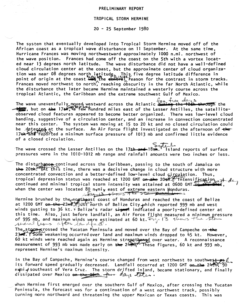
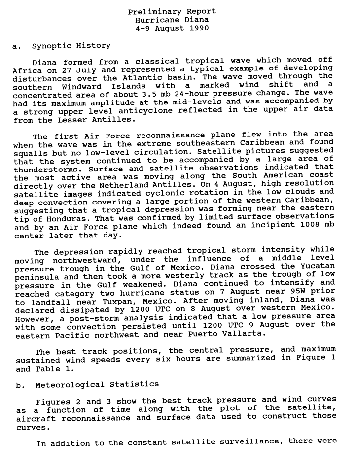
clfenwi wrote:There have certainly been cases of a wave making an inauspicious trot across the eastern Carribean before forming in the 80-85 W area. The second paragraphs of the reports on Hermine (1980) and Diane (1990) are vaguely familiar to the situation of the past three days (see also Dolly (1996)).
The system does have a bit of a TCHP maximum (TCHP chart) to run over as it makes its approach to that area, and it should be starting to (slightly) slow down in that vicinity. With just those two items for consideration, it would have an outside shot of developing on Saturday.
The big bit of uncertainty on whether it gets that shot is the upper-level shear situation. 20-30 knots in the area between 70-80W would seem to throw the chances of development to near zero. If it somehow manages to keep something together over the next 30-36 hours, then maybe just maybe it will finally develop, but that seems like a pretty large if at this time.
Nice analysis.
0 likes

-
AnnularCane

- S2K Supporter
- Posts: 2962
- Joined: Thu Jun 08, 2006 9:18 am
- Location: Wytheville, VA
Re: Invest 99L Thread #6
Sanibel wrote:Coin toss. I don't ever remember seeing any system return to form from such an evaporated wave. This one seriously poofed and dried out after today's deep red bursts. I'm watching this one because if it refires it will be a first. Safe bet says no, but I won't write it off until tomorrow.
I remember back in 2004, TD2 was downgraded to a wave, at one point appeared to have completely fizzled out, and then came back and became Bonnie. Of course this one never was a TD before (as far as I know). I don't know if that would make a difference or not.
I'm still not ready to give up on it.
0 likes
-
wxman57

- Moderator-Pro Met

- Posts: 23175
- Age: 68
- Joined: Sat Jun 21, 2003 8:06 pm
- Location: Houston, TX (southwest)
Re: Invest 99L Thread #6
A clue near the Yucatan. Note the convection firing in the western Caribbean now. That's the "stealth wave" that was preceding 99L across the Caribbean. It had NO convection the entire track across the Caribbean but now it's slowing down near the Yucatan and convection is firing up. 99L has a lot more energy than that wave, so watch out when it slows down in the western Caribbean.
0 likes
-
Ed Mahmoud
Re: Invest 99L Thread #6
cheezyWXguy wrote:dont give it up yet...as of the last frame, a small dot of the 1st orange in a couple hours has formed west of the suspect center
You're right. There are a couple of pixels of -50º near 14ºN and 71ºW!
Now I need to stay awake another half hour to see if it blossoms. Or maybe I won't.
0 likes
-
srainhoutx

- S2K Supporter
- Posts: 6919
- Age: 68
- Joined: Sun Jan 14, 2007 11:34 am
- Location: Haywood County, NC
- Contact:
Re: Invest 99L Thread #6
wxman57 wrote:A clue near the Yucatan. Note the convection firing in the western Caribbean now. That's the "stealth wave" that was preceding 99L across the Caribbean. It had NO convection the entire track across the Caribbean but now it's slowing down near the Yucatan and convection is firing up. 99L has a lot more energy than that wave, so watch out when it slows down in the western Caribbean.
Exactly what I have thought for 2 days now wxman57. That feature near the Yucatan has been a good indicator for 99L.
0 likes

Re: Invest 99L Thread #6
wxman57 wrote:A clue near the Yucatan. Note the convection firing in the western Caribbean now. That's the "stealth wave" that was preceding 99L across the Caribbean. It had NO convection the entire track across the Caribbean but now it's slowing down near the Yucatan and convection is firing up. 99L has a lot more energy than that wave, so watch out when it slows down in the western Caribbean.
If I recall, Hurricane Rita of 2005 came from a "stealth wave" that was set off by a frontal boundary.
0 likes


Re: Invest 99L Thread #6
It's worth noting that the majority of model tracks (including the statistical ones, the BAM models, etc.) now take it into the Bay of Campeche--11 tracks I counted. So far none of them take it towards the Texas coastline, but with every model run, they move more north, so that 6-8 of them are now at about Tampico or north of it. Several of them are stalling it/drifting westward there now, including the WRF and GFDL. About the same number (10-11) take it into Nicaragua/Honduras, but that number is dropping with every model run. Based on what I read this afternoon from the Texas AFDs, the global models are also now trending towards a weaker high pressure over the south central states at the time this thing enters the Gulf. People on the Texas and Louisiana coasts I think should really be paying attention to this in a couple days in case the high in the western Gulf does break down.
You can look at the models yourself by clicking on this link: http://hurricane.methaz.org/tracking/
Then click on the button "Click here to start interactive mapping", then uncheck the other boxes and check the box "all models". Then pan to the left.
You can look at the models yourself by clicking on this link: http://hurricane.methaz.org/tracking/
Then click on the button "Click here to start interactive mapping", then uncheck the other boxes and check the box "all models". Then pan to the left.
0 likes

-
srainhoutx
- S2K Supporter
- Posts: 6919
- Age: 68
- Joined: Sun Jan 14, 2007 11:34 am
- Location: Haywood County, NC
- Contact:
Re: Invest 99L Thread #6
Ptarmigan wrote:wxman57 wrote:A clue near the Yucatan. Note the convection firing in the western Caribbean now. That's the "stealth wave" that was preceding 99L across the Caribbean. It had NO convection the entire track across the Caribbean but now it's slowing down near the Yucatan and convection is firing up. 99L has a lot more energy than that wave, so watch out when it slows down in the western Caribbean.
If I recall, Hurricane Rita of 2005 came from a "stealth wave" that was set off by a frontal boundary.
Rita was further N than 99L. Passed S of Lower Keys in the FL Starights.
0 likes
-
hurricanefloyd5

- Category 5
- Posts: 1659
- Age: 45
- Joined: Sun May 02, 2004 10:53 am
- Location: Spartanburg
- Contact:
Re: Invest 99L Thread #6
Ithink the convection is firing near the center again i think???????? 

0 likes
-
hurricanefloyd5
- Category 5
- Posts: 1659
- Age: 45
- Joined: Sun May 02, 2004 10:53 am
- Location: Spartanburg
- Contact:
-
cheezyWXguy
- Category 5
- Posts: 6282
- Joined: Mon Feb 13, 2006 12:29 am
- Location: Dallas, TX
Re: Invest 99L Thread #6
hurricanefloyd5 wrote:Ithink the convection is firing near the center again i think????????
are you from the department of redundancy department? lol
0 likes
-
HouTXmetro

- Category 5
- Posts: 3949
- Joined: Sun Jun 13, 2004 6:00 pm
- Location: District of Columbia, USA
Re: Invest 99L Thread #6
The "structure" looks good to me even though there is minimum convection. Anyone care to elaborate?
0 likes
-
philnyc
- S2K Supporter
- Posts: 313
- Joined: Thu Jun 07, 2007 1:14 am
- Location: Brooklyn, New York City, New York
- Contact:
Re: Invest 99L Thread #6
wxman57 wrote:A clue near the Yucatan. Note the convection firing in the western Caribbean now. That's the "stealth wave" that was preceding 99L across the Caribbean. It had NO convection the entire track across the Caribbean but now it's slowing down near the Yucatan and convection is firing up. 99L has a lot more energy than that wave, so watch out when it slows down in the western Caribbean.
I noticed that too wxman57. Thanks for putting up good posts, consistently.
0 likes

Re: Invest 99L Thread #6
Yes, RL3AHO, I think that is definately an eye developing, this storm is probably at least a Cat 3 or 4 by now!
LOL, sarcasm is good at times like this, but if this does spin back up near the Yucatan, please don't joke, cause then it's going to destroy some lives in some way or another. I think some of us aren't necessarily wishers for big storms, but we do like to think of the worst case scenario in order to keep ourselves interested and on our toes. This storm still has potential and obviously warrants watching. None of us know for sure...
LOL, sarcasm is good at times like this, but if this does spin back up near the Yucatan, please don't joke, cause then it's going to destroy some lives in some way or another. I think some of us aren't necessarily wishers for big storms, but we do like to think of the worst case scenario in order to keep ourselves interested and on our toes. This storm still has potential and obviously warrants watching. None of us know for sure...
Last edited by mgpetre on Fri Aug 03, 2007 1:57 am, edited 1 time in total.
0 likes

Evening Thoughts,
Couple of things I wanted you guys to consider when discussing further development of this system. Shear (while talking about it is appropriate) is not a "death-bell" for future developent of this system. Many, many, and I mean many a system as developed under high shear. Of course shear might keep it from rapidly deepening, but from slowly developing? Nah. Remember, we are talking about a tropical wave, not a major hurricane. Its not like shear is going to weaken this thing anymore than it already is.
Next thing I wanted to mention is its forward speed....I don't know if you guys see the same thing as me, but I think it is slowing down a *bit*...its still flying westward but I feel that yesterday at this time it was just racing westward (as evidenced by the convection acting as if it were a derecho moreso than a tropical wave). It appears as if its not moving as fast as it was last night.
I think, before we proclaim this wave dead, is realize that it did have a big day today (and even I need to realize this before degrading this wave to nothing). It had a huge convective burst, formed a nice MLC, and has a very impressive outflow pattern. Now, if it develops a deep burst again tonight, it could get a low level circulation tomorrow.
0 likes
Who is online
Users browsing this forum: Iceresistance, Kingarabian and 342 guests