
Impressive looking system, and it has persisted. I do think this becomes a depression within a day and quite possibly Dean within a day or two.
-Andrew92
Invest 90L:East Atlantic,Discussions,Analysis and Sat Pics
Moderator: S2k Moderators
Forum rules

The posts in this forum are NOT official forecasts and should not be used as such. They are just the opinion of the poster and may or may not be backed by sound meteorological data. They are NOT endorsed by any professional institution or STORM2K. For official information, please refer to products from the National Hurricane Center and National Weather Service.
-
Matt-hurricanewatcher
Re: Invest 90L:East Atlantic Discussions,Analysis and Sat Pics
I don't understand why there is no SSD t numbers. That is very weird....I say 2.0t now. Earlier this morning quickscats shown 30 knot winds on the west side. Yes eastly shear has kepted it from organizing fast all last night...But I think with the blow up finally blowing up is a sign that it is out running the eastly shear. So soild organizion appears to be going on.
0 likes
Re: Invest 90L:East Atlantic Discussions,Analysis and Sat Pics
Tuesday night this will really be entering our radar.
0 likes

Re: Invest 90L:East Atlantic Discussions,Analysis and Sat Pics
Beautiful imagery on the sat pics  Gotta be a TD right now
0 likes
-
MiamiensisWx
Re: Invest 90L:East Atlantic Discussions,Analysis and Sat Pics
I created a layered image - I utilized the latest shortwave frame and I placed the recent QuikSCAT pass in the approximate location of the LLC (relative to the main convective mass).
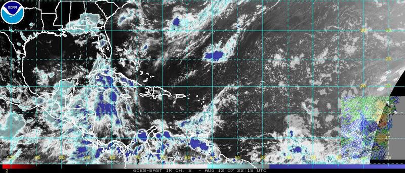
It looks like organization is sufficient for a TD classification.
It looks like organization is sufficient for a TD classification.
0 likes
-
miamicanes177
- Category 5

- Posts: 1131
- Joined: Tue Aug 01, 2006 10:53 pm
Re: Invest 90L:East Atlantic Discussions,Analysis and Sat Pics
I agree with the above posts and believe it's a tropical depression as we speak. NHC will upgrade it tonight most likely because they admitted in their TWO that only very slight increase in organization would make it an official TD.
And they might be delaying this as a TD because it would force them to issue a 5 day forecast path. Given the 12Z Euro, I would not want to issue a track forecast with intensity either.
And they might be delaying this as a TD because it would force them to issue a 5 day forecast path. Given the 12Z Euro, I would not want to issue a track forecast with intensity either.
Last edited by miamicanes177 on Sun Aug 12, 2007 6:25 pm, edited 1 time in total.
0 likes
-
canetracker

- S2K Supporter

- Posts: 751
- Age: 63
- Joined: Wed Jul 27, 2005 8:49 pm
- Location: Suburbia New Orleans...Harahan, LA
Re: Invest 90L:East Atlantic Discussions,Analysis and Sat Pics
Intensity guidance goes anywhere from a strong TS to Strong Cat 1 in 120 hrs:
http://euler.atmos.colostate.edu/~vigh/guidance/northatlantic/intensity_early1.png
http://euler.atmos.colostate.edu/~vigh/guidance/northatlantic/intensity_early1.png
0 likes
-
Extremeweatherguy

- Category 5
- Posts: 11095
- Joined: Mon Oct 10, 2005 8:13 pm
- Location: Florida
Re: Invest 90L:East Atlantic Discussions,Analysis and Sat Pics
Intensity would be a hard one, but 5-day path would not. There is a tight model consensus showing this moving toward the Caribbean, so a 5-day track similar to the current CONU (consensus model) track is what I would bet for if they upgraded this at 11pm...miamicanes177 wrote:I agree with the above posts and believe it's a tropical depression as we speak. NHC will upgrade it tonight most likely because they admitted in their TWO that only very slight increase in organization would make it an official TD.
And they might be delaying this as a TD because it would force them to issue a 5 day forecast path. Given the 12Z Euro, I would not want to issue a track forecast with intensity either.
http://www.sfwmd.gov/org/omd/ops/weathe ... orm_90.gif
0 likes
-
wzrgirl1

- S2K Supporter
- Posts: 1360
- Joined: Sat Sep 04, 2004 6:44 am
- Location: Pembroke Pines, Florida
Re: Invest 90L:East Atlantic Discussions,Analysis and Sat Pics
Extremeweatherguy wrote:Intensity would be a hard one, but 5-day path would not. There is a tight model consensus showing this moving toward the Caribbean, so a 5-day track similar to the current CONU (consensus model) track is what I would bet for if they upgraded this at 11pm...miamicanes177 wrote:I agree with the above posts and believe it's a tropical depression as we speak. NHC will upgrade it tonight most likely because they admitted in their TWO that only very slight increase in organization would make it an official TD.
And they might be delaying this as a TD because it would force them to issue a 5 day forecast path. Given the 12Z Euro, I would not want to issue a track forecast with intensity either.
http://www.sfwmd.gov/org/omd/ops/weathe ... orm_90.gif
I have always had a problem getting these plots to work. Everytime I click on it it brings up other plots although it says storm 90. Anyone give me tips on how to get the current runs to come up. Thanks.
0 likes
-
Derek Ortt
-
canetracker
- S2K Supporter
- Posts: 751
- Age: 63
- Joined: Wed Jul 27, 2005 8:49 pm
- Location: Suburbia New Orleans...Harahan, LA
Re: Invest 90L:East Atlantic Discussions,Analysis and Sat Pics
If the NHC has the slightest inclanation that this is a TD, they can't wait too long to issue a cone as it is only about 5 days away from the islands.
0 likes
-
Brent
- S2K Supporter
- Posts: 38729
- Age: 37
- Joined: Sun May 16, 2004 10:30 pm
- Location: Tulsa Oklahoma
- Contact:
Re: Invest 90L:East Atlantic Discussions,Analysis and Sat Pics
Extremeweatherguy wrote:Intensity would be a hard one, but 5-day path would not. There is a tight model consensus showing this moving toward the Caribbean, so a 5-day track similar to the current CONU (consensus model) track is what I would bet for if they upgraded this at 11pm...miamicanes177 wrote:I agree with the above posts and believe it's a tropical depression as we speak. NHC will upgrade it tonight most likely because they admitted in their TWO that only very slight increase in organization would make it an official TD.
And they might be delaying this as a TD because it would force them to issue a 5 day forecast path. Given the 12Z Euro, I would not want to issue a track forecast with intensity either.
http://www.sfwmd.gov/org/omd/ops/weathe ... orm_90.gif
Intensity on the first forecast is always tricky. I suspect they'll be following SHIPS pretty closely since it seems to be in the middle.
and also, this is only 4 days from the islands...
If they don't upgrade at 11 tonight, most likely they'll have to wait til 11am and I'm not sure they will do that.
Last edited by Brent on Sun Aug 12, 2007 6:40 pm, edited 1 time in total.
0 likes
-
Derek Ortt
-
wzrgirl1
- S2K Supporter
- Posts: 1360
- Joined: Sat Sep 04, 2004 6:44 am
- Location: Pembroke Pines, Florida
Re: Invest 90L:East Atlantic Discussions,Analysis and Sat Pics
That's a good point canetraker. I still think tomorrow morning because it will still be in the 5 day cone at the speed it's going. Will still give them plenty of time to prepare......although they should have some sort of preparations in order anyway.
0 likes
-
Weatherfreak14

- Category 5
- Posts: 1381
- Joined: Sat Sep 24, 2005 3:40 pm
- Location: Beaufort, SC
- Contact:
Re: Invest 90L:East Atlantic Discussions,Analysis and Sat Pics
I personally a little skepticial on how strong the Gfs model is making the ridge aginst a possible CAT 1-3 hurricane possible, and i personally not buying the carribean track into the GOM just yet.. Because GFS model has shown a strong ridge building for the past month but it manages to break down very quickly and build back quickly. Plus with a possible STRONG Hurricane possible, i am see a little mor Northerly track maybe towards Purto rico or just south of Pureto rico. But this is long term predition, right now, given it is possibly a T,D, it will maintain a Westward track until it gains a Strong TS status then it might take a slighter turn toward the WNW. over the next 3 days.
0 likes
-
canetracker
- S2K Supporter
- Posts: 751
- Age: 63
- Joined: Wed Jul 27, 2005 8:49 pm
- Location: Suburbia New Orleans...Harahan, LA
Re: Invest 90L:East Atlantic Discussions,Analysis and Sat Pics
wzrgirl1 wrote:That's a good point canetraker. I still think tomorrow morning because it will still be in the 5 day cone at the speed it's going. Will still give them plenty of time to prepare......although they should have some sort of preparations in order anyway.
That is true and as Derek posted, they should be listening to their local emergency management officials.
0 likes
-
Matt-hurricanewatcher
Re: Invest 90L:East Atlantic Discussions,Analysis and Sat Pics
Yeah convection looks a little linear but I care more about the organizion of the LLC. Quickscat shows a soild LLC with 30 knot winds...Also a buoy to its south shown a north,northwest,west, wind as the system passed to its north. Confirming the quickscat. Barry did not have organized convection or about 30 percent of the systems out of every system.
0 likes
-
wxman57

- Moderator-Pro Met

- Posts: 23172
- Age: 68
- Joined: Sat Jun 21, 2003 8:06 pm
- Location: Houston, TX (southwest)
Re:
Cyclone1 wrote:10 bucks for 11pm!
$1000 bucks nothing until visible shots tomorrow. We on?
0 likes
-
wxman57
- Moderator-Pro Met
- Posts: 23172
- Age: 68
- Joined: Sat Jun 21, 2003 8:06 pm
- Location: Houston, TX (southwest)
Re: Invest 90L:East Atlantic Discussions,Analysis and Sat Pics
wzrgirl1 wrote:
I have always had a problem getting these plots to work. Every time I click on it it brings up other plots although it says storm 90. Anyone give me tips on how to get the current runs to come up. Thanks.
What browser? Version? I suspect it's your web browser. PM me.
0 likes
Who is online
Users browsing this forum: Google Adsense [Bot] and 120 guests