Invest 90L:East Atlantic,Discussions,Analysis and Sat Pics

This is the general tropical discussion area. Anyone can take their shot at predicting a storms path.

Moderator: S2k Moderators

Forum rules

The posts in this forum are NOT official forecasts and should not be used as such. They are just the opinion of the poster and may or may not be backed by sound meteorological data. They are NOT endorsed by any professional institution or STORM2K. For official information, please refer to products from the National Hurricane Center and National Weather Service.

Help Support Storm2K
Message
Author
User avatar
wxman57
Moderator-Pro Met
Moderator-Pro Met
Posts: 22978
Age: 67
Joined: Sat Jun 21, 2003 8:06 pm
Location: Houston, TX (southwest)

Re:

#261 Postby wxman57 » Sun Aug 12, 2007 6:53 pm

RL3AO wrote:Considering convection still would have all night to build, I think it would be a storm at 5am.


No visible imagery by then. NHC will wait for visible loops. No earlier than 10am CDT. But then, I only have to predict hurricanes in my job. It's harder predicting what the NHC will do. :?:
0 likes   

Derek Ortt

#262 Postby Derek Ortt » Sun Aug 12, 2007 6:55 pm

I also believe the center is exposed.

The center would have had to move 3 degrees in the past 6 hours... for a forward speed of 30 mph to be under the convection. It's not quite moving that fast
0 likes   

clfenwi
Category 5
Category 5
Posts: 3331
Joined: Thu Jun 09, 2005 12:54 pm

Re: Invest 90L:East Atlantic Discussions,Analysis and Sat Pics

#263 Postby clfenwi » Sun Aug 12, 2007 6:55 pm

TROPICAL WEATHER DISCUSSION
NWS TPC/NATIONAL HURRICANE CENTER MIAMI FL
805 PM EDT SUN AUG 12 2007

...SPECIAL FEATURE...

A 1008 MB LOW...ASSOCIATED WITH A VIGOROUS TROPICAL WAVE ALONG
25W S OF 18N...IS LOCATED OVER THE CAPE VERDE ISLANDS NEAR
12.5N25W. SATELLITE IMAGERY SHOWS THE LOW-LEVEL CIRCULATION
PARTIALLY EXPOSED TO THE NE OF A CONVECTIVE MASS. THIS SYSTEM
HAS IMPROVED IN ORGANIZATION OVER THE PAST 24 HOURS AND A
TROPICAL DEPRESSION COULD FORM LATER TONIGHT OR TOMORROW AS THE
LOW MOVES WESTWARD AT 15-20 KT. PRESENTLY...SCATTERED MODERATE
TO ISOLATED STRONG CONVECTION IS FROM 6N-14N BETWEEN 27W-30W.
0 likes   

User avatar
wxman57
Moderator-Pro Met
Moderator-Pro Met
Posts: 22978
Age: 67
Joined: Sat Jun 21, 2003 8:06 pm
Location: Houston, TX (southwest)

Re: Invest 90L:East Atlantic 5:30 PM TWO Shortly

#264 Postby wxman57 » Sun Aug 12, 2007 6:57 pm

Blown_away wrote:
Ed Mahmoud wrote:Watching GOES imagery, just as sun set on visible imagery, new burst cold top convection on North side of 90L


That's what I'm seeing. I think people are looking at the E Atlantic satellite shot which is 3+ hours old. It's building convection and the LLC is near 12N /27W.


12N/27W is about right for the center. But that convection is at 12N/29W - 120 miles away. I have it on 30-minute imagery now with 1-deg lat/lon lines.
Last edited by wxman57 on Sun Aug 12, 2007 6:57 pm, edited 1 time in total.
0 likes   

RL3AO
Moderator-Pro Met
Moderator-Pro Met
Posts: 16308
Joined: Thu Jun 14, 2007 10:03 pm
Location: NC

Re: Invest 90L:East Atlantic Discussions,Analysis and Sat Pics

#265 Postby RL3AO » Sun Aug 12, 2007 6:57 pm

Image
0 likes   

User avatar
Recurve
Category 5
Category 5
Posts: 1640
Joined: Tue Aug 16, 2005 8:59 pm
Location: St. Petersburg, FL

Re: Invest 90L:East Atlantic Discussions,Analysis and Sat Pics

#266 Postby Recurve » Sun Aug 12, 2007 6:58 pm

Low about 3630 miles from Keys & Miami, arrives 7 a.m. Monday, Aug. 20
on direct track at 20 mph.

Not saying that's likely either for track or speed, just an estimate for planning purposes.

To the farthest east Lesser Antilles, 2330 miles -- 116.5 hrs @ 20 mph -- Friday, 2 p.m.
0 likes   

User avatar
wxman57
Moderator-Pro Met
Moderator-Pro Met
Posts: 22978
Age: 67
Joined: Sat Jun 21, 2003 8:06 pm
Location: Houston, TX (southwest)

Re: Invest 90L:East Atlantic Discussions,Analysis and Sat Pics

#267 Postby wxman57 » Sun Aug 12, 2007 7:00 pm

clfenwi wrote:TROPICAL WEATHER DISCUSSION
NWS TPC/NATIONAL HURRICANE CENTER MIAMI FL
805 PM EDT SUN AUG 12 2007

...SPECIAL FEATURE...

A 1008 MB LOW...ASSOCIATED WITH A VIGOROUS TROPICAL WAVE ALONG
25W S OF 18N...IS LOCATED OVER THE CAPE VERDE ISLANDS NEAR
12.5N25W. SATELLITE IMAGERY SHOWS THE LOW-LEVEL CIRCULATION
PARTIALLY EXPOSED TO THE NE OF A CONVECTIVE MASS. THIS SYSTEM
HAS IMPROVED IN ORGANIZATION OVER THE PAST 24 HOURS AND A
TROPICAL DEPRESSION COULD FORM LATER TONIGHT OR TOMORROW AS THE
LOW MOVES WESTWARD AT 15-20 KT. PRESENTLY...SCATTERED MODERATE
TO ISOLATED STRONG CONVECTION IS FROM 6N-14N BETWEEN 27W-30W.


I'm really starting to wonder about who's writing these things. 12.5N/25W is where the center was around 12Z. If it's moving at the 19 kts I calculated, it's nowhere near 25W as of 00Z.
0 likes   

RL3AO
Moderator-Pro Met
Moderator-Pro Met
Posts: 16308
Joined: Thu Jun 14, 2007 10:03 pm
Location: NC

Re: Invest 90L:East Atlantic Discussions,Analysis and Sat Pics

#268 Postby RL3AO » Sun Aug 12, 2007 7:01 pm

wxman57 wrote:
I'm really starting to wonder about who's writing these things. 12.5N/25W is where the center was around 12Z. If it's moving at the 19 kts I calculated, it's nowhere near 25W as of 00Z.


Wow. You are right.
0 likes   

Derek Ortt

#269 Postby Derek Ortt » Sun Aug 12, 2007 7:01 pm

that is the 18Z position

Not sure why TAFB does that, but the 0Z TWD provides the 18Z positions
0 likes   

User avatar
canegrl04
Category 5
Category 5
Posts: 2486
Joined: Thu Aug 26, 2004 5:37 pm
Location: Texas

Re: Invest 90L:East Atlantic Discussions,Analysis and Sat Pics

#270 Postby canegrl04 » Sun Aug 12, 2007 7:01 pm

So they are even saying this could be TD 4 by 11pm.
0 likes   

User avatar
Downdraft
S2K Supporter
S2K Supporter
Posts: 906
Joined: Wed Oct 09, 2002 8:45 pm
Location: Sanford, Florida
Contact:

Re: Invest 90L:East Atlantic Discussions,Analysis and Sat Pics

#271 Postby Downdraft » Sun Aug 12, 2007 7:27 pm

Deep breath everyone. It's a big sandbox we can all play in it nicely.
0 likes   

TheShrimper
Category 2
Category 2
Posts: 516
Joined: Sun Aug 01, 2004 5:05 pm

#272 Postby TheShrimper » Sun Aug 12, 2007 7:27 pm

If it takes a week to get ready, then you shouldn't be living in a susceptable area in Florida. You know that, do you not? All you are accomplishing by statements such as "planning purposes", references from Key Largo, ect is causing alarm and hysteria for the many here that do not know which way a low pressure system spins. The key word for you Artist is "indeed". If you need 7-10 days to get ready, youd best take 70 west to 27 north and get a place in Lake Wales. We got plenty of time, why the hell are you taking a powder already?
0 likes   

User avatar
cycloneye
Admin
Admin
Posts: 145303
Age: 68
Joined: Thu Oct 10, 2002 10:54 am
Location: San Juan, Puerto Rico

Re: Invest 90L:East Atlantic Discussions,Analysis and Sat Pics

#273 Postby cycloneye » Sun Aug 12, 2007 7:32 pm

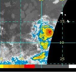
Image

A nice ball of convection.But the question is if the Low Pressure is beneath the clouds or still is exposed.
0 likes   

User avatar
hurricanefloyd5
Category 5
Category 5
Posts: 1659
Age: 44
Joined: Sun May 02, 2004 10:53 am
Location: Spartanburg
Contact:

Re: Invest 90L:East Atlantic Discussions,Analysis and Sat Pics

#274 Postby hurricanefloyd5 » Sun Aug 12, 2007 7:34 pm

0 likes   

Javlin
Category 5
Category 5
Posts: 1620
Age: 64
Joined: Fri Jul 09, 2004 7:58 pm
Location: ms gulf coast

Re: Invest 90L:East Atlantic Discussions,Analysis and Sat Pics

#275 Postby Javlin » Sun Aug 12, 2007 7:35 pm

I do not think so Luis if you look at the VIS you almost get that impression that the covection looks mushroomed and pushed to the the W image
Last edited by Javlin on Sun Aug 12, 2007 7:35 pm, edited 1 time in total.
0 likes   

User avatar
vacanechaser
Category 5
Category 5
Posts: 1461
Joined: Wed Dec 03, 2003 9:34 pm
Location: Portsmouth, Va
Contact:

Re:

#276 Postby vacanechaser » Sun Aug 12, 2007 7:35 pm

TheShrimper wrote:If it takes a week to get ready, then you shouldn't be living in a susceptable area in Florida. You know that, do you not? All you are accomplishing by statements such as "planning purposes", references from Key Largo, ect is causing alarm and hysteria for the many here that do not know which way a low pressure system spins. The key word for you Artist is "indeed". If you need 7-10 days to get ready, youd best take 70 west to 27 north and get a place in Lake Wales. We got plenty of time, why the hell are you taking a powder already?


i dont see anything wrong with what was said... nothing was said about boarding up, evacutions or anything of the sort... maybe the planing was in refrence to folks planning a trip or something... just a thought... you need to chill out and stop the flaming... i didnt see anything wrong with the post...


Jesse V. Bass III
http://www.vastormphoto.com
Hurricane Intercept Research Team
0 likes   

User avatar
hurricanefloyd5
Category 5
Category 5
Posts: 1659
Age: 44
Joined: Sun May 02, 2004 10:53 am
Location: Spartanburg
Contact:

Re: Invest 90L:East Atlantic Discussions,Analysis and Sat Pics

#277 Postby hurricanefloyd5 » Sun Aug 12, 2007 7:40 pm

we could very well see our first hurricane of the season!!!!!!!!
0 likes   

User avatar
Downdraft
S2K Supporter
S2K Supporter
Posts: 906
Joined: Wed Oct 09, 2002 8:45 pm
Location: Sanford, Florida
Contact:

Re: Invest 90L:East Atlantic Discussions,Analysis and Sat Pics

#278 Postby Downdraft » Sun Aug 12, 2007 7:41 pm

Heck I started planning the middle of May considering the season started June 1st. Guess I was really early. :lol:
0 likes   

User avatar
vacanechaser
Category 5
Category 5
Posts: 1461
Joined: Wed Dec 03, 2003 9:34 pm
Location: Portsmouth, Va
Contact:

Re: Invest 90L:East Atlantic Discussions,Analysis and Sat Pics

#279 Postby vacanechaser » Sun Aug 12, 2007 7:44 pm

Downdraft wrote:Heck I started planning the middle of May considering the season started June 1st. Guess I was really early. :lol:


lol.. good point... thats when they say to start!!!

i dont think we will see a td tonight... i think the nhc will wait till morning when they get a look at a visible shot... just my $.02


Jesse V. Bass III
http://www.vastormphoto.com
Hurricane Intercept Research Team
0 likes   

User avatar
dixiebreeze
S2K Supporter
S2K Supporter
Posts: 5140
Joined: Wed Sep 03, 2003 5:07 pm
Location: crystal river, fla.

Re: Invest 90L:East Atlantic Discussions,Analysis and Sat Pics

#280 Postby dixiebreeze » Sun Aug 12, 2007 7:46 pm

Now on Dvorak:

12/2345 UTC 12.6N 26.6W T1.0/1.5 90L -- Atlantic Ocean

Thinking there may be a TD issued at 10:30 p.m.
0 likes   


Return to “Talkin' Tropics”

Who is online

Users browsing this forum: Kingarabian, sasha_B, USTropics and 45 guests