If you look further to the north and east from where the low center is suppose to be it's almost like you see a new broad circulation forming. Hey just my observation.
http://www.ssd.noaa.gov/goes/east/gmex/loop-vis.html
INVEST 91L -Discussions,Analysis and Imagery
Moderator: S2k Moderators
-
Stormcenter
- S2K Supporter

- Posts: 6689
- Joined: Wed Sep 03, 2003 11:27 am
- Location: Houston, TX
Re: INVEST 91L: near W Carib/GOM
0 likes
-
joseintexas
- Tropical Wave

- Posts: 3
- Joined: Mon Aug 13, 2007 6:42 pm
Re: INVEST 91L: near W Carib/GOM
chadtm80 wrote:joseintexas wrote:Hello my friends i am still learning im only 32 but how early can this form?
You couldn't just take your suspension and deal with it.. This is your 4th account you have set up and used since your suspension... You will now be perminatley banned.
What are you talking about sir.This is my 1st account, I have no idea what you are talking about.
0 likes
-
HURAKAN

- Professional-Met

- Posts: 46084
- Age: 39
- Joined: Thu May 20, 2004 4:34 pm
- Location: Key West, FL
- Contact:
ATTENTION...NATIONAL HURRICANE CENTER
NCEP COUPLED GFDL HURRICANE MODEL FORECAST MADE FOR
TROPICAL DEPRESSION INVEST 91L
INITIAL TIME 18Z AUG 13
DISCLAIMER ... THIS INFORMATION IS PROVIDED AS GUIDANCE. IT
REQUIRES INTERPRETATION BY HURRICANE SPECIALISTS AND SHOULD
NOT BE CONSIDERED AS A FINAL PRODUCT. PLEASE SEE THE TPC/NHC
OFFICIAL FORECAST.
FORECAST STORM POSITION
HOUR LATITUDE LONGITUDE HEADING/SPEED(KT)
0 21.7 87.1 290./11.1
6 22.1 87.7 305./ 7.2
12 22.9 88.7 306./11.5
18 23.8 89.6 317./12.4
24 24.7 90.8 307./13.8
30 25.0 92.2 282./13.6
36 25.2 93.8 279./14.6
42 26.0 95.3 298./15.6
48 26.6 96.9 290./15.8
54 27.0 98.4 283./13.2
60 27.4 99.7 287./12.1
66 27.9 100.7 297./10.1
72 28.2 101.7 289./10.0
78 29.1 103.0 303./14.5
84 30.1 104.3 309./15.3
90 31.2 105.6 311./15.0
96 32.2 106.2 327./11.6
STORM DISSIPATED AT 96 HRS AT THE ABOVE PSN.
0 likes
-
Aric Dunn
- Category 5

- Posts: 21238
- Age: 43
- Joined: Sun Sep 19, 2004 9:58 pm
- Location: Ready for the Chase.
- Contact:
Re: INVEST 91L: near W Carib/GOM
Stormcenter wrote:If you look further to the north and east from where the low center is suppose to be it's almost like you see a new broad circulation forming. Hey just my observation.
http://www.ssd.noaa.gov/goes/east/gmex/loop-vis.html
looks more mid level ...but could possibly try to reform farther to the north
0 likes
-
Extremeweatherguy

- Category 5
- Posts: 11095
- Joined: Mon Oct 10, 2005 8:13 pm
- Location: Florida

-
AnnularCane

- S2K Supporter
- Posts: 2957
- Joined: Thu Jun 08, 2006 9:18 am
- Location: Wytheville, VA
Re: INVEST 91L: near W Carib/GOM
If it reformed farther north, would it have any significant affect on the forecast track?
0 likes
-
jasons2k

- Storm2k Executive

- Posts: 8290
- Age: 52
- Joined: Wed Jul 06, 2005 12:32 pm
- Location: The Woodlands, TX
Re: INVEST 91L: near W Carib/GOM
AnnularCane wrote:If it reformed farther north, would it have any significant affect on the forecast track?
Yes - see Cindy, Exhibit: A
EDIT: But don't look for this to go to LA, that was an entirely differnt scenario. But any reformation to the NE *could* mean a landfall further up the TX coast.
0 likes
-
Frank P
- S2K Supporter
- Posts: 2779
- Joined: Fri Aug 29, 2003 10:52 am
- Location: Biloxi Beach, Ms
- Contact:
Re: INVEST 91L: near W Carib/GOM
Looks more mid level to me too.. obviously stacking issues in the early stages of development, if it were to become the dominate circulation center and it could work its way down to the surface, then it would have an impact on where this thing would eventually go.. probably further up the TX coast but just speculating on my part... chances are the the LLC off the coast of the Yucatan will win out and the invest will continue to head off to the west to north west.. but ya never know, which makes these things so interesting to monitor
0 likes

Re: INVEST 91L: near W Carib/GOM
I would not be surprised to see another center form further N and E of the current LLC. We see this often with disorganized weak/developing tropical systems. Current satellite looks like its slowly coming together.
http://www.ssd.noaa.gov/goes/east/gmex/loop-vis.html
http://www.ssd.noaa.gov/goes/east/gmex/loop-vis.html
0 likes
Re: INVEST 91L: near W Carib/GOM
Ship with a nice fresh breeze
Code: Select all
ID      T1 TIME    LAT     LON DIST HDG WDIR  WSPD   GST  WVHT   DPD   APD MWD   PRES  PTDY
           (GMT)                 nm  °T   °T   kts   kts    ft   sec   sec  °T     in    in
--------------------------------------------------------------------------------------------
SHIP     S 0000  23.80  -87.70  182 307   80  29.9     -   9.8   4.0     -   -  29.77 -0.03
0 likes
-
srainhoutx

- S2K Supporter
- Posts: 6919
- Age: 68
- Joined: Sun Jan 14, 2007 11:34 am
- Location: Haywood County, NC
- Contact:
Re: INVEST 91L: near W Carib/GOM
KatDaddy wrote:I would not be surprised to see another center form further N and E of the current LLC. We see this often with disorganized weak/developing tropical systems. Current satellite looks like its slowly coming together.
http://www.ssd.noaa.gov/goes/east/gmex/loop-vis.html
Cancun radar view is interesting. Might be on to something to the NE...
http://smn.cna.gob.mx/radares/rad-canc.jpg
0 likes

Re: INVEST 91L: near W Carib/GOM
Anyone noticing that the ULL in the gulf is getting quite a bit more of a northward component in the last couple of Satellite frames? Looks like further up the TX coast is quite the possibility if this holds its trend. Any thoughts?
0 likes
-
wxman57

- Moderator-Pro Met

- Posts: 23172
- Age: 68
- Joined: Sat Jun 21, 2003 8:06 pm
- Location: Houston, TX (southwest)
Re: INVEST 91L: near W Carib/GOM
First of all, check the link on my hurricane links web page for the radar beam height calculator. Derek's position, for example, is 110nm NW of Cancun. (http://www.wdtb.noaa.gov/tools/misc/beamwidth/beamwidth.html). That puts the beam center at just under 15,000 ft above the surface. I think that the map below indicates the broad low may be a bit northwest of that point, but it's certainly no tight center so you can pick a number of spots out there as the "center". Lowest pressure in the area probably about 1006 mb, though there are no ships in the area of the lowest pressure:

0 likes
-
HouTXmetro

- Category 5
- Posts: 3949
- Joined: Sun Jun 13, 2004 6:00 pm
- Location: District of Columbia, USA
Re: INVEST 91L: near W Carib/GOM
Satellite presentation looks horrible tonight in terms of organization and convection.
0 likes
Re: INVEST 91L: near W Carib/GOM
Pretty much goes with what the Cancun radar shows. There is a small feederband-like area of heavy showers just NNW of the tip of the Yucatan
http://smn.cna.gob.mx/radares/rad-canc.jpg
http://smn.cna.gob.mx/radares/rad-canc.jpg
0 likes
-
srainhoutx
- S2K Supporter
- Posts: 6919
- Age: 68
- Joined: Sun Jan 14, 2007 11:34 am
- Location: Haywood County, NC
- Contact:
Re:
KatDaddy wrote:Thanks for the plot map Wxman57. Its definitely shows were the LLC is located. A very disorganized system currently.
Thanks wxman57.
0 likes
-
Extremeweatherguy
- Category 5
- Posts: 11095
- Joined: Mon Oct 10, 2005 8:13 pm
- Location: Florida
Re: INVEST 91L: near W Carib/GOM
Here is an image I just plotted showing the approx. location Derek thinks the LLC is at...
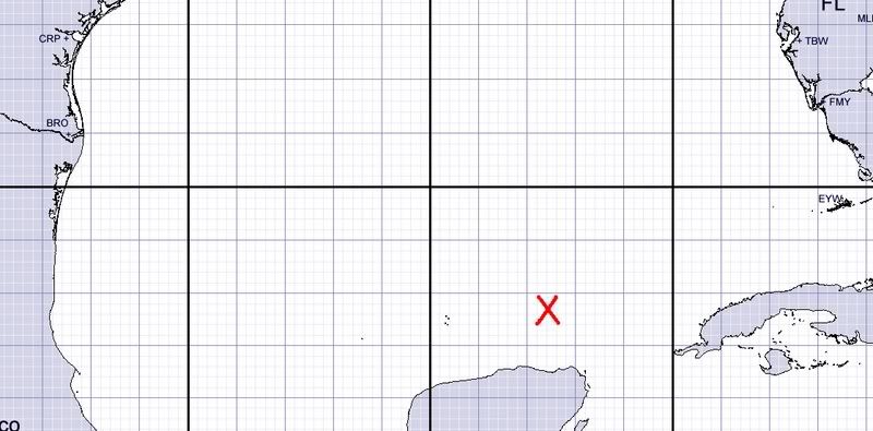
22.7N, 87.6W
This is a little further to the SE than what wxman's image shows above.
22.7N, 87.6W
This is a little further to the SE than what wxman's image shows above.
Last edited by Extremeweatherguy on Mon Aug 13, 2007 8:00 pm, edited 1 time in total.
0 likes
Who is online
Users browsing this forum: No registered users and 27 guests