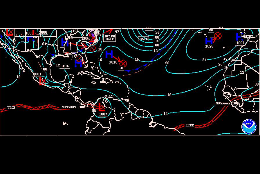
Tropical Wave Midway Between Africa and Lesser Antilles
Moderator: S2k Moderators
Forum rules
The posts in this forum are NOT official forecasts and should not be used as such. They are just the opinion of the poster and may or may not be backed by sound meteorological data. They are NOT endorsed by any professional institution or STORM2K. For official information, please refer to products from the National Hurricane Center and National Weather Service.
- HurricaneMaster_PR
- Category 2

- Posts: 795
- Joined: Tue Jul 22, 2003 6:23 pm
- Location: San Juan, Puerto Rico
Tropical Wave Midway Between Africa and Lesser Antilles
2:05pm Discussion
...TROPICAL WAVES...
A TROPICAL WAVE IS INTRODUCED OFF THE COAST OF WEST AFRICA ALONG
18W S OF 22N MOVING W AT 10-15 KT. THE WAVE IS BASED ON VISIBLE
SATELLITE IMAGERY...SURFACE OBSERVATIONS...DAKAR UPPER SOUNDING
...HOVMOLLER DIAGRAM...AND THE SSMI/AMSRE TOTAL PRECIPITABLE
WATER IMAGERY. AN AREA OF BROAD CYCLONIC TURNING IS NOTED.
CONVECTION IS CONFINED TO THE ITCZ WITH WIDELY SCATTERED
MODERATE CONVECTION FROM 7N-13N BETWEEN 14W-25W.
http://www.nhc.noaa.gov/tafb/ATSA_12Z.gif
0 likes
- HurricaneMaster_PR
- Category 2

- Posts: 795
- Joined: Tue Jul 22, 2003 6:23 pm
- Location: San Juan, Puerto Rico
Re: New Tropical Wave introduced off the coast of Africa
TROPICAL WEATHER DISCUSSION
NWS TPC/NATIONAL HURRICANE CENTER MIAMI FL
805 PM EDT TUE AUG 28 2007
...TROPICAL WAVES...
A TROPICAL WAVE IS ALONG 20W S OF 21N MOVING W AT 10-15 KT.
SATELLITE IMAGERY SHOWS A BROAD AREA OF CYCLONIC TURNING
ASSOCIATED WITH THIS WAVE IN THE VICINITY OF THE CAPE VERDE
ISLANDS. 850 MB MODEL GUIDANCE SUGGEST A STRONG VORTICITY
MAXIMUM IMPLYING A LOW WITHIN THIS AREA. WIDELY SCATTERED
MODERATE CONVECTION IS FROM 10N-16N EAST OF 22W. A QUIKSCAT PASS
FROM AROUND 2000 UTC ALSO SHOWED A CYCLONIC CIRCULATION NEAR
12N22W.
0 likes
- HurricaneMaster_PR
- Category 2

- Posts: 795
- Joined: Tue Jul 22, 2003 6:23 pm
- Location: San Juan, Puerto Rico
Re: New Tropical Wave introduced off the coast of Africa
Based on the latest TPC Surface Analysis chart the wave is now accompanied by a 1011mb low...


0 likes
- SouthFloridawx
- S2K Supporter

- Posts: 8346
- Age: 47
- Joined: Tue Jul 26, 2005 1:16 am
- Location: Sarasota, FL
- Contact:
- SouthFloridawx
- S2K Supporter

- Posts: 8346
- Age: 47
- Joined: Tue Jul 26, 2005 1:16 am
- Location: Sarasota, FL
- Contact:
Re: New Tropical Wave introduced off the coast of Africa
Looking a little closer to some sat. imagery, I think the wave behind this one, about to move off the coast tomorrow/tomorrow night... should probably help this one out.
I give it a 40% chance of becoming an invest in the next 2 days...
http://oiswww.eumetsat.org/SDDI/html/images/out/SDDI-20070829-0600-RGB-09-DUST-00-800.jpg
I give it a 40% chance of becoming an invest in the next 2 days...
http://oiswww.eumetsat.org/SDDI/html/images/out/SDDI-20070829-0600-RGB-09-DUST-00-800.jpg
0 likes
- gatorcane
- S2K Supporter

- Posts: 23708
- Age: 48
- Joined: Sun Mar 13, 2005 3:54 pm
- Location: Boca Raton, FL
Vigorous Wave at 12N 27W Behind 94L
All,
I'm very surpised we are not talking about this one. It's farther north in lattitude and convection is blowing up nicely this morning. There also seems to be a good spin. Since its farther north in lattitude than 94L it could have implications on the future track (if it holds together a it may track more W to WNW then W or WSW like 94L)

I'm very surpised we are not talking about this one. It's farther north in lattitude and convection is blowing up nicely this morning. There also seems to be a good spin. Since its farther north in lattitude than 94L it could have implications on the future track (if it holds together a it may track more W to WNW then W or WSW like 94L)

0 likes
- SWFLA_CANE
- Tropical Storm

- Posts: 196
- Joined: Tue Jun 06, 2006 6:41 pm
- Location: Naples, Florida
- gatorcane
- S2K Supporter

- Posts: 23708
- Age: 48
- Joined: Sun Mar 13, 2005 3:54 pm
- Location: Boca Raton, FL
Re: Vigorous Wave at 12N 27W Behind 94L
Yes, and its at a perfect lattitude for development, its almost September, lots of convection....I say its something to watch.
Maybe we can merge this thread with the other one that was started previously on this topic.....it wasn't obvious to me that there was a thread on this by the title of the topic.
Maybe we can merge this thread with the other one that was started previously on this topic.....it wasn't obvious to me that there was a thread on this by the title of the topic.
0 likes
- windstorm99
- S2K Supporter

- Posts: 1578
- Age: 48
- Joined: Sat May 26, 2007 8:10 am
- Location: Miami, Florida
- Contact:
Re: New Tropical Wave introduced off the coast of Africa
This is the wave to place close attention in the coming week or so as it already at a dangerous latitude and looks fairly well organized on morning visibles.


Last edited by windstorm99 on Wed Aug 29, 2007 9:02 am, edited 1 time in total.
0 likes
- windstorm99
- S2K Supporter

- Posts: 1578
- Age: 48
- Joined: Sat May 26, 2007 8:10 am
- Location: Miami, Florida
- Contact:
Re:
gatorcane wrote:thanks x-y-no.
This wave is the best looking one at that lattitude this hurricane season.
Let's see if it develops
Its at a dangerous latitude gator if you ask me.
0 likes
-
Derek Ortt
Re: New Tropical Wave introduced off the coast of Africa
I'd like to see a little more model support for this feature
Will check out at HRD in about 90 minutes whether or not there is any SAL for this system to contend with
Will check out at HRD in about 90 minutes whether or not there is any SAL for this system to contend with
0 likes
Who is online
Users browsing this forum: No registered users and 55 guests


