Invest 94L,Near Windwards-Discussions

Moderator: S2k Moderators

Message
Author
User avatar
Regit
Category 5
Category 5
Posts: 2341
Joined: Mon Sep 15, 2003 9:02 pm
Location: Myrtle Beach

Re: 94L,Discussions-Analysis & Imagery=5:30 PM TWO Shortly

#541 Postby Regit » Thu Aug 30, 2007 4:13 pm

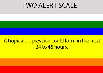
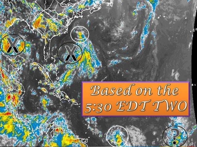
Blown_away wrote:Clip on 94L from Accuweather:
The third area of concern in the Atlantic is a tropical wave well east of the Lesser Antilles. This system was becoming better organized Thursday afternoon and was creating banded structure to thunderstorms in the area. Through the weekend, an area of high pressure will steer the wave toward the large islands of the Caribbean, which will further hinder the development of the system.

Do they mean PR & Hispanola? The Lesser Antilles shouldn't hinder development to much?


I would surely think they mean the Greater Antilles.
0 likes   

User avatar
HURAKAN
Professional-Met
Professional-Met
Posts: 46086
Age: 38
Joined: Thu May 20, 2004 4:34 pm
Location: Key West, FL
Contact:

#542 Postby HURAKAN » Thu Aug 30, 2007 4:18 pm

Image

Becoming much better organized during DMIN?!?!?! That's new. Maybe b/c it's almost September.

http://www1.cira.colostate.edu/ramm/rms ... PICAL.html

Click on the Goes-EAST left Floater and you will see a nice circulation.
0 likes   

User avatar
ConvergenceZone
Category 5
Category 5
Posts: 5194
Joined: Fri Jul 29, 2005 1:40 am
Location: Northern California

Re:

#543 Postby ConvergenceZone » Thu Aug 30, 2007 4:20 pm

KFDM Meteorologist wrote:Long Range Models show High building west as the system moves west north of the system keeping it on a similar track as Dean. We'll see how it all pans out.


It will probably most west similar to Dean until it gets far enough west, and then take a move north once it gets into the gulf. I can't see the high moving west exactly as it did with Dean. That would be too freaky....
0 likes   

User avatar
cycloneye
Admin
Admin
Posts: 145327
Age: 68
Joined: Thu Oct 10, 2002 10:54 am
Location: San Juan, Puerto Rico

Re: 94L,Discussions-Analysis & Imagery=5:30 PM TWO Shortly

#544 Postby cycloneye » Thu Aug 30, 2007 4:21 pm

The 5:30 PM TWO is delayed because they have to type many sentences about various disturbances.
0 likes   

User avatar
vbhoutex
Storm2k Executive
Storm2k Executive
Posts: 29112
Age: 73
Joined: Wed Oct 09, 2002 11:31 pm
Location: Cypress, TX
Contact:

Re: 94L,Discussions-Analysis & Imagery=5:30 PM TWO Shortly

#545 Postby vbhoutex » Thu Aug 30, 2007 4:22 pm

Untill it quits spitting out those outflow boundaries to the NE it isn't going to do too much, just like Derek said. It does look like it is doing its' best to get its' act together in a somewhat "hostile" environment though. Tomorrow could get interesting.

As far as the accuweather quote is concerned, it sounds like they must be talking about Hispaniola, PR, etc. but 94L is going to have to start moving poleward soon if this is to come about. ATM I do not see it happening.
0 likes   

User avatar
HURAKAN
Professional-Met
Professional-Met
Posts: 46086
Age: 38
Joined: Thu May 20, 2004 4:34 pm
Location: Key West, FL
Contact:

#546 Postby HURAKAN » Thu Aug 30, 2007 4:23 pm

Tropical Weather Outlook


Statement as of 5:30 PM EDT on August 30, 2007
For the North Atlantic...Caribbean Sea and the Gulf of Mexico...
Showers activity associated with a tropical wave located about 525
miles east of the Windward Islands has become a little better
organized this afternoon. Upper-level winds are expected to be
favorable for development...and this system has the potential to
become a tropical depression over the next day or two as it moves
generally westward about 15 mph. Interests in the Windward Islands
should monitor the progress of this system. An Air Force Reserve
hurricane hunter aircraft is scheduled to investigate the system on
Friday...if necessary.

Beven
0 likes   

Cyclone1
Category 5
Category 5
Posts: 2739
Age: 33
Joined: Tue Jun 12, 2007 12:03 pm
Location: Florida

#547 Postby Cyclone1 » Thu Aug 30, 2007 4:27 pm

So according to RL3AO's TWO "State of tropical cyclone formation awareness system" (or Sotrocyfas), we are under code orange I believe?

Yes, I made up that name on the spot.
Last edited by Cyclone1 on Thu Aug 30, 2007 4:30 pm, edited 1 time in total.
0 likes   

RL3AO
Moderator-Pro Met
Moderator-Pro Met
Posts: 16308
Joined: Thu Jun 14, 2007 10:03 pm
Location: NC

#548 Postby RL3AO » Thu Aug 30, 2007 4:28 pm

Yellow.

Image
0 likes   

Brent
S2K Supporter
S2K Supporter
Posts: 38090
Age: 36
Joined: Sun May 16, 2004 10:30 pm
Location: Tulsa Oklahoma
Contact:

Re: Invest 94L,Discussions=5:30 PM TWO Posted on page 28

#549 Postby Brent » Thu Aug 30, 2007 4:29 pm

Maybe this will develop and we can get another storm in August. 8-)
0 likes   

Cyclone1
Category 5
Category 5
Posts: 2739
Age: 33
Joined: Tue Jun 12, 2007 12:03 pm
Location: Florida

Re:

#550 Postby Cyclone1 » Thu Aug 30, 2007 4:33 pm

RL3AO wrote:Yellow.

Image


Ah, yellow. Hmm, looking at it again, Sotrocyfas is a sucky acronym...
0 likes   

CrazyC83
Professional-Met
Professional-Met
Posts: 34002
Joined: Tue Mar 07, 2006 11:57 pm
Location: Deep South, for the first time!

#551 Postby CrazyC83 » Thu Aug 30, 2007 4:34 pm

Of the three Invests right now, I'd say this one is farthest from being a TD.
0 likes   

User avatar
windstorm99
S2K Supporter
S2K Supporter
Posts: 1578
Age: 47
Joined: Sat May 26, 2007 8:10 am
Location: Miami, Florida
Contact:

Re: Invest 94L,Discussions=5:30 PM TWO Posted on page 28

#552 Postby windstorm99 » Thu Aug 30, 2007 4:35 pm

Even if this developes it does not look like a U.S. threat as of now.Adrian
0 likes   

Cyclone1
Category 5
Category 5
Posts: 2739
Age: 33
Joined: Tue Jun 12, 2007 12:03 pm
Location: Florida

Re:

#553 Postby Cyclone1 » Thu Aug 30, 2007 4:36 pm

CrazyC83 wrote:Of the three Invests right now, I'd say this one is farthest from being a TD.

I agree with you partly, 96L looks closest, but 97L is just a blob of clouds. This may be the only one to ever get classified, though.
0 likes   

CrazyC83
Professional-Met
Professional-Met
Posts: 34002
Joined: Tue Mar 07, 2006 11:57 pm
Location: Deep South, for the first time!

Re: Invest 94L,Discussions=5:30 PM TWO Posted on page 28

#554 Postby CrazyC83 » Thu Aug 30, 2007 4:37 pm

windstorm99 wrote:Even if this developes it does not look like a U.S. threat as of now.Adrian


I agree; 95L weakened too much to break the ridge and this will be too far west if it redevelops. I think it is going down the road Dean took...
0 likes   

User avatar
MetroMike
Category 4
Category 4
Posts: 952
Joined: Sun Aug 29, 2004 8:13 pm
Location: Tampa Bay
Contact:

Re: Invest 94L,Discussions=5:30 PM TWO Posted on page 28

#555 Postby MetroMike » Thu Aug 30, 2007 4:37 pm

Favorable for development today says the TPC for a few waves out there..If they dont, they can just turn it around tomorrow saying conditions appear unfavorable for development wihtout explanation given.
0 likes   

Matt-hurricanewatcher

Re:

#556 Postby Matt-hurricanewatcher » Thu Aug 30, 2007 4:44 pm

CrazyC83 wrote:Of the three Invests right now, I'd say this one is farthest from being a TD.


96L is the best because of the LLC and the convection forming right over it. But this does not look to bad overall.
0 likes   

User avatar
Buck
S2K Supporter
S2K Supporter
Posts: 1173
Joined: Fri Sep 10, 2004 12:04 pm
Location: Atlanta, GA

#557 Postby Buck » Thu Aug 30, 2007 4:46 pm

If, say, this and 96L both developed and went on to be named... I would hope this one is first because I'd love to see a storm named "Felix" have a more interesting track than the last three Felixes. Not to say that I don't like fish storm tracks... I do and I like that they cause no harm. It just seems that Felix is always the same storm every 6 years!
0 likes   

User avatar
windstorm99
S2K Supporter
S2K Supporter
Posts: 1578
Age: 47
Joined: Sat May 26, 2007 8:10 am
Location: Miami, Florida
Contact:

Re: Invest 94L,Discussions=5:30 PM TWO Posted on page 28

#558 Postby windstorm99 » Thu Aug 30, 2007 4:47 pm

Fun to watch but in all honesty none of these systems pose a significant threat to the united states as of now.

Visible loop of 94L....

Image
0 likes   

User avatar
HURAKAN
Professional-Met
Professional-Met
Posts: 46086
Age: 38
Joined: Thu May 20, 2004 4:34 pm
Location: Key West, FL
Contact:

#559 Postby HURAKAN » Thu Aug 30, 2007 4:55 pm

Image
0 likes   

Cyclone1
Category 5
Category 5
Posts: 2739
Age: 33
Joined: Tue Jun 12, 2007 12:03 pm
Location: Florida

#560 Postby Cyclone1 » Thu Aug 30, 2007 4:59 pm

Hehe, very clever, Hurakan. :wink: :wink:
0 likes   


Return to “2007”

Who is online

Users browsing this forum: No registered users and 3 guests