Hurricane FELIX: Caribbean-Discussions

Moderator: S2k Moderators

Message
Author
User avatar
gatorcane
S2K Supporter
S2K Supporter
Posts: 23691
Age: 47
Joined: Sun Mar 13, 2005 3:54 pm
Location: Boca Raton, FL

Re:

#601 Postby gatorcane » Sun Sep 02, 2007 9:57 am

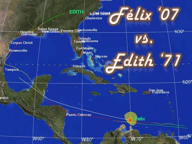
jhamps10 wrote:from the looks of windstorm's image, felix is right now going north of ALL the models. I agree gatorcane, NW gom really should keep an eye on this, I for one am feeling a bit better for Honduras and Belize right now, and more concerned about the Yucatan part of mexico.


Folks don't get me wrong. I do think a tragedy could be unfolding for those in Honduras/Nicaragua.....and my thoughts and prayers go out to them....although I think the system will end up north of Honduras (hopefully enough for them to miss the bulk of the winds)..

but I don't want those in the NW and N GOM to think this is going to be just like Dean as far as path. I have seen too many complacent comments of this nature. Its unlikely we ever see two back to back paths that are the same.
0 likes   

User avatar
ROCK
Category 5
Category 5
Posts: 9484
Age: 54
Joined: Tue Aug 17, 2004 7:30 am
Location: Kemah, Texas

Re: Hurricane FELIX:Caribbean-Discussions & Imagery 11AM pag 30

#602 Postby ROCK » Sun Sep 02, 2007 9:58 am

Windstorm, that is an awesome site with track overlays. Care to share?? :D
0 likes   

CrazyC83
Professional-Met
Professional-Met
Posts: 34002
Joined: Tue Mar 07, 2006 11:57 pm
Location: Deep South, for the first time!

#603 Postby CrazyC83 » Sun Sep 02, 2007 10:00 am

It's a "pick your poison" right now. If it turns, that could spare from having a death toll in the thousands, but puts the Yucatan and the northern Gulf in much greater risk.
0 likes   

User avatar
windstorm99
S2K Supporter
S2K Supporter
Posts: 1578
Age: 47
Joined: Sat May 26, 2007 8:10 am
Location: Miami, Florida
Contact:

Re: Hurricane FELIX:Caribbean-Discussions & Imagery 11AM pag 30

#604 Postby windstorm99 » Sun Sep 02, 2007 10:01 am

ROCK wrote:Windstorm, that is an awesome site with track overlays. Care to share?? :D


Sure its actually the new CIMSS website.It has a way to save animations with quikscat overlaid and tons of other images.
0 likes   

User avatar
El Nino
Category 1
Category 1
Posts: 454
Age: 47
Joined: Sun Oct 16, 2005 3:18 pm
Location: Lima - Miraflores (Peru)
Contact:

Re: Hurricane FELIX:Caribbean-Discussions & Imagery 11AM pag 30

#605 Postby El Nino » Sun Sep 02, 2007 10:01 am

This thing will be 36h in then zone when Wilma was born. I don't like this.
0 likes   

User avatar
HURAKAN
Professional-Met
Professional-Met
Posts: 46086
Age: 38
Joined: Thu May 20, 2004 4:34 pm
Location: Key West, FL
Contact:

#606 Postby HURAKAN » Sun Sep 02, 2007 10:02 am

Image

I will have to talk first to the NBA referee, but I can bet as much as I want that this is at least a cat. 3.
0 likes   

User avatar
TampaFl
S2K Supporter
S2K Supporter
Posts: 1904
Age: 67
Joined: Thu Sep 04, 2003 11:23 am
Location: Tampa, FL

Re: Hurricane FELIX:Caribbean-Discussions & Imagery 11AM pag 30

#607 Postby TampaFl » Sun Sep 02, 2007 10:03 am

ROCK wrote:Windstorm, that is an awesome site with track overlays. Care to share?? :D


Here you go, just click on the Felix icon & have fun!

http://cimss.ssec.wisc.edu/tropic2/#
Last edited by TampaFl on Sun Sep 02, 2007 10:04 am, edited 1 time in total.
0 likes   

User avatar
HURAKAN
Professional-Met
Professional-Met
Posts: 46086
Age: 38
Joined: Thu May 20, 2004 4:34 pm
Location: Key West, FL
Contact:

#608 Postby HURAKAN » Sun Sep 02, 2007 10:04 am

Image

Match made in heaven. Almost twins.
0 likes   

User avatar
windstorm99
S2K Supporter
S2K Supporter
Posts: 1578
Age: 47
Joined: Sat May 26, 2007 8:10 am
Location: Miami, Florida
Contact:

Re: Hurricane FELIX:Caribbean-Discussions & Imagery 11AM pag 30

#609 Postby windstorm99 » Sun Sep 02, 2007 10:09 am

Another infrared view of felix...

Image
0 likes   

User avatar
Steve
S2K Supporter
S2K Supporter
Posts: 9621
Joined: Sat Apr 05, 2003 11:41 pm
Location: Not a state-caster

#610 Postby Steve » Sun Sep 02, 2007 10:13 am

>>have been saying for several days now a turn to the NW or N at the end of the forecast period seems likely given that persistent ridging is less likely now then in mid August........

It's not fall yet, and the summer patter was late getting here. There is a possible flip to some east coast troughiness based off of what's going on the WPAC. It may be that Felix is too far south or too fast to teleconnect with Fitow. But it's not like strong cold fronts are coming down in droves at this time of year. Yeah, the later you get in the year, the better your chance of troughs. But persistence of ridging depends on the pattern setup and how long the Southeast US is staying in its summer and late summer patterns. IMHO, whatever happens off the US East Coast in the 7 day range is transient or at least relatively short lived.

Steve
0 likes   

Zardoz
Category 1
Category 1
Posts: 309
Joined: Fri Aug 25, 2006 9:48 am
Location: Severe weather-challenged Southern California

Re: Hurricane FELIX:Caribbean-Discussions & Imagery 11AM pag 30

#611 Postby Zardoz » Sun Sep 02, 2007 10:13 am

TampaFl wrote:Here you go, just click on the Felix icon & have fun!

http://cimss.ssec.wisc.edu/tropic2/#

Thank you!
0 likes   

PhillyWX
Category 1
Category 1
Posts: 494
Joined: Tue Aug 30, 2005 8:54 am
Location: Philly
Contact:

#612 Postby PhillyWX » Sun Sep 02, 2007 10:23 am

0 likes   

User avatar
HouTXmetro
Category 5
Category 5
Posts: 3949
Joined: Sun Jun 13, 2004 6:00 pm
Location: District of Columbia, USA

Re: Hurricane FELIX:Caribbean-Discussions & Imagery 11AM pag 30

#613 Postby HouTXmetro » Sun Sep 02, 2007 10:29 am

Was Texas still in the cone of uncertainty for Dean this far out?
0 likes   

PhillyWX
Category 1
Category 1
Posts: 494
Joined: Tue Aug 30, 2005 8:54 am
Location: Philly
Contact:

Re: Hurricane FELIX:Caribbean-Discussions & Imagery 11AM pag 30

#614 Postby PhillyWX » Sun Sep 02, 2007 10:34 am

HouTXmetro wrote:Was Texas still in the cone of uncertainty for Dean this far out?


Yes...in fact the GFDL was calling for a Louisiana hit at this point I believe.
0 likes   

Brent
S2K Supporter
S2K Supporter
Posts: 38090
Age: 36
Joined: Sun May 16, 2004 10:30 pm
Location: Tulsa Oklahoma
Contact:

Re: Hurricane FELIX:Caribbean-Discussions & Imagery 11AM pag 30

#615 Postby Brent » Sun Sep 02, 2007 10:36 am

HouTXmetro wrote:Was Texas still in the cone of uncertainty for Dean this far out?


I believe so, the NHC doesn't have the 5-day position inland anywhere(on one Dean projected path they had it approaching Brownsville on Day 5). The average 5-day error is 300 miles, and remember that a couple of models actually did show a TX hit.

Anyway.... Felix looks like a major hurricane right now. I fully expect a Cat 4 by tonight with that satellite appearance.
0 likes   

User avatar
HURAKAN
Professional-Met
Professional-Met
Posts: 46086
Age: 38
Joined: Thu May 20, 2004 4:34 pm
Location: Key West, FL
Contact:

#616 Postby HURAKAN » Sun Sep 02, 2007 10:41 am

Image

Image

Image

These images will become very useful as Félix moves WNW.
0 likes   

User avatar
Nimbus
Category 5
Category 5
Posts: 5300
Joined: Mon Jul 19, 2004 10:54 am

Re: Hurricane FELIX:Caribbean-Discussions & Imagery 11AM pag 30

#617 Postby Nimbus » Sun Sep 02, 2007 10:46 am

Think we need to talk about model trends instead of single run outputs.

The water vapor imagery is showing a large clockwise rotation over the Caribbean.

http://wwwghcc.msfc.nasa.gov/GOES/goeseasthurrwv.html

There is a counter clockwise spin over Western Texas. This kind of dynamic environment does not lend itself to linear forecast tracks. Spiral sections and curves do a better job. A track like Edith is not out of the question. I expect the next set of 24 hour locations will be further north.
0 likes   

Javlin
Category 5
Category 5
Posts: 1620
Age: 64
Joined: Fri Jul 09, 2004 7:58 pm
Location: ms gulf coast

Re: Hurricane FELIX:Caribbean-Discussions & Imagery 11AM pag 30

#618 Postby Javlin » Sun Sep 02, 2007 11:02 am

Nimbus wrote:Think we need to talk about model trends instead of single run outputs.

The water vapor imagery is showing a large clockwise rotation over the Caribbean.

http://wwwghcc.msfc.nasa.gov/GOES/goeseasthurrwv.html

There is a counter clockwise spin over Western Texas. This kind of dynamic environment does not lend itself to linear forecast tracks. Spiral sections and curves do a better job. A track like Edith is not out of the question. I expect the next set of 24 hour locations will be further north.

Yea you actually have an ULL over the Keys,over the Bay of Honduras? and as you mentioned over the TX and MX border.The thing I always thought applied is that where ever a low WAS filled in quite quickly with high pressure.That being said and if correct looks like maybe more like the NHC path without a N'ward turn later.
0 likes   

User avatar
Cape Verde
Category 2
Category 2
Posts: 564
Age: 69
Joined: Tue Aug 31, 2004 5:53 pm
Location: Houston area

Re: Hurricane FELIX:Caribbean-Discussions & Imagery 11AM pag 30

#619 Postby Cape Verde » Sun Sep 02, 2007 11:04 am

I have no weather expertise other than what I've learned at this forum. But I know enough that Felix will attempt to circle the ridge to its north. How strong that ridge will be and whether it moves will determine Felix's course.

Looking at the current maps, it's wide open between northern Central America, and perhaps as far east as Louisiana. Perhaps somebody can set me straight.
0 likes   

Sanibel
Category 5
Category 5
Posts: 10375
Joined: Mon Aug 30, 2004 11:06 pm
Location: Offshore SW Florida

Re: Hurricane FELIX:Caribbean-Discussions & Imagery 11AM pag 30

#620 Postby Sanibel » Sun Sep 02, 2007 11:07 am

Wobble back west. Right on trop points. Expect near miss of Honduras and serious hurricane into Belize.
0 likes   


Return to “2007”

Who is online

Users browsing this forum: No registered users and 14 guests