TD INGRID: Discussions & Images - Last Advisory

Moderator: S2k Moderators

Message
Author
JTD
Category 5
Category 5
Posts: 1558
Joined: Sun Nov 02, 2003 6:35 pm

Re: Trop Dep EIGHT (ATL): Discussions & Images 5 PM EDT page 87

#1781 Postby JTD » Thu Sep 13, 2007 4:55 pm

Tampa Bay Hurricane wrote:http://www.srh.noaa.gov/productview.php?pil=AFDMLB&max=10

OUT OF MELBOURNE-
VERY STRONG RIDGE with Atlantic ridge merging with a contental
ridge. TD 8 will likely NOT recurve.
Mon-thu this thing goes WNW for 7 days..that would
bring it to the Bahamas...

gatorcane mentioned this earlier.

MON-THU...THE CONTINENTAL RIDGE RIDING BEHIND THE DEVELOPING
STORM SYSTEM WILL PUSH INTO NEW ENGLAND EARLY NEXT WEEK WHERE IT
WILL MERGE WITH THE ATLC RIDGE. WITH THE RIDGE AXIS LOCATED SO FAR
TO THE N...ANY STORM SYSTEMS THAT DEVELOP OVER THE CONUS WILL BE
FORCED UP THE BACKSIDE OF THE RIDGE WHERE THEIR ABILITY TO PUSH
THE RIDGE AXIS BACK TO THE S WILL BE GREATLY LIMITED. THE RESULT
WILL BE A DOMINANT ERLY FLOW REGIME THROUGH MOST OF NEXT WEEK.
THESE ERLIES COULD PUSH A T-WAVE ACROSS FL BY MID WEEK.


Hmmm....storm under a potentially strong ridge heading in the general direction of Florida :eek: That is never something that you want to see. Thanks for posting that TBH. One would think that a storm under a strong ridge wouldn't get sheared by 40-50 knots either.

Punkyg,

that JPEG that you posted shows TD #8 to be looking rather healthy at the moment. Looking very good indeed. I think recon finds a definite tropical storm.
0 likes   

User avatar
windstorm99
S2K Supporter
S2K Supporter
Posts: 1578
Age: 47
Joined: Sat May 26, 2007 8:10 am
Location: Miami, Florida
Contact:

Re: Trop Dep EIGHT (ATL): Discussions & Images 5 PM EDT page 87

#1782 Postby windstorm99 » Thu Sep 13, 2007 4:59 pm

Again this is forcasted to be a TD at the end of the forcasted period which as of right now is not a significant worry.Hopefully it can avoid the islands.
0 likes   

User avatar
ronjon
Category 5
Category 5
Posts: 4822
Joined: Fri Aug 19, 2005 5:17 pm
Location: Hernando Beach, FL

Re: Trop Dep EIGHT (ATL): Discussions & Images 5 PM EDT page 87

#1783 Postby ronjon » Thu Sep 13, 2007 5:03 pm

I'm starting to get a little concerned about the synoptic setup early to middle part of next week. Whether or not TD 8 survives the next couple of days and becomes a tropical storm in the near term I don't think is the issue now. A sprawling mega high is progged to build off the mid-atlantic coast early next week and the models are showing low pressure now moving across the FL peninsula sometime on Wednesday and then into the GOM. The low pressure that is forecasted is both at the surface and 500 mb so its unclear to me if this will be a cutoff ULL or something more hybrid. What is a little worrisome is that at the base of these sprawling high pressure systems you get surface convergence which often spins up convective masses. This I believe was a similar set up for Katrina's development. Couple in the fact that you might have baroclinic energy, say as the spark to light the fire, with the mid-level energy, means that some type of storm could get going east of FL. The 12Z Euro brings a piece of this energy across FL and develops a system in the GOM. Steering currents, as progged, would bring anything east of FL across the state. If something develops, I would look at the area east of the Bahamas as the focal point.
0 likes   

User avatar
storms in NC
S2K Supporter
S2K Supporter
Posts: 2338
Joined: Thu Jul 28, 2005 2:58 pm
Location: Wallace,NC 40 miles NE of Wilm
Contact:

#1784 Postby storms in NC » Thu Sep 13, 2007 5:03 pm

From what I just read from Marks site. Is about the way I feel about the rest of the year for the east coast. :D 8-) :wink:
0 likes   

aguaviva
Tropical Low
Tropical Low
Posts: 45
Joined: Fri Aug 17, 2007 6:09 pm

Re: Trop Dep EIGHT (ATL): Discussions & Images 5 PM EDT page 87

#1785 Postby aguaviva » Thu Sep 13, 2007 5:04 pm

windstorm99 wrote:Again this is forcasted to be a TD at the end of the forcasted period which as of right now is not a significant worry.Hopefully it can avoid the islands.


I think what they are concerned about is that after the end of the end of the forecast period it still alive and that at that point conditions for intensification improve.
0 likes   

User avatar
fci
S2K Supporter
S2K Supporter
Posts: 3324
Joined: Tue Sep 14, 2004 10:29 am
Location: Lake Worth, FL

Re:

#1786 Postby fci » Thu Sep 13, 2007 5:09 pm

jhamps10 wrote:it wouldn't suprise me if RECON did NOT find a TS, but it would not suprise me either if they did find it was a TS, with the way it is looking on satellite, espically since we are very close to DMIN.


It is great to see you take a stand!
8-)
0 likes   

User avatar
windstorm99
S2K Supporter
S2K Supporter
Posts: 1578
Age: 47
Joined: Sat May 26, 2007 8:10 am
Location: Miami, Florida
Contact:

Re: Trop Dep EIGHT (ATL): Discussions & Images 5 PM EDT page 87

#1787 Postby windstorm99 » Thu Sep 13, 2007 5:09 pm

aguaviva wrote:
windstorm99 wrote:Again this is forcasted to be a TD at the end of the forcasted period which as of right now is not a significant worry.Hopefully it can avoid the islands.


I think what they are concerned about is that after the end of the end of the forecast period it still alive and that at that point conditions for intensification improve.


Correct...Could be a problem.
0 likes   

User avatar
BigA
Professional-Met
Professional-Met
Posts: 1317
Joined: Sun Jul 24, 2005 10:56 pm

Re: Trop Dep EIGHT (ATL): Discussions & Images 5 PM EDT page 87

#1788 Postby BigA » Thu Sep 13, 2007 5:14 pm

windstorm99 wrote:
aguaviva wrote:
windstorm99 wrote:Again this is forcasted to be a TD at the end of the forcasted period which as of right now is not a significant worry.Hopefully it can avoid the islands.


I think what they are concerned about is that after the end of the end of the forecast period it still alive and that at that point conditions for intensification improve.


Correct...Could be a problem.


I cant really see this as a 30 knot tropical depression in 120 hours. It seems to me that it will either be able to evade some of the worst shear, and stay as a moderate TS, or it will be utterly destroyed by the shear. I dont see too many systems that just sort of muddle their way westward as TDs.

Even if this thing does get ripped apart in the 72-120 hr timeframe, when it moves into better conditions near the Bahamas, the East Coast needs to watch it.
0 likes   

User avatar
canegrl04
Category 5
Category 5
Posts: 2486
Joined: Thu Aug 26, 2004 5:37 pm
Location: Texas

Re: Trop Dep EIGHT (ATL): Discussions & Images 5 PM EDT page 87

#1789 Postby canegrl04 » Thu Sep 13, 2007 5:21 pm

Tampa Bay Hurricane wrote:http://www.srh.noaa.gov/productview.php?pil=AFDMLB&max=10

OUT OF MELBOURNE-
VERY STRONG RIDGE with Atlantic ridge merging with a contental
ridge. TD 8 will likely NOT recurve.
Mon-thu this thing goes WNW for 7 days..that would
bring it to the Bahamas...

gatorcane mentioned this earlier.

MON-THU...THE CONTINENTAL RIDGE RIDING BEHIND THE DEVELOPING
STORM SYSTEM WILL PUSH INTO NEW ENGLAND EARLY NEXT WEEK WHERE IT
WILL MERGE WITH THE ATLC RIDGE. WITH THE RIDGE AXIS LOCATED SO FAR
TO THE N...ANY STORM SYSTEMS THAT DEVELOP OVER THE CONUS WILL BE
FORCED UP THE BACKSIDE OF THE RIDGE WHERE THEIR ABILITY TO PUSH
THE RIDGE AXIS BACK TO THE S WILL BE GREATLY LIMITED. THE RESULT
WILL BE A DOMINANT ERLY FLOW REGIME THROUGH MOST OF NEXT WEEK.
THESE ERLIES COULD PUSH A T-WAVE ACROSS FL BY MID WEEK.


I hope this doesn't come to pass.Otherwise,Florida and the Gulf have alot to worry about next week :eek: I noticed the media aren't even mentioning td 8 right now,but after this becomes Ingrid,they'll be all over it
0 likes   

JTD
Category 5
Category 5
Posts: 1558
Joined: Sun Nov 02, 2003 6:35 pm

Re: Trop Dep EIGHT (ATL): Discussions & Images 5 PM EDT page 87

#1790 Postby JTD » Thu Sep 13, 2007 5:24 pm

Just checked out all of the visibles on the NHC site,

TD #8 is looking impressive this afternoon. Starting to take on a circular appearance. Dark red in the center. Looks good on Dvorak IR as well. I'm guessing recon finds a 45 mph tropical storm.
0 likes   

Brent
S2K Supporter
S2K Supporter
Posts: 38091
Age: 36
Joined: Sun May 16, 2004 10:30 pm
Location: Tulsa Oklahoma
Contact:

Re: Trop Dep EIGHT (ATL): Discussions & Images 5 PM EDT page 87

#1791 Postby Brent » Thu Sep 13, 2007 5:24 pm

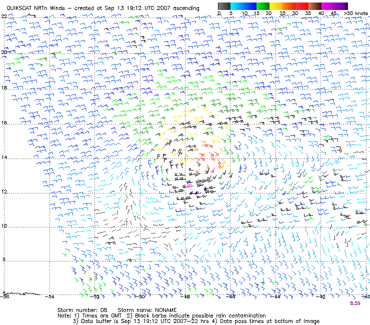
New quikscat... pretty obvious. Very well-defined LLC and some TS wind barbs.


Image
0 likes   

Matt-hurricanewatcher

Re: Trop Dep EIGHT (ATL): Discussions & Images 5 PM EDT page 87

#1792 Postby Matt-hurricanewatcher » Thu Sep 13, 2007 5:26 pm

Its been obvious for almost the last day and a half. Recon should do one of two things, make me right or make me wrong. One way or the other it was worth debating.
0 likes   

User avatar
brunota2003
S2K Supporter
S2K Supporter
Posts: 9476
Age: 34
Joined: Sat Jul 30, 2005 9:56 pm
Location: Stanton, KY...formerly Havelock, NC
Contact:

Re: Trop Dep EIGHT (ATL): Discussions=Latest Quickscat at page 8

#1793 Postby brunota2003 » Thu Sep 13, 2007 5:27 pm

Is that a couple of 55 knot, uncontaminated, wind vecors I see on QuikScat?
0 likes   

Matt-hurricanewatcher

Re: Trop Dep EIGHT (ATL): Discussions=Latest Quickscat at page 8

#1794 Postby Matt-hurricanewatcher » Thu Sep 13, 2007 5:28 pm

brunota2003 wrote:Is that a couple of 55 knot, uncontaminated, wind vecors I see on QuikScat?


It would not suprize me, Alberto had almost hurricane winds in the LLC was exposed.
0 likes   

CrazyC83
Professional-Met
Professional-Met
Posts: 34002
Joined: Tue Mar 07, 2006 11:57 pm
Location: Deep South, for the first time!

#1795 Postby CrazyC83 » Thu Sep 13, 2007 5:30 pm

I'd say 40-45 kt TS Ingrid right now.
0 likes   

CrazyC83
Professional-Met
Professional-Met
Posts: 34002
Joined: Tue Mar 07, 2006 11:57 pm
Location: Deep South, for the first time!

Re: Trop Dep EIGHT (ATL): Discussions=Latest Quickscat at page 8

#1796 Postby CrazyC83 » Thu Sep 13, 2007 5:31 pm

brunota2003 wrote:Is that a couple of 55 knot, uncontaminated, wind vecors I see on QuikScat?


That looks like 45 kt uncontaminated and 55 kt contaminated.
0 likes   

User avatar
HURAKAN
Professional-Met
Professional-Met
Posts: 46086
Age: 38
Joined: Thu May 20, 2004 4:34 pm
Location: Key West, FL
Contact:

#1797 Postby HURAKAN » Thu Sep 13, 2007 5:35 pm

Latest:

Image

TD 8 making a comeback.
0 likes   

O Town
S2K Supporter
S2K Supporter
Posts: 5205
Age: 52
Joined: Wed Sep 07, 2005 9:37 pm
Location: Orlando, Florida 28°35'35"N 81°22'55"W

#1798 Postby O Town » Thu Sep 13, 2007 5:36 pm

Okay could someone please explain to me how to tell if the barbs are contaminated or not. I heard this said on a few different occasions and just want to know so I can determine that as well. Thanks.
0 likes   

User avatar
brunota2003
S2K Supporter
S2K Supporter
Posts: 9476
Age: 34
Joined: Sat Jul 30, 2005 9:56 pm
Location: Stanton, KY...formerly Havelock, NC
Contact:

Re: Trop Dep EIGHT (ATL): Discussions=Latest Quickscat at page 8

#1799 Postby brunota2003 » Thu Sep 13, 2007 5:37 pm

CrazyC83 wrote:
brunota2003 wrote:Is that a couple of 55 knot, uncontaminated, wind vecors I see on QuikScat?


That looks like 45 kt uncontaminated and 55 kt contaminated.

The Penants are 50 knots...and on the South side, there are 3 or 4 of those, including a couple with an additional barb. Black is rain contaminated, those are purple.
0 likes   

User avatar
jasons2k
Storm2k Executive
Storm2k Executive
Posts: 8245
Age: 51
Joined: Wed Jul 06, 2005 12:32 pm
Location: The Woodlands, TX

Re:

#1800 Postby jasons2k » Thu Sep 13, 2007 5:39 pm

O Town wrote:Okay could someone please explain to me how to tell if the barbs are contaminated or not. I heard this said on a few different occasions and just want to know so I can determine that as well. Thanks.


Read the legend on the image. Black barbs are contaminated. :wink:
0 likes   


Return to “2007”

Who is online

Users browsing this forum: No registered users and 5 guests