be the center is moving NW. It's just probably
my eyes playing tricks on me again.
http://www.ssd.noaa.gov/goes/flt/t1/loop-vis.html
Moderator: S2k Moderators


skysummit wrote:Air Force Met wrote:skysummit wrote:I would like to see what wxman57 says now that the EURO has shifted east. What is his thinking regarding this......
Probably not much of a change...he's been saying SW LA...and that is about where the EURO is taking this.
Yea, that's what I thought. AFM, do you think we should disregard the tropical models even though they were initalized correctly? I don't understand why they're showing a northwest movement right off the back.
Are you going primarily with the EURO too?
Air Force Met wrote:Yes and yes.
Yes to the 1st question because this isn't in the tropics and it is in a changing flow type situation and yes to the second question because when you are in the playoffs...you want Payton Manning starting at QB (at least lately) IT has the hot hand and until it starts rolling snake eyes...I am reluctant to bet against it and go with some other model that hasn't been performing that well. Learned my lesson after Dean.

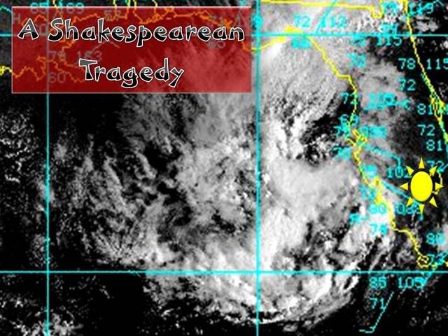
Derek Ortt wrote:not looking the greatest this morning. Only have shallow convection over the center; thus, we should not see significant intensification. The UL is not going anywhere
Looks like we could have a marginal to moderate TS striking the coast on Saturday. 40% chance of development
caneman wrote:Very disorganized. Seems to be creeping NNw not far from Tampa perhaps Sarasota. Much of the moisture got blown out NE last night. Within only about 48 hours til landfall, I would be shocked if it became anything significant.
Derek Ortt wrote:if it were my decision, all recon would be cancelled for today on this system... there is nothing to fly


Ed Mahmoud wrote:caneman wrote:Very disorganized. Seems to be creeping NNw not far from Tampa perhaps Sarasota. Much of the moisture got blown out NE last night. Within only about 48 hours til landfall, I would be shocked if it became anything significant.
And Air Force Met's plans for the weekend are not disturbed.
And Joe Bastardi gets -5 for calling Texas, but still gets a 'B' for calling for a piece of the polar trough to break off and start a non-tropical to sub-tropical development. He'd get an A-, except his suggestions of a hurricane looks a shade too aggressive.
Makes him 4.5 for 6 this season on calling development from non-purely tropical sources.


MWatkins wrote:Hmmm...
Clearly 93L is not any better organized this morning, although it is nice to see the center getting initialized correctly in the 12Z hurricane guidance.
One thing I noticed this morning is 93L...being a broad upper low and all...seems to be bending some of the stronger westerlies out of the Caribbean.
http://www.ssd.noaa.gov/goes/east/tatl/loop-wv.html
Yes there is still difluent flow down there...but perhaps...perhaps by deflecting the westerlies it will allow for a more favorable upper environment for anything trying to get going...say in the western Caribbean.
The GFS solution for create-a-storm development in 48 hours west of cuba seems dubious...but I wonder if it is sniffing out that disturbance down there.
Obviously will need to watch that longer...it already looks like cloud tops are starting to warm...but there were some cold cloud tops down there earlier...
MW
Derek Ortt wrote:I doubt there are 40 mph winds anywhere near this system. This does not justify recon today as this deos not fit the definition of a TD (a closed circulation with organized convection). We are missin the second part. Reschedule the flights for tomorrow
Users browsing this forum: No registered users and 67 guests