At at least 2 locations. Quite a pressure differential from this area and surrounding areas as well.
http://www.ndbc.noaa.gov/station_page.php?station=42003
About a .20 pressure differential from this area and locations North of it.
Looks good on SAt.
http://www.ssd.noaa.gov/goes/east/gmex/avn-l.jpg
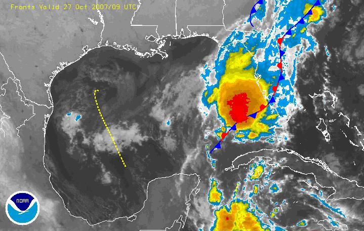
GOM-Producing near TD strength winds
Moderator: S2k Moderators
Forum rules

The posts in this forum are NOT official forecasts and should not be used as such. They are just the opinion of the poster and may or may not be backed by sound meteorological data. They are NOT endorsed by any professional institution or STORM2K. For official information, please refer to products from the National Hurricane Center and National Weather Service.
-
caneman
Re: GOM-Producing near TD strength winds
According to the 8:00 NHC update. This area has become stationary
0 likes

Re: GOM-Producing near TD strength winds
On infrared imagery, looks like there is a low or mid-level center near 23.7N 85.9W. I'm not sure if this is the surface low that was in the NW Carribean yesterday, but it's under high wind shear right now with the thunderstorm complex well NW of the center.
0 likes
-
Tampa Bay Hurricane

- Category 5

- Posts: 5597
- Age: 38
- Joined: Fri Jul 22, 2005 7:54 pm
- Location: St. Petersburg, FL
-
Tampa Bay Hurricane
- Category 5
- Posts: 5597
- Age: 38
- Joined: Fri Jul 22, 2005 7:54 pm
- Location: St. Petersburg, FL

-
caneman
-
caneman
WOW! Quickscat is showing some 40kt. + winds occuring. I saw a ship reporting this as well but had discounted due to faulty equipment but.........
http://manati.orbit.nesdis.noaa.gov/oce ... atl_12.png
http://manati.orbit.nesdis.noaa.gov/oce ... atl_12.png
0 likes
-
caneman
Re: GOM-Producing near TD strength winds
If these are tur winds, it looks to me like a invest and STDS are in order.
0 likes
Re:
caneman wrote:WOW! Quickscat is showing some 40kt. + winds occuring. I saw a ship reporting this as well but had discounted due to faulty equipment but.........
http://manati.orbit.nesdis.noaa.gov/oce ... atl_12.png
The QS pass doesn't show a closed surface circulation. Looks more like inverted surface trof extending down into the NW Carribean. Visible imagery this mornng seems to show that too. I take back what I said about LLC or MLC.
0 likes
-
Tampa Bay Hurricane
- Category 5
- Posts: 5597
- Age: 38
- Joined: Fri Jul 22, 2005 7:54 pm
- Location: St. Petersburg, FL
-
Tampa Bay Hurricane
- Category 5
- Posts: 5597
- Age: 38
- Joined: Fri Jul 22, 2005 7:54 pm
- Location: St. Petersburg, FL


Re: GOM-Producing near TD strength winds
That's just west of us. It has the look, but I don't see any spiral except a little vortex out from under the convection to the west along the stationary boundary. GOM is 82-84*
Calm here no rain.
Calm here no rain.
0 likes
-
JonathanBelles
- Professional-Met

- Posts: 11430
- Age: 35
- Joined: Sat Dec 24, 2005 9:00 pm
- Location: School: Florida State University (Tallahassee, FL) Home: St. Petersburg, Florida
- Contact:
-
Rainband
Re:
This is not going to affect Florida. It should stay off shore. Most of the heavy rain will too. Too much shear.Cyclone1 wrote:11:30 TWO approaching... I hope the NHC mentions this. Personally, I don't think they have a choice. A lot of storm leery Floridians are going to be logging on to the NHC after seeing this blob on TWC Local on the 8's and read the TWO.
http://www.srh.noaa.gov/productview.php ... &version=0
0 likes
Re: Re:
Rainband wrote:This is not going to affect Florida. It should stay off shore. Most of the heavy rain will too. Too much shear.Cyclone1 wrote:11:30 TWO approaching... I hope the NHC mentions this. Personally, I don't think they have a choice. A lot of storm leery Floridians are going to be logging on to the NHC after seeing this blob on TWC Local on the 8's and read the TWO.
http://www.srh.noaa.gov/productview.php ... &version=0
It's right off the coast. Whether or not it affects Florida doesn't really matter, it's near Florida, and that's going to catch the interest of a lot of Floridians.
The NHC should have something telling them at the least that development isn't expected.
And, for the record, it's already affecting Florida, but I see what you're saying.
0 likes
Who is online
Users browsing this forum: No registered users and 47 guests