Thunderstorm Cluster offshore West Central Florida

U.S. & Caribbean Weather Discussions and Severe Weather Events

Moderator: S2k Moderators

Forum rules

The posts in this forum are NOT official forecast and should not be used as such. They are just the opinion of the poster and may or may not be backed by sound meteorological data. They are NOT endorsed by any professional institution or STORM2K.

Help Support Storm2K
Message
Author
User avatar
tbstorm
Tropical Storm
Tropical Storm
Posts: 135
Joined: Sun Oct 09, 2005 7:33 pm
Location: St. Petersburg, FL

Thunderstorm Cluster offshore West Central Florida

#1 Postby tbstorm » Sat Dec 15, 2007 3:00 am

Looks like there is a potential squall line that will develop from the cold front expected to move through Florida on Dec 17.

I am curious to see if the remanent spin from ex-Olga currently over the Yucatan can be advected into the west coast of Florida, I believe that would be the scenario that could energize said squall line and would give a potential tornado threat to Florida.

Latest models have the squall line moving through the Tampa Bay area 4am - 8am Sunday
Image
Last edited by tbstorm on Sun Dec 16, 2007 1:22 am, edited 6 times in total.
0 likes   

JonathanBelles
Professional-Met
Professional-Met
Posts: 11430
Age: 35
Joined: Sat Dec 24, 2005 9:00 pm
Location: School: Florida State University (Tallahassee, FL) Home: St. Petersburg, Florida
Contact:

#2 Postby JonathanBelles » Sat Dec 15, 2007 11:36 am

I've had this hunch for a few days. Clash of very different air masses should be very interesting. Its gonna be a long night.
0 likes   

User avatar
tbstorm
Tropical Storm
Tropical Storm
Posts: 135
Joined: Sun Oct 09, 2005 7:33 pm
Location: St. Petersburg, FL

Re: Florida-Squall Line Sunday Morning... a tropical connection?

#3 Postby tbstorm » Sat Dec 15, 2007 12:51 pm

Aha... just as I suspected

Code: Select all

NWS STORM PREDICTION CENTER NORMAN OK
   1026 AM CST SAT DEC 15 2007

ANOTHER COMPLICATING FACTOR TO THE FORECAST INVOLVES THE REMNANT
   CIRCULATION OF OLGA...NOW NEAR 22.8N/-87.9W.  THIS FEATURE WILL
   BECOME ENTRAINED IN STRONGER SOUTHWESTERLY LOW/MID LEVEL WINDS AND
   APPROACH THE FL PENINSULA OVERNIGHT.  IF ENHANCED LOW LEVEL VERTICAL
   SHEAR IS PRESENT IN NORTHEAST QUADRANT OF LOW...POTENTIAL WOULD
   EXIST FOR OVERNIGHT ISOLATED TORNADOES/DAMAGING WINDS ACROSS
   NORTHERN/CENTRAL FL PENINSULA.


Map of Latitude 22.8 Longitude -87.9, by MapQuest
Image
0 likes   

User avatar
tbstorm
Tropical Storm
Tropical Storm
Posts: 135
Joined: Sun Oct 09, 2005 7:33 pm
Location: St. Petersburg, FL

#4 Postby tbstorm » Sat Dec 15, 2007 2:51 pm

Looks like we may be seeing the begninning of the squall line developing invo Pensacola. Quite a large circulation around ex-Olga BTW.
Image
0 likes   

JonathanBelles
Professional-Met
Professional-Met
Posts: 11430
Age: 35
Joined: Sat Dec 24, 2005 9:00 pm
Location: School: Florida State University (Tallahassee, FL) Home: St. Petersburg, Florida
Contact:

#5 Postby JonathanBelles » Sat Dec 15, 2007 4:51 pm

... A Tornado Warning remains in effect until 415 PM CST for Houston
County in southeast Alabama...

At 342 PM CST... National Weather Service Doppler radar continued to
indicate a tornado. This tornado was located near Memphis... or
about 5 miles south of downtown Dothan... moving northeast at 45 mph.

The tornado will be near...
downtown Dothan by 355 PM CST
Pleasant Plains and sigma by 400 PM CST...

Relay reports of severe weather to the National Weather Service in
Tallahassee at (8 5 0) 9 4 2 8 8 3 3. Or... you may contact the
nearest law enforcement agency or your County emergency management.
They will relay your report to the National Weather Service.

A Tornado Watch remains in effect until 1000 PM CST Saturday evening
for southeast Alabama and central Florida and southwestern Georgia.

Lat... Lon 3130 8512 3118 8512 3117 8513 3110 8511
3102 8546 3107 8549 3120 8549 3132 8540
time... Mot... loc 2146z 216deg 46kt 3120 8534
0 likes   

flwxwatcher
Category 4
Category 4
Posts: 926
Joined: Wed May 16, 2007 3:35 pm
Location: Central Florida

Re: Florida-Squall Line and Severe Weather Threat

#6 Postby flwxwatcher » Sat Dec 15, 2007 5:18 pm

Things are shaping up for some severe weather overnight it appears for Florida. The pre frontal squall line is developing and the remainants and vorticity from ex-olga should add some additional fuel to the fire.
0 likes   

User avatar
Ivanhater
Storm2k Moderator
Storm2k Moderator
Posts: 11161
Age: 38
Joined: Fri Jul 01, 2005 8:25 am
Location: Pensacola

Re: Florida-Squall Line and Severe Weather Threat

#7 Postby Ivanhater » Sat Dec 15, 2007 5:21 pm

Went christmas shopping today..not only battling a billion people at the mall...the rain was coming down hard and wouldnt stop..needless to say I got soaked today...
0 likes   

JonathanBelles
Professional-Met
Professional-Met
Posts: 11430
Age: 35
Joined: Sat Dec 24, 2005 9:00 pm
Location: School: Florida State University (Tallahassee, FL) Home: St. Petersburg, Florida
Contact:

#8 Postby JonathanBelles » Sat Dec 15, 2007 5:27 pm

2022 4 W NAVARRE SANTA ROSA FL 3041 8693 TWO HOMES REPORTEDLY LOSS THEIR ROOFS...POSSIBLE TORNADO DAMAGE. (MOB)
0 likes   

User avatar
tbstorm
Tropical Storm
Tropical Storm
Posts: 135
Joined: Sun Oct 09, 2005 7:33 pm
Location: St. Petersburg, FL

Re: Florida-Squall Line and Severe Weather Threat

#9 Postby tbstorm » Sat Dec 15, 2007 6:41 pm

Ex-Olga is still intact moving rapidly NE, already interacting w/ the squall line in the central gulf to produce some very high cloud tops.

based on current satelite trends, i'm going to go out on a limb and make a prediction for the timing of the squall line:

Code: Select all

Tallahassee 9pm-Midn
Jacksonville Midn-3am
Ocala 1am-4am
Tampa 3am-6am
Orlando 4am-7am


Additionally, looks like, based on extrapolation of satelite imagery ex-Olga should be offshore Tampa Bay approx 100 miles at 2AM. Will be very interesting to say the least.
0 likes   

User avatar
Tampa Bay Hurricane
Category 5
Category 5
Posts: 5597
Age: 37
Joined: Fri Jul 22, 2005 7:54 pm
Location: St. Petersburg, FL

#10 Postby Tampa Bay Hurricane » Sat Dec 15, 2007 7:53 pm

The low circulation from olga will be very interesting when
it interacts with the front- baroclinic enhancement along with
shear are promoting the development of cold cloud tops
in the Gulf.
0 likes   

JonathanBelles
Professional-Met
Professional-Met
Posts: 11430
Age: 35
Joined: Sat Dec 24, 2005 9:00 pm
Location: School: Florida State University (Tallahassee, FL) Home: St. Petersburg, Florida
Contact:

#11 Postby JonathanBelles » Sat Dec 15, 2007 7:58 pm

SPECIAL WEATHER STATEMENT
NATIONAL WEATHER SERVICE TAMPA BAY RUSKIN FL
757 PM EST SAT DEC 15 2007

FLZ039-042-043-048>052-055>057-060>062-065-160700-
LEVY-CITRUS-SUMTER-HERNANDO-PASCO-PINELLAS-HILLSBOROUGH-POLK-
MANATEE-HARDEE-HIGHLANDS-SARASOTA-DE SOTO-CHARLOTTE-LEE-
INCLUDING THE CITIES OF...CEDAR KEY...CHIEFLAND...CRYSTAL RIVER...
INVERNESS...BUSHNELL...THE VILLAGES...BROOKSVILLE...SPRING HILL...
NEW PORT RICHEY...ZEPHYRHILLS...CLEARWATER...ST. PETERSBURG...
BRANDON...TAMPA...LAKELAND...WINTER HAVEN...BRADENTON...
WAUCHULA...SEBRING...AVON PARK...SARASOTA...VENICE...ARCADIA...
PORT CHARLOTTE...PUNTA GORDA...CAPE CORAL...FORT MYERS
757 PM EST SAT DEC 15 2007

...SQUALL LINE TO MOVE OVER THE AREA WITH SEVERE WEATHER POSSIBLE
LATE TONIGHT AND EARLY SUNDAY MORNING...

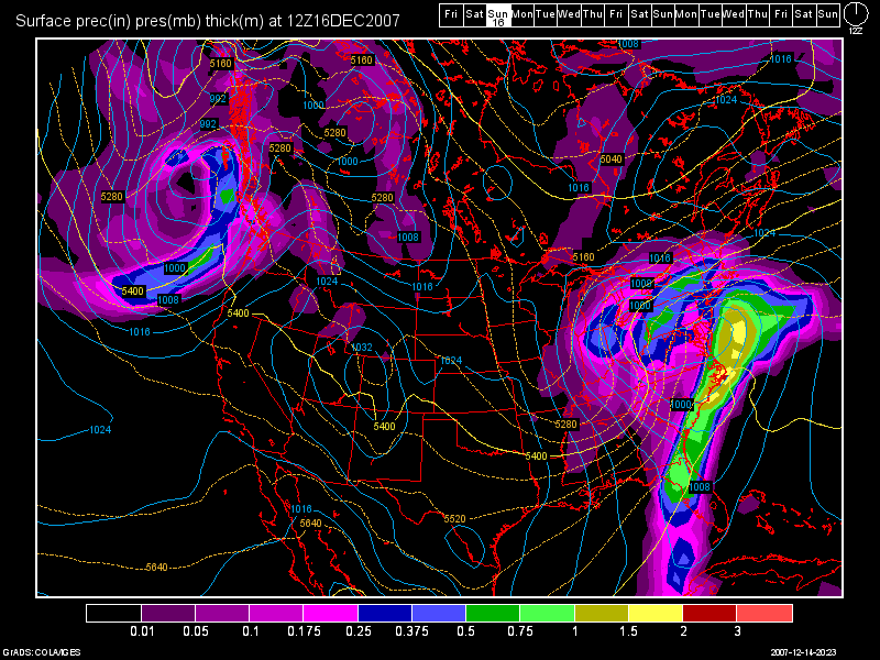
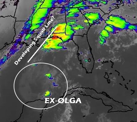
A STRONG PRE FRONTAL TROUGH IS PRODUCING A SQUALL LINE OF STRONG
THUNDERSTORMS THAT IS MOVING INTO EASTERN PORTIONS OF THE FLORIDA
PANHANDLE...THE BIG BEND REGION AND EXTENDING DEEP INTO THE
EASTERN GULF OF MEXICO THIS EVENING.

AT THE PRESENT TIME...THE LINE OF THUNDERSTORMS IS EXPECTED TO MOVE
INTO THE NATURE COAST FROM AROUND MIDNIGHT THROUGH 4 AM...THEN
THROUGH THE TAMPA BAY AREA FROM AROUND 2 AM THROUGH ABOUT SUNRISE
ON SUNDAY AND THROUGH SOUTHWEST FLORIDA DURING SUNDAY MORNING.

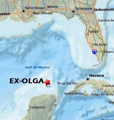
ABUNDANT TROPICAL MOISTURE AND ADDITIONAL LOW LEVEL SHEAR FROM THE
REMNANTS OF TROPICAL FEATURE OLGA ARE ALSO EXPECTED TO MERGE WITH
THE SQUALL LINE AS LARGE SCALE FORCING FROM THE SIGNIFICANT UPPER
LEVEL DISTURBANCE PUSHES ALL THE ACTIVITY INTO THE NORTHERN HALF
OF THE FLORIDA PENINSULA OVERNIGHT.

LATEST MODEL DATA INDICATES A CONTINUED RISK FOR SEVERE WEATHER
ACROSS WEST CENTRAL AND SOUTHWEST FLORIDA OVERNIGHT AND EARLY
SUNDAY MORNING WITH THE PASSAGE OF THIS PRE FRONTAL TROUGH. LOW AND MID
LEVEL WINDS ARE FORECAST TO INCREASE INTO THE 45 TO 55 KNOT RANGE
OVERNIGHT AS LOW AND MID LEVEL JET STREAKS MOVE ACROSS THE REGION
IN ASSOCIATION WITH THE DEVELOPING STORM SYSTEM WELL TO THE NORTH
OF THE REGION. THESE INCREASING WIND FIELDS COMBINED WITH RICH
BOUNDARY LAYER MOISTURE AND SOME ADDITIONAL UPPER LEVEL ENERGY
FROM THE REMNANTS OF OLGA BEING DRAWN NORTHEASTWARD INTO THE
EASTERN GULF WILL SUPPORT THE POSSIBILITY OF DAMAGING WINDS AND
ISOLATED TORNADOES AND MARINE WATERSPOUTS IN THE VICINITY OF
STRONGEST THUNDERSTORMS OVERNIGHT AND EARLY SUNDAY MORNING.
LOCALLY HEAVY RAINS WILL BE ALSO BE POSSIBLE...WHICH MAY CAUSE
MINOR FLOODING OF LOW LYING AND POOR DRAINAGE AREAS AS WELL AS THE
PONDING OF WATER ON ROADWAYS.

CURRENT DATA SUGGESTS THAT THE HIGHEST RISK FOR SEVERE WEATHER WILL
BE FROM THE TAMPA BAY AREA NORTHWARD THROUGH THE NATURE COAST
OVERNIGHT INTO EARLY SUNDAY MORNING WHERE THE STRONGEST FORCING
AND BEST JET DYNAMICS WILL RESIDE WITH ISOLATED SEVERE STORMS
POSSIBLE OVER THE REMAINDER OF WEST CENTRAL AND SOUTHWEST FLORIDA.

IN ADDITION TO THE SEVERE WEATHER SOUTH TO SOUTHWEST WINDS WILL
INCREASE OVER THE ADJACENT GULF WATERS DURING THIS EVENING. WIND
WILL BECOME SOUTHWEST AND INCREASE TO 20 TO 25 KNOTS WITH SEAS
BUILDING TO 5 TO 7 FEET OVERNIGHT...THEN WINDS WILL SHIFT RAPIDLY
INTO THE NORTHWEST AT 20 TO 25 KNOTS WITH SEAS BUILDING TO 8 TO
POSSIBLY 12 FEET WELL OFFSHORE ON SUNDAY AND CONTINUING INTO
MONDAY IN THE WAKE OF THE FRONT. THESE INCREASING WINDS AND SEAS
WILL MAKE FOR VERY ROUGH BOATING CONDITIONS AND ALL SMALL CRAFT
OPERATORS MAY WANT TO POSTPONE TRIPS INTO THE GULF UNTIL CONDITIONS
IMPROVE EARLY NEXT WEEK.

THE DEVELOPING STRONG ONSHORE FLOW ON SUNDAY WILL ALSO PRODUCE
HIGH AND ROUGH SURF...RIP CURRENTS...WITH LARGE BREAKING WAVES
ALONG THE COAST WITH SOME MINOR COASTAL FLOODING POSSIBLE AT TIMES
OF HIGH TIDE ON SUNDAY...AND A HIGH SURF ADVISORY IS IN EFFECT TONIGHT
INTO MONDAY. RESIDENTS LIVING ALONG THE COAST SHOULD REMAIN ALERT
TO ANY RAPID RISES IN WATER LEVELS AND TAKE APPROPRIATE ACTIONS TO
PROTECT LIFE AND PROPERTY SHOULD FLOODING BE OBSERVED.

IN THE WAKE OF THE COLD FRONT A MUCH COLDER AND DRIER AIR MASS
WILL OVERSPREAD WEST CENTRAL AND SOUTHWEST FLORIDA SUNDAY NIGHT
WITH TEMPERATURES FALLING TO AROUND 30 OVER THE NATURE COAST AND
LOWER TO MID 40S ELSEWHERE. A FREEZE WATCH IN EFFECT FROM LATE
SUNDAY NIGHT THROUGH MONDAY MORNING FOR THE NATURE COAST. THESE
COLD TEMPERATURES COMBINED WITH BRISK NORTHWEST TO NORTH WINDS
WILL YIELD COLD WIND CHILLS AND A WIND CHILL ADVISORY MAY NEED TO
BE ISSUED FOR PORTIONS OF THE REGION SUNDAY NIGHT. RESIDENTS
SHOULD PLAN ON BRINGING TEMPERATURE SENSITIVE PLANTS INDOORS
SUNDAY EVENING. REMEMBER TO BRING PETS INDOORS AS WELL. RESIDENTS
PLANNING TO BE OUT SUNDAY NIGHT AND EARLY MONDAY MORNING SHOULD
PREPARE ACCORDINGLY. BRING SEVERAL LAYERS OF CLOTHING...AS THEY
WILL INSULATE YOU BETTER THAN A SINGLE COAT OR JACKET. CHILDREN
WAITING FOR BUSES MONDAY MORNING SHOULD BE DRESSED IN WARM
CLOTHING TO PROTECT THEM FROM THE COLD.

STAY TUNED TO NOAA WEATHER RADIO OR YOUR LOCAL MEDIA FOR FURTHER
UPDATES ON THIS DEVELOPING WEATHER SITUATION.

&&

FOR ALL YOUR LOCAL WEATHER NEEDS...GO TO OUR WEBSITE AT

HTTP://WEATHER.GOV/TAMPABAY.

&&

RD

$$
0 likes   

User avatar
tropicana
Category 5
Category 5
Posts: 8056
Joined: Sat Sep 27, 2003 6:48 pm
Location: Niagara Falls, Ontario, Canada
Contact:

Re: Squall Line roaring through Florida Panhandle

#12 Postby tropicana » Sat Dec 15, 2007 8:10 pm

stay safe down there in florida tonight. Sleep with one eye open. Meanwhile, up here, SNOWSTORM woooooo they are saying now perhaps the biggest December snow totals for 1 day since 1944. How am i gonna sleep tonight, i have no idea. im so excited. haha
0 likes   

JonathanBelles
Professional-Met
Professional-Met
Posts: 11430
Age: 35
Joined: Sat Dec 24, 2005 9:00 pm
Location: School: Florida State University (Tallahassee, FL) Home: St. Petersburg, Florida
Contact:

#13 Postby JonathanBelles » Sat Dec 15, 2007 10:21 pm

The National Weather Service in Peachtree City has issued a

* Tornado Warning for...
southern Dodge County in central Georgia

* until 1030 PM EST

* at 1000 PM EST... National Weather Service Doppler radar indicated a
severe thunderstorm capable of producing a tornado near Milan...
moving northeast at 60 mph.

* Other locations in the warning include but are not limited to New
Era and Chauncey.

If you are in a Mobile home or vehicle... evacuate them and get inside
a sturdy shelter. If no shelter is available... lie flat in the
nearest ditch or other low spot and cover your head with your hands.

A Tornado Watch remains in effect until 600 am EST Sunday morning for
southeastern Georgia.

If you see wind damage... large hail or significant flooding... wait
until after the storm has passed... and then call the National Weather
Service toll free at 1 8 6 6 7 6 3 4 4 6 6.

Lat... Lon 3204 8327 3223 8304 3215 8299 3218 8289
3220 8288 3219 8288 3212 8296 3210 8295
3194 8316
time... Mot... loc 0302z 228deg 53kt 3204 8311
0 likes   

CrazyC83
Professional-Met
Professional-Met
Posts: 34002
Joined: Tue Mar 07, 2006 11:57 pm
Location: Deep South, for the first time!

#14 Postby CrazyC83 » Sat Dec 15, 2007 10:23 pm

Could this be similar to the hurricane-like derecho produced by the 1993 storm there?
0 likes   

Coredesat

#15 Postby Coredesat » Sat Dec 15, 2007 10:41 pm

From the looks of it on radar and satellite, it does seem to be a rapidly developing derecho event.
0 likes   

CrazyC83
Professional-Met
Professional-Met
Posts: 34002
Joined: Tue Mar 07, 2006 11:57 pm
Location: Deep South, for the first time!

#16 Postby CrazyC83 » Sat Dec 15, 2007 10:44 pm

0244 3 S ABBEVILLE WILCOX GA 3195 8331 ROOF TORN OFF A HOME AND ONE VECHICLE THROWN INTO A DITCH. (FFC)
0 likes   

CrazyC83
Professional-Met
Professional-Met
Posts: 34002
Joined: Tue Mar 07, 2006 11:57 pm
Location: Deep South, for the first time!

#17 Postby CrazyC83 » Sat Dec 15, 2007 10:51 pm

If a derecho like that one happens, there could easily be a significant storm surge on the NW Florida Peninsula coast, mainly in Citrus, Dixie, Jefferson, Leon, Levy and Taylor Counties.
0 likes   

JonathanBelles
Professional-Met
Professional-Met
Posts: 11430
Age: 35
Joined: Sat Dec 24, 2005 9:00 pm
Location: School: Florida State University (Tallahassee, FL) Home: St. Petersburg, Florida
Contact:

#18 Postby JonathanBelles » Sat Dec 15, 2007 10:53 pm

if it was a derecho, what would that mean for me? (sorry for my inexperience with derechos)
0 likes   

User avatar
Tampa Bay Hurricane
Category 5
Category 5
Posts: 5597
Age: 37
Joined: Fri Jul 22, 2005 7:54 pm
Location: St. Petersburg, FL

#19 Postby Tampa Bay Hurricane » Sat Dec 15, 2007 11:05 pm

This looks severe. With the latest tornado watch i am afraid of tornadoes.

This low is bombing out it went from 1011 to 1009 now 1007 mb.
Olga's circulation is being accelerated eastbound and will make
landfall around fort myers or just north of there...Olga's circulation
will make landfall between sarasota and naples IMO looking
at the circulation. The circulation has contracted as convection,
baroclinically enhanced by the front, and further enhanced by the
high shear profiles induced by the jet stream, has intensified
significantly. Cloud tops of -70 C that is a powerful extratropical
storm.


This squall line may produce a derecho with very strong 30-60+ mph winds
and buoys in the GOM according to Fox 13 weather are reporting sustained
winds of 30-35 mph..
As the low continues to rapidly intensify, the winds will increase, and
the strongest cells will likely blast florida's west coast with 60-70 mph winds
and dangerous surf. The NATIONAL WEATHER SERVICE mentions 60 knot winds
possible with the squall- read the tornado watch.

As you can see, I have backed up my forecast with the analysis of atmospheric
parameters. This will be a rough night. "TORNADO WATCH" means get ready
for Old Olga's Circulation's Northeast Quadrant Convection, and the blasting
punch it will pack as it roars in tonight. This will NOT be as bad as the
March 1993 superstorm, but high winds gusting to hurricane force are
likely in the strongest storm cells. Florida prepare to get walloped.

I am afraid of tornadoes, so this is going to be a pretty scary night.

Pay attention to your weather radios folks.


Also I did a velocity scan analysis and found that large areas of 30+ mph
winds are occuring along the squall line. Go to http://www.srh.noaa.gov/tbw
click the radar, click the NW arrow on the left column to go to talahassee radar
and click velocity (base velocity) and you will see those strong winds. The
strongest cells on the velocity analysis appear to contain wind gusts of 50+ mph,
as denoted by the brighter red or brighter green colors pocketed within
the large section of convection.
0 likes   

CrazyC83
Professional-Met
Professional-Met
Posts: 34002
Joined: Tue Mar 07, 2006 11:57 pm
Location: Deep South, for the first time!

Re:

#20 Postby CrazyC83 » Sat Dec 15, 2007 11:09 pm

fact789 wrote:if it was a derecho, what would that mean for me? (sorry for my inexperience with derechos)


I think you're just south of it...but if you were going head-on into it, expect wind gusts over 75 mph, isolated tornadoes and storm surges up to 8-10 feet locally...
0 likes   


Return to “USA & Caribbean Weather”

Who is online

Users browsing this forum: No registered users and 15 guests