The January 13-14, 2008 Snowstorm: Initial Thoughts

Winter Weather Discussion

Moderator: S2k Moderators

Forum rules

The posts in this forum are NOT official forecast and should not be used as such. They are just the opinion of the poster and may or may not be backed by sound meteorological data. They are NOT endorsed by any professional institution or STORM2K.

Help Support Storm2K
Message
Author
donsutherland1
S2K Analyst
S2K Analyst
Posts: 2718
Joined: Mon Sep 15, 2003 8:49 pm
Location: New York

The January 13-14, 2008 Snowstorm: Initial Thoughts

#1 Postby donsutherland1 » Sat Jan 12, 2008 1:03 pm

The computer guidance has continued to trend toward the idea that a moderate to significant snowfall will affect portions of the northern Mid-Atlantic and New England regions. Given the stability of the synoptic picture on the guidance and the lack of an overly robust southeast ridge, the idea that the storm will track too close to the coast to promote much snowfall in New York City and southern New England is not likely.

Some of the speculation for a closer track lies in the idea that the models are not handling the atmospheric heat very well. Hence, when the added heat is factored in, there will be greater downstream ridging. Modeled soundings compared to actual soundings for the most recent runs suggest that the models are handling the warmth reasonably well. If so, the storm track will not shift appreciably to the west. The decent continuity one has seen on the models and GFS ensembles with respect to the storm’s track reflects the idea that the models have done a reasonable job in handling the heat.

The only major caveat is how long it will take for the column to cool right along the coast. There, the precipitation will likely start as rain and/or sleet before changing to accumulating snow.

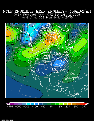
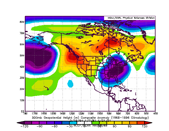
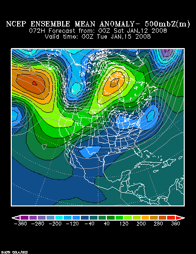
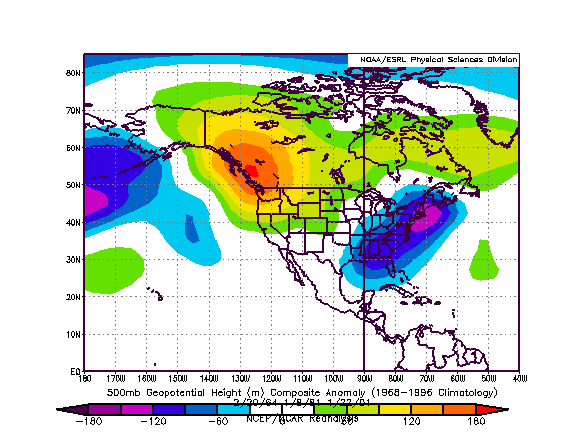
The upper air picture being painted by the NCEP ensemble suite at 48 hours bears some similarity to a composite of February 19, 1964, January 7, 1981, and January 21, 2001, though this time around the system is likely to have substantially more moisture with which to work.

NCEP Ensemble Mean 500 mb Height Anomalies: 48 hours:
Image

Composite Analog for 2/19/1964, 1/7/1981, and 1/21/2001:
Image

NCEP Ensemble Mean 500 mb Height Anomalies: 48 hours:
Image

Composite Analog for 2/19/1964, 1/7/1981, and 1/21/2001:
Image

Two of the three analog cases focused the heavier snows from New York City north and eastward. One focused the heaviest snows in the Philadelphia to New York City area.

At this time, my initial snowfall estimates are as follows:

Albany: 4”-8”
Allentown: 3”-6”
Boston: 7”-14”
Burlington: 3”-6”
Caribou: 1”-3”
Concord: 8”-16”
Hartford: 6”-12”
Harrisburg: 1”-3”
New York City: 3”-6”
Newark: 3”-6”
Philadelphia: 0.5”-1.5”
Portland: 6”-12”
Providence: 4”-8”
White Plains: 4”-8”
Worcester: 7”-14”
0 likes   

donsutherland1
S2K Analyst
S2K Analyst
Posts: 2718
Joined: Mon Sep 15, 2003 8:49 pm
Location: New York

#2 Postby donsutherland1 » Sun Jan 13, 2008 8:16 am

After examining the overnight guidance (0z and 6z), I will make a few adjustments to my initial estimates. I'm not yet sold on the GFS's recent ideas that Providence will be largely rain and will make no changes there. The final figures will be out later this afternoon or early this evening.

Albany: 4”-8”
Allentown: 3”-6”
Boston: 7”-14”
Burlington: 4”-8”
Caribou: 3”-6”
Concord: 8”-16”
Hartford: 7”-14”
Harrisburg: 1”-3”
New York City: 3”-6”
Newark: 3”-6”
Philadelphia: 0.5”-1.5”
Portland: 8”-16”
Providence: 4”-8”
White Plains: 5”-10”
Worcester: 7”-14”
0 likes   

User avatar
Dionne
S2K Supporter
S2K Supporter
Posts: 1616
Age: 74
Joined: Mon Jan 02, 2006 8:51 am
Location: SW Mississippi....Alaska transplant via a Southern Belle.

Re: The January 13-14, 2008 Snowstorm: Initial Thoughts

#3 Postby Dionne » Sun Jan 13, 2008 5:54 pm

Call in all the snowplow drivers!!!!
0 likes   

RL3AO
Moderator-Pro Met
Moderator-Pro Met
Posts: 16308
Joined: Thu Jun 14, 2007 10:03 pm
Location: NC

#4 Postby RL3AO » Sun Jan 13, 2008 6:10 pm

Still a long ways out but the 18z GFS showing an incredible nor'easter at 240 hours.
0 likes   

Ed Mahmoud

Re: The January 13-14, 2008 Snowstorm: Initial Thoughts

#5 Postby Ed Mahmoud » Sun Jan 13, 2008 6:56 pm

18Z WRF (NE US loop from PSU e-Wall) coming closer to JB's thinking, with majority of precip falling with surface temp at/above 36ºF in NYC, suggesting mostly rain depsite favorable 850 mb temps, with only an inch or two after the changeover around 2 or 3 am.

All/mostly snow in BOS, it would appear, near a foot, no school tomorrow.
0 likes   

donsutherland1
S2K Analyst
S2K Analyst
Posts: 2718
Joined: Mon Sep 15, 2003 8:49 pm
Location: New York

#6 Postby donsutherland1 » Sun Jan 13, 2008 7:01 pm

Throughout the day, the 950 mb to surface layers wound up somewhat warmer than were modeled. As a result, I believe it will take longer for the column to cool in such cities as Newark, New York, and Providence. The models have also reduced the qpf in recent runs. Therefore, I have adjusted the snowfall figures down for a number of places. Locations such as Hartford, Worcester, and Boston still appear to be in line for a significant snowfall. However, it should be noted that the GFS also starts Boston as some rain, though any such rain should be very brief there.

My final estimates are as follows:

Albany: 3”-6”
Allentown: 1”-3”
Boston: 7”-14”
Burlington: 3”-6”
Caribou: 3”-6”
Concord: 7”-14”
Hartford: 7”-14”
Harrisburg: 1” or less
New York City: 2”-4”
Newark: 2”-4”
Philadelphia: 1” or less
Portland: 7”-14”
Providence: 3”-7”
White Plains: 4”-8”
Worcester: 7”-14”
0 likes   

Ed Mahmoud

Re:

#7 Postby Ed Mahmoud » Sun Jan 13, 2008 7:28 pm

donsutherland1 wrote:Throughout the day, the 950 mb to surface layers wound up somewhat warmer than were modeled. As a result, I believe it will take longer for the column to cool in such cities as Newark, New York, and Providence. The models have also reduced the qpf in recent runs. Therefore, I have adjusted the snowfall figures down for a number of places. Locations such as Hartford, Worcester, and Boston still appear to be in line for a significant snowfall. However, it should be noted that the GFS also starts Boston as some rain, though any such rain should be very brief there.

My final estimates are as follows:

Albany: 3”-6”
Allentown: 1”-3”
Boston: 7”-14”
Burlington: 3”-6”
Caribou: 3”-6”
Concord: 7”-14”
Hartford: 7”-14”
Harrisburg: 1” or less
New York City: 2”-4”
Newark: 2”-4”
Philadelphia: 1” or less
Portland: 7”-14”
Providence: 3”-7”
White Plains: 4”-8”
Worcester: 7”-14”


Looks like a tragic lack of a snow day for the schoolchildren of St. Martin of Tours in Amityville, NY.
0 likes   

Ed Mahmoud

Re: The January 13-14, 2008 Snowstorm: Initial Thoughts

#8 Postby Ed Mahmoud » Sun Jan 13, 2008 9:34 pm

Not looking good...


The 0Z WRF came in a degree or two warm in ISP and LGA. A degree or two warm, Celcius. 6.7ºC vs predicted 0Z temp of 4.2ºC at LGA. 0Z WRF has NYC changing to snow just after midnight, but starting so far off on the temps, NYC may never change to snow.
0 likes   

donsutherland1
S2K Analyst
S2K Analyst
Posts: 2718
Joined: Mon Sep 15, 2003 8:49 pm
Location: New York

#9 Postby donsutherland1 » Tue Jan 15, 2008 1:27 pm

Verification:

Just 6/15 (40%) of sites verified within the forecast range. 6/9 (67%) of those outside the forecast range had an error of < 1". The average error for such sites was 1.1". New York City, Newark, and White Plains all had errors of 2" or more.

From: 1/12/2008 12:59 pm:
Albany: 4”-8”; Actual: 2.8"; Error: 1.2"
Allentown: 3”-6”; Actual: 0.2"; Error: 2.8"
Boston: 7”-14”; Actual: 7.0"; Within range
Burlington: 3”-6”; Actual: 2.6"; Error: 0.4"
Caribou: 1”-3”; Actual: 5.7"; Error: 2.7"
Concord: 8”-16”; Actual: 10.0"; Within range
Hartford: 6”-12”; Actual: 6.3"; Within range
Harrisburg: 1”-3”; Actual: None; Error: 1.0"
New York City: 3”-6”; Actual: Trace; Error: 3.0"
Newark: 3”-6”; Actual: Trace; Error: 3.0"
Philadelphia: 0.5”-1.5”; Actual: None; Error: 1.0"
Portland: 6”-12”; Actual: 10.5"; Within range
Providence: 4”-8”; Actual: 2.5"; Error: 1.5"
White Plains: 4”-8”; Actual: 1.0"; Error: 3.0"
Worcester: 7”-14”; Actual: 6.2"; Error: 0.8"

From: 1/13/2008 8:13 am:
Albany: 4”-8”; Actual: 2.8"; Error: 1.2"
Allentown: 3”-6”; Actual: 0.2"; Error: 2.8"
Boston: 7”-14”; Actual: 7.0"; Within range
Burlington: 4”-8”; Actual: 2.6"; Error: 1.4"
Caribou: 3”-6”; Actual: 5.7"; Within range
Concord: 8”-16”; Actual: 10.0"; Within range
Hartford: 7”-14”; Actual: 6.3"; Error: 0.7"
Harrisburg: 1”-3”; Actual: None; Error: 1.0"
New York City: 3”-6”; Actual: Trace; Error: 3.0"
Newark: 3”-6”; Actual: Trace; Error: 3.0"
Philadelphia: 0.5”-1.5”; Actual: None; Error: 1.0"
Portland: 8”-16”; Actual: 10.5"; Within range
Providence: 4”-8”; Actual: 2.5"; Error: 1.5"
White Plains: 5”-10”; Actual: 1.0"; Error: 4.0"
Worcester: 7”-14”; Actual: 6.2"; Error: 0.8"

From: 1/13/2008 6:59 pm:
Albany: 3”-6”; Actual: 2.8"; Error: 0.2"
Allentown: 1”-3”; Actual: 0.2"; Error: 0.8"
Boston: 7”-14”; Actual: 7.0"; Within range
Burlington: 3”-6”; Actual: 2.8"; Error: 0.2"
Caribou: 3”-6”; Actual: 5.7"; Within range
Concord: 7”-14”; Actual: 10.0"; Within range
Hartford: 7”-14”; Actual: 6.3"; Error: 0.7"
Harrisburg: 1” or less; Actual: None; Within range
New York City: 2”-4”; Actual: Trace; Error: 2.0"
Newark: 2”-4”; Actual: Trace; Error: 2.0"
Philadelphia: 1” or less; Actual: None; Within range
Portland: 7”-14”; Actual: 10.5"; Within range
Providence: 3”-7”; Actual: 2.5"; Error: 0.5"
White Plains: 4”-8”; Actual: 1.0"; Error: 3.0"
Worcester: 7”-14”; Actual: 6.2"; Error: 0.8"
0 likes   


Return to “Winter Weather”

Who is online

Users browsing this forum: No registered users and 2 guests