Major Southeast Severe Weather Outbreak May 10 and 11th

U.S. & Caribbean Weather Discussions and Severe Weather Events

Moderator: S2k Moderators

Forum rules

The posts in this forum are NOT official forecast and should not be used as such. They are just the opinion of the poster and may or may not be backed by sound meteorological data. They are NOT endorsed by any professional institution or STORM2K.

Help Support Storm2K
Message
Author
6SpeedTA95
Category 5
Category 5
Posts: 1206
Joined: Wed Oct 19, 2005 3:25 pm
Location: Oklahoma
Contact:

Re:

#61 Postby 6SpeedTA95 » Sat May 10, 2008 2:37 pm

RL3AO wrote:That MDT area is huge.

We're about 20 mins away from an update.
0 likes   

User avatar
HarlequinBoy
Category 5
Category 5
Posts: 1400
Age: 34
Joined: Wed Nov 29, 2006 1:57 am
Location: Memphis

#62 Postby HarlequinBoy » Sat May 10, 2008 2:42 pm

I'm not doubting Little Rock because they always do a stellar job, but I do seem some rotation on the Newton County storm.
0 likes   

6SpeedTA95
Category 5
Category 5
Posts: 1206
Joined: Wed Oct 19, 2005 3:25 pm
Location: Oklahoma
Contact:

#63 Postby 6SpeedTA95 » Sat May 10, 2008 2:42 pm

Wow...
http://www.spc.noaa.gov/exper/mesoanaly ... p?sector=3

Check out the cape of 5000+ and LI's of -14 in south central oklahoma :eek:
0 likes   

CrazyC83
Professional-Met
Professional-Met
Posts: 34001
Joined: Tue Mar 07, 2006 11:57 pm
Location: Deep South, for the first time!

Re:

#64 Postby CrazyC83 » Sat May 10, 2008 2:44 pm

6SpeedTA95 wrote:Wow...
http://www.spc.noaa.gov/exper/mesoanaly ... p?sector=3

Check out the cape of 5000+ and LI's of -14 in south central oklahoma :eek:


That's just insane. Any cell there could go into Greensburg territory. It seems initiation is the only limiting factor, that is the only thing IMO that could prevent a high risk from being issued.
Last edited by CrazyC83 on Sat May 10, 2008 2:47 pm, edited 1 time in total.
0 likes   

JonathanBelles
Professional-Met
Professional-Met
Posts: 11430
Age: 34
Joined: Sat Dec 24, 2005 9:00 pm
Location: School: Florida State University (Tallahassee, FL) Home: St. Petersburg, Florida
Contact:

#65 Postby JonathanBelles » Sat May 10, 2008 2:47 pm

Which page are you all looking at?
0 likes   

6SpeedTA95
Category 5
Category 5
Posts: 1206
Joined: Wed Oct 19, 2005 3:25 pm
Location: Oklahoma
Contact:

Re:

#66 Postby 6SpeedTA95 » Sat May 10, 2008 2:52 pm

fact789 wrote:Which page are you all looking at?

Click the link I posted, then click on the thermodynamic fields and then you can choose a host of cape options and the lifted index.
0 likes   

6SpeedTA95
Category 5
Category 5
Posts: 1206
Joined: Wed Oct 19, 2005 3:25 pm
Location: Oklahoma
Contact:

#67 Postby 6SpeedTA95 » Sat May 10, 2008 2:57 pm

The storm due east of mcalester is taking on a decidedly evil look...it looks like its trying to develop some vnotching and rotation.
0 likes   

CrazyC83
Professional-Met
Professional-Met
Posts: 34001
Joined: Tue Mar 07, 2006 11:57 pm
Location: Deep South, for the first time!

#68 Postby CrazyC83 » Sat May 10, 2008 2:58 pm

2000Z: no HIGH, but the MDT expanded north and west
0 likes   

CrazyC83
Professional-Met
Professional-Met
Posts: 34001
Joined: Tue Mar 07, 2006 11:57 pm
Location: Deep South, for the first time!

#69 Postby CrazyC83 » Sat May 10, 2008 3:03 pm

SPC AC 101955

DAY 1 CONVECTIVE OUTLOOK
NWS STORM PREDICTION CENTER NORMAN OK
0255 PM CDT SAT MAY 10 2008

VALID 102000Z - 111200Z

...THERE IS A MDT RISK OF SVR TSTMS FROM ERN OK...NERN TX...SRN
MO...AR...MUCH OF TN...MS...AL AND WRN GA...

...THERE IS A SLGT RISK OF SVR TSTMS FROM PARTS OF THE CNTRL AND SRN
PLAINS THROUGH THE MID-LOWER MS VALLEY...PARTS OF THE OH VALLEY AND
SERN STATES...

...CNRL AND SRN PLAINS THROUGH THE LOWER-MID MS VALLEY AND TN
VALLEY...

QUASISTATIONARY FRONT EXTENDS FROM S SRN SC WWD THROUGH CNTRL GA AND
CNTRL AL WHERE IT TRANSITIONS TO A WARM FRONT FROM CNTRL MS...S
CNTRL AR THEN NWWD TO A SURFACE LOW IN S CNTRL KS. A COLD FRONT
EXTENDS SWWD FROM THE LOW THROUGH NWRN OK AND THE TX PANHANDLE.
DRYLINE FROM NEAR DEL RIO NWD TO NEAR WICHITA FALLS TO SWRN OK IS
MIXING EWD. A LARGE AND UNSTABLE WARM SECTOR EXISTS SOUTH OF THE
WARM FRONT FROM THE SE U.S. LOWER MS VALLEY AND THE SRN PLAINS EAST
OF THE DRYLINE. MID TO UPPER 60S BOUNDARY LAYER DEWPOINTS EXIST
SOUTH OF THE E-W BOUNDARY BENEATH STEEP MID LEVEL LAPSE RATES WITH
MLCAPE FROM 2000 J/KG OVER THE SERN STATES TO 3500 J/KG OVER PARTS
OF ERN TX AND SERN OK AND SW AR.

PRIMARY THUNDERSTORM DEVELOPMENT SO FAR HAS BEEN OVER THE LOWER AND
MID MS VALLEY WITHIN ZONE OF WARM ADVECTION AND ISENTROPIC ASCENT
NORTH OF THE WARM FRONT. THIS ACTIVITY HAS BEEN ELEVATED...BUT
EFFECTIVE SHEAR SUFFICIENT FOR SUPERCELLS...STEEP LAPSE RATES AND
MODERATE MUCAPE ARE SUPPORTING LARGE HAIL WITH THE STRONGER STORMS.
THE 18Z RAOB DATA STILL SHOWED A CAP TO SURFACE BASED STORMS.
HOWEVER...SOME OF THE STORMS DEVELOPING CLOSER TO WARM
FRONT...ESPECIALLY OVER AR AND ERN OK MAY BECOME SURFACE BASED AS
THE BOUNDARY LAYER CONTINUES TO WARM. THE SWLY LOW LEVEL JET WILL
STRENGTHEN IN THIS REGION THROUGH EARLY EVENING WITHIN ZONE OF
HEIGHT FALLS DOWNSTREAM FROM EWD ADVANCING UPPER TROUGH. THIS WILL
MAINTAIN FAVORABLE 0-1 KM HODOGRAPHS FOR SUPERCELLS WITH LOW LEVEL
MESOCYCLONES AND TORNADOES AS STORMS BECOME SURFACE BASED. GIVEN THE
FAVORABLE KINEMATIC AND THERMODYNAMIC ENVIRONMENT...ANY DISCRETE
STORMS WILL HAVE POTENTIAL TO PRODUCE STRONG TORNADOES. OTHER STORMS
MAY DEVELOP ALONG AND AHEAD OF THE DRYLINE AS IT MIXING EAST INTO
ERN OK INTO N CNTRL AND NERN TX. SUPERCELLS WITH VERY LARGE HAIL AND
A FEW TORNADOES WILL BE POSSIBLE.

STORMS WILL LIKELY INCREASE IN COVERAGE OVERNIGHT AS THE COLD FRONT
OVERTAKES THE DRYLINE. ACTIVITY WILL LIKELY EVOLVE INTO ONE MORE
MCSS AND CONTINUE EAST THROUGH THE LOWER MS VALLEY...TN VALLEY AND
SERN STATES. THE STRENGTHENING AND VEERING LOW LEVEL JET AND
FAVORABLE DEEP SHEAR WILL SUPPORT EMBEDDED ORGANIZED STORMS
INCLUDING SUPERCELL AND LEWP STRUCTURES. PRIMARY THREAT IS EXPECTED
TO TRANSITION TO WIDESPREAD DAMAGING WIND OVERNIGHT...BUT ISOLATED
LARGE HAIL AND TORNADOES WILL REMAIN POSSIBLE.


...CNTRL AND ERN GULF COAST STATES...

A FEW STORMS HAVE DEVELOPED ALONG THE E-W BOUNDARY ACROSS GA AND
OTHER STORMS WILL LIKELY DEVELOP FARTHER WEST ACROSS AL AND MS AS
THE CAP WEAKENS THIS AFTERNOON AND EVENING. THE 0-1 KM HODOGRAPHS
ARE NOT PARTICULARLY LARGE IN THIS REGION DUE TO THE LOW LEVEL JET
REMAINING WEST THIS AFTERNOON. HOWEVER...DEEP LAYER SHEAR OF 40-50
KT IS SUPPORTIVE OF SUPERCELL STRUCTURES. INITIAL PRIMARY THREATS
WILL BE LARGE HAIL...BUT PRESENCE OF VERTICAL VORTICITY ALONG THE
BOUNDARY SUGGEST ISOLATED TORNADOES CANNOT BE RULED OUT. LOW LEVEL
HELICITY WILL INCREASE FROM W-E ALONG THE BOUNDARY DURING THE
EVENING AS THE UPPER TROUGH AND ATTENDANT LOW LEVEL JET ADVANCE
EAST. THIS WILL POSE AN INCREASING THREAT FOR ISOLATED TORNADOES AND
DAMAGING WIND INTO THE EVENING.

..DIAL.. 05/10/2008

CLICK TO GET WUUS01 PTSDY1 PRODUCT

NOTE: THE NEXT DAY 1 OUTLOOK IS SCHEDULED BY 0100Z
CURRENT UTC TIME: 2002Z (4:02PM), RELOAD THIS PAGE TO UPDATE THE TIME
0 likes   

6SpeedTA95
Category 5
Category 5
Posts: 1206
Joined: Wed Oct 19, 2005 3:25 pm
Location: Oklahoma
Contact:

#70 Postby 6SpeedTA95 » Sat May 10, 2008 3:04 pm

wtfgraphic on the convective update
0 likes   

User avatar
HarlequinBoy
Category 5
Category 5
Posts: 1400
Age: 34
Joined: Wed Nov 29, 2006 1:57 am
Location: Memphis

#71 Postby HarlequinBoy » Sat May 10, 2008 3:04 pm

The entire state of Arkansas is in the Tornado hatched, along with southern MO, west TN, 2/3 of MS, east OK, ne TX, and NW Alabama.
0 likes   

User avatar
HarlequinBoy
Category 5
Category 5
Posts: 1400
Age: 34
Joined: Wed Nov 29, 2006 1:57 am
Location: Memphis

Re:

#72 Postby HarlequinBoy » Sat May 10, 2008 3:05 pm

6SpeedTA95 wrote:wtfgraphic on the convective update


Yeah, I saw that. Weird.
0 likes   

6SpeedTA95
Category 5
Category 5
Posts: 1206
Joined: Wed Oct 19, 2005 3:25 pm
Location: Oklahoma
Contact:

#73 Postby 6SpeedTA95 » Sat May 10, 2008 3:05 pm

Tornadic threat shifted decidedly west :eek:
0 likes   

Ed Mahmoud

Re: Major Southeast Severe Weather Outbreak May 10 and 11th

#74 Postby Ed Mahmoud » Sat May 10, 2008 3:06 pm

88ºF (31ºC) near Crawford, TX, where sometime today Jenna Bush is getting married. I hope the dime sized hail last night provided some excitement at the Bush ranch, but imagine what stories former President George W Bush can tell his grand-children if baseball sized hail falls at his daughter's wedding. Possible, as the dryline hasn't passed yet, as the dewpoint is still 72ºF (22º).


Radar suggests the dryline is still about an hour or two from Crawford.


RUC forecast suggests cap when dryline passes will probably be too strong for thunderstorm development, and low level winds will be a tad weak, and cloud bases a bit too high for tornadoes even if a storm can develop, but very steep mid-level lapse rates and strong speed shear in the area of greatest instability means damaging downburst winds and large hail would be a possibility.

Image


My unofficial estimate, only a 15% chance of a storm at the ranch, but a 90% chance of severe wind or hail if one can bust the cap.
0 likes   

6SpeedTA95
Category 5
Category 5
Posts: 1206
Joined: Wed Oct 19, 2005 3:25 pm
Location: Oklahoma
Contact:

#75 Postby 6SpeedTA95 » Sat May 10, 2008 3:07 pm

Anyone else seeing this goofy POS as their main conv page?
Image
0 likes   

User avatar
HarlequinBoy
Category 5
Category 5
Posts: 1400
Age: 34
Joined: Wed Nov 29, 2006 1:57 am
Location: Memphis

Re:

#76 Postby HarlequinBoy » Sat May 10, 2008 3:10 pm

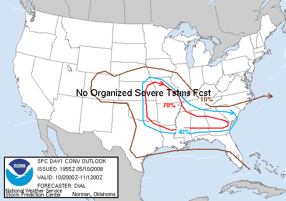
6SpeedTA95 wrote:Tornadic threat shifted decidedly west :eek:


Yeah, a bit. Mostly it looks like they took out the eastward extension into AL/GA.

Image

Shreveport, Little Rock, Memphis, Huntsville, Jackson MS and TN, Birmingham and Tulsa!
Last edited by HarlequinBoy on Sat May 10, 2008 3:13 pm, edited 1 time in total.
0 likes   

6SpeedTA95
Category 5
Category 5
Posts: 1206
Joined: Wed Oct 19, 2005 3:25 pm
Location: Oklahoma
Contact:

#77 Postby 6SpeedTA95 » Sat May 10, 2008 3:11 pm

MDT has been expanded west that makes sense based on all the data that came out about noon.
0 likes   

Ed Mahmoud

Re:

#78 Postby Ed Mahmoud » Sat May 10, 2008 3:12 pm

6SpeedTA95 wrote:Anyone else seeing this goofy POS as their main conv page?
Image


yes.
0 likes   

6SpeedTA95
Category 5
Category 5
Posts: 1206
Joined: Wed Oct 19, 2005 3:25 pm
Location: Oklahoma
Contact:

Re: Re:

#79 Postby 6SpeedTA95 » Sat May 10, 2008 3:12 pm

Ed Mahmoud wrote:
6SpeedTA95 wrote:Anyone else seeing this goofy POS as their main conv page?
Image


yes.

Someone got in a hurry lol
0 likes   

6SpeedTA95
Category 5
Category 5
Posts: 1206
Joined: Wed Oct 19, 2005 3:25 pm
Location: Oklahoma
Contact:

#80 Postby 6SpeedTA95 » Sat May 10, 2008 3:27 pm

Storm going up fast over arkansas city kansas
0 likes   


Return to “USA & Caribbean Weather”

Who is online

Users browsing this forum: No registered users and 76 guests