
HURAKAN wrote::uarrow: That would be really interesting!!!
Scary too...if 2 storms enter the gulf!
Moderator: S2k Moderators

HURAKAN wrote::uarrow: That would be really interesting!!!
lebron23 wrote:


gatorcane wrote:I'm with Derek here, I'm starting to doubt the global models with this Western Caribbean system. An EPAC system weakening over Central America with some remnant moisture streaming north into the GOM is more likely IMHO.

NDG wrote:Talking about phantom storms, I am surprised nobody has noticed the phantom super storm that the euro has been coming out with since last week in the Arabian Sea, it keeps putting development off for day seven of its forecast, with nothing panning out yet, now that's what I call a flaw.

boca wrote:I do see a little rotation in the clouds in the SW Caribbean.
http://www.ssd.noaa.gov/goes/east/watl/avn-l.jpg


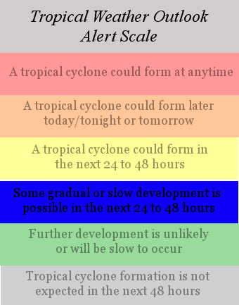
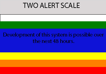
Cyclone1 wrote:RL3AO wrote:TWO Alert scale v2.0.
Like or dislike?
I like it.

Users browsing this forum: No registered users and 178 guests


