TC Bertha
Moderator: S2k Moderators
-
Ed Mahmoud
Re:
Derek Ortt wrote:but 1997's 2 July hurricanes did not come from tropical waves
Future Hurricane Danny produced quite an impressive lightning show when it passed over my apartment in Lafayette, LA on its way to the Gulf. Local TV met Rob Perillo called that one as a possible tropical cyclone candidate the very next day.
0 likes

It looks like that Bertha is finally getting influenced by the Bermuda ridge as the weakness to her north keeps pushing east, it looks as if she has gone back to a WNW track the last couple of hours. Bermuda may not be out of the woods just yet if she is indeed going back on a WNW track for at least a day.
0 likes
-
Gustywind

- Category 5

- Posts: 12334
- Joined: Mon Sep 03, 2007 7:29 am
- Location: Baie-Mahault, GUADELOUPE
Re:
Derek Ortt wrote:1989 had a small storm that went by the name of Hugo
Small why small Derek?

Hope that won't forget that this small storm was second disaster in Guadeloupe after the enormous cane of 1928:eek:.
So we can't forget this small storm it's inked in ours live in Guadeloupe for sure, and the nightmare for most of the residents of the Leewards including Puerto Rico etc...
0 likes
Re: Re:
Ed Mahmoud wrote:Derek Ortt wrote:July Cape Verde TCs usually mean an active CV season
Just look at 1989 and 1996 as examples
Dr. Gene Norman, the MIT educated replacement for Dr. Neil Frank on KHOU-TV 11, said last night that his analysis of years with July hurricanes since 1995 indicate an average of almost 16 named storms in a season, and considering what a dud 1997 turned out to be after a busy June and July, the rest of those seasons must have been impressive.
"Since 1995" way to small a sample size to make any coorelations. 97 was a dud, but 05 was just as much an anomoly.
0 likes
-
Category 5

- Category 5
- Posts: 10074
- Age: 36
- Joined: Sun Feb 11, 2007 10:00 pm
- Location: New Brunswick, NJ
- Contact:
Re: Re:
Gustywind wrote:Derek Ortt wrote:1989 had a small storm that went by the name of Hugo
Small why small Derek?explain please

Hope that won't forget that this small storm was second disaster in Guadeloupe after the enormous cane of 1928:eek:.
So we can't forget this small storm it's inked in ours live in Guadeloupe for sure, and the nightmare for most of the residents of the Leewards including Puerto Rico etc...
He was being sarcastic. I'm sure Derek knows how devastating it was as do we all.
Last edited by Category 5 on Tue Jul 08, 2008 1:09 pm, edited 1 time in total.
0 likes
-
Ed Mahmoud
Re: Hurricane Bertha in Central Atlantic
The NOAA Nesdis SSD floater won't update past 0945Z.
0 likes
-
storms in NC

- S2K Supporter

- Posts: 2338
- Joined: Thu Jul 28, 2005 2:58 pm
- Location: Wallace,NC 40 miles NE of Wilm
- Contact:
wow. She is still out there and every one leaves. I readed the late 2 pages and it sounded like a funeral. It is still a Storm and any thing can happen. It maybe out in the sea doing it's thing but I don;t think she is done till she is gone ,poof ,Nada nothing. I guess cause it is out to sea no one cares.
If you go back to my post on Sat I think. I was the only one who called it to go to the right of Bermuda. Yes I was wishcastting for the rain. But I never changed from Bermuda. maybe we can get a home grown TD would be nice here.
It rained here and got 1/10 of a inch
The waters here a very warm here so any thing can't happen.
0 likes
-
micktooth

- S2K Supporter
- Posts: 391
- Joined: Mon Jul 11, 2005 3:47 pm
- Location: PreK:New Orleans,PostK:Colorado
Re:
Fego wrote:A just saw (again) GLADIATOR with Russell Crowe, and it ocurred to me this: !Bertha!, we the ones who celebrate your birth, say goodbye!
"Are you not entertained!?"
Bertha is still very interesting, I'm not sure why so many people have abandoned ship. Could they be "closet people I disagree with"?
0 likes

Re:
NDG wrote:It looks like that Bertha is finally getting influenced by the Bermuda ridge as the weakness to her north keeps pushing east, it looks as if she has gone back to a WNW track the last couple of hours. Bermuda may not be out of the woods just yet if she is indeed going back on a WNW track for at least a day.
Looks that way to me too. I also wondered whether this interaction with the ridge contributed significantly to Bertha's disorganization today.
0 likes
-
Fego

- S2K Supporter
- Posts: 767
- Age: 66
- Joined: Sun Apr 18, 2004 7:58 pm
- Location: San Juan, Puerto Rico
- Contact:
Re: Re:
micktooth wrote:Fego wrote:A just saw (again) GLADIATOR with Russell Crowe, and it ocurred to me this: !Bertha!, we the ones who celebrate your birth, say goodbye!
"Are you not entertained!?"
Bertha is still very interesting, I'm not sure why so many people have abandoned ship. Could they be "closet people I disagree with"?
As a matter of fact, I'm in the ship. If I wish goodbye that doesn't mean that I'm not following 'her' development, etc. If somebody says that Bertha will hit some city, or in the contrary, that won't hit a mass land, you can be sure I won't jump into it arguing about motivations.
0 likes
-
cycloneye

- Admin

- Posts: 149291
- Age: 69
- Joined: Thu Oct 10, 2002 10:54 am
- Location: San Juan, Puerto Rico
Re: Hurricane Bertha in Central Atlantic
Down to 75 kts per ATCF:
AL, 02, 2008070818, , BEST, 0, 224N, 544W, 75, 980, HU, 64, NEQ, 25, 15, 15, 15, 1016, 200, 15, 0, 0,
AL, 02, 2008070818, , BEST, 0, 224N, 544W, 75, 980, HU, 64, NEQ, 25, 15, 15, 15, 1016, 200, 15, 0, 0,
0 likes
-
tolakram
- Admin
- Posts: 20179
- Age: 62
- Joined: Sun Aug 27, 2006 8:23 pm
- Location: Florence, KY (name is Mark)
Re: Hurricane Bertha in Central Atlantic
The floaters accessed from the NHC page aren't updating.
http://rammb.cira.colostate.edu/products/tc_realtime/
This page is though.
Latest infrared shows some increase convection. Still looks to be under a ton of shear.
If it can survive then more heat content in 24 hours or so.

http://rammb.cira.colostate.edu/products/tc_realtime/
This page is though.
Latest infrared shows some increase convection. Still looks to be under a ton of shear.
If it can survive then more heat content in 24 hours or so.
Last edited by tolakram on Tue Jul 08, 2008 1:44 pm, edited 1 time in total.
0 likes


-
alan1961

- Category 2

- Posts: 771
- Joined: Mon Mar 20, 2006 11:58 am
- Location: Derby, Derbyshire, England
- Contact:
Re: Hurricane Bertha in Central Atlantic
not sure wether i'm seeing things but is the centre trying to pull a little west than the projected path?
0 likes
-
OuterBanker
- S2K Supporter
- Posts: 1761
- Joined: Wed Feb 26, 2003 10:53 am
- Location: Nags Head, NC
- Contact:
-
PTrackerLA

- Category 5
- Posts: 5281
- Age: 42
- Joined: Thu Oct 10, 2002 8:40 pm
- Location: Lafayette, LA
Re: Re:
Ed Mahmoud wrote:Derek Ortt wrote:but 1997's 2 July hurricanes did not come from tropical waves
Future Hurricane Danny produced quite an impressive lightning show when it passed over my apartment in Lafayette, LA on its way to the Gulf. Local TV met Rob Perillo called that one as a possible tropical cyclone candidate the very next day.
I remember that MCS/squall line very well. I believe it stretched from near New Orleans all the way to Lake Charles as it pushed south with tons of lightning and very strong winds...one of the most impressive squall line events I've ever seen. It never died out as it pushed into the gulf and by the next evening there was a circulation developing. Neat to know you remember it as well! I'm pretty sure Alicia formed in a similar manner. A truly memorable event and I don't think we've had a "home-grown" like that since.
0 likes
-
tolakram
- Admin
- Posts: 20179
- Age: 62
- Joined: Sun Aug 27, 2006 8:23 pm
- Location: Florence, KY (name is Mark)
Re: Hurricane Bertha in Central Atlantic

The posts in this forum are NOT official forecast and should not be used as such. They are just the opinion of the poster and may or may not be backed by sound meteorological data. They are NOT endorsed by any professional institution or storm2k.org. For official information, please refer to the NHC and NWS products.
Shear may be dropping rapidly. I'm looking for signs of intensification again.
You know a button to add the disclaimer, or the disclaimer text showing somewhere on the Post a reply page would be helpful.
0 likes
-
srainhoutx

- S2K Supporter
- Posts: 6919
- Age: 68
- Joined: Sun Jan 14, 2007 11:34 am
- Location: Haywood County, NC
- Contact:
Re: Re:
PTrackerLA wrote:Ed Mahmoud wrote:Derek Ortt wrote:but 1997's 2 July hurricanes did not come from tropical waves
Future Hurricane Danny produced quite an impressive lightning show when it passed over my apartment in Lafayette, LA on its way to the Gulf. Local TV met Rob Perillo called that one as a possible tropical cyclone candidate the very next day.
I remember that MCS/squall line very well. I believe it stretched from near New Orleans all the way to Lake Charles as it pushed south with tons of lightning and very strong winds...one of the most impressive squall line events I've ever seen. It never died out as it pushed into the gulf and by the next evening there was a circulation developing. Neat to know you remember it as well! I'm pretty sure Alicia formed in a similar manner. A truly memorable event and I don't think we've had a "home-grown" like that since.
You are correct. Alicia caught many by surprise.
http://www.nhc.noaa.gov/archive/storm_w ... elim01.gif
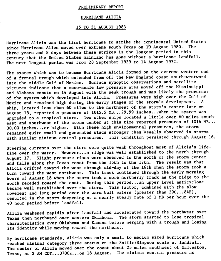
http://www.nhc.noaa.gov/archive/storm_w ... elim02.gif
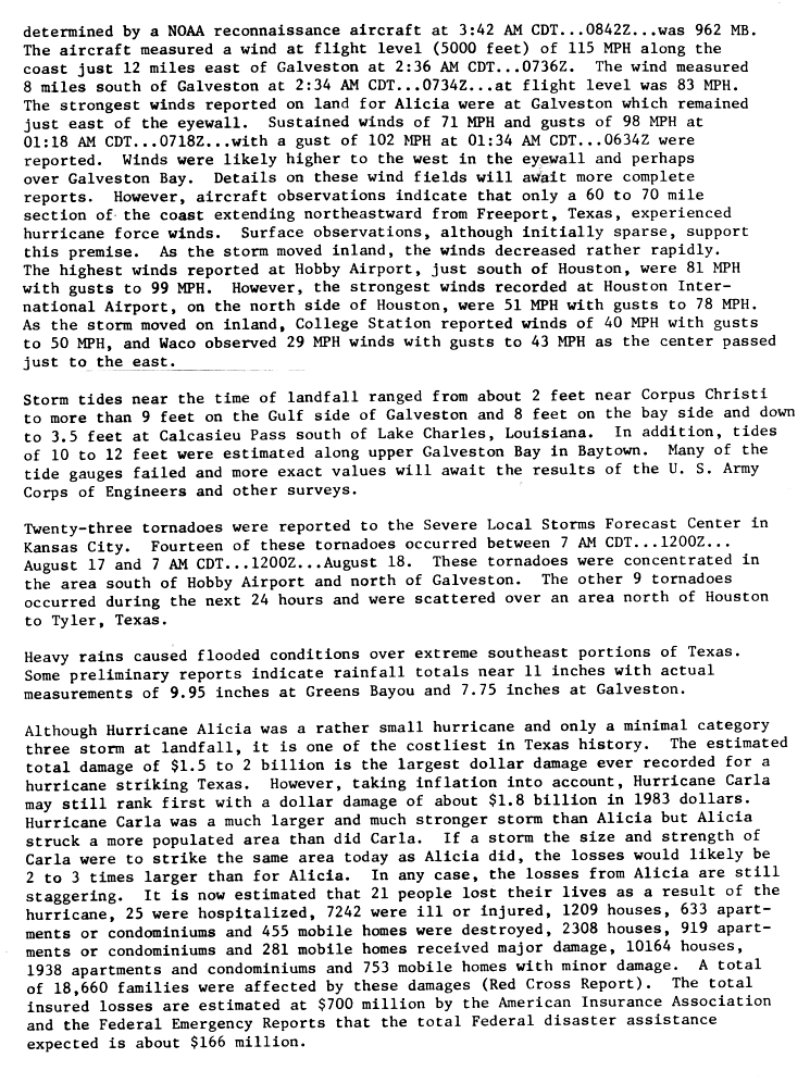
Last edited by srainhoutx on Tue Jul 08, 2008 2:16 pm, edited 1 time in total.
0 likes
Who is online
Users browsing this forum: No registered users and 12 guests