TC Bertha

Moderator: S2k Moderators

Message
Author
User avatar
HURAKAN
Professional-Met
Professional-Met
Posts: 46086
Age: 38
Joined: Thu May 20, 2004 4:34 pm
Location: Key West, FL
Contact:

Re: Hurricane Bertha in Central Atlantic

#3301 Postby HURAKAN » Wed Jul 09, 2008 4:12 pm

Image

Image

Beautiful storm.
0 likes   

jaxfladude
Category 5
Category 5
Posts: 1249
Joined: Wed Aug 24, 2005 9:36 pm
Location: Jacksonville, Fla

Re: Hurricane Bertha in Central Atlantic

#3302 Postby jaxfladude » Wed Jul 09, 2008 4:13 pm

We all should take Bertha as an omen(good/bad) for the rest of the season....
I hope that all CV-type storms take same track(or similar) and out to sea w/o any landmass/island(s) getting hit head on......(no loops allowed Bertha!).
0 likes   

CrazyC83
Professional-Met
Professional-Met
Posts: 34002
Joined: Tue Mar 07, 2006 11:57 pm
Location: Deep South, for the first time!

Re: Hurricane Bertha in Central Atlantic

#3303 Postby CrazyC83 » Wed Jul 09, 2008 4:20 pm

Category 5 wrote:CrazyC83 hit it on the head, it gained it's intensity back.


If shear returns, I see quick weakening again. Small storms are notorious for rapid fluctuations.
0 likes   

User avatar
KWT
Category 5
Category 5
Posts: 31415
Joined: Tue Aug 17, 2004 11:02 am
Location: UK!!!

#3304 Postby KWT » Wed Jul 09, 2008 4:24 pm

Certainly is Hurakan looks like a major hurricane, nice looking eye and also the hurricane has grown in size a little bit since 18hrs ago.

Also hasn't got quite as strong as it did the first time round according to the T numbers but its still a major according to that.
0 likes   

User avatar
HURAKAN
Professional-Met
Professional-Met
Posts: 46086
Age: 38
Joined: Thu May 20, 2004 4:34 pm
Location: Key West, FL
Contact:

Re: Hurricane Bertha in Central Atlantic

#3305 Postby HURAKAN » Wed Jul 09, 2008 4:27 pm

Image

Image

Image

All you see in just 48 hours!!!
0 likes   

HurricaneHunter914
Category 5
Category 5
Posts: 4439
Age: 31
Joined: Fri Mar 10, 2006 7:36 pm
Location: College Station, TX

#3306 Postby HurricaneHunter914 » Wed Jul 09, 2008 4:31 pm

Wow that is just crazy! :eek: I agree, she looked better 2 days ago, but is still beautiful.
0 likes   

User avatar
Hurricanewatcher2007
Category 2
Category 2
Posts: 578
Joined: Sat Jul 05, 2008 8:10 pm

Re: Hurricane Bertha in Central Atlantic

#3307 Postby Hurricanewatcher2007 » Wed Jul 09, 2008 4:38 pm

UW - CIMSS
ADVANCED DVORAK TECHNIQUE
ADT-Version 7.2.3
Tropical Cyclone Intensity Algorithm

----- Current Analysis -----
Date : 09 JUL 2008 Time : 204500 UTC
Lat : 24:55:32 N Lon : 58:07:43 W


CI# /Pressure/ Vmax
5.4 / 961.8mb/ 99.6kt


Final T# Adj T# Raw T#
(3hr avg)
5.4 5.4 5.4

Latitude bias adjustment to MSLP : -0.2mb

Estimated radius of max. wind based on IR : 16 km

Center Temp : +4.2C Cloud Region Temp : -56.2C

Scene Type : EYE

Positioning Method : RING/SPIRAL COMBINATION

Ocean Basin : ATLANTIC
Dvorak CI > MSLP Conversion Used : ATLANTIC

Tno/CI Rules : Constraint Limits : NO LIMIT
Weakening Flag : OFF
Rapid Dissipation Flag : OFF

****************************************************
0 likes   

User avatar
cycloneye
Admin
Admin
Posts: 145313
Age: 68
Joined: Thu Oct 10, 2002 10:54 am
Location: San Juan, Puerto Rico

Re: Hurricane Bertha in Central Atlantic

#3308 Postby cycloneye » Wed Jul 09, 2008 4:40 pm

:uarrow: Cat 3 in the next advisory.
0 likes   

User avatar
HURAKAN
Professional-Met
Professional-Met
Posts: 46086
Age: 38
Joined: Thu May 20, 2004 4:34 pm
Location: Key West, FL
Contact:

#3309 Postby HURAKAN » Wed Jul 09, 2008 4:51 pm

5.5

2008JUL09 204500 5.5 959.8/ -0.2 /102.0 5.5 5.7 5.8 2.2T/6hr OFF OFF 4.24 -56.23 EYE 16 IR 24.93 58.13 COMBO 62.7
0 likes   

User avatar
storms in NC
S2K Supporter
S2K Supporter
Posts: 2338
Joined: Thu Jul 28, 2005 2:58 pm
Location: Wallace,NC 40 miles NE of Wilm
Contact:

Re: Hurricane Bertha in Central Atlantic

#3310 Postby storms in NC » Wed Jul 09, 2008 4:51 pm

I am old school here. now look at this map and tell me Why would a Low go to a High. It don't make sense to me. Not when I have been told a low will go to a low but not a High. So what is up with this? From the look of this map a stall would be coming very shortly if not a turn to the west or east. But not straight up to the high. Okay pros Please help a old lady here.

[img]Image[/img]
Last edited by storms in NC on Wed Jul 09, 2008 4:53 pm, edited 1 time in total.
0 likes   

User avatar
HURAKAN
Professional-Met
Professional-Met
Posts: 46086
Age: 38
Joined: Thu May 20, 2004 4:34 pm
Location: Key West, FL
Contact:

Re: Hurricane Bertha in Central Atlantic

#3311 Postby HURAKAN » Wed Jul 09, 2008 4:53 pm

Going up really fast:

2008JUL09 171500 3.8 989.7/ -0.1 / 61.0 3.8 4.1 5.9 0.5T/hour OFF OFF -1.46 -58.87 EYE 16 IR 24.46 57.66 COMBO 0.0
2008JUL09 174500 4.1 985.3/ -0.1 / 67.4 4.1 5.4 6.0 2.2T/6hr OFF OFF 8.54 -58.60 EYE 16 IR 24.51 57.72 COMBO 0.0
2008JUL09 181500 4.4 980.5/ -0.1 / 74.6 4.4 5.4 5.9 2.2T/6hr OFF OFF 6.74 -58.00 EYE 16 IR 24.66 57.78 COMBO 62.7
2008JUL09 184500 4.5 978.9/ -0.1 / 77.0 4.5 5.4 5.9 2.2T/6hr OFF OFF 11.84 -57.63 EYE 18 IR 24.70 57.84 COMBO 62.7
2008JUL09 191500 4.8 973.5/ -0.1 / 84.8 4.8 5.5 5.9 2.2T/6hr OFF OFF 8.14 -57.66 EYE 17 IR 24.73 57.90 COMBO 62.7
2008JUL09 194500 5.0 969.8/ -0.2 / 90.0 5.0 5.6 5.8 2.2T/6hr OFF OFF 7.04 -57.54 EYE 17 IR 24.86 57.96 COMBO 62.7
2008JUL09 201500 5.2 965.8/ -0.2 / 94.8 5.2 5.6 5.8 2.2T/6hr OFF OFF 6.44 -56.71 EYE 18 IR 24.88 58.08 COMBO 62.7
2008JUL09 204500 5.5 959.8/ -0.2 /102.0 5.5 5.7 5.8 2.2T/6hr OFF OFF 4.24 -56.23 EYE 16 IR 24.93 58.13 COMBO 62.7

From 1715 to 2045 the CI numbers have increased from 3.8 to 5.5. That's 1.7 / 3.5 hrs = 0.49 per hour!!
0 likes   

User avatar
wxman57
Moderator-Pro Met
Moderator-Pro Met
Posts: 22978
Age: 67
Joined: Sat Jun 21, 2003 8:06 pm
Location: Houston, TX (southwest)

Re: Hurricane Bertha in Central Atlantic

#3312 Postby wxman57 » Wed Jul 09, 2008 4:54 pm

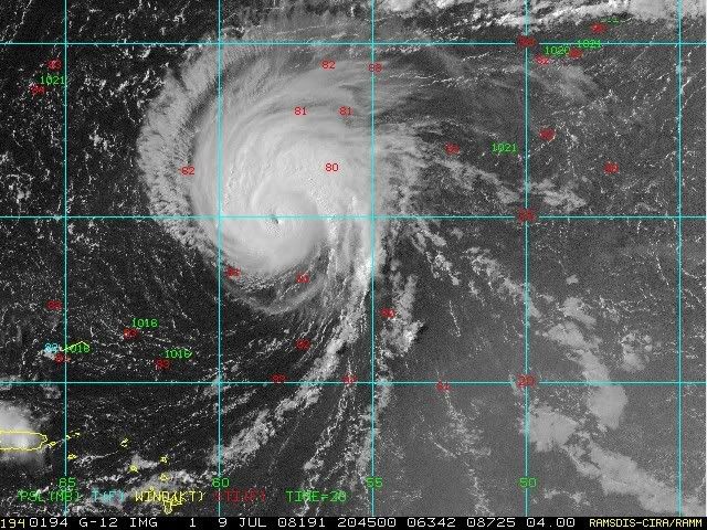
storms in NC wrote:I am old school here. now look at this map and tell me Why would a Low go to a High. It doesn't make sense to me. Not when I have been told a low will go to a low but not a High. So what is up this this. From the look of this map a stall would be coming very shortly if not a turn to the west or east. But not straight up to the high. Okay pros Please help a old lady here.

Image


You're making the assumption that the high is stationary. It's not. The high center is forecast to retreat to the N-NNE over the next few days with Bertha rotating around the western side of the high.
0 likes   

jaxfladude
Category 5
Category 5
Posts: 1249
Joined: Wed Aug 24, 2005 9:36 pm
Location: Jacksonville, Fla

Re: Hurricane Bertha in Central Atlantic

#3313 Postby jaxfladude » Wed Jul 09, 2008 4:54 pm

How Bertha got her groove back.... :cheesy:
0 likes   

User avatar
KWT
Category 5
Category 5
Posts: 31415
Joined: Tue Aug 17, 2004 11:02 am
Location: UK!!!

#3314 Postby KWT » Wed Jul 09, 2008 5:01 pm

Looking very likely Bertha will indeed be upgraded to a major hurricane again, very impressive stuff have to admit for so early in the season!
0 likes   

User avatar
HURAKAN
Professional-Met
Professional-Met
Posts: 46086
Age: 38
Joined: Thu May 20, 2004 4:34 pm
Location: Key West, FL
Contact:

#3315 Postby HURAKAN » Wed Jul 09, 2008 5:02 pm

48 Hours Ago:

Image

Now:

Image
0 likes   

User avatar
wxman57
Moderator-Pro Met
Moderator-Pro Met
Posts: 22978
Age: 67
Joined: Sat Jun 21, 2003 8:06 pm
Location: Houston, TX (southwest)

Re: Hurricane Bertha in Central Atlantic

#3316 Postby wxman57 » Wed Jul 09, 2008 5:03 pm

Derek, check out the latest satellite imagery. Does it look like Bertha is showing signs of entering an ERC?
0 likes   

Derek Ortt

#3317 Postby Derek Ortt » Wed Jul 09, 2008 5:13 pm

I cannot tell from the IR, and we don't have a recent microwave

From the pass earlier today and the WV imagery... the southern side is set up prime to trigger an EWRC with the dry air very near the core. This should confine the rainbands on that side. However, the northern side does not seem as favorable and there is a greater moisture envelope and a weaker moisture gradient. In fact, the rainbands do not seem to ahve the circularity there to allow for an EWRC

what may be happening is this is getting near its MPI
0 likes   

Derek Ortt

#3318 Postby Derek Ortt » Wed Jul 09, 2008 5:17 pm

I'd feel more confident of an EWRC is this was headed west instead of north
0 likes   

User avatar
KWT
Category 5
Category 5
Posts: 31415
Joined: Tue Aug 17, 2004 11:02 am
Location: UK!!!

#3319 Postby KWT » Wed Jul 09, 2008 5:24 pm

Very interesting, so even if Bertha wanted to Derek it probably couldn't get much stronger, impressive for a system to get close to its MPI, wouldn't surprise me if that was the case given its early July and we do have likely a major hurricane on our hands again!
0 likes   

User avatar
wxman57
Moderator-Pro Met
Moderator-Pro Met
Posts: 22978
Age: 67
Joined: Sat Jun 21, 2003 8:06 pm
Location: Houston, TX (southwest)

Re:

#3320 Postby wxman57 » Wed Jul 09, 2008 5:25 pm

Derek Ortt wrote:I'd feel more confident of an EWRC is this was headed west instead of north


This IR image caught my eye (so to speak). Note the dark ring forming around the eyewall (a moat?):
Image
Last edited by wxman57 on Wed Jul 09, 2008 5:27 pm, edited 1 time in total.
0 likes   


Return to “2008”

Who is online

Users browsing this forum: No registered users and 0 guests