Well Defined Wave off African Coast

This is the general tropical discussion area. Anyone can take their shot at predicting a storms path.

Moderator: S2k Moderators

Forum rules

The posts in this forum are NOT official forecasts and should not be used as such. They are just the opinion of the poster and may or may not be backed by sound meteorological data. They are NOT endorsed by any professional institution or STORM2K. For official information, please refer to products from the National Hurricane Center and National Weather Service.

Help Support Storm2K
Message
Author
User avatar
HURAKAN
Professional-Met
Professional-Met
Posts: 46086
Age: 38
Joined: Thu May 20, 2004 4:34 pm
Location: Key West, FL
Contact:

Re:

#241 Postby HURAKAN » Mon Jul 21, 2008 8:08 pm

fci wrote:How about those areas behind this one??


Lets first deal with the first one!!! :lol: :lol: :lol: :lol:
0 likes   

User avatar
NONAME
Category 1
Category 1
Posts: 373
Age: 35
Joined: Sat Mar 18, 2006 8:15 am
Location: Where the Wind Blows

Re: Well Defined Wave about to emerge Africa

#242 Postby NONAME » Mon Jul 21, 2008 8:10 pm

Mecklenburg wrote:hello, can somebody give me a link to the GFDL model website? thnx...


The GFDL Doesn't run till it is an invest but here is a website that has the GFDL look here when/if it becomes an invest.

http://moe.met.fsu.edu/tcgengifs/
0 likes   

User avatar
cycloneye
Admin
Admin
Posts: 145300
Age: 68
Joined: Thu Oct 10, 2002 10:54 am
Location: San Juan, Puerto Rico

Re: Well Defined Wave off African Coast

#243 Postby cycloneye » Mon Jul 21, 2008 8:20 pm

Now that the wave and the low pressure are off the African coast,the question is,when they will put a invest tag to it if that occurs at all.
0 likes   

User avatar
SouthFloridawx
S2K Supporter
S2K Supporter
Posts: 8346
Age: 46
Joined: Tue Jul 26, 2005 1:16 am
Location: Sarasota, FL
Contact:

Re: Well Defined Wave off African Coast

#244 Postby SouthFloridawx » Mon Jul 21, 2008 8:22 pm

Well... I was looking at this thing. Besides the 12Z GFS, CMC, NGPS and UKMET develop this thing, but not very intense. The fact that it's moving over cooler waters... I don't think it's gonna develop with a bang. The 18Z GFS doesn't develop it, and there is more upper level divergence to the south. I'm not saying it won't develop down the road... I'm just not sure yet. We'll see I guess...

What's it got going for it? I know it's got a circulation but, without low level convergence...

Upper Level Divergence
Image

Cyclone Phase Map
http://moe.met.fsu.edu/cyclonephase/gfs/fcst/index.html

CMC
Image
GFS
Image
NGP
Image
UKMET
Image

Image

Image
0 likes   

User avatar
cycloneye
Admin
Admin
Posts: 145300
Age: 68
Joined: Thu Oct 10, 2002 10:54 am
Location: San Juan, Puerto Rico

Re: Well Defined Wave off African Coast

#245 Postby cycloneye » Mon Jul 21, 2008 8:34 pm

I didnt see the 8 PM discussion posted so here it is about the wave added to the surface analysis: The low at 17n,wow way too north as cooler waters and more drier conditions are in that latitud.

STRONG TROPICAL WAVE HAS BEEN ADDED TO THE 21/1800 UTC SURFACE
ANALYSIS AND IS ALONG 17W S OF 20N MOVING W NEAR 15-20 KT. A
1007 MB LOW IS ANALYZED ALONG THE AXIS NEAR 17N. WAVE EXHIBITS A
GOOD DEAL OF BROAD CYCLONIC TURNING AS IT IS EMERGING OFF AFRICA
AND INTO THE OPEN WATERS OF THE ERN ATLANTIC. NO ORGANIZED DEEP
CONVECTION IS NORTH OF THE ANALYZED LOW WITH ONLY SCATTERED
SHOWERS WITHIN 150 NM ON EITHER SIDE OF THE AXIS N OF 16N.
SCATTERED MODERATE CONVECTION IS FROM 9N-16N BETWEEN 15W-19W AND
REMAINS LARGELY EMBEDDED WITHIN THE ITCZ.
0 likes   

User avatar
HURAKAN
Professional-Met
Professional-Met
Posts: 46086
Age: 38
Joined: Thu May 20, 2004 4:34 pm
Location: Key West, FL
Contact:

#246 Postby HURAKAN » Mon Jul 21, 2008 8:38 pm

:uarrow: Just the fact that it's emerging at 17ºN is impressive. Nonetheless, the Azores High should push it SW and it should move over warmer waters in a few days. The question will be if the circulation will survive? That's a huge IF.
0 likes   

User avatar
Cape Verde
Category 2
Category 2
Posts: 564
Age: 69
Joined: Tue Aug 31, 2004 5:53 pm
Location: Houston area

Re: Well Defined Wave off African Coast

#247 Postby Cape Verde » Mon Jul 21, 2008 8:40 pm

So is the current consensus that this fairly well-organized storm, for one just reaching open water, that it initialized too far north and can't reach the warmer waters to do much of anything?
0 likes   

User avatar
HURAKAN
Professional-Met
Professional-Met
Posts: 46086
Age: 38
Joined: Thu May 20, 2004 4:34 pm
Location: Key West, FL
Contact:

#248 Postby HURAKAN » Mon Jul 21, 2008 10:59 pm

Image

Convection trying to develop. Lets see if this continues over the next 6 hours.
0 likes   

User avatar
KWT
Category 5
Category 5
Posts: 31415
Joined: Tue Aug 17, 2004 11:02 am
Location: UK!!!

#249 Postby KWT » Tue Jul 22, 2008 4:07 am

I think we are about to get invest 97L out of this because convection has just increased in a fairly decent way on the eastern side of the system, also clearly got a circulation as well!
Will very likely be a recurving system if it does develop.
0 likes   

User avatar
HURAKAN
Professional-Met
Professional-Met
Posts: 46086
Age: 38
Joined: Thu May 20, 2004 4:34 pm
Location: Key West, FL
Contact:

#250 Postby HURAKAN » Tue Jul 22, 2008 5:08 am

Image

Image
0 likes   

User avatar
HURAKAN
Professional-Met
Professional-Met
Posts: 46086
Age: 38
Joined: Thu May 20, 2004 4:34 pm
Location: Key West, FL
Contact:

#251 Postby HURAKAN » Tue Jul 22, 2008 5:44 am

Image
0 likes   

User avatar
HURAKAN
Professional-Met
Professional-Met
Posts: 46086
Age: 38
Joined: Thu May 20, 2004 4:34 pm
Location: Key West, FL
Contact:

#252 Postby HURAKAN » Tue Jul 22, 2008 6:09 am

Image

Image

Latest. Holding up but until it gets to warmer waters, nothing major should happen.
0 likes   

User avatar
HURAKAN
Professional-Met
Professional-Met
Posts: 46086
Age: 38
Joined: Thu May 20, 2004 4:34 pm
Location: Key West, FL
Contact:

#253 Postby HURAKAN » Tue Jul 22, 2008 6:24 am

Image

Just to show the animaly in the SST at the African coast.
0 likes   

User avatar
Gustywind
Category 5
Category 5
Posts: 12334
Joined: Mon Sep 03, 2007 7:29 am
Location: Baie-Mahault, GUADELOUPE

#254 Postby Gustywind » Tue Jul 22, 2008 6:25 am

:uarrow:
000
AXNT20 KNHC 220625
TWDAT

TROPICAL WEATHER DISCUSSION
NWS TPC/NATIONAL HURRICANE CENTER MIAMI FL
205 AM EDT TUE JUL 22 2008

TROPICAL WEATHER DISCUSSION FOR NORTH AMERICA...CENTRAL
AMERICA...GULF OF MEXICO...CARIBBEAN SEA...NORTHERN SECTIONS
OF SOUTH AMERICA...AND ATLANTIC OCEAN TO THE AFRICAN COAST
FROM THE EQUATOR TO 32N. THE FOLLOWING INFORMATION IS BASED
ON SATELLITE IMAGERY...METEOROLOGICAL ANALYSIS...WEATHER
OBSERVATIONS...AND RADAR.

BASED ON 0000 UTC SURFACE ANALYSIS AND SATELLITE IMAGERY
THROUGH 0545 UTC.

A TROPICAL WAVE IS ALONG 17W/18W SOUTH OF 21N...JUST OFF THE
COAST OF AFRICA...MOVING WEST 15 TO 20 KT. A 1009 MB LOW
PRESSURE CENTER IS NEAR 15N ALONG THE WAVE. A MIDDLE TO UPPER
LEVEL TROUGH IS ALONG 19W/20W FROM 10N TO 21N. STRONG SHOWERS
AND THUNDERSTORMS ARE WITHIN A 15 NM RADIUS OF 16N19W. ISOLATED
MODERATE SHOWERS ARE FROM 7N TO 18N BETWEEN 14W AND 21W.
0 likes   

User avatar
Vortex
S2K Supporter
S2K Supporter
Posts: 4644
Age: 53
Joined: Fri Aug 01, 2003 9:34 pm
Location: Hilton Head, SC

Re: Well Defined Wave off African Coast

#255 Postby Vortex » Tue Jul 22, 2008 6:26 am

Hurrakan,

Gotta hand it to you, the sat images you provide are excellent. Keep up the excellent work.
0 likes   

americanrebel

Re: Well Defined Wave off African Coast

#256 Postby americanrebel » Tue Jul 22, 2008 6:36 am

I would have to say we have TD 5 there if not TS Eduardo at the 11 advisory.
0 likes   

Ed Mahmoud

Re: Well Defined Wave off African Coast

#257 Postby Ed Mahmoud » Tue Jul 22, 2008 6:39 am

At about 17ºN, this system will sleep with Lucca Brazzi.
0 likes   

User avatar
Gustywind
Category 5
Category 5
Posts: 12334
Joined: Mon Sep 03, 2007 7:29 am
Location: Baie-Mahault, GUADELOUPE

#258 Postby Gustywind » Tue Jul 22, 2008 6:39 am

000
ABNT20 KNHC 220547
TWOAT
TROPICAL WEATHER OUTLOOK
NWS TPC/NATIONAL HURRICANE CENTER MIAMI FL
200 AM EDT TUE JUL 22 2008

FOR THE NORTH ATLANTIC...CARIBBEAN SEA AND THE GULF OF MEXICO...

A LARGE AND WELL-DEFINED TROPICAL WAVE HAS EMERGED FROM WESTERN
AFRICA AND IS LOCATED OVER THE FAR EASTERN ATLANTIC...A COUPLE
HUNDRED MILES EAST OF THE CAPE VERDE ISLANDS. ALTHOUGH THIS SYSTEM
WILL BE TRAVERSING RELATIVELY COOL WATERS...IT STILL HAS SOME
POTENTIAL FOR TROPICAL CYCLONE FORMATION AS IT MOVES GENERALLY
WESTWARD OVER THE NEXT COUPLE OF DAYS.

Definitely... with my untrained eyes , chances to develop quickly given by the first TWO on this wave.... are continuing to decrease a bit since yesterday morning..." today it's: IT STILL HAS SOME POTENTIAL FOR TROPICAL CYCLONE FORMATION" and yesterday it was in the TWO 2PM : "THIS SYSTEM HAS THE POTENTIAL FOR SOMEDEVELOPMENT DURING THE NEXT COUPLE OF DAYS AFTER IT EMERGES INTO THE TROPICAL EASTERN ATLANTIC OCEAN".
Wait and see but seems that the cool waters are generate as we're seeing right now a poofing or fizzling trend :roll: :spam:
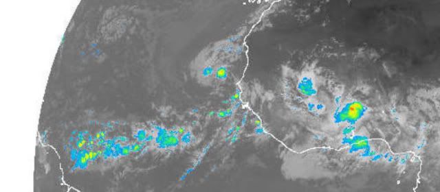
....Whereas let's see if the other area behind can sustain some persistent and concentrate convection :cheesy:
0 likes   

stevetampa33614

Re: Well Defined Wave off African Coast

#259 Postby stevetampa33614 » Tue Jul 22, 2008 6:43 am

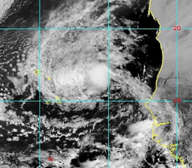
americanrebel wrote:I would have to say we have TD 5 there if not TS Eduardo at the 11 advisory.


While it may be, NHC isnt gonna say anything until Cristobal and Dolly are out of the picture. May be an Invest. Certainly not Eduaord by 11:00
0 likes   

User avatar
cycloneye
Admin
Admin
Posts: 145300
Age: 68
Joined: Thu Oct 10, 2002 10:54 am
Location: San Juan, Puerto Rico

Re: Well Defined Wave off African Coast

#260 Postby cycloneye » Tue Jul 22, 2008 7:06 am

ABNT20 KNHC 221205
TWOAT
TROPICAL WEATHER OUTLOOK
NWS TPC/NATIONAL HURRICANE CENTER MIAMI FL
800 AM EDT TUE JUL 22 2008

FOR THE NORTH ATLANTIC...CARIBBEAN SEA AND THE GULF OF MEXICO...

THE NATIONAL HURRICANE CENTER IS ISSUING ADVISORIES ON TROPICAL
STORM CRISTOBAL...CENTERED ABOUT 450 MILES SOUTH-SOUTHWEST OF
HALIFAX NOVA SCOTIA...AND ON TROPICAL STORM DOLLY...LOCATED ABOUT
265 MILES SOUTHEAST OF BROWNSVILLE TEXAS.

A LARGE AND WELL-DEFINED TROPICAL WAVE IS LOCATED OVER THE FAR
EASTERN ATLANTIC NEAR THE CAPE VERDE ISLANDS. ALTHOUGH THIS SYSTEM
WILL BE TRAVERSING RELATIVELY COOL WATERS...IT STILL HAS SOME
POTENTIAL FOR TROPICAL CYCLONE FORMATION AS IT MOVES GENERALLY
WESTWARD OVER THE NEXT COUPLE OF DAYS.

ELSEWHERE...TROPICAL CYCLONE FORMATION IS NOT EXPECTED DURING THE
NEXT 48 HOURS.

$$
FORECASTER AVILA/BLAKE
0 likes   


Return to “Talkin' Tropics”

Who is online

Users browsing this forum: No registered users and 35 guests