Large Tropical Wave in Central Atlantic

This is the general tropical discussion area. Anyone can take their shot at predicting a storms path.

Moderator: S2k Moderators

Forum rules

The posts in this forum are NOT official forecasts and should not be used as such. They are just the opinion of the poster and may or may not be backed by sound meteorological data. They are NOT endorsed by any professional institution or STORM2K. For official information, please refer to products from the National Hurricane Center and National Weather Service.

Help Support Storm2K
Message
Author
User avatar
HURAKAN
Professional-Met
Professional-Met
Posts: 46086
Age: 38
Joined: Thu May 20, 2004 4:34 pm
Location: Key West, FL
Contact:

#41 Postby HURAKAN » Wed Jul 23, 2008 11:00 pm

Image

Image

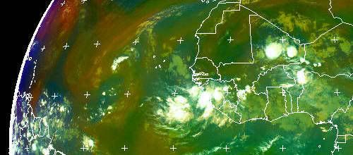
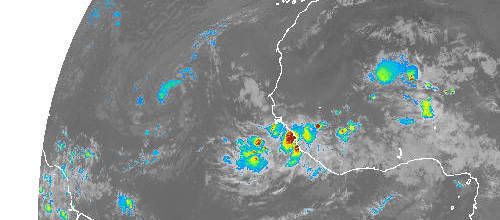
You may be watching future 98L.
0 likes   

Matt-hurricanewatcher

Re: Another Tropical Wave with Low in Africa

#42 Postby Matt-hurricanewatcher » Wed Jul 23, 2008 11:00 pm

I like what I see southeast of the Cape verdes, also it is "lower" over warmer waters. So it is worth watching.
0 likes   

User avatar
Vortex
S2K Supporter
S2K Supporter
Posts: 4644
Age: 53
Joined: Fri Aug 01, 2003 9:34 pm
Location: Hilton Head, SC

Re: Another Tropical Wave with Low in Africa

#43 Postby Vortex » Wed Jul 23, 2008 11:02 pm

cycloneye,

Thanks for posting that image. IMO, this will be the storm that needs to be watched very closely including those in the islands and points west to include mainland US
0 likes   

njweather
Tropical Storm
Tropical Storm
Posts: 169
Joined: Fri Aug 17, 2007 10:45 pm
Location: Washington, DC

Re: Another Tropical Wave with Low in Africa

#44 Postby njweather » Wed Jul 23, 2008 11:24 pm

Well, SAL isn't an issue:

Image
0 likes   

User avatar
cheezyWXguy
Category 5
Category 5
Posts: 6108
Joined: Mon Feb 13, 2006 12:29 am
Location: Dallas, TX

Re: Another Tropical Wave with Low in Africa

#45 Postby cheezyWXguy » Wed Jul 23, 2008 11:33 pm

I think both this and 97L need to be watched very carefully...97L looking a little better, but this looks great and conditions appear to support development. I saw cycloneye's image on page 2, and the first thing that came to mind was in 2004 when danielle, earl, and frances were seen all at the same time traversing the atlantic...my, what a sight that was.
0 likes   

RL3AO
Moderator-Pro Met
Moderator-Pro Met
Posts: 16308
Joined: Thu Jun 14, 2007 10:03 pm
Location: NC

#46 Postby RL3AO » Wed Jul 23, 2008 11:45 pm

These waves will have a negative MJO wave to deal with soon.

Image
0 likes   

User avatar
cheezyWXguy
Category 5
Category 5
Posts: 6108
Joined: Mon Feb 13, 2006 12:29 am
Location: Dallas, TX

Re:

#47 Postby cheezyWXguy » Wed Jul 23, 2008 11:52 pm

RL3AO wrote:These waves will have a negative MJO wave to deal with soon.

Image

It doesnt matter too much...not exactly the deciding factor between development or not and Im sure many storms have formed during a negative mjo. If Im correct, the epac has been out of a +mjo for at least a week or 2 and it continues to boom out new storms every few days, currently at #7...i dont see why we couldnt see a few in the atlantic as well.
0 likes   

Mecklenburg

Re: Another Tropical Wave with Low in Africa

#48 Postby Mecklenburg » Thu Jul 24, 2008 12:03 am

what's an mjo?
0 likes   

JonathanBelles
Professional-Met
Professional-Met
Posts: 11430
Age: 35
Joined: Sat Dec 24, 2005 9:00 pm
Location: School: Florida State University (Tallahassee, FL) Home: St. Petersburg, Florida
Contact:

Re:

#49 Postby JonathanBelles » Thu Jul 24, 2008 12:08 am

RL3AO wrote:These waves will have a negative MJO wave to deal with soon.

Image


I sort of expected MJO to be the reason of the latest peak in TC activity.
0 likes   

RL3AO
Moderator-Pro Met
Moderator-Pro Met
Posts: 16308
Joined: Thu Jun 14, 2007 10:03 pm
Location: NC

Re: Another Tropical Wave with Low in Africa

#50 Postby RL3AO » Thu Jul 24, 2008 12:27 am

Mecklenburg wrote:what's an mjo?


MJO = Madden-Julian oscillation

Basically its a global pattern of increased and decreased rainfall caused by higher and lower upper level divergence (Pro met confirmation?)

Image


Basically the brown lines mean decreased precipitation and the green lines mean increased precipitation. It also appears to be related to tropical cyclone formation. Over the past few weeks, the Atlantic and East Pacific was in a very favorable MJO wave and during that time Bertha formed with the East Pacific being busy as well. Now the Atlantic is entering a negative MJO phase. It doesn't mean tropical cyclones can't form (Dolly did), but it just makes the conditions not as favorable.
0 likes   

fasterdisaster
Category 5
Category 5
Posts: 1868
Joined: Mon Sep 19, 2005 4:41 pm
Location: Miami, Florida

#51 Postby fasterdisaster » Thu Jul 24, 2008 2:34 am

Is the center of circulation technically still on Africa or has it entered water?

If so when would it be 98L?
0 likes   

User avatar
N2FSU
S2K Supporter
S2K Supporter
Posts: 1062
Joined: Thu Sep 04, 2003 2:04 pm
Location: Tallahassee, FL

Re: Another Tropical Wave with Low in Africa

#52 Postby N2FSU » Thu Jul 24, 2008 4:24 am

Looks really good coming off of Africa:


Image
0 likes   

User avatar
KWT
Category 5
Category 5
Posts: 31415
Joined: Tue Aug 17, 2004 11:02 am
Location: UK!!!

#53 Postby KWT » Thu Jul 24, 2008 4:34 am

Well its got a large mass of convection though some of that may well be ITCZ stuff anyway its hard to say but still it does look det. 97L will probably get going first followed by this which IMO has a high chance of being 98L.
0 likes   

User avatar
cycloneye
Admin
Admin
Posts: 145295
Age: 68
Joined: Thu Oct 10, 2002 10:54 am
Location: San Juan, Puerto Rico

Re: Another Tropical Wave with Low emerges Africa

#54 Postby cycloneye » Thu Jul 24, 2008 5:44 am

Here,you can see ex 97L and the mass of clouds emerging Africa SE of that.

Image
0 likes   

User avatar
perk
Category 3
Category 3
Posts: 825
Joined: Mon Aug 09, 2004 9:35 am
Location: Richmond Texas

Re: Another Tropical Wave with Low emerges Africa

#55 Postby perk » Thu Jul 24, 2008 5:59 am

Well with only 7 days left in July i think we will squeeze at least one more TC in.
0 likes   

User avatar
gatorcane
S2K Supporter
S2K Supporter
Posts: 23691
Age: 47
Joined: Sun Mar 13, 2005 3:54 pm
Location: Boca Raton, FL

Re: Another Tropical Wave with Low emerges Africa

#56 Postby gatorcane » Thu Jul 24, 2008 7:18 am

SSTs are plenty warm enough and are in fact above normal this year in that area. I think there is a decent chance the convection could sustain over the next 24-48 hours (instead of going poof).
0 likes   

User avatar
Blown Away
S2K Supporter
S2K Supporter
Posts: 10145
Joined: Wed May 26, 2004 6:17 am

Re: Another Tropical Wave with Low emerges Africa

#57 Postby Blown Away » Thu Jul 24, 2008 7:27 am

Are the long range models still latching on to this wave and bringing it near the islands next week?
0 likes   

Frank2
Category 5
Category 5
Posts: 4061
Joined: Mon Jul 25, 2005 12:47 pm

#58 Postby Frank2 » Thu Jul 24, 2008 7:30 am

The GFS doesn't show anything in particular, other than the subtropical ridge migrating east and west during that period...
0 likes   

User avatar
Gustywind
Category 5
Category 5
Posts: 12334
Joined: Mon Sep 03, 2007 7:29 am
Location: Baie-Mahault, GUADELOUPE

#59 Postby Gustywind » Thu Jul 24, 2008 7:32 am

:uarrow:
Good question Blown_away :).... :roll: ??? What are the recents runs for this one??? Any models right now with this wave?
0 likes   

User avatar
Gustywind
Category 5
Category 5
Posts: 12334
Joined: Mon Sep 03, 2007 7:29 am
Location: Baie-Mahault, GUADELOUPE

#60 Postby Gustywind » Thu Jul 24, 2008 7:43 am

http://www.wunderground.com/blog/JeffMa ... amp=200807

Elsewhere in the tropics
The GFS model is predicting development of a new tropical wave, due to move off the coast of Africa 4-5 days from now.
I'll have an update Thursday.

Jeff Masters
0 likes   


Return to “Talkin' Tropics”

Who is online

Users browsing this forum: 7cardinal, Google Adsense [Bot], TomballEd and 37 guests