
So its picked up 0.2 degrees in latitude recently, not all that surprising given the heavier convection now in place compared to before. It seems like when it loses convection it track slightly south of west, when it gains convection it probably taps into a slightly higher steering current which takes it a little to the north of west.
Also now to the south of Bertha's track.
Ex Invest 99L in Western Atlantic
Moderator: S2k Moderators
-
Extremeweatherguy

- Category 5

- Posts: 11095
- Joined: Mon Oct 10, 2005 8:13 pm
- Location: Florida
Re: ATL: Invest 99L in Central Atlantic
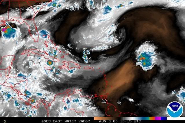
Latest steering currents for weak systems: http://cimss.ssec.wisc.edu/tropic/real- ... 8dlm1.html
0 likes
Re: ATL: Invest 99L in Central Atlantic
That's exactly the steering I figured from the WV loop. Recurve before US. There's a weak ULL to its NW right now in tandem west.
Has that sleeper Andrew look but too early with no US steering pattern.
Other African wave to SE dissipated.
Has that sleeper Andrew look but too early with no US steering pattern.
Other African wave to SE dissipated.
0 likes
-
Blown Away

- S2K Supporter

- Posts: 10253
- Joined: Wed May 26, 2004 6:17 am
Re: ATL: Invest 99L in Central Atlantic
If I'm reading the TAFB correctly, it shows 99L's low near the NE Caribbean in 24 hours, not consistent w/ the models.
http://www.nhc.noaa.gov/tafb_latest/atl ... BW_sm3.gif
Then into PR as a wave in 48 hours.
http://www.nhc.noaa.gov/tafb_latest/atl ... BW_sm3.gif
Then S of Cuba in 72 hours.
http://www.nhc.noaa.gov/tafb_latest/atl ... BW_sm3.gif
http://www.nhc.noaa.gov/tafb_latest/atl ... BW_sm3.gif
Then into PR as a wave in 48 hours.
http://www.nhc.noaa.gov/tafb_latest/atl ... BW_sm3.gif
Then S of Cuba in 72 hours.
http://www.nhc.noaa.gov/tafb_latest/atl ... BW_sm3.gif
0 likes
-
Blown Away
- S2K Supporter
- Posts: 10253
- Joined: Wed May 26, 2004 6:17 am
-
Emmett_Brown

- Category 5
- Posts: 1433
- Joined: Wed Aug 24, 2005 9:10 pm
- Location: Sarasota FL
Re: ATL: Invest 99L in Central Atlantic
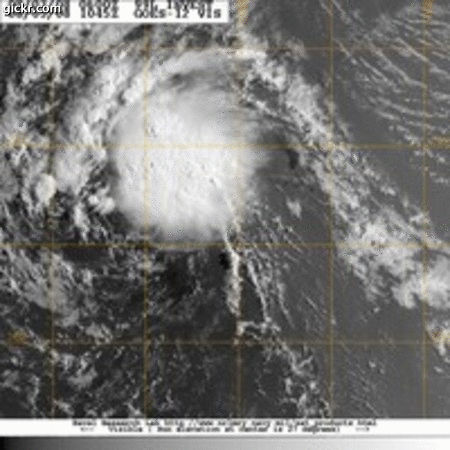
Blown_away wrote:Doesn't seem to be much of an LLC left.
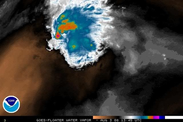
http://www.ssd.noaa.gov/goes/flt/t1/loop-vis.html
In those last couple of frames you can see the burst of convection weakening. You are right, the LLC is hard to find. Perhaps it was pulled under the convection to the north. Still doesnt appear to be able to sustain convection. The bursts are keeping the wave going, but equally seem to be disrupting any LLC whenever they fire up.
0 likes
-
Gustywind

- Category 5
- Posts: 12334
- Joined: Mon Sep 03, 2007 7:29 am
- Location: Baie-Mahault, GUADELOUPE
000
FZNT23 KNHC 030912
OFFNT3
OFFSHORE WATERS FORECAST FOR THE SOUTHWEST AND TROPICAL NORTH
ATLANTIC AND CARIBBEAN SEA
NWS TPC/NATIONAL HURRICANE CENTER MIAMI FL
530 AM EDT SUN AUG 03 2008
AMZ089-031530-
SYNOPSIS FOR CARIBBEAN SEA AND TROPICAL N ATLC FROM 07N TO 22N
BETWEEN 55W AND 65W
530 AM EDT SUN AUG 03 2008
ANOTHER TROPICAL WAVE E OF AREA WILL APPROACH 55W NIGHT AND
TRACK THROUGH THE EASTERN AND CENTRAL CARIBBEAN MON THROUGH TUE
AND INTO THE WESTERN CARIBBEAN WED AND THU. LOW PRES ALONG THE
TROPICAL WAVE MAY POSSIBLY BECOME A TROPICAL CYCLONE.
0 likes
-
storms in NC

- S2K Supporter
- Posts: 2338
- Joined: Thu Jul 28, 2005 2:58 pm
- Location: Wallace,NC 40 miles NE of Wilm
- Contact:
Re: ATL: Invest 99L in Central Atlantic
Emmett_Brown wrote:Blown_away wrote:Doesn't seem to be much of an LLC left.
http://www.ssd.noaa.gov/goes/flt/t1/loop-vis.html
In those last couple of frames you can see the burst of convection weakening. You are right, the LLC is hard to find. Perhaps it was pulled under the convection to the north. Still doesnt appear to be able to sustain convection. The bursts are keeping the wave going, but equally seem to be disrupting any LLC whenever they fire up.
True but we have seen storms do this and just refire back up to get stronger. but if it stays weak it will be only a matter of time to be a open wave again. But if it can keep burst of convection going it should do okay. Only time will till if it will build up or go in to a open wave.
0 likes
-
Blown Away
- S2K Supporter
- Posts: 10253
- Joined: Wed May 26, 2004 6:17 am
Re: ATL: Invest 99L in Central Atlantic
Gustywind, That's consistent w/ the TAFB but not consistent w/ the models.
0 likes


-
storms in NC
- S2K Supporter
- Posts: 2338
- Joined: Thu Jul 28, 2005 2:58 pm
- Location: Wallace,NC 40 miles NE of Wilm
- Contact:
Re:
KWT wrote:What I've noticed with these systems is that the LLC tends to weaken a lot when convection blows up, we've seen it several times before but we shall see.
Doesn't look bad right now even if the convection is waning but that should help to keep the system on the westerly track.
But do we really want it to get a westerly track? Wouldn't a out to sea be nice?
0 likes
-
storms in NC
- S2K Supporter
- Posts: 2338
- Joined: Thu Jul 28, 2005 2:58 pm
- Location: Wallace,NC 40 miles NE of Wilm
- Contact:
Re:
KWT wrote:Not really no as it rasies the threat of a landfall somewhere and even a close shave can obviously raise the worry factor.
Looks like there is shear to the west of this system which could be a problem for this system and keep it weak.
I am sorry I was picking. But I understand what you are saying
0 likes
-
Blown Away
- S2K Supporter
- Posts: 10253
- Joined: Wed May 26, 2004 6:17 am
Re: ATL: Invest 99L in Central Atlantic
What is the latest LLC position, got to think it's over 19N by now.
0 likes
-
Blown Away
- S2K Supporter
- Posts: 10253
- Joined: Wed May 26, 2004 6:17 am
Re: ATL: Invest 99L in Central Atlantic
IMO, I don't see 99L developing, if it ever does, before it reaches at least 65W. 99L should remain shallow and continue moving just N of due W and be near 21N/65W in 48 hours.
0 likes
Who is online
Users browsing this forum: No registered users and 9 guests