ATL: Tropical Depression Edouard

Moderator: S2k Moderators

Message
Author
jhamps10

#1341 Postby jhamps10 » Mon Aug 04, 2008 4:41 am

recon found center at 28N,90.07W
pressure 1002
max FL winds of 47 kts in the NE quad of storm.
0 likes   

User avatar
KWT
Category 5
Category 5
Posts: 31415
Joined: Tue Aug 17, 2004 11:02 am
Location: UK!!!

#1342 Postby KWT » Mon Aug 04, 2008 4:47 am

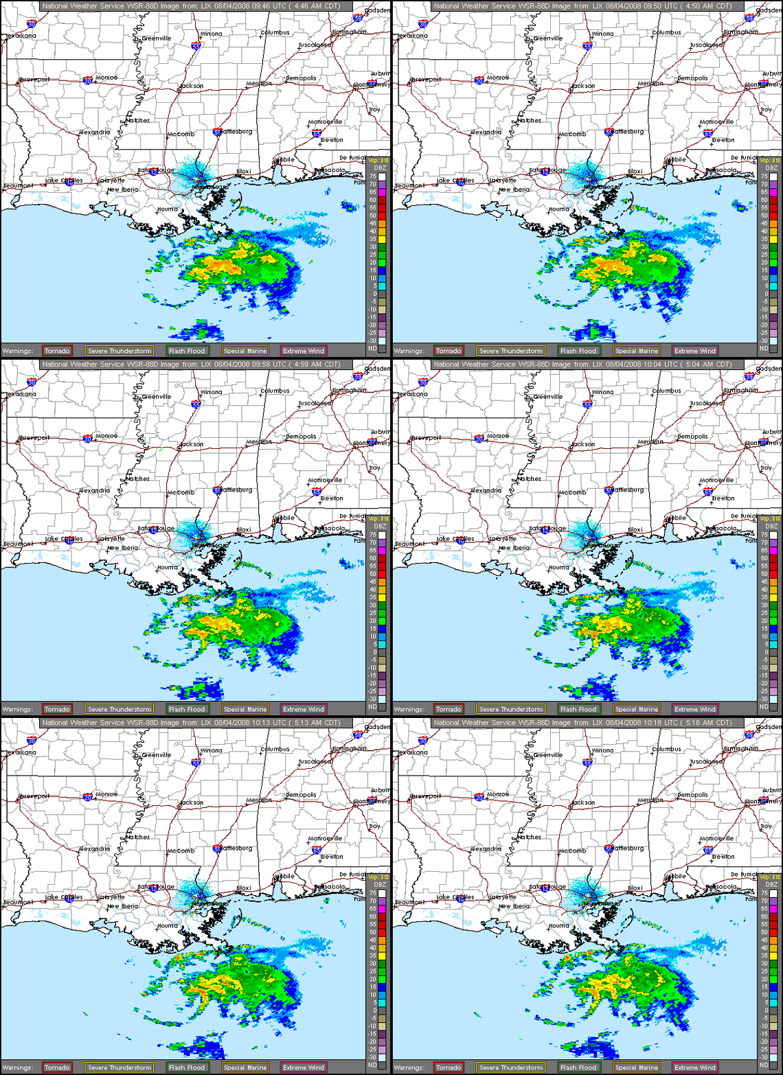
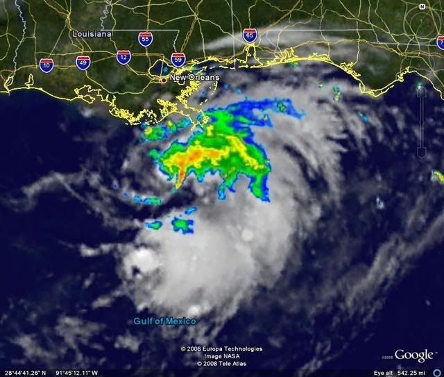
Does look like convection has increased on the northern side which is very interesting to observe because it hints that the system is starting to wrap around and lose that shear presentation.

Also the radar does look interesitng, convection finally is trying to wrap around the northern side.
0 likes   

User avatar
HURAKAN
Professional-Met
Professional-Met
Posts: 46086
Age: 38
Joined: Thu May 20, 2004 4:34 pm
Location: Key West, FL
Contact:

#1343 Postby HURAKAN » Mon Aug 04, 2008 5:10 am

Image
0 likes   

User avatar
Normandy
Category 5
Category 5
Posts: 2293
Joined: Sun Oct 10, 2004 12:31 am
Location: Houston, TX

Re: ATL: Tropical Storm Edouard - Gulf of Mexico

#1344 Postby Normandy » Mon Aug 04, 2008 5:12 am

Edouard is starting to look pretty good on radar, very nice curved band is around the COC now and a primitive eyewall is starting to organize it seems. Looks like the start of a core.
0 likes   

User avatar
KatDaddy
Category 5
Category 5
Posts: 2815
Joined: Mon Oct 21, 2002 6:23 pm
Location: League City, Texas

#1345 Postby KatDaddy » Mon Aug 04, 2008 5:13 am

Banding becoming visible on Lake Charles long range radar.

http://radar.weather.gov/radar.php?rid= ... 11&loop=no
Last edited by KatDaddy on Mon Aug 04, 2008 5:17 am, edited 1 time in total.
0 likes   

User avatar
KWT
Category 5
Category 5
Posts: 31415
Joined: Tue Aug 17, 2004 11:02 am
Location: UK!!!

#1346 Postby KWT » Mon Aug 04, 2008 5:15 am

I also am starting to think its trying to develop an inner core, still needs better convective coverage but its on its way now and the shear earlier may end up helping the system fan out?
0 likes   

xironman
S2K Supporter
S2K Supporter
Posts: 2522
Joined: Sun Jun 10, 2007 4:53 pm
Location: NoVA

Re: ATL: Tropical Storm Edouard - Gulf of Mexico

#1347 Postby xironman » Mon Aug 04, 2008 5:20 am

0 likes   

User avatar
Normandy
Category 5
Category 5
Posts: 2293
Joined: Sun Oct 10, 2004 12:31 am
Location: Houston, TX

Re:

#1348 Postby Normandy » Mon Aug 04, 2008 5:21 am

KWT wrote:I also am starting to think its trying to develop an inner core, still needs better convective coverage but its on its way now and the shear earlier may end up helping the system fan out?


Once shear drops Ed has a VERY good outflow channel to its south in that ULL near the Yucatan. Once it gets a core it could get very strong....maybe scary depending on how fast the core develops. Remember that Ed is not some sprawled out cyclone, it is very compact and such small cyclones are prone to SEVERE changes in intensity (both up and down)....Humberto, Charley, Lorenzo, etc. 36 more hours is plenty....had Humberto had 10 more hours it would have been borderline 3/4 in my opinion. Not saying THAT will happen, just saying keep alert.
0 likes   

User avatar
KWT
Category 5
Category 5
Posts: 31415
Joined: Tue Aug 17, 2004 11:02 am
Location: UK!!!

#1349 Postby KWT » Mon Aug 04, 2008 5:23 am

Well this one does have more time then Humberto, esp if it can stay south of the guidence like the last recon fixes suggested was the case. As you say Normandy compact systems do have a habit of strengthening pretty rapidly in good conditions.
0 likes   

User avatar
HURAKAN
Professional-Met
Professional-Met
Posts: 46086
Age: 38
Joined: Thu May 20, 2004 4:34 pm
Location: Key West, FL
Contact:

#1350 Postby HURAKAN » Mon Aug 04, 2008 5:23 am

Image

Image

Image
0 likes   

User avatar
KWT
Category 5
Category 5
Posts: 31415
Joined: Tue Aug 17, 2004 11:02 am
Location: UK!!!

#1351 Postby KWT » Mon Aug 04, 2008 5:28 am

Looks like the convection is mainly firing on the eastern side now, need to see more on the western side before we get overly excited.
0 likes   

User avatar
HURAKAN
Professional-Met
Professional-Met
Posts: 46086
Age: 38
Joined: Thu May 20, 2004 4:34 pm
Location: Key West, FL
Contact:

#1352 Postby HURAKAN » Mon Aug 04, 2008 5:33 am

AL, 05, 2008080406, , BEST, 0, 281N, 896W, 45, 1005, TS
0 likes   

User avatar
KWT
Category 5
Category 5
Posts: 31415
Joined: Tue Aug 17, 2004 11:02 am
Location: UK!!!

#1353 Postby KWT » Mon Aug 04, 2008 5:36 am

Yep still at 45kts back then even when it didn't look great, at least now t does once again look around 45kts though looks can fool!
0 likes   

xironman
S2K Supporter
S2K Supporter
Posts: 2522
Joined: Sun Jun 10, 2007 4:53 pm
Location: NoVA

#1354 Postby xironman » Mon Aug 04, 2008 5:40 am

If you zoom in on the shortwave http://www.ssd.noaa.gov/goes/east/se/loop-ir2.html, you can see the convection blow back over the llc.
0 likes   

User avatar
HURAKAN
Professional-Met
Professional-Met
Posts: 46086
Age: 38
Joined: Thu May 20, 2004 4:34 pm
Location: Key West, FL
Contact:

#1355 Postby HURAKAN » Mon Aug 04, 2008 5:42 am

Image
0 likes   

Matt-hurricanewatcher

Re: ATL: Tropical Storm Edouard - Gulf of Mexico

#1356 Postby Matt-hurricanewatcher » Mon Aug 04, 2008 6:01 am

04/0545 UTC 28.2N 89.7W T2.0/2.0 EDOUARD -- Atlantic Ocean


Now pro's don't get mad because of what I'm going to say.

But this goe's to show that systems with less then 2.5t can be tropical storms, in even fairly strong ones at that. So it goes to show you that nothing works on a linear line with tropical cyclones. I also seen this with Arlene, Alberto, Alison; in a few others.
0 likes   

User avatar
KWT
Category 5
Category 5
Posts: 31415
Joined: Tue Aug 17, 2004 11:02 am
Location: UK!!!

#1357 Postby KWT » Mon Aug 04, 2008 6:07 am

Yep Matt in this case we have data from recon that obviously over rides those estimates.

Convection still strongly firing on the easternside as well
0 likes   

User avatar
Thunder44
Category 5
Category 5
Posts: 5922
Age: 44
Joined: Mon Jun 09, 2003 7:53 pm
Location: New York City

Re: ATL: Tropical Storm Edouard - Gulf of Mexico

#1358 Postby Thunder44 » Mon Aug 04, 2008 6:09 am

Matt-hurricanewatcher wrote:04/0545 UTC 28.2N 89.7W T2.0/2.0 EDOUARD -- Atlantic Ocean


Now pro's don't get mad because of what I'm going to say.

But this goe's to show that systems with less then 2.5t can be tropical storms, in even fairly strong ones at that. So it goes to show you that nothing works on a linear line with tropical cyclones. I also seen this with Arlene, Alberto, Alison; in a few others.


There's nothing wrong with what you are saying. It just shows how unreliable the Dvorak estimates for any system may be. Having recon is always better.
0 likes   

User avatar
Lowpressure
S2K Supporter
S2K Supporter
Posts: 2032
Age: 58
Joined: Sun Sep 14, 2003 9:17 am
Location: Charlotte, North Carolina

Re: ATL: Tropical Storm Edouard - Gulf of Mexico

#1359 Postby Lowpressure » Mon Aug 04, 2008 6:11 am

Convection starting to wrap around LLC as a few have eluded to. Today could prove quite interesting for some. Good thing is recon only has to look out the kitchen window- Kessler AFB is about a 5 iron shot away. Should relay a ton of info back, especially if this pans out as another intensifying storm on landfall approach to Texas.
0 likes   

User avatar
KWT
Category 5
Category 5
Posts: 31415
Joined: Tue Aug 17, 2004 11:02 am
Location: UK!!!

#1360 Postby KWT » Mon Aug 04, 2008 6:19 am

Also worth noting that some deeper convection now becoming evident in that eastern mass as we hit the dmax.

Edouard slowly looking more healthy again after taking a bad turn last night.
0 likes   


Return to “2008”

Who is online

Users browsing this forum: No registered users and 3 guests