recon found center at 28N,90.07W
pressure 1002
max FL winds of 47 kts in the NE quad of storm.
ATL: Tropical Depression Edouard
Moderator: S2k Moderators


Re: ATL: Tropical Storm Edouard - Gulf of Mexico
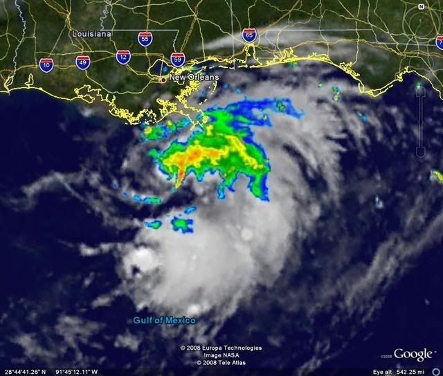
Edouard is starting to look pretty good on radar, very nice curved band is around the COC now and a primitive eyewall is starting to organize it seems. Looks like the start of a core.
0 likes

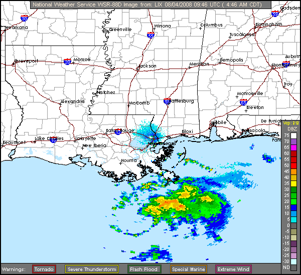
Banding becoming visible on Lake Charles long range radar.
http://radar.weather.gov/radar.php?rid= ... 11&loop=no
http://radar.weather.gov/radar.php?rid= ... 11&loop=no
Last edited by KatDaddy on Mon Aug 04, 2008 5:17 am, edited 1 time in total.
0 likes
Re: ATL: Tropical Storm Edouard - Gulf of Mexico
Starting to get some of those pretty reds near the center http://wwwghcc.msfc.nasa.gov/cgi-bin/get-goes?satellite=GOES-E%20CONUS&lat=28&lon=-90&zoom=1&palette=spect.pal&type=Animation&numframes=6&quality=90
0 likes
Re:
KWT wrote:I also am starting to think its trying to develop an inner core, still needs better convective coverage but its on its way now and the shear earlier may end up helping the system fan out?
Once shear drops Ed has a VERY good outflow channel to its south in that ULL near the Yucatan. Once it gets a core it could get very strong....maybe scary depending on how fast the core develops. Remember that Ed is not some sprawled out cyclone, it is very compact and such small cyclones are prone to SEVERE changes in intensity (both up and down)....Humberto, Charley, Lorenzo, etc. 36 more hours is plenty....had Humberto had 10 more hours it would have been borderline 3/4 in my opinion. Not saying THAT will happen, just saying keep alert.
0 likes


If you zoom in on the shortwave http://www.ssd.noaa.gov/goes/east/se/loop-ir2.html, you can see the convection blow back over the llc.
0 likes
-
Matt-hurricanewatcher
Re: ATL: Tropical Storm Edouard - Gulf of Mexico
04/0545 UTC 28.2N 89.7W T2.0/2.0 EDOUARD -- Atlantic Ocean
Now pro's don't get mad because of what I'm going to say.
But this goe's to show that systems with less then 2.5t can be tropical storms, in even fairly strong ones at that. So it goes to show you that nothing works on a linear line with tropical cyclones. I also seen this with Arlene, Alberto, Alison; in a few others.
0 likes

Re: ATL: Tropical Storm Edouard - Gulf of Mexico
Matt-hurricanewatcher wrote:04/0545 UTC 28.2N 89.7W T2.0/2.0 EDOUARD -- Atlantic Ocean
Now pro's don't get mad because of what I'm going to say.
But this goe's to show that systems with less then 2.5t can be tropical storms, in even fairly strong ones at that. So it goes to show you that nothing works on a linear line with tropical cyclones. I also seen this with Arlene, Alberto, Alison; in a few others.
There's nothing wrong with what you are saying. It just shows how unreliable the Dvorak estimates for any system may be. Having recon is always better.
0 likes
-
Lowpressure

- S2K Supporter

- Posts: 2032
- Age: 59
- Joined: Sun Sep 14, 2003 9:17 am
- Location: Charlotte, North Carolina
Re: ATL: Tropical Storm Edouard - Gulf of Mexico
Convection starting to wrap around LLC as a few have eluded to. Today could prove quite interesting for some. Good thing is recon only has to look out the kitchen window- Kessler AFB is about a 5 iron shot away. Should relay a ton of info back, especially if this pans out as another intensifying storm on landfall approach to Texas.
0 likes
Who is online
Users browsing this forum: No registered users and 8 guests