
Will be very interesting to watch txwatcher91.
Does anyone think with the upper trough still nearby this could get some Baroclinc aid when its over Florida as it gets further north?
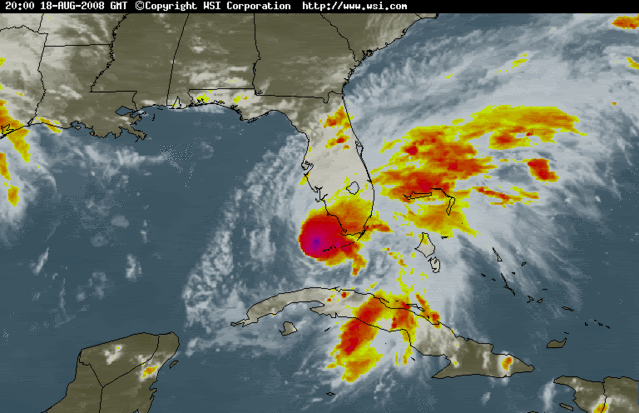
ATL: Tropical Depression Fay
Moderator: S2k Moderators


URNT12 KNHC 190008
VORTEX DATA MESSAGE AL062008
A. 18/23:36:00Z
B. 24 deg 57 min N
081 deg 51 min W
C. 850 mb 1405 m
D. NA kt
E. 312 deg 31 nm
F. 052 deg 037 kt
G. 312 deg 031 nm
H. EXTRAP 998 mb
I. 17 C/ 1524 m
J. 19 C/ 1525 m
K. 14 C/ NA
L. NA
M. NA
N. 134/8
O. 0.02 / 2 nm
P. AF309 2006A FAY OB 04
MAX FL WIND 37 KT NW QUAD 23:26:30 Z
MAX OUTBOUND FL WIND 53 KT SE QUAD 2353Z
SLP EXTRAP FROM 850 MB
0 likes
-
tolakram
- Admin

- Posts: 20183
- Age: 62
- Joined: Sun Aug 27, 2006 8:23 pm
- Location: Florence, KY (name is Mark)
Re: ATL: Tropical Storm Fay South of Naples
AT 800 PM EDT...0000Z...THE CENTER OF TROPICAL STORM FAY WAS LOCATED
NEAR LATITUDE 25.0 NORTH...LONGITUDE 81.9 WEST OR ABOUT 105
MILES...170 KM...SOUTH OF NAPLES FLORIDA.
FAY IS MOVING TOWARD THE NORTH NEAR 9 MPH...15 KM/HR. THIS GENERAL
MOTION IS EXPECTED TO CONTINUE TONIGHT AND TUESDAY. ON THE
FORECAST TRACK...THE CENTER OF FAY WILL CROSS THE SOUTHWESTERN
COAST OF FLORIDA ON TUESDAY.
This is NOT a forecast and this plot may not be accurate.
Last edited by tolakram on Mon Aug 18, 2008 7:24 pm, edited 1 time in total.
0 likes
-
DESTRUCTION5

- Category 5

- Posts: 4430
- Age: 44
- Joined: Wed Sep 03, 2003 11:25 am
- Location: Stuart, FL
Re:
KWT wrote:If you were to extrap a northerly motion out of that then we are looking at it heading just west of Naples, of course i;m very aware that there could be an easterly jog as it gets close to making landfall, we've seen it so many times now...
Everglades City looks probable to me...
http://radar.weather.gov/radar.php?prod ... x&loop=yes
0 likes
Re: Re:
DESTRUCTION5 wrote:KWT wrote:If you were to extrap a northerly motion out of that then we are looking at it heading just west of Naples, of course i;m very aware that there could be an easterly jog as it gets close to making landfall, we've seen it so many times now...
Everglades City looks probable to me...
http://radar.weather.gov/radar.php?prod ... x&loop=yes
yes indeed that main meso cyclone is doing it's WSW heading now and will complete a small loop in the next hour or so, as the mass goes IMO N about 5 degees, this puts landfall just west of everglades city in my best guess
but really as derek showed earlier the highest winds are displaced to the NE
i mean they were laughing on TWC when they went to jim cantore in Naples and the storms winds haven't even reached him yet, in fact it seemed CALM, while the storm remained less than a hundred miles away.
0 likes
-
93superstorm
- Tropical Depression

- Posts: 79
- Joined: Mon Jul 07, 2008 11:41 am
for now this look like its heading pretty close to the Naples region. As expected the track has been pretty erratic at times with regards to the center location.
Last edited by KWT on Mon Aug 18, 2008 7:29 pm, edited 1 time in total.
0 likes

Re: ATL: Tropical Storm Fay South of Naples
tolakram wrote:Winds on the increase in Key West
to quote Austin Powers
"Whoop-dee-doo, what does it all mean, Basil?"
0 likes
-
Extremeweatherguy

- Category 5
- Posts: 11095
- Joined: Mon Oct 10, 2005 8:13 pm
- Location: Florida
Re: ATL: Tropical Storm Fay South of Naples
tolakram wrote:Winds on the increase in Key West
watch the winds increase and the pressure go down a bit one last time as the meso cyclone sweeps down and then east just to the north of key west in the next 90 minutes IMO
0 likes
-
storms in NC

- S2K Supporter

- Posts: 2338
- Joined: Thu Jul 28, 2005 2:58 pm
- Location: Wallace,NC 40 miles NE of Wilm
- Contact:
I called my daughter in Ft Myers and she said the people are nuts. She said work closed so they could go home and get done what they needed to do. My daughter was asked if she was scared? She told them no she was from NC she been though quite a few. Even told them about Flood and the lost of our home.
I taught My kids good. They know how to enjoy the storm but also know what to do and not to do. My kids like going out in the wind. or they would sit on the porch and count how many trees they hear going down. Wood behind the house.
She said she couldn't get over how people act around there when a Hurricane comes. My daughter has her own home since she was 19. So she know about fixing the home too. The last one Wilma bent her metal door. and had to replace the carpet. Little things. One thing she really got mad was the Ins people went sky high. She told them where to go and got new.
I know she will be safe. I hope others will the safe.But I am a Mother I will worry.
0 likes
Re: Re:
DESTRUCTION5 wrote:KWT wrote:If you were to extrap a northerly motion out of that then we are looking at it heading just west of Naples, of course i;m very aware that there could be an easterly jog as it gets close to making landfall, we've seen it so many times now...
Everglades City looks probable to me...
http://radar.weather.gov/radar.php?prod ... x&loop=yes
If it decides to track a little more to the NNE/NE then it may end up close but right now given the motion being northerly I think Naples looks best.
0 likes
-
caneman
Re: ATL: Tropical Storm Fay South of Naples
I think it is going to stair step its way right up to Ft. Myers. it's been doing it all along why should it stop now. The trend is your friend.
0 likes
-
Evil Jeremy

- S2K Supporter
- Posts: 5463
- Age: 32
- Joined: Mon Apr 10, 2006 2:10 pm
- Location: Los Angeles, CA
Who is online
Users browsing this forum: No registered users and 21 guests