
Based on ground obs.
Moderator: S2k Moderators


HURAKAN wrote:
Based on ground obs.
Frank P wrote:HURAKAN wrote:
Based on ground obs.
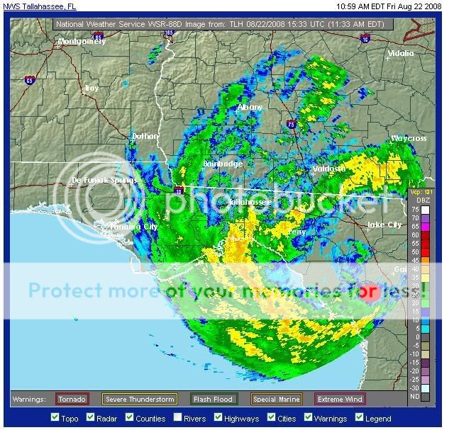
From what I can tell looking at multiple radars that's pretty close in my opinion.. might be a tad more to the west but still hard to imagine how this COC won't get a least a little taste of the GOM... setting up to be a really crappy weekend along the NGOM
Steve wrote:>>setting up to be a really crappy weekend along the NGOM
I suggested to Ivanhater last night that he ice up the brews. In your case, I'm going to have to go ahead and recommend you check the whiskey supply for mint julips at the Pell house.
Gonna hit the store tonight just in case I'll be consuming a few cold ones on Sunday for any outlying feeder bands we might see down in Lafourche.
Steve
Javlin wrote:Steve wrote:>>setting up to be a really crappy weekend along the NGOM
I suggested to Ivanhater last night that he ice up the brews. In your case, I'm going to have to go ahead and recommend you check the whiskey supply for mint julips at the Pell house.
Gonna hit the store tonight just in case I'll be consuming a few cold ones on Sunday for any outlying feeder bands we might see down in Lafourche.
Steve
Didn't you get the invite Steve?shinding at Frank's place Sunday you're invitedKevin

Steve wrote:>>setting up to be a really crappy weekend along the NGOM
I suggested to Ivanhater last night that he ice up the brews. In your case, I'm going to have to go ahead and recommend you check the whiskey supply for mint julips at the Pell house.
Gonna hit the store tonight just in case I'll be consuming a few cold ones on Sunday for any outlying feeder bands we might see down in Lafourche.
Steve
1130 AM EDT FRI AUG 22 2008
THE NATIONAL WEATHER SERVICE IN CHARLESTON HAS ISSUED A
* TORNADO WARNING FOR...
NORTHWESTERN BULLOCH COUNTY IN SOUTHEAST GEORGIA...
NORTH CENTRAL CANDLER COUNTY IN SOUTHEAST GEORGIA...
JENKINS COUNTY IN SOUTHEAST GEORGIA...
SCREVEN COUNTY IN SOUTHEAST GEORGIA...
* UNTIL 1230 PM EDT
* AT 1128 AM EDT...NATIONAL WEATHER SERVICE DOPPLER RADAR INDICATED A
LINE OF SEVERE THUNDERSTORMS CAPABLE OF PRODUCING A TORNADO ALONG A
LINE EXTENDING FROM 7 MILES EAST OF HUNTERS TO 7 MILES WEST OF
PORTAL...OR ALONG A LINE EXTENDING FROM 13 MILES EAST OF SYLVANIA
TO 9 MILES NORTH OF METTER...MOVING NORTHWEST AT 32 MPH.
* SOME LOCATIONS IN OR NEAR THE PATH OF THE STORM INCLUDE...
HUNTERS...PORTAL...
ROCKY FORD...ALTMAN...
SYLVANIA...
WOODCLIFF...SCARBORO...
HILLTONIA...
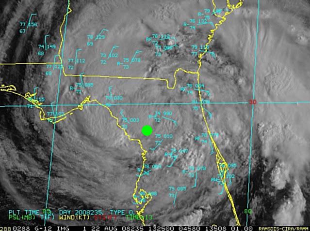
HURAKAN wrote:Gainesville is reporting winds from the SE, which means that the center is to its SW. If the center was to the west of Gainesville, you would expect wind to be blowing from the south.
Users browsing this forum: No registered users and 17 guests


