ATL: Tropical Depression Fay

Moderator: S2k Moderators

Message
Author
User avatar
HURAKAN
Professional-Met
Professional-Met
Posts: 46086
Age: 38
Joined: Thu May 20, 2004 4:34 pm
Location: Key West, FL
Contact:

#12661 Postby HURAKAN » Fri Aug 22, 2008 10:20 am

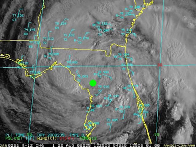
Image

Based on ground obs.
0 likes   

tolakram
Admin
Admin
Posts: 20009
Age: 62
Joined: Sun Aug 27, 2006 8:23 pm
Location: Florence, KY (name is Mark)

Re: ATL: Tropical Storm Fay over northern Florida Penninsula

#12662 Postby tolakram » Fri Aug 22, 2008 10:23 am

AT 1100 AM EDT...1500Z...THE CENTER OF TROPICAL STORM FAY WAS
LOCATED NEAR LATITUDE 29.6 NORTH...LONGITUDE 82.7 WEST OR ABOUT 40
MILES... 70 KM...NORTHEAST OF CEDAR KEY FLORIDA.

Image
0 likes   

User avatar
Steve
S2K Supporter
S2K Supporter
Posts: 9621
Joined: Sat Apr 05, 2003 11:41 pm
Location: Not a state-caster

#12663 Postby Steve » Fri Aug 22, 2008 10:24 am

>>Could Fay be trying to form a new center closer to the gulf? Or is that big band of convection out in the gulf pulling it? Looking at radar.

Hard to say. Was just looking at the visible floater loop and wondering whether it was heading WNW or if this was a possiblity. The only thing I can get is by zooming in the 1 hour total and figuring at least some of the center is E and SE of Perry. FWIW, nasty feeder band running along the coast right now from Daytona up through southern Duval County. Nasty stuff there. Outer fringes brought numerous tornado warnings to coastal South Carolina last night, so those are nothing to play with.

http://radar.weather.gov/radar.php?rid= ... 1&loop=yes
0 likes   

Jason_B

Re: ATL: Tropical Storm Fay over northern Florida Penninsula

#12664 Postby Jason_B » Fri Aug 22, 2008 10:24 am

Weird, center doesn't look that far south on radar. Then again probably shouldn't be using radar to determine where the center is.
0 likes   

User avatar
Enzo Aquarius
Tropical Storm
Tropical Storm
Posts: 160
Joined: Wed Jul 23, 2008 12:53 pm
Location: Canada

Re: ATL: Tropical Storm Fay over northern Florida Penninsula

#12665 Postby Enzo Aquarius » Fri Aug 22, 2008 10:25 am

Fay just doesn't want to quit, and she still looks amazing after all this time, even with being a land-lover. :eek:
0 likes   

Frank P
S2K Supporter
S2K Supporter
Posts: 2776
Joined: Fri Aug 29, 2003 10:52 am
Location: Biloxi Beach, Ms
Contact:

Re:

#12666 Postby Frank P » Fri Aug 22, 2008 10:26 am

HURAKAN wrote:Image

Based on ground obs.


From what I can tell looking at multiple radars that's pretty close in my opinion.. might be a tad more to the west but still hard to imagine how this COC won't get a least a little taste of the GOM... setting up to be a really crappy weekend along the NGOM
0 likes   

User avatar
mutley
S2K Supporter
S2K Supporter
Posts: 311
Joined: Wed Aug 15, 2007 7:18 am
Location: Gainesville, FL

Re:

#12667 Postby mutley » Fri Aug 22, 2008 10:27 am

HURAKAN wrote:Based on ground obs.


I guess ground obs don't lie, but radar can.
0 likes   

User avatar
mutley
S2K Supporter
S2K Supporter
Posts: 311
Joined: Wed Aug 15, 2007 7:18 am
Location: Gainesville, FL

Re: Re:

#12668 Postby mutley » Fri Aug 22, 2008 10:31 am

Frank P wrote:
HURAKAN wrote:Image

Based on ground obs.


From what I can tell looking at multiple radars that's pretty close in my opinion.. might be a tad more to the west but still hard to imagine how this COC won't get a least a little taste of the GOM... setting up to be a really crappy weekend along the NGOM


I think your right. Should very interesting to watch the evolution, if any, when she gets over water. Actually, Fay has been an interesting storm all along.
0 likes   

User avatar
Steve
S2K Supporter
S2K Supporter
Posts: 9621
Joined: Sat Apr 05, 2003 11:41 pm
Location: Not a state-caster

#12669 Postby Steve » Fri Aug 22, 2008 10:32 am

>>setting up to be a really crappy weekend along the NGOM

I suggested to Ivanhater last night that he ice up the brews. In your case, I'm going to have to go ahead and recommend you check the whiskey supply for mint julips at the Pell house. :)

Gonna hit the store tonight just in case I'll be consuming a few cold ones on Sunday for any outlying feeder bands we might see down in Lafourche.

Steve
0 likes   

xironman
S2K Supporter
S2K Supporter
Posts: 2522
Joined: Sun Jun 10, 2007 4:53 pm
Location: NoVA

Re: ATL: Tropical Storm Fay over northern Florida Penninsula

#12670 Postby xironman » Fri Aug 22, 2008 10:37 am

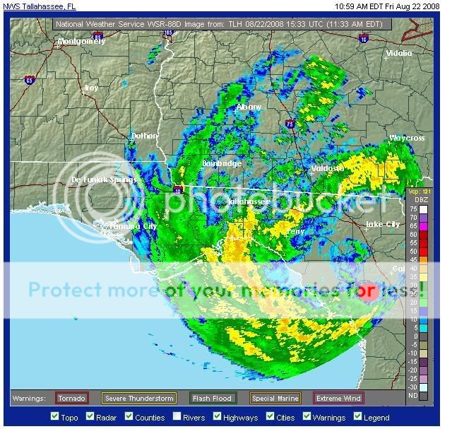
Tallahassee radar shows the spin pretty close to the NHC position west of Gainesville http://radar.weather.gov/radar.php?product=N0R&rid=tlh&loop=yes. It is actually close to some convection.
0 likes   

Javlin
Category 5
Category 5
Posts: 1620
Age: 64
Joined: Fri Jul 09, 2004 7:58 pm
Location: ms gulf coast

Re:

#12671 Postby Javlin » Fri Aug 22, 2008 10:37 am

Steve wrote:>>setting up to be a really crappy weekend along the NGOM

I suggested to Ivanhater last night that he ice up the brews. In your case, I'm going to have to go ahead and recommend you check the whiskey supply for mint julips at the Pell house. :)

Gonna hit the store tonight just in case I'll be consuming a few cold ones on Sunday for any outlying feeder bands we might see down in Lafourche.

Steve

Didn't you get the invite Steve?shinding at Frank's place Sunday you're invited :D Kevin
0 likes   

User avatar
HURAKAN
Professional-Met
Professional-Met
Posts: 46086
Age: 38
Joined: Thu May 20, 2004 4:34 pm
Location: Key West, FL
Contact:

#12672 Postby HURAKAN » Fri Aug 22, 2008 10:40 am

Gainesville is reporting winds from the SE, which means that the center is to its SW. If the center was to the west of Gainesville, you would expect wind to be blowing from the south.
0 likes   

User avatar
gboudx
S2K Supporter
S2K Supporter
Posts: 4080
Joined: Thu Sep 04, 2003 1:39 pm
Location: Rockwall, Tx but from Harvey, La

Re: Re:

#12673 Postby gboudx » Fri Aug 22, 2008 10:40 am

Javlin wrote:
Steve wrote:>>setting up to be a really crappy weekend along the NGOM

I suggested to Ivanhater last night that he ice up the brews. In your case, I'm going to have to go ahead and recommend you check the whiskey supply for mint julips at the Pell house. :)

Gonna hit the store tonight just in case I'll be consuming a few cold ones on Sunday for any outlying feeder bands we might see down in Lafourche.

Steve

Didn't you get the invite Steve?shinding at Frank's place Sunday you're invited :D Kevin


Steve rolls hard. You may not know what you're in for. ;)
0 likes   

JonathanBelles
Professional-Met
Professional-Met
Posts: 11430
Age: 35
Joined: Sat Dec 24, 2005 9:00 pm
Location: School: Florida State University (Tallahassee, FL) Home: St. Petersburg, Florida
Contact:

#12674 Postby JonathanBelles » Fri Aug 22, 2008 10:43 am

The Visible looks like somebody put shaving cream all over Florida and Georgia.
0 likes   

User avatar
Enzo Aquarius
Tropical Storm
Tropical Storm
Posts: 160
Joined: Wed Jul 23, 2008 12:53 pm
Location: Canada

Re: ATL: Tropical Storm Fay over northern Florida Penninsula

#12675 Postby Enzo Aquarius » Fri Aug 22, 2008 10:44 am

Water levels:

Dunnellon north of Tampa is near Flood Stage, Deland to the east of Dunnellon is in Action Stage.

There are no other flooding reports in northern Florida based on meter readings, although water levels are steadily rising on many as Fay moves on through. The Suwannee river is rapidly rising however.

For anybody checking the water meter page on NOAA, a meter in Louisiana is reporting moderate flooding, but this is due to an error. So no, Fay has not sent a huge amount of rain all the way to Louisiana yet. :P

EDIT: Missed out on Macclenny at northeast Florida. It's at flood stage now, and expected to enter Moderate Stage.
0 likes   

Frank P
S2K Supporter
S2K Supporter
Posts: 2776
Joined: Fri Aug 29, 2003 10:52 am
Location: Biloxi Beach, Ms
Contact:

Re:

#12676 Postby Frank P » Fri Aug 22, 2008 10:46 am

Steve wrote:>>setting up to be a really crappy weekend along the NGOM

I suggested to Ivanhater last night that he ice up the brews. In your case, I'm going to have to go ahead and recommend you check the whiskey supply for mint julips at the Pell house. :)

Gonna hit the store tonight just in case I'll be consuming a few cold ones on Sunday for any outlying feeder bands we might see down in Lafourche.

Steve


Steve/Jav, old pals.. you two always have an open invite to the Pell beach house .. got a real good stock of Crown which I'll toast to a feedband or two on the front porch if we happen to get any pass through the area this weekend.....

I actually cancelled a trip this weekend to TN because of Fay.. ya never know, besides I didn't want to drive in torrential rain coming home on Sun or Mon...
0 likes   

User avatar
Enzo Aquarius
Tropical Storm
Tropical Storm
Posts: 160
Joined: Wed Jul 23, 2008 12:53 pm
Location: Canada

Re: ATL: Tropical Storm Fay over northern Florida Penninsula

#12677 Postby Enzo Aquarius » Fri Aug 22, 2008 10:48 am

1130 AM EDT FRI AUG 22 2008

THE NATIONAL WEATHER SERVICE IN CHARLESTON HAS ISSUED A

* TORNADO WARNING FOR...
NORTHWESTERN BULLOCH COUNTY IN SOUTHEAST GEORGIA...
NORTH CENTRAL CANDLER COUNTY IN SOUTHEAST GEORGIA...
JENKINS COUNTY IN SOUTHEAST GEORGIA...
SCREVEN COUNTY IN SOUTHEAST GEORGIA...

* UNTIL 1230 PM EDT

* AT 1128 AM EDT...NATIONAL WEATHER SERVICE DOPPLER RADAR INDICATED A
LINE OF SEVERE THUNDERSTORMS CAPABLE OF PRODUCING A TORNADO ALONG A
LINE EXTENDING FROM 7 MILES EAST OF HUNTERS TO 7 MILES WEST OF
PORTAL...OR ALONG A LINE EXTENDING FROM 13 MILES EAST OF SYLVANIA
TO 9 MILES NORTH OF METTER...MOVING NORTHWEST AT 32 MPH.

* SOME LOCATIONS IN OR NEAR THE PATH OF THE STORM INCLUDE...
HUNTERS...PORTAL...
ROCKY FORD...ALTMAN...
SYLVANIA...
WOODCLIFF...SCARBORO...
HILLTONIA...
0 likes   

Sanibel
Category 5
Category 5
Posts: 10375
Joined: Mon Aug 30, 2004 11:06 pm
Location: Offshore SW Florida

Re: ATL: Tropical Storm Fay over northern Florida Penninsula

#12678 Postby Sanibel » Fri Aug 22, 2008 10:49 am

5 minute downpour and thunder from Fay over us.

Crumbling center headed WNW on NHC track.
0 likes   

xironman
S2K Supporter
S2K Supporter
Posts: 2522
Joined: Sun Jun 10, 2007 4:53 pm
Location: NoVA

Re:

#12679 Postby xironman » Fri Aug 22, 2008 10:50 am

HURAKAN wrote:Gainesville is reporting winds from the SE, which means that the center is to its SW. If the center was to the west of Gainesville, you would expect wind to be blowing from the south.

You are correct my west was an approximation. Here is where I was talking about, red dot, a bit SW.

Image
0 likes   

User avatar
ronjon
Category 5
Category 5
Posts: 4822
Joined: Fri Aug 19, 2005 5:17 pm
Location: Hernando Beach, FL

Re: ATL: Tropical Storm Fay over northern Florida Penninsula

#12680 Postby ronjon » Fri Aug 22, 2008 10:51 am

Looks like the center is moving slowly west in northern Levy County - about 20-30 miles north of Cedar Key. Nice convective burst over the west side of the center in the NE GOM - she's getting close now - maybe 20 or 30 miles from water. Overall oblong shape (W-E) of circulation seems to showing how hard high pressure is pushing down on Fay from the north.

http://radar.weather.gov/ridge/Conus/southeast_loop.php
0 likes   


Return to “2008”

Who is online

Users browsing this forum: No registered users and 7 guests