ATL: IKE Discussion

Moderator: S2k Moderators

Message
Author
User avatar
haml8
Tropical Storm
Tropical Storm
Posts: 188
Age: 49
Joined: Sun Aug 19, 2007 10:03 pm
Location: Katy, Texas
Contact:

Re: ATL IKE: Category 2 - Discussion

#5441 Postby haml8 » Mon Sep 08, 2008 11:56 am

Ed Mahmoud wrote:No major hurricane has hit HOU area since Dr. Frank arrived, and although retired, KHOU-TV11 calls him back into the studio for tropical events, like Hurricane Dolly and T.S. Edouard, so his force field still protects us.

Image


Long Live the The Houston Hurricane Shield!! Hip Hip Hooray, Hip Hip Hooray. Hopefully I will see him on the 6:00 News tonight
0 likes   

User avatar
HouTXmetro
Category 5
Category 5
Posts: 3949
Joined: Sun Jun 13, 2004 6:00 pm
Location: District of Columbia, USA

#5442 Postby HouTXmetro » Mon Sep 08, 2008 11:56 am

I'm seeinf WNW in the last frames.... could be a wobble but it should have been WNW last night.
0 likes   

User avatar
dixiebreeze
S2K Supporter
S2K Supporter
Posts: 5140
Joined: Wed Sep 03, 2003 5:07 pm
Location: crystal river, fla.

Re: ATL IKE: Category 2 - Discussion

#5443 Postby dixiebreeze » Mon Sep 08, 2008 11:58 am

I'm going for a really BIG GUESS and say Mobile or Pensacola.
0 likes   

pablolopez26
Tropical Storm
Tropical Storm
Posts: 137
Joined: Wed Aug 27, 2008 5:10 pm

Re: ATL IKE: Category 2 - Discussion

#5444 Postby pablolopez26 » Mon Sep 08, 2008 11:59 am

haml8 wrote:No major hurricane has hit HOU area since Dr. Frank arrived, and although retired, KHOU-TV11 calls him back into the studio for tropical events, like Hurricane Dolly and T.S. Edouard, so his force field still protects us.

Image


Dr. Neil Frank is my hero.
0 likes   

User avatar
KWT
Category 5
Category 5
Posts: 31415
Joined: Tue Aug 17, 2004 11:02 am
Location: UK!!!

#5445 Postby KWT » Mon Sep 08, 2008 11:59 am

I'm still seeing around 275, I think the reason it looks like its wobbling to the WNW is the northern quadrant is wrapping round the center again, if you focus on the eye feature here you can see still near west:

http://hadar.cira.colostate.edu/ramsdis ... ive_0.html

Give it time to load up everything though!
0 likes   

User avatar
HURAKAN
Professional-Met
Professional-Met
Posts: 46086
Age: 38
Joined: Thu May 20, 2004 4:34 pm
Location: Key West, FL
Contact:

#5446 Postby HURAKAN » Mon Sep 08, 2008 12:00 pm

Image
0 likes   

mattpetre
Category 2
Category 2
Posts: 510
Age: 53
Joined: Mon Sep 19, 2005 3:20 pm
Location: Missouri City,TX & Galleria
Contact:

Re: ATL IKE: Category 2 - Discussion

#5447 Postby mattpetre » Mon Sep 08, 2008 12:01 pm

Not sure if it's been mentioned here yet or not but TX is currently in their H-120 mode for emergency response.

ftp://ftp.txdps.state.tx.us/dem/sitrep/ ... 708%20(GOV).pdf

Nice to see that even the emergency response coordinators have a sense of humor (that's what gets us through the tough times...) Notice all the mentions of StrIKE in the document :)
0 likes   

jlauderdal
S2K Supporter
S2K Supporter
Posts: 7183
Joined: Wed May 19, 2004 5:46 am
Location: NE Fort Lauderdale
Contact:

Re: ATL IKE: Category 2 - Discussion

#5448 Postby jlauderdal » Mon Sep 08, 2008 12:01 pm

pablolopez26 wrote:
haml8 wrote:No major hurricane has hit HOU area since Dr. Frank arrived, and although retired, KHOU-TV11 calls him back into the studio for tropical events, like Hurricane Dolly and T.S. Edouard, so his force field still protects us.

Image


Dr. Neil Frank is my hero.


he might be a hero but that haircut is on track with a mullet
0 likes   

User avatar
VeniceInlet
Tropical Depression
Tropical Depression
Posts: 92
Joined: Sun Jun 11, 2006 10:12 pm
Location: Nokomis, FL

Re: ATL IKE: Category 2 - Discussion

#5449 Postby VeniceInlet » Mon Sep 08, 2008 12:02 pm

haml8 wrote:
Ed Mahmoud wrote:No major hurricane has hit HOU area since Dr. Frank arrived, and although retired, KHOU-TV11 calls him back into the studio for tropical events, like Hurricane Dolly and T.S. Edouard, so his force field still protects us.

Image


Long Live the The Houston Hurricane Shield!! Hip Hip Hooray, Hip Hip Hooray. Hopefully I will see him on the 6:00 News tonight


I remember him, he was great.

Do y'all still have that nutbag Marvin Zindler? :lol:
0 likes   

User avatar
funster
Category 3
Category 3
Posts: 816
Joined: Sat Dec 29, 2007 4:27 pm
Location: North Dallas

Re:

#5450 Postby funster » Mon Sep 08, 2008 12:03 pm

HURAKAN wrote:Image


Impressive looking. Someone please shove Ike back on land before he cranks up to a Cat 4 again.
0 likes   

User avatar
KWT
Category 5
Category 5
Posts: 31415
Joined: Tue Aug 17, 2004 11:02 am
Location: UK!!!

Re: ATL IKE: Category 2 - Discussion

#5451 Postby KWT » Mon Sep 08, 2008 12:03 pm

funster wrote:
Ed Mahmoud wrote:No major hurricane has hit HOU area since Dr. Frank arrived, and although retired, KHOU-TV11 calls him back into the studio for tropical events, like Hurricane Dolly and T.S. Edouard, so his force field still protects us.

Image


His aerodynamic haircut must have something to do with it 8-)


:lol:

I dare say he may be popping back for hurricane Ike given the current model agreement on either a close shave or hit on Texas.
0 likes   

User avatar
haml8
Tropical Storm
Tropical Storm
Posts: 188
Age: 49
Joined: Sun Aug 19, 2007 10:03 pm
Location: Katy, Texas
Contact:

Re: ATL IKE: Category 2 - Discussion

#5452 Postby haml8 » Mon Sep 08, 2008 12:05 pm

VeniceInlet wrote:
haml8 wrote:
Ed Mahmoud wrote:No major hurricane has hit HOU area since Dr. Frank arrived, and although retired, KHOU-TV11 calls him back into the studio for tropical events, like Hurricane Dolly and T.S. Edouard, so his force field still protects us.

Image


Long Live the The Houston Hurricane Shield!! Hip Hip Hooray, Hip Hip Hooray. Hopefully I will see him on the 6:00 News tonight


I remember him, he was great.

Do y'all still have that nutbag Marvin Zindler? :lol:


No.. http://en.wikipedia.org/wiki/Marvin_Zindler
0 likes   

tolakram
Admin
Admin
Posts: 20009
Age: 62
Joined: Sun Aug 27, 2006 8:23 pm
Location: Florence, KY (name is Mark)

Re: ATL IKE: Category 2 - Discussion

#5453 Postby tolakram » Mon Sep 08, 2008 12:06 pm

Can we stop the non Ike chatter please. :)
0 likes   

N2Storms
Category 1
Category 1
Posts: 324
Joined: Thu Sep 04, 2003 1:37 pm
Location: Panama City, Florida

Re: ATL IKE: Category 2 - Discussion

#5454 Postby N2Storms » Mon Sep 08, 2008 12:06 pm

[quote="Sabanic"][quote="inda_iwall"]I think the further south, the longer it takes until landfall which will only make it landfall further east, and the short time over cuba makes it stronger and heads more poleward, I believe landfall in SE LA, and into MS, AL is no longer out of possibility, especially if it slows more and spends more time down south and allows the high to weaken and/or move off. What so people tink of this possibility. This is just my own non-met thought process. [b]Although from the stale hot air we have in place here in NGC, that high does not seem to be weakening.[/b][/quote]

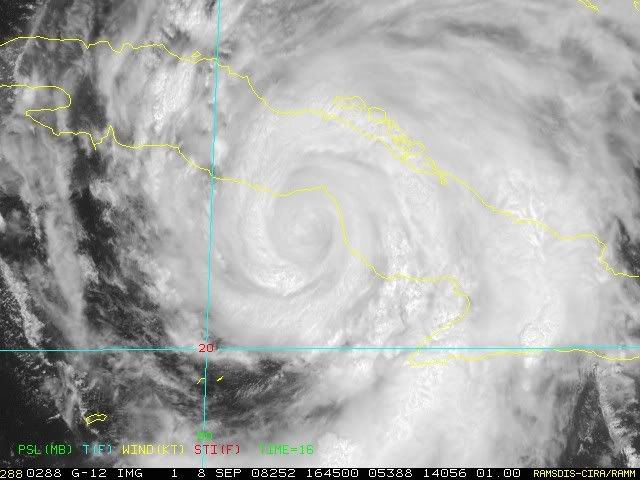
It is not weakening, and is not forecast to begin weakening until Wednesday. That's when we are supposed to get the return of Showers & Thunderstorms. All the things you mention though do make sense. My point is that if you look at the NHC's forecast track 24 hours ago, Ike is not following it. That's 24 hours. What a difference 96 - 144 could make.[/quote]


Our local Met here in PC mentioned last night that it was not out of the realm of possibility that Ike would go a bit farther south and west than forecasted by the NHC...by mid week the High is supposed to become suppressed and it may cause Ike to slow down considerably in the Gulf...if he is still in the Gulf on Friday or Saturday then the next trough sweeping down from the NW would be strong enough to shunt Ike NEwd towards Miss ro Alabama this weekend...

I'm not in any way stating that this is what I think will happen...merely throwing out what one of our local mets offered up last night as a possible scenario...
0 likes   

User avatar
cycloneye
Admin
Admin
Posts: 145350
Age: 68
Joined: Thu Oct 10, 2002 10:54 am
Location: San Juan, Puerto Rico

Re: ATL IKE: Category 2 - Discussion

#5455 Postby cycloneye » Mon Sep 08, 2008 12:06 pm

12:55 PM EDT:

Image
0 likes   

pablolopez26
Tropical Storm
Tropical Storm
Posts: 137
Joined: Wed Aug 27, 2008 5:10 pm

Re: ATL IKE: Category 2 - Discussion

#5456 Postby pablolopez26 » Mon Sep 08, 2008 12:07 pm

mattpetre wrote:Not sure if it's been mentioned here yet or not but TX is currently in their H-120 mode for emergency response.

ftp://ftp.txdps.state.tx.us/dem/sitrep/ ... 708%20(GOV).pdf

Nice to see that even the emergency response coordinators have a sense of humor (that's what gets us through the tough times...) Notice all the mentions of StrIKE in the document :)


I cant read your link. I figured we were in H-120 mode, all the of the freeway signs say keep your gas tanks full and stuff.
0 likes   

User avatar
AJC3
Admin
Admin
Posts: 3999
Age: 61
Joined: Tue Aug 31, 2004 7:04 pm
Location: Ballston Spa, New York
Contact:

Re: ATL IKE: Category 2 - Discussion

#5457 Postby AJC3 » Mon Sep 08, 2008 12:08 pm

jlauderdal wrote: Image

he might be a hero but that haircut is on track with a mullet


Image

Ok, I think I went too far...LOL.
0 likes   

amanda
Tropical Low
Tropical Low
Posts: 26
Joined: Tue Aug 19, 2008 12:52 pm
Location: lakeland, fl

Re: ATL IKE: Category 2 - Discussion

#5458 Postby amanda » Mon Sep 08, 2008 12:09 pm

jlauderdal wrote:
pablolopez26 wrote:
haml8 wrote:No major hurricane has hit HOU area since Dr. Frank arrived, and although retired, KHOU-TV11 calls him back into the studio for tropical events, like Hurricane Dolly and T.S. Edouard, so his force field still protects us.

Image


Dr. Neil Frank is my hero.


he might be a hero but that haircut is on track with a mullet


now THAT we can say with 100% accuracy! no disclaimer here.
0 likes   

User avatar
KWT
Category 5
Category 5
Posts: 31415
Joined: Tue Aug 17, 2004 11:02 am
Location: UK!!!

#5459 Postby KWT » Mon Sep 08, 2008 12:10 pm

I think we do have something of a battle on right now between the inner core and the outer eyewall, butr the outer eyewall can't complete it seems because there is land which allowing the inner eyewall to hold.

Still holding due west! :eek:
0 likes   

mattpetre
Category 2
Category 2
Posts: 510
Age: 53
Joined: Mon Sep 19, 2005 3:20 pm
Location: Missouri City,TX & Galleria
Contact:

Re: ATL IKE: Category 2 - Discussion

#5460 Postby mattpetre » Mon Sep 08, 2008 12:11 pm

pablolopez26 wrote:
mattpetre wrote:Not sure if it's been mentioned here yet or not but TX is currently in their H-120 mode for emergency response.

ftp://ftp.txdps.state.tx.us/dem/sitrep/ ... 708%20(GOV).pdf

Nice to see that even the emergency response coordinators have a sense of humor (that's what gets us through the tough times...) Notice all the mentions of StrIKE in the document :)


I cant read your link. I figured we were in H-120 mode, all the of the freeway signs say keep your gas tanks full and stuff.


Try this...
ftp://ftp.txdps.state.tx.us/dem/sitrep/Hurricane%20Ike%20SITREP%201%20090708%20(GOV).pdf
0 likes   


Return to “2008”

Who is online

Users browsing this forum: No registered users and 6 guests