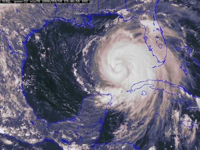
ATL: IKE Discussion

Moderator: S2k Moderators

Message
Author
User avatar
Sabanic
Category 2
Category 2
Posts: 683
Age: 65
Joined: Wed Aug 01, 2007 7:01 am
Location: Mobile, AL
Contact:

Re: Re:

#7761 Postby Sabanic » Wed Sep 10, 2008 3:11 pm

Senobia wrote:
Sabanic wrote:
dwg71 wrote:Movement about 10 miles an hour, WNW to W turn should commence soon. Just at the top end of WNW now, or bottom end of NW.


Better . . . ( Sry guys )


Better for whom and how so?

Thank you kindly for your clarification.


Would prefer a SW dive but that is not going to happen. Bad choice of words, so no need to get upset
0 likes   

User avatar
SMNederlandTX
Tropical Depression
Tropical Depression
Posts: 57
Age: 50
Joined: Fri Aug 17, 2007 7:02 pm
Location: Nederland, TX

Re: ATL IKE: Category 2 - Discussion

#7762 Postby SMNederlandTX » Wed Sep 10, 2008 3:12 pm

What does that mean for the path? Same? Or further south, north? Sorry, I don't know anything about this stuff.

TampaFl wrote:Looks like the high over the Texas coast has gotten stronger. Ike is still stuck in the weakness between the Texas high & the one over the Atlantic. Thoughts & comments welcomed.


Image
0 likes   

mattpetre
Category 2
Category 2
Posts: 510
Age: 53
Joined: Mon Sep 19, 2005 3:20 pm
Location: Missouri City,TX & Galleria
Contact:

Re: ATL IKE: Category 2 - Discussion

#7763 Postby mattpetre » Wed Sep 10, 2008 3:12 pm

Panic mode is beginning to ensue to some extent. People are at work wondering why they are here rather than home making all the last preparations. We all (everyone on storm2k at least) knew that Ike was going to strengthen to at the very least a high end Cat 2, but the general public only starts to react once that actually comes to fruition. I agree with the mods and long-time posters... let's keep the chatter down! People need to know what the storm is doing in this discussion thread. I'll go to the preps thread for further comments about preps...

Meanwhile... Ike is really getting his act together. Looks like all talk of shear is gone and dry air following close behind.
0 likes   

User avatar
ConvergenceZone
Category 5
Category 5
Posts: 5194
Joined: Fri Jul 29, 2005 1:40 am
Location: Northern California

Re: ATL IKE: Category 2 - Discussion

#7764 Postby ConvergenceZone » Wed Sep 10, 2008 3:13 pm

I should have mentioned in my previous post that Ike will generate 10x the amount of headliness AFTER it hits, the Gustav did....Gustav was horrible, but from what mets and people like Jeff Masters are saying about Ike being potentially the worst storm texas has seen in 40 years, it's a bit scary to say the least. I just hope people are preparing. Don't panic, just be prepared.
Last edited by ConvergenceZone on Wed Sep 10, 2008 3:14 pm, edited 1 time in total.
0 likes   

dwg71
Category 5
Category 5
Posts: 2349
Joined: Wed Jun 08, 2005 4:34 pm

#7765 Postby dwg71 » Wed Sep 10, 2008 3:13 pm

as high gets stronger and continues to move east Ike will move more and more towards a more westerly course.
0 likes   

User avatar
TampaFl
S2K Supporter
S2K Supporter
Posts: 1904
Age: 67
Joined: Thu Sep 04, 2003 11:23 am
Location: Tampa, FL

Re: ATL IKE: Category 2 - Discussion

#7766 Postby TampaFl » Wed Sep 10, 2008 3:15 pm

SMNederlandTX wrote:What does that mean for the path? Same? Or further south, north? Sorry, I don't know anything about this stuff.

TampaFl wrote:Looks like the high over the Texas coast has gotten stronger. Ike is still stuck in the weakness between the Texas high & the one over the Atlantic. Thoughts & comments welcomed.


Image


It could move to the southwest again if the ridge is strong over Texas or it could continue to drift to the nw as currently forecast. Just MHO.
0 likes   

User avatar
deltadog03
Professional-Met
Professional-Met
Posts: 3580
Joined: Tue Jul 05, 2005 6:16 pm
Location: Macon, GA

#7767 Postby deltadog03 » Wed Sep 10, 2008 3:16 pm

That ridge over TX is fairly stationary.
0 likes   

User avatar
HURAKAN
Professional-Met
Professional-Met
Posts: 46086
Age: 38
Joined: Thu May 20, 2004 4:34 pm
Location: Key West, FL
Contact:

#7768 Postby HURAKAN » Wed Sep 10, 2008 3:16 pm

Image

So far Ike likes the gulf.
0 likes   

User avatar
Sabanic
Category 2
Category 2
Posts: 683
Age: 65
Joined: Wed Aug 01, 2007 7:01 am
Location: Mobile, AL
Contact:

Re:

#7769 Postby Sabanic » Wed Sep 10, 2008 3:19 pm

dwg71 wrote:as high gets stronger and continues to move east Ike will move more and more towards a more westerly course.


Depends. Could actually move him more westerly, or possibly WSW, or he could continue to move more northerly (NW)
0 likes   

Derek Ortt

#7770 Postby Derek Ortt » Wed Sep 10, 2008 3:19 pm

Ike should also continue to grow in size during the coming days.

Therefore, DO NOT FOCUS ON THE FORECAST TRACK. A large part of Texas and Louisiana are going to receive severe impacts from this one
0 likes   

Matt-hurricanewatcher

Re:

#7771 Postby Matt-hurricanewatcher » Wed Sep 10, 2008 3:21 pm

Derek Ortt wrote:Ike should also continue to grow in size during the coming days.

Therefore, DO NOT FOCUS ON THE FORECAST TRACK. A large part of Texas and Louisiana are going to receive severe impacts from this one


How big do you think it will get?
0 likes   

User avatar
SMNederlandTX
Tropical Depression
Tropical Depression
Posts: 57
Age: 50
Joined: Fri Aug 17, 2007 7:02 pm
Location: Nederland, TX

Re: ATL IKE: Category 2 - Discussion

#7772 Postby SMNederlandTX » Wed Sep 10, 2008 3:22 pm

I don't know if this can be forecasted or not....but does anyone know if there will be a lot of tornadoes with this and if so, how far from the center do you think they will occur? Probably a stupid question...but kinda curious.... :oops:
0 likes   

User avatar
terrapintransit
Category 1
Category 1
Posts: 275
Age: 50
Joined: Tue Sep 04, 2007 8:08 pm
Location: Williamsport, Pa

Re: ATL IKE: Category 2 - Discussion

#7773 Postby terrapintransit » Wed Sep 10, 2008 3:22 pm

The more strength Ike attains the more northerly he will go.... :eek:
0 likes   

Stormcenter
S2K Supporter
S2K Supporter
Posts: 6684
Joined: Wed Sep 03, 2003 11:27 am
Location: Houston, TX

Re: ATL IKE: Category 2 - Discussion

#7774 Postby Stormcenter » Wed Sep 10, 2008 3:23 pm

terrapintransit wrote:The more strength Ike attains the more northerly he will go.... :eek:


Huh?
0 likes   

User avatar
Lowpressure
S2K Supporter
S2K Supporter
Posts: 2032
Age: 58
Joined: Sun Sep 14, 2003 9:17 am
Location: Charlotte, North Carolina

Re: ATL IKE: Category 2 - Discussion

#7775 Postby Lowpressure » Wed Sep 10, 2008 3:24 pm

SMNederlandTX wrote:I don't know if this can be forecasted or not....but does anyone know if there will be a lot of tornadoes with this and if so, how far from the center do you think they will occur? Probably a stupid question...but kinda curious.... :oops:

Depends on several factors. Usually right front quad is more prone to be tornadic, but as we all saw with Gustav, it really depends on the air pattern that he bumps into over land.
0 likes   

User avatar
terrapintransit
Category 1
Category 1
Posts: 275
Age: 50
Joined: Tue Sep 04, 2007 8:08 pm
Location: Williamsport, Pa

Re: ATL IKE: Category 2 - Discussion

#7776 Postby terrapintransit » Wed Sep 10, 2008 3:25 pm

Stormcenter wrote:
terrapintransit wrote:The more strength Ike attains the more northerly he will go.... :eek:


Huh?


I believe I heard Steve Lyons talking about this at one time...
0 likes   

User avatar
jasons2k
Storm2k Executive
Storm2k Executive
Posts: 8245
Age: 51
Joined: Wed Jul 06, 2005 12:32 pm
Location: The Woodlands, TX

#7777 Postby jasons2k » Wed Sep 10, 2008 3:25 pm

People, goodness, please stop with the proclamations of Ike will do ____ unless you either really know what you're talking about or you have the data/model to back it up. WAY too many posts, that again, make no sense.
0 likes   

attallaman

Re: ATL IKE: Category 2 - Discussion

#7778 Postby attallaman » Wed Sep 10, 2008 3:25 pm

All this talk about the ridges, there's no chance of something developing in the upper atmosphere that would cause Ike to make a turn and come towards the C/GOM is there?
0 likes   

N2Storms
Category 1
Category 1
Posts: 324
Joined: Thu Sep 04, 2003 1:37 pm
Location: Panama City, Florida

Re: ATL IKE: Category 2 - Discussion

#7779 Postby N2Storms » Wed Sep 10, 2008 3:26 pm

[quote="Lowpressure"][quote="SMNederlandTX"]I don't know if this can be forecasted or not....but does anyone know if there will be a lot of tornadoes with this and if so, how far from the center do you think they will occur? Probably a stupid question...but kinda curious.... :oops:[/quote]
Depends on several factors. Usually right front quad is more prone to be tornadic, but as we all saw with Gustav, it really depends on the air pattern that he bumps into over land.[/quote]


quite frequently, if the storm is ingesting a lot of dry air it will tend to produce more tornadoes
0 likes   

User avatar
Lowpressure
S2K Supporter
S2K Supporter
Posts: 2032
Age: 58
Joined: Sun Sep 14, 2003 9:17 am
Location: Charlotte, North Carolina

Re: ATL IKE: Category 2 - Discussion

#7780 Postby Lowpressure » Wed Sep 10, 2008 3:28 pm

terrapintransit wrote:
Stormcenter wrote:
terrapintransit wrote:The more strength Ike attains the more northerly he will go.... :eek:


Huh?


I believe I heard Steve Lyons talking about this at one time...


That was a broad description that usually bigger (stronger) storms get pulled poleward over time as long as there are no other factors, ie ridge. Has little to do with Ike.
0 likes   


Return to “2008”

Who is online

Users browsing this forum: No registered users and 2 guests