ATL: IKE Discussion

Moderator: S2k Moderators

Message
Author
User avatar
Hurricanewatcher2007
Category 2
Category 2
Posts: 578
Joined: Sat Jul 05, 2008 8:10 pm

Re: ATL IKE: Category 2 - Discussion

#8581 Postby Hurricanewatcher2007 » Thu Sep 11, 2008 1:09 am

Melly wrote:
artinla1 wrote:That was 946 millibars in the northwest quad. The 940 earlier was not from the same quadrant.


So, erm what does that mean? Again I'm a Noob at all this...


It doesn't mean anything. Like I said above your post they get the pressure reading from the center of the system. In a organized system there should be only one center. In a disorganized tropical storm or depression you could have multiple centers rotating around a larger center but not in Hurricanes.
0 likes   

Matt-hurricanewatcher

Re: ATL IKE: Category 2 - Discussion

#8582 Postby Matt-hurricanewatcher » Thu Sep 11, 2008 1:10 am

Melly wrote:
artinla1 wrote:That was 946 millibars in the northwest quad. The 940 earlier was not from the same quadrant.


So, erm what does that mean? Again I'm a Noob at all this...


It means that there is one center and the pressure they found is higher then the last plane report of the pressure. Meaning the inner eye is weaking now...Looking at 85h shows a very very messy outter eyewall, so I would not expect any strengthing, I would not be suprized as the inner eye wall weakens, that this system weakens to around 75-80 knots. We will have to see how the outter eye wall forms over the next 12-18 hours....

Once it forms and contracts then expect strengthing then.
0 likes   

bob rulz
Category 5
Category 5
Posts: 1704
Age: 35
Joined: Sat Jan 28, 2006 7:30 pm
Location: Salt Lake City, Utah

Re: ATL IKE: Category 2 - Discussion

#8583 Postby bob rulz » Thu Sep 11, 2008 1:11 am

Melly wrote:
artinla1 wrote:That was 946 millibars in the northwest quad. The 940 earlier was not from the same quadrant.


So, erm what does that mean? Again I'm a Noob at all this...


Not sure what you're confused about but the 946 millibar pressure was reported in the northwestern quadrant, but an earlier recon pass found a lower pressure in a different quadrant of the hurricane so it may not have sampled the lowest pressure yet.

EDIT: Of course, the lowest pressure is supposed to be in the CENTER, not one of the quadrants. Which is why his post confused me too?
Last edited by bob rulz on Thu Sep 11, 2008 1:12 am, edited 1 time in total.
0 likes   

I-wall
Tropical Storm
Tropical Storm
Posts: 210
Joined: Wed Sep 10, 2008 5:24 pm

Re: ATL IKE: Category 2 - Discussion

#8584 Postby I-wall » Thu Sep 11, 2008 1:11 am

Does anyone know when the updated forecast track comes out? Is it 5 am eastern time? Also, any idea on what the latest model runs looked like? I'm trying to figure out if the forecast will shift further east again. Thanks.
0 likes   

User avatar
Melly
Tropical Low
Tropical Low
Posts: 16
Age: 43
Joined: Tue Aug 26, 2008 6:56 pm
Location: Port Neches, Texas (Southeast Texas)
Contact:

#8585 Postby Melly » Thu Sep 11, 2008 1:11 am

Oh they just said its slowed down to 7mph is that bad? Doesn't the more it stay in the water, the more it can grow?
0 likes   

User avatar
Duddy
Category 1
Category 1
Posts: 363
Joined: Sat Jun 10, 2006 9:07 pm
Location: Wilmington, NC

Re: ATL IKE: Category 2 - Discussion

#8586 Postby Duddy » Thu Sep 11, 2008 1:13 am

I-wall wrote:Does anyone know when the updated forecast track comes out? Is it 5 am eastern time? Also, any idea on what the latest model runs looked like? I'm trying to figure out if the forecast will shift further east again. Thanks.


The model consensus is still Matagorda. The GFDL takes it to Galveston and the southern most model says Port O'Conner. The rest are in between those two.
0 likes   

bob rulz
Category 5
Category 5
Posts: 1704
Age: 35
Joined: Sat Jan 28, 2006 7:30 pm
Location: Salt Lake City, Utah

Re: ATL IKE: Category 2 - Discussion

#8587 Postby bob rulz » Thu Sep 11, 2008 1:13 am

I-wall wrote:Does anyone know when the updated forecast track comes out? Is it 5 am eastern time? Also, any idea on what the latest model runs looked like? I'm trying to figure out if the forecast will shift further east again. Thanks.


Yes, forecast tracks are updated at every main 6-hour advisory (5am, 11am, 5pm, 11pm) but not at intermediate advisories, although they are updated in any special advisory that is issued.

As for models there is a model thread on this forum that will have all of the latest model tracks (I believe).

And welcome to Storm2k!
0 likes   

User avatar
Duddy
Category 1
Category 1
Posts: 363
Joined: Sat Jun 10, 2006 9:07 pm
Location: Wilmington, NC

Re:

#8588 Postby Duddy » Thu Sep 11, 2008 1:13 am

Melly wrote:Oh they just said its slowed down to 7mph is that bad? Doesn't the more it stay in the water, the more it can grow?


1AM advisory says 9MPH. WNW.
0 likes   

User avatar
Sean in New Orleans
Category 5
Category 5
Posts: 1794
Joined: Thu Aug 28, 2003 7:26 pm
Location: New Orleans, LA 30.0N 90.0W
Contact:

#8589 Postby Sean in New Orleans » Thu Sep 11, 2008 1:14 am

So far it is faithfully following the NHC forecast...it's at the end of the forecast that I have concerns and doubts. Right now it doesn't appear to be exploding. Ike is holding his own, though. Tomorrow will be the most telling day thus far.
0 likes   

Nexus
Tropical Storm
Tropical Storm
Posts: 137
Joined: Sat Sep 11, 2004 12:13 am

#8590 Postby Nexus » Thu Sep 11, 2008 1:14 am

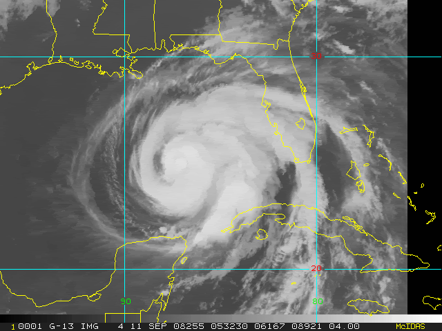
A G-13 image from a bit ago (05:32UTC), low res but something:

Image
0 likes   

User avatar
Melly
Tropical Low
Tropical Low
Posts: 16
Age: 43
Joined: Tue Aug 26, 2008 6:56 pm
Location: Port Neches, Texas (Southeast Texas)
Contact:

Re: ATL IKE: Category 2 - Discussion

#8591 Postby Melly » Thu Sep 11, 2008 1:14 am

bob rulz wrote:
Melly wrote:
artinla1 wrote:That was 946 millibars in the northwest quad. The 940 earlier was not from the same quadrant.


So, erm what does that mean? Again I'm a Noob at all this...


Not sure what you're confused about but the 946 millibar pressure was reported in the northwestern quadrant, but an earlier recon pass found a lower pressure in a different quadrant of the hurricane so it may not have sampled the lowest pressure yet.

EDIT: Of course, the lowest pressure is supposed to be in the CENTER, not one of the quadrants. Which is why his post confused me too?

Well I know nothing about the pressures, Rita was the first Hurricane I have ever been through, and I just had a baby so I just went with the flow, and Humberto just snuck up on us so I didn't really get to get much involved in that either.
0 likes   

User avatar
Melly
Tropical Low
Tropical Low
Posts: 16
Age: 43
Joined: Tue Aug 26, 2008 6:56 pm
Location: Port Neches, Texas (Southeast Texas)
Contact:

Re: Re:

#8592 Postby Melly » Thu Sep 11, 2008 1:16 am

Duddy wrote:
Melly wrote:Oh they just said its slowed down to 7mph is that bad? Doesn't the more it stay in the water, the more it can grow?


1AM advisory says 9MPH. WNW.


Where do you see that? The Weather Channel just said "7 MPH" and that it was on the 2am Advisory.
0 likes   

User avatar
artist
Category 5
Category 5
Posts: 9792
Joined: Mon Jun 06, 2005 3:26 pm
Location: West Palm

Re: ATL IKE: Category 2 - Discussion

#8593 Postby artist » Thu Sep 11, 2008 1:16 am

Aristotle wrote:Can someone tell me how to interpret this set from recon?

052100 2540N 08809W 6967 03040 9911 +100 +060 044062 063 047 006 00

The important columns for info for you -
1st column is time, second and third are the lat/longitude of the reading, next 2 not important to us, 6th column is barometric pressure within that portion of the storm (if it is 1002.3 then it would read 0023), 7th & 8th are air temp and dew point respectively. 9th is wind direction in degrees as well as the first fl level wind speed such as the one bolded above - 2250 is wind direction, the 47 is 47 knots at flight level - 30 second average. The 10th column is the 10 second average, 11th column is the surface winds per on board radar ( these are often incorrect and suspect if they are higher than the flight level winds found and will have a 999 next to them stating they are suspect. The flight level winds are anywhere from 10-15% higher than what is assumed to be at the surface. It depends on their flying height within the storm. If you follow the recon thread they usually will post what the reduction is.
This is what I sent to someone else. The numbers are different. Just fill in the ones from the line you posted.
0 likes   

User avatar
Sean in New Orleans
Category 5
Category 5
Posts: 1794
Joined: Thu Aug 28, 2003 7:26 pm
Location: New Orleans, LA 30.0N 90.0W
Contact:

#8594 Postby Sean in New Orleans » Thu Sep 11, 2008 1:16 am

Welcome to the board, I-Wall. I like your name! That is a New Orleans term! :D
0 likes   

User avatar
Duddy
Category 1
Category 1
Posts: 363
Joined: Sat Jun 10, 2006 9:07 pm
Location: Wilmington, NC

Re: Re:

#8595 Postby Duddy » Thu Sep 11, 2008 1:17 am

Melly wrote:
Duddy wrote:
Melly wrote:Oh they just said its slowed down to 7mph is that bad? Doesn't the more it stay in the water, the more it can grow?


1AM advisory says 9MPH. WNW.


Where do you see that? The Weather Channel just said "7 MPH" and that it was on the 2am Advisory.


Directly from the source, the National Hurricane Center.
http://www.nhc.noaa.gov/text/refresh/MI ... 0558.shtml

AT 100 AM CDT...0600Z...THE CENTER OF HURRICANE IKE WAS LOCATED
NEAR LATITUDE 25.0 NORTH...LONGITUDE 87.2 WEST OR ABOUT 645 MILES...
1040 KM...EAST OF BROWNSVILLE TEXAS AND ABOUT 305 MILES...495 KM...
SOUTH-SOUTHEAST OF THE MOUTH OF THE MISSISSIPPI RIVER.

IKE IS MOVING TOWARD THE WEST-NORTHWEST NEAR 9 MPH...15 KM/HR. A
GENERAL WEST-NORTHWESTWARD MOTION OVER THE CENTRAL AND WESTERN GULF
OF MEXICO IS EXPECTED TODAY AND FRIDAY.

MAXIMUM SUSTAINED WINDS ARE NEAR 100 MPH...160 KM/HR...WITH HIGHER
GUSTS. IKE IS A CATEGORY TWO HURRICANE ON THE SAFFIR-SIMPSON SCALE.
ALTHOUGH FLUCTUATIONS IN STRENGTH ARE POSSIBLE DURING THE NEXT
COUPLE OF DAYS...GRADUAL STRENGTHENING IS FORECAST DURING THIS
PERIOD...AND IKE COULD BECOME A MAJOR HURRICANE TODAY OR ON
FRIDAY.
0 likes   

bob rulz
Category 5
Category 5
Posts: 1704
Age: 35
Joined: Sat Jan 28, 2006 7:30 pm
Location: Salt Lake City, Utah

Re: ATL IKE: Category 2 - Discussion

#8596 Postby bob rulz » Thu Sep 11, 2008 1:17 am

Melly wrote:Well I know nothing about the pressures, Rita was the first Hurricane I have ever been through, and I just had a baby so I just went with the flow, and Humberto just snuck up on us so I didn't really get to get much involved in that either.


Lower pressures = higher wind speeds usually, and usually storms with a pressure this low have much higher wind speeds than this. The outer eyewall that the storm has is robbing convection from the center of the storm, thus making it harder to strengthen. The pressure suggests that if the storm can consolidate into a single eyewall that it will rapidly intensify, but that's yet to happen.

At least that's how I understand it.
0 likes   

I-wall
Tropical Storm
Tropical Storm
Posts: 210
Joined: Wed Sep 10, 2008 5:24 pm

Re: Re:

#8597 Postby I-wall » Thu Sep 11, 2008 1:17 am

Melly wrote:
Duddy wrote:
Melly wrote:Oh they just said its slowed down to 7mph is that bad? Doesn't the more it stay in the water, the more it can grow?


1AM advisory says 9MPH. WNW.


Where do you see that? The Weather Channel just said "7 MPH" and that it was on the 2am Advisory.


You wanna check the National Hurricane Center for the latest information. Here's a link: http://www.nhc.noaa.gov/index.shtml
0 likes   

I-wall
Tropical Storm
Tropical Storm
Posts: 210
Joined: Wed Sep 10, 2008 5:24 pm

Re:

#8598 Postby I-wall » Thu Sep 11, 2008 1:19 am

Sean in New Orleans wrote:Welcome to the board, I-Wall. I like your name! That is a New Orleans term! :D


Thanks for the warm welcome! :D
0 likes   

User avatar
Sean in New Orleans
Category 5
Category 5
Posts: 1794
Joined: Thu Aug 28, 2003 7:26 pm
Location: New Orleans, LA 30.0N 90.0W
Contact:

#8599 Postby Sean in New Orleans » Thu Sep 11, 2008 1:19 am

Possible squalls for New Orleans morning rush hour: http://www.srh.noaa.gov/ridge/radar.php ... 1&loop=yes
0 likes   

User avatar
Melly
Tropical Low
Tropical Low
Posts: 16
Age: 43
Joined: Tue Aug 26, 2008 6:56 pm
Location: Port Neches, Texas (Southeast Texas)
Contact:

Re: Re:

#8600 Postby Melly » Thu Sep 11, 2008 1:20 am

I-wall wrote:1AM advisory says 9MPH. WNW.


Where do you see that? The Weather Channel just said "7 MPH" and that it was on the 2am Advisory.[/quote]

You wanna check the National Hurricane Center for the latest information. Here's a link: http://www.nhc.noaa.gov/index.shtml[/quote]

Ah thanks... :)
0 likes   


Return to “2008”

Who is online

Users browsing this forum: No registered users and 5 guests