ATL: IKE Discussion

Moderator: S2k Moderators

Message
Author
User avatar
KWT
Category 5
Category 5
Posts: 31415
Joined: Tue Aug 17, 2004 11:02 am
Location: UK!!!

Re: Re:

#10641 Postby KWT » Fri Sep 12, 2008 10:07 am

lester88 wrote:
KWT wrote:Advisory says winds still at 90kts but this was probably done before the latest recon mission has come through which has shown winds of 114kts at flight level, which does not translate to 90kts but more like 100kts...

maybe a special adv. soon? :?:

-lester


Maybe, but as the NHC even state it really isn't going to make much if any difference to what is going to happen now, if people haven't got out of Galveston then they are just foolish.

Waters really are rising well now, surge still hasn't really ramped up yet according to the model...wave still splashing over the sea wall, won't be long before some of these waves splash over the other side as well.
0 likes   

pablolopez26
Tropical Storm
Tropical Storm
Posts: 137
Joined: Wed Aug 27, 2008 5:10 pm

Re: ATL IKE: Category 2 - Discussion

#10642 Postby pablolopez26 » Fri Sep 12, 2008 10:08 am

I took this shot from my TV this morning to show people that Ike is not playing around.

Image

Image
0 likes   

User avatar
WxGuy1
Professional-Met
Professional-Met
Posts: 538
Joined: Sat Oct 22, 2005 12:55 pm
Location: Oklahoma

Re: ATL IKE: Category 2 - Discussion

#10643 Postby WxGuy1 » Fri Sep 12, 2008 10:09 am

cpdaman wrote:"I don't mean to beat this topic into the ground, but I talked about it the last few days. What ended up happening was that Wilma is positioned under the right entrance region of a very potent jet streak located north to the storm. This is a very divergent portion of the jet and helped to establish a strong outflow channel to the north.

In addition, the storm's increase in forward speed helped to mitigate any shear since the storm was moving relative to the mean wind flow.


Dr. Lyons is talking about upper-level divergence that would enhance upward motion. Note that there are two ways (well, there are many more, but we'll mention only two here) to get upper-level divergence -- ageostrophic curvature divergence and ageostrophic divergence associated with the intertial-advective term. The former represent divergence that is east of a trough axis and west of a ridge axis (in the northern hemisphere). So, if you have a trough to the west, there will be some upper-level divergence (maximized, typically, at the inflection point between the trough and ridge). The 2nd force as play is associated with jet sreaks; the right-entrance and left-exit regions of upper-level jet streaks are typically characterized by upper-level divergence and upward motion.
0 likes   

User avatar
Hybridstorm_November2001
S2K Supporter
S2K Supporter
Posts: 2813
Joined: Sat Aug 21, 2004 2:50 pm
Location: SW New Brunswick, Canada
Contact:

#10644 Postby Hybridstorm_November2001 » Fri Sep 12, 2008 10:09 am

Duration of hurricane, and even gale force, winds is a lot more important than how strong the peak sustained winds in the small area around the eye is to over all wide spread damage.
Last edited by Hybridstorm_November2001 on Fri Sep 12, 2008 10:11 am, edited 2 times in total.
0 likes   

User avatar
Aristotle
Tropical Storm
Tropical Storm
Posts: 141
Age: 59
Joined: Wed Aug 27, 2008 8:16 pm
Location: Crowley, TX

Re: Re:

#10645 Postby Aristotle » Fri Sep 12, 2008 10:10 am

KWT wrote:
lester88 wrote:
KWT wrote:Advisory says winds still at 90kts but this was probably done before the latest recon mission has come through which has shown winds of 114kts at flight level, which does not translate to 90kts but more like 100kts...

maybe a special adv. soon? :?:

-lester


Maybe, but as the NHC even state it really isn't going to make much if any difference to what is going to happen now, if people haven't got out of Galveston then they are just foolish.

Waters really are rising well now, surge still hasn't really ramped up yet according to the model...wave still splashing over the sea wall, won't be long before some of these waves splash over the other side as well.


BTW what your seeing right now is simply Wave Setup. Not Surge. Simply Wave setup there is not a surge yet at all in Galveston. So look out!
0 likes   

User avatar
AZRainman
Tropical Storm
Tropical Storm
Posts: 146
Joined: Fri Sep 23, 2005 12:48 pm
Location: Sonoran Desert
Contact:

Re: Re:

#10646 Postby AZRainman » Fri Sep 12, 2008 10:11 am

rtd2 wrote:...people need to stop looking a cat 2 IKE and start seeing 20ft+ surge. folks inland away from the water should be fine.


S2k Members are plenty aware, but I doubt these holdout folks came here to see the storm surge maps I been posting all night and chat with the weather geeks:
Texas holdouts urge Hurricane Ike to "bring it on!" Reuters

Image

Image

More here
Last edited by AZRainman on Fri Sep 12, 2008 10:14 am, edited 4 times in total.
0 likes   

shah8
Category 1
Category 1
Posts: 363
Joined: Wed Aug 30, 2006 4:36 pm

#10647 Postby shah8 » Fri Sep 12, 2008 10:11 am

It's a big storm when hurricane force winds are larger in radius than the error cone out to 72 hours.
0 likes   

jinftl
Category 5
Category 5
Posts: 4312
Joined: Tue Aug 31, 2004 4:47 pm
Location: fort lauderdale, fl

Re: ATL IKE: Category 2 - Discussion

#10648 Postby jinftl » Fri Sep 12, 2008 10:12 am

Ike has been trying in some way to do this for days now....he has made it from cuba across the entire gulf...and the surge reflects this...but luckily the max winds are not as bad as they could be. i don't see a massive increase in winds taking place as he closes in on land...he is butting against the north american continent, not an island in the bahamas. soon, more and more of his circulation will be over land that is not swampy, close to another water source, etc. A cat 3 is still possible but at this point, that should not result in much of the way of additional preparation since a cat 4+ surge has been warned of for over a day and people inland should be ready for more likely than not Cat1/Cat2 conditions...even if landfall is at a Cat 3.

Jijenji wrote:The latest discussion says that Ike has no organized inner core...but to this amateur it looks like he is trying to wrap around a MASSIVE eye wall from the remnants of all the others. Not typical hurricane dynamics, but Ike has never really been typical in the GOM.
0 likes   

User avatar
KWT
Category 5
Category 5
Posts: 31415
Joined: Tue Aug 17, 2004 11:02 am
Location: UK!!!

Re: Re:

#10649 Postby KWT » Fri Sep 12, 2008 10:13 am

Aristotle wrote:BTW what your seeing right now is simply Wave Setup. Not Surge. Simply Wave setup there is not a surge yet at all in Galveston. So look out!


Well there is a little bit of surge but its no more then 4-5ft at the moment, still got a lot more to build up yet, Slosh model suggest 16.7ft for Galveston, pretty much oversplling the sea wall.
0 likes   

jinftl
Category 5
Category 5
Posts: 4312
Joined: Tue Aug 31, 2004 4:47 pm
Location: fort lauderdale, fl

Re: ATL IKE: Category 2 - Discussion

#10650 Postby jinftl » Fri Sep 12, 2008 10:14 am

that last wobble to the nw is good for galveston if we can get a heading more like that....compared to the heading in the prior plot points. east of galveston bay is better for them.


tolakram wrote:Image

Image
0 likes   

cpdaman
Category 5
Category 5
Posts: 3131
Joined: Sat Jun 10, 2006 11:44 am
Location: SPB county (gulf stream)

Re: ATL IKE: Category 2 - Discussion

#10651 Postby cpdaman » Fri Sep 12, 2008 10:14 am

don't attack me for bringing up the possibililty but i truly hope all those tie rods that hold the sea wall together are all very functionable throughout the storm

portions of sea walls can fail during storms, all it takes is a weak link or two, i am not saying this to SCARE people, but to get them to understand the potential for high water rises above just a few feet in parts of galveston.

i think the high tide around 230 pm will function as a nice wake up call to the people who have not gotten out of galveston, when they see the overwash which iMo will make the coastal road flooded out , while the storm is still appox 12 hours away from landfall (or another full high tide cycle away) , i HOPE they begin to understand this surge will be comparable with some of the highest surge the area has been hit by, god forbid this strengthens on the way in to the coast.
0 likes   

User avatar
vbhoutex
Storm2k Executive
Storm2k Executive
Posts: 29113
Age: 73
Joined: Wed Oct 09, 2002 11:31 pm
Location: Cypress, TX
Contact:

Re: IKE / Obs / Preparations / Web Cams / Texas / SW Louisiana

#10652 Postby vbhoutex » Fri Sep 12, 2008 10:18 am

dizzyfish wrote:I heard on the TV this morning that they have told residents in Houston to shelter in place and not evacuate. Can this be correct???


Yes it is correct. We have millions of residents that are not in surge zones. The people in the surge zones need to get out now if they haven't as the surge is already starting. The winds will not be fun, but the surge is not survivable in the areas under mandatory evacuation.

Current reports of: Buoy 42361: 125mph sustained

Buoy 42035: 20 miles E of Galveston: sustained at 33.5 g 55.

Obtaind from Harris County EM
0 likes   

jinftl
Category 5
Category 5
Posts: 4312
Joined: Tue Aug 31, 2004 4:47 pm
Location: fort lauderdale, fl

Re: ATL IKE: Category 2 - Discussion

#10653 Postby jinftl » Fri Sep 12, 2008 10:18 am

i would have thought everything being said by officials, media, etc for days would have been a wake-up call. It has been a wake-up for those who have gone to a safe location, even if that is 10 miles inland. For those who have not, they are not going to be looking or listening....esp if they wouldn't even go to a local shelter. I pray those people are changing their minds in the time that is left to get out of the surge.

cpdaman wrote:don't attack me for bringing up the possibililty but i truly hope all those tie rods that hold the sea wall together are all very functionable throughout the storm

portions of sea walls can fail during storms, all it takes is a weak link or two, i am not saying this to SCARE people, but to get them to understand the potential for high water rises above just a few feet in parts of galveston.

i think the high tide around 230 pm will function as a nice wake up call to the people who have not gotten out of galveston, when they see the overwash which iMo will make the coastal road flooded out , while the storm is still appox 12 hours away from landfall (or another full high tide cycle away) , i HOPE they begin to understand this surge will be comparable with some of the highest surge the area has been hit by, god forbid this strengthens on the way in to the coast.
0 likes   

User avatar
HURAKAN
Professional-Met
Professional-Met
Posts: 46086
Age: 38
Joined: Thu May 20, 2004 4:34 pm
Location: Key West, FL
Contact:

#10654 Postby HURAKAN » Fri Sep 12, 2008 10:19 am

0 likes   

User avatar
Aristotle
Tropical Storm
Tropical Storm
Posts: 141
Age: 59
Joined: Wed Aug 27, 2008 8:16 pm
Location: Crowley, TX

Re: ATL IKE: Category 2 - Discussion

#10655 Postby Aristotle » Fri Sep 12, 2008 10:19 am

jinftl wrote:Ike has been trying in some way to do this for days now....he has made it from cuba across the entire gulf...and the surge reflects this...but luckily the max winds are not as bad as they could be. i don't see a massive increase in winds taking place as he closes in on land...he is butting against the north american continent, not an island in the bahamas. soon, more and more of his circulation will be over land that is not swampy, close to another water source, etc. A cat 3 is still possible but at this point, that should not result in much of the way of additional preparation since a cat 4+ surge has been warned of for over a day and people inland should be ready for more likely than not Cat1/Cat2 conditions...even if landfall is at a Cat 3.

Jijenji wrote:The latest discussion says that Ike has no organized inner core...but to this amateur it looks like he is trying to wrap around a MASSIVE eye wall from the remnants of all the others. Not typical hurricane dynamics, but Ike has never really been typical in the GOM.


I think what you have to remember about this going to a Cat 3 (if it does). Remember they are keeping it a cat 2 even thought the surface winds don't justify Cat 2 strength. We saw SL winds at around 60 and 70 mph. If this becomes a justifiable CAT 3 with CAT 3 SL winds. That represents a huge jump. Just from the stand point of last night! Am I right?
0 likes   

physicx07
Tropical Storm
Tropical Storm
Posts: 215
Joined: Wed May 28, 2008 7:46 am
Location: Miami

Re: Re:

#10656 Postby physicx07 » Fri Sep 12, 2008 10:21 am

BTW what your seeing right now is simply Wave Setup. Not Surge. Simply Wave setup there is not a surge yet at all in Galveston. So look out![/quote]

There definitely is surge already at Galveston Pleasure Pier. Look at the tide gauge website here. We are at 6 feet above normal tide levels (normal tide is around +1ft right now, so 7 total):

http://tidesandcurrents.noaa.gov/quickl ... a/IKE.html
0 likes   

User avatar
KWT
Category 5
Category 5
Posts: 31415
Joined: Tue Aug 17, 2004 11:02 am
Location: UK!!!

#10657 Postby KWT » Fri Sep 12, 2008 10:21 am

jinftl, looks like Ike is bang on track, the systems center looks like coming right into Galveston directly if the current motion holds.
0 likes   

User avatar
vbhoutex
Storm2k Executive
Storm2k Executive
Posts: 29113
Age: 73
Joined: Wed Oct 09, 2002 11:31 pm
Location: Cypress, TX
Contact:

Re: ATL IKE: Category 2 - Discussion

#10658 Postby vbhoutex » Fri Sep 12, 2008 10:23 am

Buoy 42361: 125mph sustained

Buoy 42035: 20 miles E of Galveston: sustained at 33.5 g 55.

From Harris county emergency management.(Jeff Lindner)

We are now seeing 2-4 feet of surge even into the bay areas and the W end of Galveston Island is all but impassable except for really high ligt vehicles. Surge is also coming into the East end of the Island near UTMB. 61st street in Galveston under water in places as well as the Kemah Boardwalk on Galveston bay. Unfortunately this is not the "real" surge, just the beginnings.
0 likes   

smw1981
S2K Supporter
S2K Supporter
Posts: 253
Joined: Tue Jul 31, 2007 9:04 pm
Location: Alabamer

#10659 Postby smw1981 » Fri Sep 12, 2008 10:24 am

I've got to say, the NHC nailed this one a few days ago. It pretty much nailed Gustav a few days before LF too. Before these past two storms, I was not much of a believer in the NHC 3-day cone...however, I am now.

That being said, there has been plenty of time for people in Galveston to evacuate, and it is sad to think of all the people who saw a Cat 2 coming their way and decided to stay not knowing the surge potential with this storm. This would be why S2k is such a valuable resource when a hurricane is bearing down on you!
0 likes   

jinftl
Category 5
Category 5
Posts: 4312
Joined: Tue Aug 31, 2004 4:47 pm
Location: fort lauderdale, fl

Re: ATL IKE: Category 2 - Discussion

#10660 Postby jinftl » Fri Sep 12, 2008 10:24 am

Is that why people have stayed? They don't really think it is even a Cat 2...that the NHC is inflating it somehow?

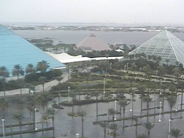
AN ELEVATED PLATFORM...122 METERS...400 FT HEIGHT NEAR THE CENTER
REPORTED SUSTAINED WINDS OF 109 KNOTS EARLIER THIS MORNING WHICH IN
COMBINATION WITH DATA FROM BOTH NOAA AND AIR FORCE RECONNAISSANCE
PLANES SUPPORT SURFACE WINDS OF 90 KNOTS AS THE INITIAL INTENSITY.

What you say is in total contradiction to the NHC....they are not trying to fool us into thinking an upgrade to a cat 3 is not as big a deal as you say when they state. Maybe this is what is at issue...people are not taking the NHC and their advisories at face value?

THERE IS STILL A CHANCE THAT IT COULD BECOME A MAJOR HURRICANE BEFORE
LANDFALL...BUT BASICALLY THIS IS IRRELEVANT SINCE WE ARE ONLY
TALKING ABOUT A 10-KNOT INCREASE.


Aristotle wrote:
jinftl wrote:Ike has been trying in some way to do this for days now....he has made it from cuba across the entire gulf...and the surge reflects this...but luckily the max winds are not as bad as they could be. i don't see a massive increase in winds taking place as he closes in on land...he is butting against the north american continent, not an island in the bahamas. soon, more and more of his circulation will be over land that is not swampy, close to another water source, etc. A cat 3 is still possible but at this point, that should not result in much of the way of additional preparation since a cat 4+ surge has been warned of for over a day and people inland should be ready for more likely than not Cat1/Cat2 conditions...even if landfall is at a Cat 3.

Jijenji wrote:The latest discussion says that Ike has no organized inner core...but to this amateur it looks like he is trying to wrap around a MASSIVE eye wall from the remnants of all the others. Not typical hurricane dynamics, but Ike has never really been typical in the GOM.


I think what you have to remember about this going to a Cat 3 (if it does). Remember they are keeping it a cat 2 even thought the surface winds don't justify Cat 2 strength. We saw SL winds at around 60 and 70 mph. If this becomes a justifiable CAT 3 with CAT 3 SL winds. That represents a huge jump. Just from the stand point of last night! Am I right?
0 likes   


Return to “2008”

Who is online

Users browsing this forum: No registered users and 4 guests