#3 Postby Chacor » Fri Sep 19, 2008 9:57 am
FQNT50 LFPW 190854
A
SECURITE
Weather bulletin for METAREA 2, METEO-FRANCE,
Toulouse, Friday 19 September 2008 at 09 UTC.
- Wind speed in BEAUFORT SCALE - Sea : Total significant -
- Please be aware, wind gusts can be a further 40 percent stronger
than the averages given here, and maximum waves may be up to twice
the significant height.
Part 1 : WARNING : nr 425.
Part 2 : General synopsis, Friday 19 at 00 UTC
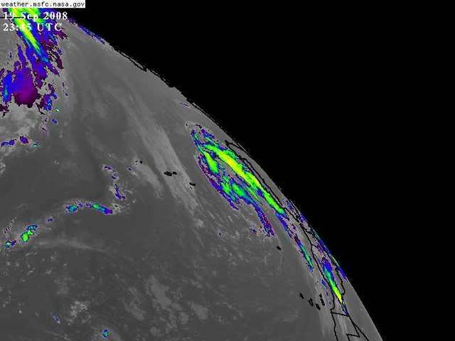
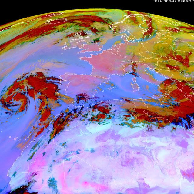
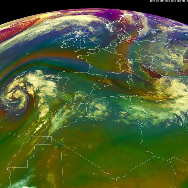
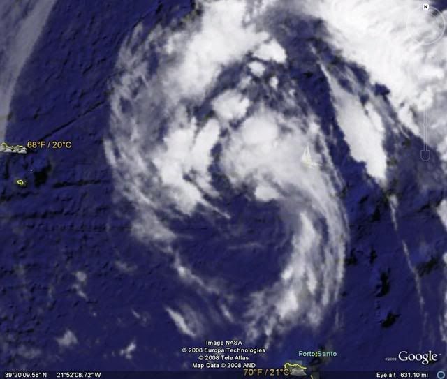
Thundery low 1011 over MADEIRA, moving northwest and deepening,
expected 1010 35N18W by 19/12UTC, then 1007 36N19W by 20/12UTC.
Disturbance crossing FARADAY and Northwest ALTAIR later.
High 1026 just south Ireland moving northeast and building,
expected 1033 just east Netherland by 20/12UTC.
New high expected 1035 46N49W by 20/12UTC.
Tropical wave along 25W/26W south of 18N, moving west 10 kt.
ITCZ along 11N15W 10N18W 12N25W 10N35W.
Part 3 : Area forecasts to Saturday 20 at 12 UTC
FARADAY :
In far southeast, Southerly 3 to 5. Elsewhere, Southerly 3 or 4
gradually veering Northerly 5 or 6. Gusts. Moderate, becoming rough
in northwest. Rain. Fog patches.
ROMEO :
In Northwest: Southerly 3 to 5. In southeast: Easterly 3 to 5.
Moderate.
ALTAIR :
In far southeast, East or Northeast 3 to 5 increasing 4 to 6 later.
Elsewhere, Variable 2 to 4 becoming North or Northeast 4 to 6
later. Gusts. Moderate. Rain or showers.
CHARCOT :
East or Northeast 3 to 5, increasing 5 to 7 in south soon.
Moderate or rough. Showers, locally thundersqualls with severe
gusts from south.
ACORES :
In west: Variable 2 to 4. In east: North or Northeast 4 or 5,
increasing 6 in northeast at end. Moderate, locally rough in east.
Rain and showers, locally thundersqualls with severe gusts.
JOSEPHINE :
In southwest: Cyclonic 6 to 8 decreasing 5 to 7 later. In
northeast, East or Southeast 5 to 7 veering South or Southeast 3
to 5 from south. Moderate or rough. Showers, locally
thundersqualls with severe gusts.
IRVING :
Northerly 3 to 5. Moderate. Rain and showers in east, locally
thundersqualls with severe gust.
MADEIRA :
Cyclonic 6 to 8, but South or Southwest in east and West or
Southwest in south, veering West or Southwest 4 to 6 everywhere
later. Moderate or rough. Showers, locally thundersqualls with
severe gusts.
PAZENN :
East or Northeast 3 to 5, veering East 4 or 5 later. Moderate or
rough in Northwest swell.
IROISE, YEU, ROCHEBONNE :
Northeasterly 3 or 4, veering Easterly 4 or 5 later. Slight or
moderate in Northwest swell. Thundery rain in south.
CANTABRICO :
In west: East or Northeast 3 or 4 veering Easterly 4 or 5 soon. In
east: Northerly 2 to 4 veering East or Northeast overnight. Slight
or moderate in Northwest swell. Thundery rain or showers.
FINISTERRE :
East or Northeast 4 to 6 decreasing 2 to 4 in south later. Moderate
or rough in Northwest swell.
PORTO :
Northeasterly 3 or 4, locally Northerly in far northeast, veering
Easterly soon, and becoming variable 3 to 5 later, Southeasterly
prevailing. Slight increasing moderate. Showers or thundersqualls
with severe gusts.
SAO VICENTE :
East or Southeast 3 to 5, veering Southeasterly soon, occasionally
6 in far southeast, but becoming variable 3 or 4 in east. Slight
or moderate. Showers or thundersqualls with severe gusts.
CADIZ, GIBRALTAR STRAIT :
In and leeward strait, Easterly 3 to 5 increasing 4 to 6 later.
Elsewhere, variable 2 to 4. Smooth to slight, becoming locally
moderate. Showers.
CASABLANCA :
In west, South or Southeast 3 to 5, increasing 4 to 6 soon, and
veering South or Southwest 3 or 4 later. In east, variable 2 to 4.
Slight or moderate. Showers or thundersqualls with severe gusts.
AGADIR :
Variable 3 or 4, mainly Southerly 5 in far northwest. Slight or
moderate. Showers or thundersqualls with severe gusts.
METEOR :
North or Northeast 3 or 4, locally Northwest far northeast.
Moderate in N or NE swell.
Some showers.
CANARIAS :
Mainly Westerly 2 to 4, but South 3 to 5 in northeast until 20/03
UTC, becoming later Northerly in southeast. Slight or moderate in N
swell. Some showers in north, locally thundery in northeast at
first.
TARFAYA :
Becoming North 2 to 4, veering East later, becoming Variable at
end.
Moderate in N swell, abating. Thunderstorms, decerasing later.
CAPE VERDE, CAP BLANC :
North or Northeast 3 or 4, locally Variable 2 or 3 in north of CAP
BLANC at first.
Moderate in N or NE swell. Some showers in CAPE VERDE.
CAP TIMIRIS :
North 3 or 4, increasing later 4 or 5. Moderate. N swell.
SIERRA LEONE :
Variable 2 to 4, but Northeast in northwest. Moderate in S or SE
swell.
Thundersqualls with severe gusts, mainly in southeast.
GULF OF GUINEA :
Southerly 3 to 5, locally 6. Moderate in S swell. Thundersqualls
with severe gusts.
POINTE NOIRE :
South or Southeast 3 to 5, but Variable 1 to 3 far east. Moderate
in S swell.
Part 4 : outlook for next 24 hours :
Persistence of thundery low southwest of JOSEPHINE with threat of
near gale or gale in CHARCOT, JOSEPHINE and MADEIRA. Elsewhere, ni
gale expected.
0 likes